Augment Education
    • Question bank
    • Quick fire
    • Worksheets
    • Flashcards
    • Notes
    • Try a quick-fire round
    • All features
    • Business
    • Digital Society
    • Economics
    • Geography
    • Global Politics
    • History
    • Philosophy
    • Psychology
    • Anthropology
    • World Religions
    • Biology
    • Chemistry
    • Physics
    • Computer Science
    • Design Technology
    • ESS
    • SEHS
    • Language and literature
    • Language acquisition
    • Maths AA
    • Maths AI
    • Dance
    • Film
    • Music
    • Theatre
    • Visual Arts
    • Grade calculator
    • Grade boundaries
    • Subject checker
    • Focus timer
    • Exam countdown
    • All free tools
    • IB guide
    • All subjects
  • Blog

Search

Search subjects, the syllabus, glossary terms, the booklets, the IB guide, help and the blog

Log inStart free
augment

Augment Education

IB Diploma revision built around the syllabus.

contact@augment-education.com

Product

  • Features
  • Question bank
  • Quick fire
  • Worksheets
  • Flashcards
  • Notes
  • Subjects
  • What's new

Learn

  • IB guide
  • Booklets, explained
  • Glossary
  • Blog
  • Free tools
  • Grade calculator
  • Subject checker

Company

  • About
  • Help
  • For parents
  • For teachers
  • Comparisons

Subjects

  • English A Lit
  • English A Lang & Lit
  • Chinese A Lit
  • Chinese A Lang & Lit
  • Spanish A Lit
  • Spanish A Lang & Lit
  • English Lit & Perf
  • Spanish Lit & Perf
  • English B
  • Mandarin B
  • Spanish B
  • English ab initio
  • Mandarin ab initio
  • Spanish ab initio
  • Business
  • Digital Society
  • Economics
  • Geography
  • Global Politics
  • History
  • Philosophy
  • Psychology
  • Anthropology
  • World Religions
  • Biology
  • Chemistry
  • Physics
  • Computer Science
  • Design Technology
  • ESS
  • SEHS
  • Maths AA
  • Maths AI
  • Dance
  • Film
  • Music
  • Theatre
  • Visual Arts

Augment Education is developed independently of the International Baccalaureate Organization and is not endorsed by it. “IB” and “International Baccalaureate” are its trademarks.

© 2026 Augment Education. All rights reserved.

  • Privacy
  • Terms
  1. Subjects
  2. Geography
  3. Paper 1: the options

Paper 1: the options

Plan your time in Paper 1, choose essay titles well, answer the structured stimulus question mark by mark, and write 10-mark essays that reach the top markband, with three full model answers from different options.

  • IB Geography
  • Exam skills
  • SL and HL

25 min readLast reviewed 18 Oct 2026

Paper 1 examines the options, the geographic themes studied in depth: Freshwater, Oceans and coastal margins, Extreme environments, Geophysical hazards, Leisure, tourism and sport, Food and health, and Urban environments. SL students answer on the two options they have studied and HL students on three. The paper is the same at both levels, so the advice applies equally to everyone.

Each option is worth 20 marks and is answered in two parts: a structured question of 10 marks built on a stimulus, and an extended response of 10 marks chosen from two essay titles. The two parts reward different skills. The structured question rewards precise reading and short, developed points; the essay rewards argument, evidence and evaluation.

How Paper 1 is set out

The paper has one section for each option, and you answer only the sections for the options you have studied. Within each one, the structured question is compulsory and comes first; the essay is a choice of two, usually printed as alternatives (“Either… or…”). The stimuli, often a topographic map extract, a graph, a table or a photograph, are printed in a separate resource booklet.

Because every option has the same shape, the same plan works for each. Treat each option as a self-contained 45 minutes and keep to it, so that a difficult structured question in the first option does not take time from the essay in the last.
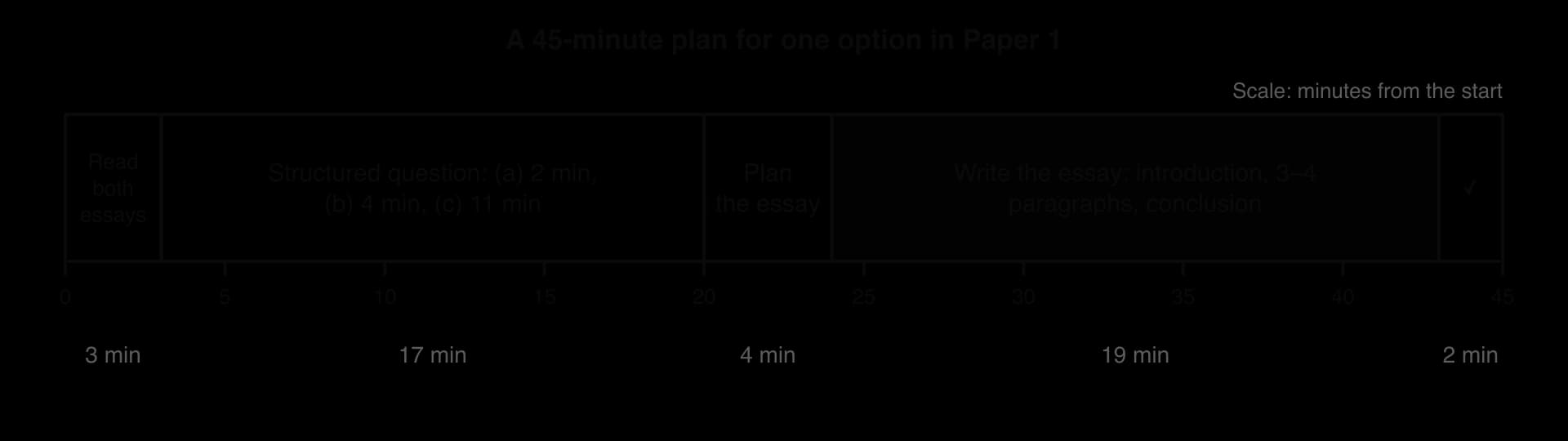
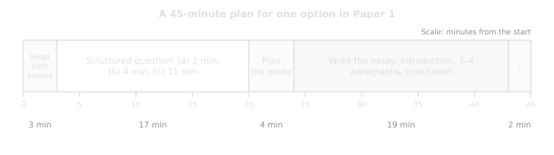
Timeline of 45 minutes for one Paper 1 option: read essay choices 3, structured question 17, plan essay 4, write essay 19, check 2 minutes.Timeline of 45 minutes for one Paper 1 option: read essay choices 3, structured question 17, plan essay 4, write essay 19, check 2 minutes.
The essay is worth as many marks as the structured question, so it deserves as much time. Reading both essay titles first lets ideas form while the structured question is being answered.

Tip

Answer the options in the order you know them best, not the order they are printed. Starting with the strongest option builds confidence and banks marks; just keep each option to its 45 minutes and label every answer clearly with its question number.

Choosing the essay question

Each option offers two essay titles, often one on physical processes or landforms and one on management or human impacts. A well-chosen title gains more marks than extra speed, because an answer that drifts from the question is capped however long it is. Spend two or three minutes on the choice and decide by the evidence you have, not by the topic you like.

Ask yourself

Choose the title if…

Avoid it if…

Do I understand every word, especially the command term and key terms?

You can define each key term in a sentence

You are unsure what a term means (“sustainable”, “resilience”, “the relative importance of…”)

Can I cover every element of the question?

You have evidence for both parts of “physical and human”, “costs and benefits”, “oil and plastic”

You know one half well and the other hardly at all

Do I have two or three located examples with figures?

You can name places, dates and numbers for each point

Your evidence is general (“in some countries…”)

Can I argue more than one side?

You can see where the claim is true, where it is not, and why

You could only write a one-sided account

Can I reach a judgment?

You already have a view you could defend

You would have to sit on the fence

Common mistake

Choosing the essay whose topic looks most familiar, then discovering halfway through that it asks for something else. “Examine the formation of meanders and floodplains” is not the same as “Examine the impacts of flooding on floodplains”. Read the command term and every element before you choose.

The structured question on a stimulus

The structured question usually has four parts that rise in demand. Its pattern is consistent enough to prepare for, although the exact split can vary from paper to paper.

Part

Marks

Typical command terms

What it asks for

(a)(i)

[1]

State, identify, estimate

One reading from the stimulus: a value, a direction, a place, a category

(a)(ii)

[1]

State, identify, estimate

A second reading, often needing a small calculation: a difference, a range, a height gain

(b)

[2]

Outline

One reason, way or problem [1] with its development [1], from the stimulus or general knowledge

(c)

[3+3]

Explain

Two reasons or ways, each [1] for the point and [2] for development, explanation or a located example

Parts (a)(i) and (a)(ii) test skill (AO4) and accuracy. Part (b) tests understanding of one process or impact. Part (c) is where most of the 10 marks are won or lost, because it needs two separate, developed explanations in about eleven minutes.

Exam tip

Topographic maps can appear as the stimulus in any option, so practise grid references, direction, distance, height and gradient on real map extracts. A six-figure grid reference, a compass direction or a height difference read from contours is a quick mark, but only if it is exact.

A full structured question

The table is the stimulus for a structured question from Option E, Leisure, tourism and sport. It shows visitors to a rural national park by month (hypothetical data).

Month

Jan

Feb

Mar

Apr

May

Jun

Jul

Aug

Sep

Oct

Nov

Dec

Visitors (thousands)

42

48

70

118

150

185

260

275

160

120

60

52

Worked example

Using the table:

(a)(i) State the month with the most visitors. [1]

(a)(ii) State the range of monthly visitor numbers. [1]

(b) Outline one reason for the seasonal pattern of visitors. [2]

(c) Explain two ways in which the managers of the park could reduce the impacts of visitors at its most popular sites. [3+3]

Show the markscheme and model answers

(a)(i) August ✓ (275,000 visitors).

(a)(ii) 275,000 − 42,000 = 233,000 visitors ✓. The unit matters: “233” without “thousand” would not be credited.

(b) School and work holidays are concentrated in July and August ✓, so families and students have the free time to visit then, when long days and warmer weather also suit outdoor activities such as walking ✓.

(c) Way 1: spread visitors in time with pricing ✓. Charging more for parking in July and August and less in spring and autumn ✓ encourages some visitors to come outside the peak, reducing crowding at honeypot sites when numbers are about six and a half times the January figure, and keeping use below the site’s carrying capacity ✓.

Way 2: harden and repair the most used paths ✓. Laying stone pitching on eroded routes up popular hills, as the Fix the Fells programme does in England’s Lake District ✓, stops walkers widening the path as they avoid mud, so the damage is confined to a durable surface and vegetation can recover beside it ✓.

Each way earns one mark for the strategy and two for explaining how it reduces impacts or giving a located example. The second answer uses a real example to earn its third mark; the first uses the stimulus.

The model answer to (c) links back to the stimulus (“about six and a half times the January figure”) and uses terms from the option (honeypot sites and carrying capacity) without spending time defining them. Both habits show understanding in very few words.

Common mistake

Answering (c) with strategies that do not match the question. The question asks how to reduce the impacts of visitors at the most popular sites, so marketing the park abroad, which would raise numbers, or building a new hotel elsewhere does not answer it. Underline what the strategy must achieve before choosing it.

Structured questions often use invented or simplified data, as here. The skills they test, reading values, quoting units and linking a pattern to a cause, are the same as for real data, but real examples from your option (such as a named national park) still earn credit in parts (b) and (c).

The 10-mark extended answer and its markband

Definition

Extended response: a longer written answer of 10 marks or more, such as an essay, marked holistically with a markband for knowledge, analysis, evaluation and structure.

The essay is marked with a markband of five bands, two marks wide. Each band has a headline description and a strand for each assessment objective: the knowledge and examples used (AO1), the argument and terminology (AO2), the evaluation and conclusion (AO3), and the structure and any diagrams (AO4). The examiner reads the whole answer and places it in the band that fits it best.
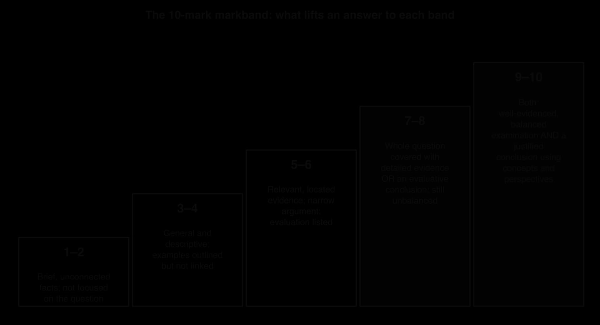
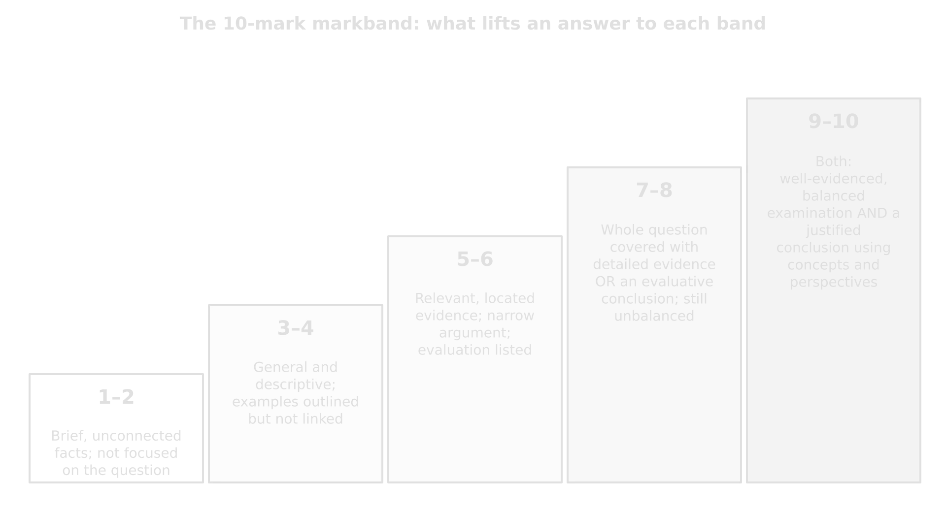
Five rising steps of the 10-mark markband: 1–2 brief unconnected facts; 3–4 general, descriptive; 5–6 relevant located evidence, narrow; 7–8 whole question or evaluative conclusion; 9–10 both, balanced and justified.Five rising steps of the 10-mark markband: 1–2 brief unconnected facts; 3–4 general, descriptive; 5–6 relevant located evidence, narrow; 7–8 whole question or evaluative conclusion; 9–10 both, balanced and justified.
The decisive step is from 5–6 to 7–8: a relevant, located answer becomes a structured argument that covers the whole question. The top band needs both a well-evidenced, balanced examination and a conclusion justified by concepts and perspectives.

Band

Knowledge and examples (AO1)

Argument and terms (AO2)

Evaluation and conclusion (AO3)

Structure and diagrams (AO4)

9–10

Correct, relevant examples, statistics and details integrated throughout

Balanced; complexity, exceptions and comparisons explained; complex terms used correctly throughout

Detailed evaluation of evidence and perspectives; conclusion balanced, relevant and aligned with the evidence

Logically structured and easy to follow; diagrams annotated and their relevance explained

7–8

Relevant evidence correctly described, covering all main points of the question

Clear and relevant, but one-sided or unbalanced

Other perspectives and strengths and weaknesses of evidence described; conclusion relevant but unbalanced

Related information grouped consistently; diagrams support the argument

5–6

Relevant evidence described with some links to the question

Partly addresses the question, or repeats one point

Perspectives listed; conclusion general or not aligned with the evidence

Grouping into paragraphs inconsistent

3–4

General; relevant and irrelevant facts mixed

Argument not relevant; basic terms with errors

No critical evaluation; conclusion irrelevant

Mostly not grouped logically

1–2

Very brief; unconnected or irrelevant; examples missing or only listed

No analysis; terminology missing or wrong

None

Not grouped; diagrams missing or unclear

What moves an answer up the bands

Markschemes for Paper 1 essays apply the bands with question-specific notes that follow a consistent logic. A weakly evidenced outline of the main process or factor reaches 5–6. A structured answer reaches 7–8 if it does either of two things: it examines the question’s main themes with good, located evidence (both sides, where the question has two), or it reaches a critical conclusion, or evaluates as it goes, using geographical concepts and perspectives. An answer that does both reaches 9–10.

Move

What to add

3–4 → 5–6

Stay on the question; replace general knowledge with relevant, located evidence

5–6 → 7–8

Cover the whole question, every element it names; use detailed examples (place, date, figure); define terms; one idea per paragraph; evaluate as you go

7–8 → 9–10

Add balance (other perspectives, exceptions, strengths and weaknesses of the evidence), explain complexity (interactions, variation by place, scale and time) and end with a balanced, justified conclusion

Exam tip

A conclusion “informed by geographical concepts” names the concept that decides the answer: power (who decides and who benefits), place (why the outcome differs here and there), scale (local gains, national costs), sustainability or equity, or possibility (how the answer may change in future). One sentence of this kind, grounded in the evidence, is often what separates 7–8 from 9–10.

Common mistake

Ignoring a limiting word in the title. Questions are capped when they drift: an essay asked about vector-borne disease that uses a disease spread another way, or one asked about a single named city that uses three, cannot reach the higher bands whatever its quality. If the title says “one named”, “contrasting” or “at a local scale”, the answer must do exactly that.

Planning in four minutes

A plan is the cheapest way to build in evaluation and perspectives, and to reach the higher bands, because most of what lifts an essay (covering every element, balance, a conclusion that follows from the argument) is decided before the first sentence. Four minutes is enough for a plan that lists the paragraphs, the evidence for each, the counter-argument and the judgment.

  • Decode the title. Underline the command term, circle the key terms and any limits (“two contrasting”, “in one country”).

  • Decide the answer. Write the one-sentence judgment you will defend. It can change as you write, but starting with one keeps the essay argued.

  • List three or four points, each with one or two located examples and a figure.

  • Add the other side: a counter-argument, an exception, another perspective or scale.

  • Note one concept (power, place, scale, equity, sustainability) that will frame the conclusion.

Tip

A plan does not need sentences. Abbreviations, arrows and place names are enough: “P1 groynes Mappleton 1991 £2m → village saved, erosion S ↑ (terminal groyne) | P2 sea walls… | CA soft cheaper Sand Motor | Concl: effective locally, costs moved downdrift (equity)”.

Structuring the essay

A clear structure is part of the mark (AO4), and it also makes evaluation easier to see. The simplest effective structure has an introduction that sets up the argument, three or four paragraphs each built round one point, a paragraph of counter-argument or complexity, and a short conclusion.
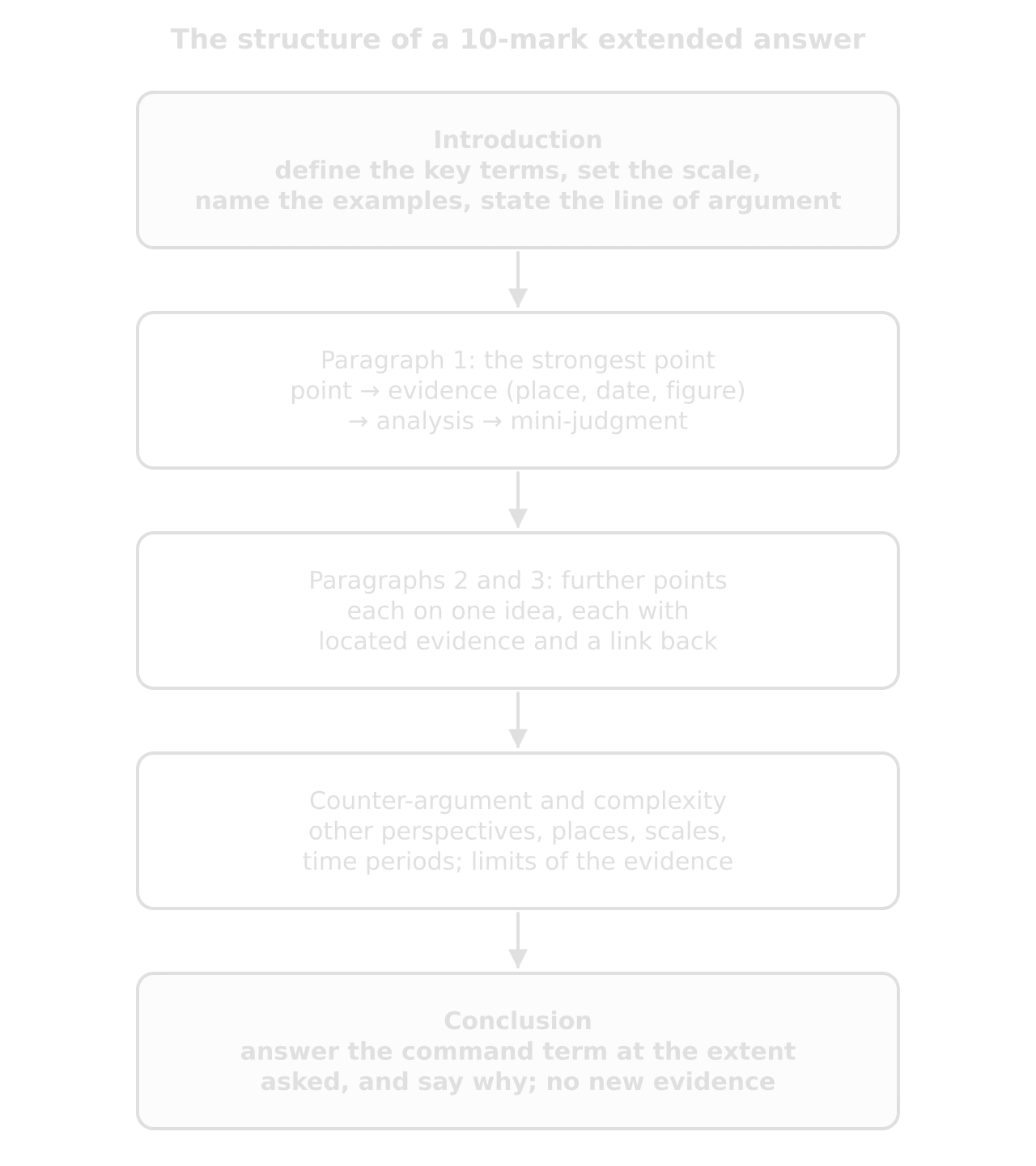
Flow of a 10-mark essay: introduction (terms, scale, examples, argument), paragraph 1 strongest point, paragraphs 2 and 3, counter-argument and complexity, conclusion answering the command term.Flow of a 10-mark essay: introduction (terms, scale, examples, argument), paragraph 1 strongest point, paragraphs 2 and 3, counter-argument and complexity, conclusion answering the command term.
The introduction and conclusion carry the judgment; the paragraphs between them carry the evidence. Each paragraph ends with a sentence that links its evidence back to the question.

The introduction

An introduction should take three or four sentences. It defines the key terms in the title, sets the scale or context, names the examples that will be used, and states the line of argument. It does not tell a story or repeat the question.

The paragraphs

Each paragraph makes one point. A reliable order is the point (a topic sentence that answers the question), the evidence (a named, located example with a figure and date), the analysis (why the evidence supports the point) and a short judgment (how far it does). The order can vary, but every paragraph needs both the evidence and the judgment.

The conclusion

The conclusion, a justified conclusion, answers the command term directly, at the extent asked, and gives the reason for that answer. It weighs the points already made rather than summarising them, and it adds no new evidence. A conclusion that contradicts the body, or that says only that “there are many factors”, is a common reason for an otherwise good essay to stay at 7–8.

Worked example

Two conclusions to “Evaluate the effectiveness of hard engineering in managing coastal erosion.” Which would earn more credit, and why?

A: “Hard engineering has advantages and disadvantages. It protects the coast but is expensive. Soft engineering is also used.”

B: “Hard engineering is effective at holding a specific line where valuable assets justify its cost, as at Mappleton, but it often moves erosion to undefended coast and becomes harder to justify as the sea rises. Its effectiveness therefore depends on the scale at which it is judged: a success for the protected village can be a loss for the coast as a whole.”

Show the commentary

B earns far more. It answers “how effective” with a judgment and its condition, uses an example from the body, and frames the verdict with the concept of scale and an equity issue. A is a summary that makes no judgment, introduces a new topic (soft engineering) without using it, and could have been written without studying the option.

Add to your notes: a bank of essay plans: one card per option with the six or eight likeliest essay types (process, landform, impacts, management, evaluation of a strategy, relative importance of factors), and for each a one-line judgment, three points with located evidence, a counter-argument and the key concept for the conclusion.

Three model answers from different options

The three essays come from Options A, B and G and use three different command terms. Each is shown with a plan, a full model answer and a note on the markband it would reach and why. The examples are drawn from each option’s own case studies and detailed examples, so their facts can be learned with the rest of the option.

Option A, Freshwater: an “Examine” essay

Worked example

Examine the impacts of agricultural activity on water quality. [10]

Show the plan, model answer and markband note

Plan. Define water quality; agriculture as a diffuse source → eutrophication (Lake Erie; Gulf of Mexico dead zone) → salinisation (Aral Sea basin) → why impacts vary: scale, climate, power, regulation (EU Nitrates Directive) → judgment: impacts are severe and widespread mainly because the source is diffuse and the costs fall downstream.

Model answer.

Water quality is the chemical, physical and biological condition of water, which decides whether it is fit for drinking, irrigation or ecosystems. Agriculture affects it more widely than any other activity, because it is the largest user of freshwater and its pollution is mostly diffuse: it comes from thousands of fields rather than one pipe. This answer examines two main impacts, eutrophication and salinisation, and argues that their severity depends less on farming itself than on climate, scale and who has the power to regulate it.

Examiner’s note: the introduction defines the key term, states the two impacts and gives a line of argument, so the examiner knows from the start that the essay will examine, not list.

The most widespread impact is eutrophication. Fertiliser and manure spread beyond what crops can take up are washed into rivers by runoff (phosphate) or leached through the soil (nitrate). In warm, still water the nutrients cause algal blooms; when the algae die, bacteria decomposing them use up the dissolved oxygen, producing hypoxic dead zones. In western Lake Erie, phosphorus from maize and soybean fields in Ohio’s Maumee basin fed a toxic Microcystis bloom in August 2014 that overwhelmed the treatment plant in Toledo, and about 400,000 people were told not to drink their tap water for two days. At a larger scale, nutrients carried by the Mississippi from the Midwest produce a dead zone in the Gulf of Mexico each summer, about 11,400 km² in 2025.

Examiner’s note: a process explained in the right order, then two located examples at different scales with figures and dates (AO1 and AO2 at the top band).

The assumption that farmers are simply to blame does not hold up, because the impact arises from the interrelationship between farming and the way pollution is governed. Point sources such as sewage works were cleaned up from the 1970s because they can be measured and fined; diffuse pollution cannot be traced to one farm, and each farmer gains little from cutting fertiliser when the benefit goes to people downstream. That is why the 2016 target of a 40% cut in phosphorus entering Lake Erie was missed in most years and a bloom of about 1,300 km² formed in 2019. Where regulation reaches the farm, outcomes differ: the EU’s Nitrates Directive (1991) sets rules on when and how much fertiliser can be spread in nitrate vulnerable zones, and Wales made its whole territory such a zone in 2021.

Examiner’s note: this paragraph does what “examine” asks: it uncovers an assumption and the interrelationships behind the impact, using perspectives (farmers, residents of Toledo, regulators).

Irrigation brings a second impact, salinisation, which matters most in dry climates. Where evaporation is high, water applied to fields evaporates and leaves its dissolved salts behind, and a rising water table brings more salt to the surface. In the Aral Sea basin, Soviet planners diverted the Amu Darya and Syr Darya from the 1960s to irrigate cotton, through canals that were poorly built: in 2012 only 12% of Uzbekistan’s irrigation canals were lined. By 2007 the sea had shrunk to about 10% of its 1960 area, its salinity had killed the native fish, and winds now blow salt and pesticide residues from the dry seabed onto fields. Here the impact on water quality was the result of a centrally planned decision that valued cotton above the lake.

The impacts also vary with place and can be reversed. The North Aral Sea recovered after Kazakhstan, with World Bank support, completed the Kok-Aral dam in 2005: its level rose 12 m by 2008 and salinity fell from about 30 to 8 grams per litre, so fishing resumed. The southern sea, which depends on decisions in several countries, has not recovered. This contrast shows that the scale at which water is managed shapes how lasting the damage is.

Examiner’s note: evaluation is ongoing: each paragraph ends with a judgment, and the counter-evidence (recovery) is used to sharpen the argument rather than tacked on.

Agricultural activity therefore has severe impacts on water quality, through eutrophication in humid farming regions and salinisation in irrigated drylands, and both can affect millions of people far from the farms that cause them. The impacts are not inevitable consequences of farming: they are greatest where pollution is diffuse and unregulated and where the people who bear the costs, such as Toledo’s residents or the fishers of Moynaq, have no power over the decisions upstream. Where governments regulate at the scale of the catchment or the lake, as the EU and Kazakhstan have, water quality can improve.

Markband: 9–10. The answer examines the whole question with detailed, located evidence at several scales (Lake Erie, the Gulf of Mexico, the Aral Sea), explains processes accurately, uncovers assumptions and interrelationships, and reaches a balanced conclusion grounded in the concepts of power and scale. Without the paragraph on governance and the recovery of the North Aral Sea it would be an accurate account of two impacts, at about 7–8.

The essay develops every impact it names. Two impacts, each with a process, a place and figures, examined for their causes and variations, earn more than six impacts named in a sentence each.

Option B, Oceans and coastal margins: an “Evaluate” essay

Worked example

Evaluate the effectiveness of hard engineering in managing coastal erosion. [10]

Show the plan, model answer and markband note

Plan. Define hard engineering and effectiveness (for whom, where, how long) → groynes: Mappleton 1991, village saved, erosion moved south → sea walls and timber defences: Happisburgh, protection lasts only while maintained → costs and cost–benefit → comparison with soft engineering and managed realignment (Sand Motor, Medmerry) → judgment: effective locally and in the short term, less so for the wider coast and the long term.

Model answer.

Hard engineering means building structures, such as sea walls, groynes, revetments and rock armour, that resist the energy of waves or trap sediment to protect the land behind them. Its effectiveness has to be judged on three measures: whether it stops erosion where it is built, what it does to the rest of the coast, and whether the protection lasts at a cost society will pay. On the first measure it is usually effective; on the other two it is much weaker.

Groynes show both sides clearly. At Mappleton on the Holderness coast of England, where the boulder clay cliffs had been retreating by about 1.7 m a year (1952–1989), a £2 million scheme in 1991 built two rock groynes and a revetment. The groynes trapped sediment moving south by longshore drift, the beach widened and the village and its road were saved. The same process starved the beach to the south, and erosion of the cliffs there increased, a terminal groyne effect. From the perspective of Mappleton’s residents the scheme was a success; from that of the farmers downdrift it moved their land into the sea faster.

Examiner’s note: a located example with a date, a cost and an erosion rate, then evaluation from two perspectives. This is the “ongoing evaluation” the top bands reward.

Protection also lasts only as long as it is maintained. At Happisburgh in Norfolk, timber defences built in 1959 decayed, and the cliff retreated by about 50 m between 1996 and 1999. In 2012 the shoreline management plan changed the policy for the village from holding the line to managed realignment (managed retreat), so the village would no longer be defended. Between 1988 and 2025, 35 homes were lost, and in a pilot scheme from 2009 to 2011 the council bought nine properties at 40% of their market value. Hard engineering is therefore effective only while someone is willing to pay for it, a weakness for sustainability, and cost–benefit decisions favour places with valuable assets, which raises a question of equity.

The alternatives show what hard engineering does not do. The Sand Motor in the Netherlands placed 21.5 million m³ of sand off the coast south of The Hague in 2011, for about €70 million, and lets waves and currents spread it along the shore for twenty years or more; it works with longshore drift rather than interrupting it. At Medmerry in West Sussex, a £28 million managed realignment in 2013 built a new 7 km floodbank inland and let the sea flood former farmland, creating saltmarsh that absorbs wave energy. Both protect without moving the problem along the coast, although they need space and public acceptance that a city seafront does not have.

Examiner’s note: the comparison is used to evaluate hard engineering, not to change the subject: each alternative is linked back to a weakness of hard structures.

Where cities, ports and infrastructure stand at the shoreline, hard engineering remains the only realistic option, and there it can be highly effective. Its main weaknesses are that it protects one place at the expense of another and commits society to rising maintenance costs as sea level rises.

Hard engineering is therefore effective in the short to medium term for the specific stretch it protects, as Mappleton shows, but less effective for the coastal system as a whole and in the long term. Its success depends on scale and on power: the people and assets behind the defence benefit, while those downdrift and future taxpayers bear the costs. As the sea rises, the length of coast where it is worth its cost is likely to shrink, so its most effective use is as part of a plan that combines it with soft engineering and managed realignment.

Markband: 9–10. Every paragraph evaluates, the evidence is detailed and located (dates, costs, erosion rates), several perspectives are weighed, the alternatives are used to judge rather than to describe, and the conclusion gives a verdict with conditions and concepts (scale, power, equity, sustainability). An answer that described each structure and its advantages and disadvantages in general terms, without named places, would reach 5–6.

Common mistake

Turning an “Evaluate hard engineering” essay into a description of soft engineering. Alternatives are useful only as a yardstick: each time one is mentioned, say what it shows about the strengths or weaknesses of the strategy the question names.

Option G, Urban environments: a “To what extent” essay

Worked example

To what extent have strategies to reduce urban air pollution been successful? [10]

Show the plan, model answer and markband note

Plan. Define air pollution and PM2.5; success measured against the WHO guideline and national standards → Beijing: national plan, closures and coal-to-gas, large fall → London: ULEZ, targeted vehicle charges, measurable fall → Delhi and Mexico City: partial or failed measures, regional sources → why success varies: scale, power, sources, equity → judgment: successful where governments act at the scale of the sources; limited elsewhere; nowhere yet at the WHO guideline.

Model answer.

Urban air pollution is the presence in city air of gases and particles at concentrations that harm health, above all fine particulate matter (PM2.5). Success can be measured in two ways: against a city’s own starting point, or against the World Health Organization’s guideline, which was lowered in 2021 to an annual mean of 5 µg m⁻³. On the first measure several strategies have been clearly successful; on the second, almost none has been, so strategies have succeeded only to a limited extent.

The largest success has come where a national government acted at the scale of the sources. After Beijing’s smog of January 2013, China’s State Council issued an Air Pollution Prevention and Control Action Plan that closed polluting mills and factories and switched millions of homes from coal to gas heating. Average PM2.5 across 74 major cities fell by about 42% between 2013 and 2018, and China’s population-weighted exposure fell from 52.2 µg m⁻³ in 2014 to 31.3 µg m⁻³ in 2024. The fall shows what concentrated power can achieve quickly, although exposure is still about six times the WHO guideline.

Examiner’s note: success is measured with figures against a stated benchmark, and a limitation is built into the same paragraph.

Targeted measures in high-income cities have also worked. London’s Ultra Low Emission Zone, a low emission zone, began in central London on 8 April 2019, charging £12.50 a day for vehicles that fail emissions standards, and was expanded to all of Greater London on 29 August 2023. Daily entries to the central zone by non-compliant vehicles fell from 35,578 to 23,054 soon after it started. Its limitation is equity: the charge falls most heavily on poorer drivers with older cars, while the health benefits go mainly to residents of busy roads, who are themselves often poorer.

Elsewhere strategies have had little effect, for reasons that show the limits of city-scale action. Mexico City’s Hoy No Circula programme of 1989, which bans each car from the roads on one weekday, brought little lasting improvement, partly because some households bought a second, older car. Delhi’s odd–even rationing in 2016 and 2019 emptied the roads but had little measurable effect on PM2.5, because vehicles are only one source.

Delhi’s annual mean was 99.6 µg m⁻³ in 2025, about 20 times the WHO guideline, and in winter much of its pollution comes from crop burning in Punjab and Haryana, states the city does not govern. The closure of the Badarpur coal-fired power station in October 2018 and the creation of a regional Commission for Air Quality Management in 2020 show that structural measures are possible, but annual levels have not fallen consistently.

Examiner’s note: the counter-argument is as well evidenced as the argument, and the reasons for failure (diffuse sources, regional scale, behavioural responses) are explained, which is what lifts a “To what extent” answer to the top band.

The contrast between Beijing and Delhi suggests that success depends on two conditions: action at the scale of the pollution’s sources, and the power to enforce it across administrative boundaries. Wealth matters less than governance, since China achieved its fall as a middle-income country, while technical measures alone, such as Delhi’s cloud-seeding trial of October 2025, have achieved nothing significant.

Strategies to reduce urban air pollution have therefore been successful to a moderate extent. Where governments have acted at the scale of the sources and enforced their rules, as in China and London, concentrations have fallen substantially; where the sources are regional and diffuse and power is divided, as in Delhi, they have not. No major city studied has reached the WHO guideline, so measured against health rather than against the past, success remains limited, and its costs and benefits are unevenly shared.

Markband: 9–10. The answer defines success and measures it against a benchmark, uses four cities at different levels of development with dates and figures, weighs both sides with equal evidence, explains why outcomes vary (scale, power, sources, equity) and states the extent of its agreement clearly. Remove the Delhi and Mexico City paragraph and the answer becomes one-sided, at 7–8 at most.

Exam tip

Give a benchmark for “success” or “effectiveness” in your introduction (the WHO guideline, a target the policy set itself, the situation before the strategy). It turns a vague judgment into one that can be measured, and it lets every paragraph say how far that benchmark was met.

What the three answers share

Feature

Option A (examine)

Option B (evaluate)

Option G (to what extent)

Line of argument stated early

Severity depends on climate, scale and power

Effective locally, weak for the wider coast

Success limited, judged against health

Located evidence with figures

Toledo 2014; Gulf dead zone 11,400 km²; Aral Sea 10%

Mappleton £2 million, about 1.7 m a year; Happisburgh 50 m

Beijing −42%; ULEZ entries; Delhi 99.6 µg m⁻³

Other side or complexity

Recovery of the North Aral Sea

Where hard engineering is the only option

Failure in Delhi and Mexico City

Concept in the conclusion

Power and scale

Scale, power, equity, sustainability

Scale, power, equity

Tip

Learn each case study in a form that can serve several command terms. The Mappleton figures support an evaluation of hard engineering, an examination of longshore drift and sediment cells, and a discussion of who gains and loses from coastal management. A single fact file can therefore serve three different essays.

Steps for each option in Paper 1

  • To do:

    Read both essay titles first (about 3 minutes), then answer the structured question in about 17 minutes.

  • To do:

    In (a)(i) and (a)(ii), give exact readings from the stimulus with units.

  • To do:

    In (b), write one point and one development; in (c), two separate reasons, each with two developments.

  • To do:

    Choose the essay for which you have located evidence covering every element of the title.

  • To do:

    Plan for about four minutes: judgment, three or four points with examples, the other side, a concept.

  • To do:

    Write an introduction that defines terms and states your line of argument.

  • To do:

    Make one point per paragraph with a named place, a date and a figure, and end each with a judgment.

  • To do:

    Include a counter-argument, an exception or another perspective, used to sharpen the argument.

  • To do:

    Finish with a conclusion that answers the command term at the extent asked, framed by a concept, then move to the next option on time.

Keep your place

In Augment the notes remember where you stopped and which pages you have finished.

Open in Augment

More IB Geography notes

  • Command terms and answer techniqueThe page before this.
  • Paper 2: the coreThe next page.
  • Geography assessmentEach Geography paper, the internal assessment and grade boundaries.
  • IB GeographyThe Geography syllabus, how it is assessed and every notes page.

Carry on with Geography in Augment

With a free account, Augment remembers where you stopped in the notes and which questions you have marked.

Start free