Command terms and answer technique
Recognise what each command term and assessment objective asks for, earn every mark in structured questions, use examples, case studies, diagrams and time well, and see model answers at every level on one topic.
- IB Geography
- Exam skills
- SL and HL
Every geography examination question tells you two things: what to write about (the topic, the place, the scale) and what to do with it. The second part comes from the command term, the word or phrase at the start of the question. “Describe” and “explain” can be asked about the same graph, but they want different answers, and an answer that does the wrong task earns few marks, however accurate its facts.
Command terms are linked to four assessment objectives, and the marks for every answer, from a 1-mark reading of a map to a 16-mark discussion, are awarded against them. Learning what each term asks for, how marks are given in a structured question, and how to use examples, time and diagrams is the quickest way to turn knowledge into marks.
How geography answers are judged
Examiners judge answers against four assessment objectives (AOs). Each describes a kind of thinking, and each command term belongs to one of them.
Objective | What it means in practice | Where it carries most weight |
|---|---|---|
AO1 Knowledge and understanding | Knowing the content: terms, processes, patterns, named places and their facts | Short parts of structured questions; the evidence base of every essay |
AO2 Application and analysis | Using that knowledge on unfamiliar material: reading a map or graph, explaining why a pattern exists, applying a concept to a place | “Explain” and “Suggest” parts; the analysis in every essay |
AO3 Synthesis and evaluation | Weighing evidence, linking ideas from different parts of the course (synthesis), considering other perspectives and reaching a judgment | 10-, 12- and 16-mark extended answers; the 6-mark infographic part |
AO4 Skills | Selecting and using skills: maps, graphs, diagrams, calculations, and well-structured writing with correct terminology | Stimulus readings, diagrams in answers, the structure of essays |
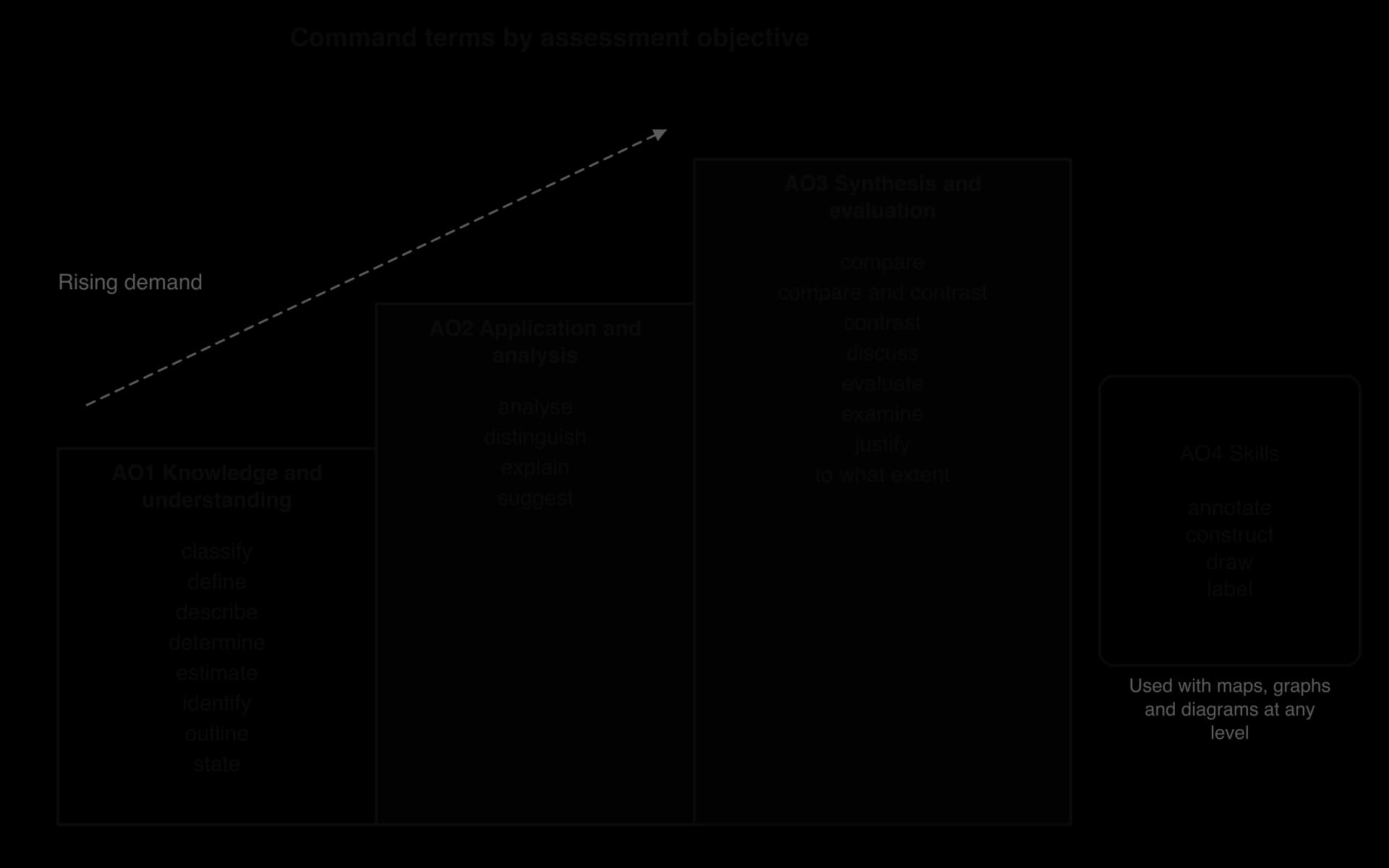
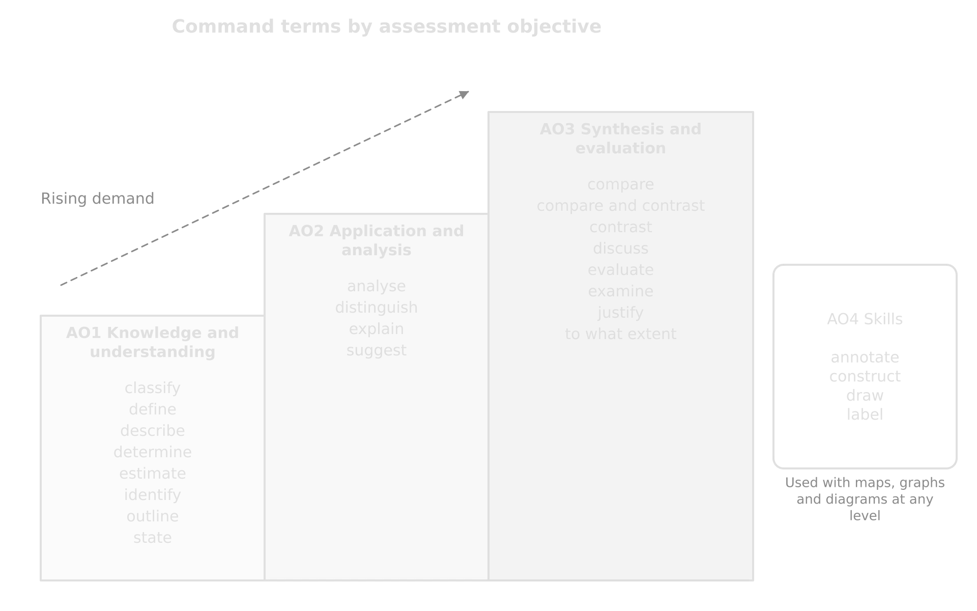
The objectives rise in demand from AO1 to AO3. A question that starts with “State” wants a single fact; one that starts with “Evaluate” wants knowledge (AO1), used to explain (AO2), then weighed to reach a judgment (AO3), all written in a clear structure (AO4). AO4 terms such as “draw” and “annotate” sit outside this ladder, because they name a skill rather than a depth of thinking.
Extended answers are not marked point by point. They are marked with a markband: a range of marks with a description of a typical answer in that range, judged on the answer as a whole. The descriptors for each band have one strand per assessment objective, so an answer full of accurate facts (AO1) with no judgment (AO3) cannot reach the top bands. Examiners apply the markbands using a markscheme for each paper, which lists creditable points for structured questions and notes on what each band looks like for each essay.
The command terms and what each asks for
Geography uses about two dozen command terms. Their meanings are fixed, and each one implies a particular shape of answer. The tables group them by assessment objective, from the least to the most demanding, with the kind of answer each needs and the marks it usually carries.
AO1 terms: show what you know
Term | What it asks for | What a good answer looks like | Usual marks |
|---|---|---|---|
State | A specific name, value or other brief answer, without explanation | One word, figure or phrase, with its unit: “2,982 m”, “north-east” | [1] |
Identify | One answer chosen from a number of possibilities | The name of the country, landform or category shown, exactly as on the stimulus | [1] |
Estimate | An approximate value | A value read from a graph or map to the precision its scale allows, with units | [1] |
Determine | The only possible answer, usually from data | The value, with the working where it is a calculation | [1]–[2] |
Define | The precise meaning of a word, phrase or concept | A one-sentence definition that would fit a glossary, with the key qualifiers (“the movement of…”, “per 1,000 per year”) | [1]–[2] |
Classify | An arrangement into classes or categories | Each item placed in its category, with the categories named | [1]–[2] |
Outline | A brief account or summary | One point and one development, in linked sentences | [2] |
Describe | A detailed account of what is there | The general pattern or trend, figures with units, and an exception; no reasons unless asked | [2] |
AO1 terms ask what, where, when and how much, not why. The commonest error with them is to explain, which wastes time and earns nothing. “Describe the trend” wants the direction, the rate and the figures; the reasons belong to a later part of the question, which will usually ask for them.
AO2 terms: use and analyse what you know
Term | What it asks for | What a good answer looks like | Usual marks |
|---|---|---|---|
Explain | A detailed account that includes reasons or causes | Each reason stated, then developed through the chain of cause and effect (“because… which… so…”), with an example where it helps | [2+2], [3+3], [3] |
Suggest | A possible answer: a solution, hypothesis or reason, often for an unfamiliar situation | A plausible reason linked to the context in the stimulus, then developed; any reasonable answer is credited | [2], [2+2] |
Distinguish | The differences between two or more concepts made clear | Both terms defined, and the difference stated explicitly in one sentence (“a hazard is the threat; a disaster is the harm it causes”) | [2]–[4] |
Analyse | Breaking an issue down to bring out its essential parts or structure | The issue split into parts (types, scales, stakeholders, mechanisms), each explained with evidence and linked to the others | [12] in Paper 3 part (a) |
“Explain” is the most frequent term in structured questions. Its marks are almost always split between reasons and their development, so a list of reasons earns little. “Suggest” sounds easier but is marked in the same way, with one extra rule: the suggestion must fit the place or situation in the question. A reason that would be true anywhere often earns only part of the marks.
AO3 terms: weigh the evidence and judge
Term | What it asks for | What a good answer looks like | Usual marks |
|---|---|---|---|
Examine | A study of an argument or concept that brings out its assumptions and interrelationships | Factors or arguments explained, then their links shown: how they interact, vary by place, scale and time, and what the question takes for granted; a judgment at the end | [10] |
Evaluate | An appraisal that weighs up strengths and limitations | Strengths and limitations of a strategy, model or policy, for whom, at what scale and over what time, then a verdict (“effective in the short term for…, less so for… because…”) | [6], [10] |
Discuss | A balanced review of a range of arguments, factors or hypotheses, with a clear, supported conclusion | Several arguments on more than one side, each evidenced, and an opinion that follows from them | [10], [16] |
To what extent | Consideration of the merits or otherwise of an argument, with a clear, supported conclusion | Evidence for and against the claim, and a conclusion that states the extent (“largely”, “only for…”) and why | [6], [10], [16] |
Justify | Valid reasons or evidence to support an answer or conclusion | A choice or claim backed by specific evidence, often after weighing the alternatives | [2]–[6] |
Compare | An account of the similarities between two or more items, referring to all of them throughout | Point-by-point similarities, with linking words such as “both” and “similarly” | [4]–[10] |
Contrast | An account of the differences, referring to all of them throughout | Point-by-point differences, with “whereas” or “in contrast” | [4]–[10] |
Compare and contrast | Similarities and differences, referring to all of them throughout | Both, point by point; never two separate descriptions | [4]–[10] |
The AO3 terms overlap, but each has its own emphasis. “Evaluate” puts strengths against limitations; “examine” looks for hidden links and assumptions; “discuss” wants a range of views; “to what extent” wants a measured verdict on a claim. All of them need evaluation and a justified conclusion, and all are marked with markbands.
AO4 terms: show the skill
Term | What it asks for | What a good answer looks like |
|---|---|---|
Label | Labels added to a diagram | One or two words on or beside each feature, joined by a ruled line: “levee”, “point bar” |
Annotate | Brief notes added to a diagram or graph | Short explanations on the diagram: “deposition on the inner bend, where velocity is lowest” |
Draw | A labelled, accurate diagram or graph, in pencil, with a ruler for straight lines | A clear diagram to scale where possible, with title, labels and axes; points plotted correctly |
Construct | Information displayed in diagrammatic or logical form | The right type of graph, flow chart or table for the data, with title, key and labelled axes |
One topic, rising demand: Dhaka at every level
The clearest way to see what each command term wants is to ask several questions about the same topic and compare the answers. Every question in this set is about the growth of Dhaka, a megacity in Bangladesh, and uses the fact file as its stimulus. The answers get longer and more argued as the command term moves from AO1 to AO3, while the evidence stays much the same.
Fact file: Dhaka, Bangladesh | |
|---|---|
Population of the city proper (2022 census) | 10.3 million |
Population of the urban agglomeration (2025 estimate) | 36.6 million, second largest in the world |
Density of the city proper | about 33,600 people per km² |
Share of the population in informal settlements (2016) | about 30% |
Share of water from groundwater (2021) | about 87%; water table falling 2–3 m a year |
Sewage treated | Dasherkandi plant (2023): 500 million litres a day, of about 2,000 million produced |
Average car speed in traffic | below 7 km per hour |
Garment industry (2025) | about 4.2 million workers, 54% of them women |
Metro Rail | MRT Line 6 opened 28 December 2022 |
Sources: UN DESA, World Urbanization Prospects 2025; Bangladesh Bureau of Statistics, census 2022; other figures via Wikipedia, “Dhaka” and “Textile industry in Bangladesh”, 2026.
AO1: state, identify, outline, describe
An “Outline” question asks for a brief account, which in a 2-mark part means one point and one development. The development can come from general knowledge as well as from the stimulus.
“Describe” needs evidence from the stimulus, quantified. Two short, separate points are the safest way to earn two marks.
AO2: explain and suggest
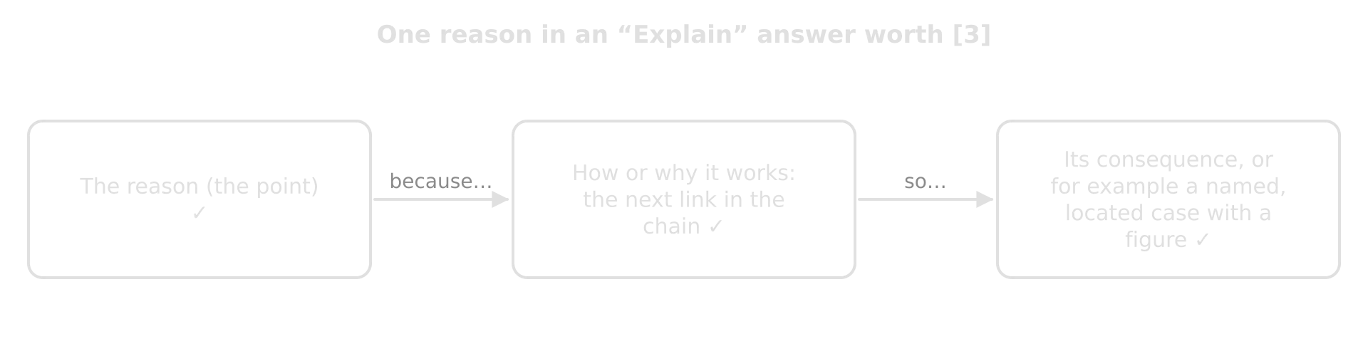
“Explain two reasons… [3+3]” is marked as two separate 3-mark answers. Each gets one mark for the reason and up to two for developing it: the next step in the chain, a consequence, or a located example.
“Suggest” asks for a plausible answer to something the stimulus does not explain directly. It rewards reasoning applied to the place in the question.
AO3: examine, evaluate, to what extent
The three AO3 questions on Dhaka could all be answered with the same facts, but each needs a different argument. The table sets out what changes; the model openings and conclusions show the difference on the page.
Question [10] | Central task | What the conclusion must say |
|---|---|---|
Examine the factors that have caused Dhaka’s infrastructure to fall behind its population growth. | Explain the factors (speed of migration, delta site, informality, finance, governance), then show how they interact and which matter most | Which factors matter most and how they reinforce each other |
Evaluate the Metro Rail as a response to the challenges of Dhaka’s growth. | Weigh strengths (speed, reliability, emissions) against limitations (coverage, fares, cost), for different groups and over time | A verdict on how effective it is, for whom and on what condition |
To what extent do women gain from the growth of Dhaka? | Evidence for (wages, independence, falling fertility) and against (low pay, informal housing, unsafe work, harassment), by group | The extent of agreement, stated and justified (“largely, for factory workers, but…”) |
An evaluation keeps returning to the same question, “how well does it work, and for whom?”, rather than describing the response.
“To what extent” sets up a claim to be tested. The conclusion must state how far it holds, not simply that “there are arguments on both sides”.
How structured questions are marked
A structured question is marked point by point from a markscheme that lists the creditable answers. Each valid point earns one mark, up to the maximum for the part, and the marks beyond the first in a reason are for its development. Knowing this rule changes how answers should be written: briefly, in separate points, and with every point carried one step further.
One mark per point, and marks for development
A developed point is a point that goes beyond a bare statement. It explains how or why the point works, gives its consequence, or supports it with a named, located example. In a 2-mark “Outline”, one point plus one development earns both marks. In a 3-mark “Explain”, the reason earns one mark and two developments earn the other two.

Answer to “Explain one reason why urban areas flood more quickly than rural areas. [3]” | Marks |
|---|---|
“Concrete.” | 0: a word, not a reason |
“There are more impermeable surfaces in cities.” | 1: the reason |
“Impermeable surfaces such as roads and roofs stop infiltration, so more rain becomes overland flow.” | 2: reason + one development |
“Impermeable surfaces such as roads and roofs stop infiltration, so more rain becomes overland flow, and storm drains carry it straight to the river, shortening the lag time and raising peak discharge.” | 3: reason + two developments |
The same idea runs through every structured part. The difference between one mark and three is rarely more knowledge. It is usually the habit of finishing the chain from cause to effect.
“Two reasons, each developed”
Questions such as “Explain two ways…” or “Suggest two reasons…” are marked as separate halves, [2+2] or [3+3]. The examiner credits the first two reasons only. Writing a third reason gains nothing, and a third reason squeezed in while the first two are left undeveloped loses marks that were within reach.
Using the stimulus with figures and units
Most structured questions are built on a stimulus: a map, graph, table, photograph or diagram, printed in a separate resource booklet. When a question says “shown in the graph” or “in the photograph”, the answer must use it. Markschemes for “Describe” parts often note that answers should quantify for full marks, and “Suggest” parts may be capped if the answer ignores the context the stimulus sets, such as an arid area or a coastal city.
Quote figures with units and dates: “fell from 68,000 km² in 1960 to about 10% of that by 2007”, not “fell a lot”.
Give the general pattern first, then the exception: “most provinces recorded fewer than 1,000 deaths, but Hatay recorded 24,147”.
Use the stimulus’s own words for categories, places and keys, so the examiner can match them.
Read the scale and units carefully: thousands or millions, per cent or percentage points, mm or cm, per year or in total.
Using examples and case studies
Geography answers are judged on the quality of their evidence. A general point (“cities in poorer countries have more slums”) shows understanding, but a point supported by a specific place, figure and date shows knowledge, and it is what lifts an answer from the middle markbands to the top. Examiners distinguish two kinds of evidence: the short detailed example and the longer case study.
An example enriches one point. It names the place and adds at least one precise fact: a location, an amount or a date. “Bangladesh” on its own is not an example; “Bangladesh’s Cyclone Preparedness Programme, whose volunteers helped to evacuate about 2.2 million people before Cyclone Amphan in May 2020” is. An essay may use many examples, each supporting a different point.
A case study is a fuller body of evidence about one place or event, used to argue rather than to narrate. It should be recent, ideally within your lifetime, so that data are available and it reflects current conditions; a historic event such as the eruption that buried Pompeii is not a suitable case study. Where a question asks for a case study, it says so (“with reference to one named city”), and the case study must match the question exactly.
Level of evidence | Example (megacity growth) | What it earns |
|---|---|---|
Unlocated | “Megacities in poor countries have many slums.” | Shows understanding only; no credit for knowledge of place |
Named | “Dhaka has many slums.” | A little more: the place is named but nothing is known about it |
Located and specific (a detailed example) | “About 30% of Dhaka’s population lived in informal settlements in 2016, such as Korail beside the towers of Gulshan.” | Credit for knowledge: place, figure, date, a named district |
Used as evidence (part of a case study) | “Because about 30% of residents lived in informal settlements in 2016, where utilities do not invest, the shortfall in sewerage feeds itself…” | Credit for analysis: the evidence supports an argument |
Time per mark
Every geography paper is tightly timed, and the papers give different amounts of time per mark, so the same number of marks deserves different amounts of writing in different papers. A useful rule is to divide the minutes available by the marks: the result is the time a mark is worth, including reading and planning.

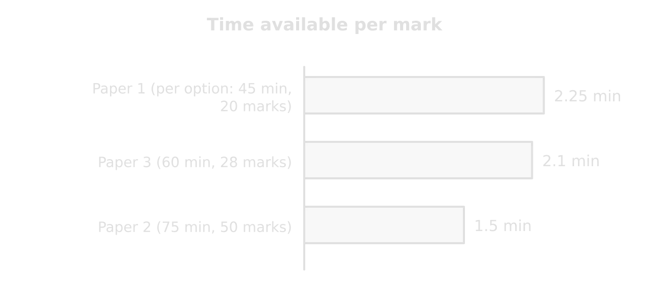
A 1-mark “State” in Paper 2 is worth about 1–2 minutes: read the stimulus, write the value, move on.
A [3+3] “Explain” in Paper 1 is worth about 11–13 minutes, including a few seconds to choose the two reasons.
A 10-mark essay in Paper 1 is worth about 22 minutes, of which 3–4 minutes should go on a plan.
Part (b) of Paper 3, worth 16 marks, is worth over half an hour; part (a), worth 12, about 25 minutes.
Diagrams and sketch maps in answers
A good diagram can replace a paragraph, and in extended answers the top markband credits maps, graphs or diagrams that are annotated following conventions and whose relevance is explained. A diagram earns credit only when it is accurate, labelled or annotated, and referred to in the text (“as the annotated hydrograph shows…”). A decorative sketch with no labels earns nothing.
Labelled and annotated diagrams
Labels name features; annotations explain them. In an answer, annotations are almost always more useful, because they turn a drawing into an explanation. A sketch of a groyne field is labelled with “groyne”, “beach” and “longshore drift”; annotated, it adds “sediment trapped on the updrift side” and “beach starved downdrift: erosion increases”.
Diagram | Where it helps | Annotations that earn credit |
|---|---|---|
Storm hydrograph (urban and rural) | Flooding, urbanisation | Shorter lag time, higher peak, steeper rising limb, with the reason for each |
Cross-section of a landform | Coasts, rivers, glaciers | Process arrows (erosion, deposition, drift) and the order of formation |
Sketch map of a case study | Any located example | Key places, the hazard or flow, and two or three notes on causes or impacts |
Flow diagram or cycle | Causes, feedback loops, cycles of poverty | Each link explained (“which reduces…”) |
Sketch graph of a model (Butler, the DTM) | Tourism, population | Stages labelled with features and a real place at each |
Sketch maps
A sketch map is a simple map drawn from memory to show the location and key features of a place. It is not a work of art: what matters is that it is clear, correct and follows the conventions every map should have.
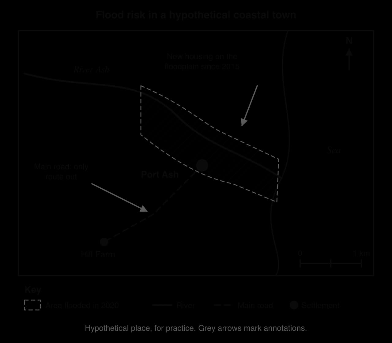
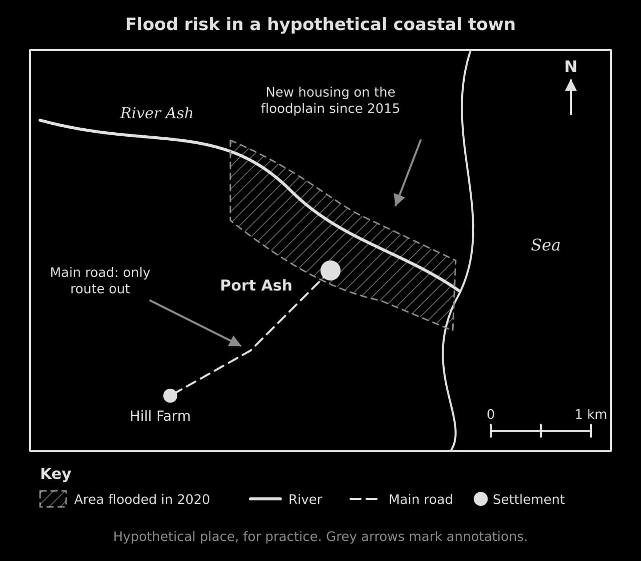
Title saying what and where.
Frame and a simple outline: coast, river, border, main roads.
North arrow and scale (or “not to scale”).
Key for every symbol or shading.
Labels for the places named in your answer, and nothing more.
Annotations (short notes with arrows) that explain why the map matters to the question.
A routine for every question
The same few steps work for every geography question, from a 1-mark reading to a 16-mark discussion. Practised until they are automatic, they stop the commonest losses of marks: the wrong task, half the question, an undeveloped point or an unsupported conclusion.
- To do:
Underline the command term and decide which assessment objective it belongs to.
- To do:
Circle every element of the question: topic, place, scale, and each part (“costs and benefits”, “physical and human”).
- To do:
Check the marks and divide your time: about 1.5 minutes per mark in Paper 2, a little over 2 in Papers 1 and 3.
- To do:
For a stimulus, read the title, units and key first, then quote figures with units in your answer.
- To do:
In structured parts, give exactly the number of points asked for and develop each one (“because… so…”).
- To do:
Support every point in an extended answer with a named, located example with a figure or date.
- To do:
Add a labelled or annotated diagram or sketch map only where it supports a point, and refer to it.
- To do:
In AO3 answers, state your line of argument early, evaluate as you go, and end with a justified conclusion at the extent asked.
Carry on with Geography in Augment
With a free account, Augment remembers where you stopped in the notes and which questions you have marked.