Evaluate how ocean minerals, oil, gas and fish are used and managed, judge strategies against radioactive, oil and plastic pollution, and explain why choke points, islands and the South China Sea are contested.
Each is in the Geography glossary, with every other term in the subject.
A natural resource that comes from non-living parts of the environment, such as minerals, oil, gas, sand or water, rather than from living organisms.
The farming of fish, shellfish, seaweed and other aquatic organisms in ponds, tanks, cages or other enclosures.
An island created by people by piling sand, rock or other material onto a reef or seabed, or by building a platform; under UNCLOS it generates no territorial sea or EEZ.
A natural resource obtained from living organisms, such as fish, shellfish, marine mammals or seaweed.
Fish and other marine animals, such as dolphins, turtles and seabirds, caught unintentionally while fishing for a target species.
The harvesting of wild fish and other aquatic animals from the sea, rivers and lakes, as opposed to farming them.
The principle that certain areas and their resources, such as the deep seabed beyond national jurisdiction, belong to all humanity and must be managed for the benefit of all.
The extraction of mineral deposits such as polymetallic nodules, seafloor massive sulphides and cobalt-rich crusts from the deep-ocean floor.
Describe the main abiotic resources of the oceans and explain why demand for them is rising.
Evaluate the environmental, economic and legal consequences of extracting offshore oil, gas and seabed minerals.
Describe trends in the use of fish and marine mammals, using capture and aquaculture data.
Evaluate the viability of aquaculture, conservation areas and quotas as alternatives to overfishing.
Evaluate local and global strategies for managing radioactive, oil and plastic pollution of the oceans.
Explain the strategic value of the oceans and why islands, canals and choke points cause conflict.
Discuss whether the oceans can be managed sustainably as a global commons.
Examine a contested ocean area, the South China Sea, from the perspectives of the states involved.
The oceans cover about 71% of the Earth’s surface and supply fish, oil, gas, minerals, sand and energy, carry most of the world’s trade and absorb much of its waste. As demand for these resources rises, the oceans are being used more intensively, and the rules that govern them are being tested.
The topic is about possibility and power. Whether fish stocks recover, seabed mining begins or plastic pollution falls depends on choices still being made, and those choices are shaped by the states and companies with the most power at sea: coastal states controlling their exclusive economic zones, naval powers, and the fishing and energy industries.
66 exam-style questions on this subtopic, written in the style of the IB papers. The first has its markscheme open. Counted on
Examine the causes and consequences of the increasing exploitation of offshore oil and gas.
10 marks
Marks should be allocated according to the markbands.
Offshore oil and gas are abiotic (non-living) ocean resources extracted from beneath the seabed, from shallow continental shelves to ultra-deepwater fields more than 1,500 m below the surface. Causes may be economic, technological, political or demographic; consequences may be environmental, economic, social or geopolitical, and may be positive as well as negative. Credit answers that examine causes and consequences at different scales (local, national, global). Do not expect perfect balance between causes and consequences.
Possible applied themes (AO2) demonstrating knowledge and understanding (AO1):
Rising global energy demand, driven by population growth and economic growth in emerging economies (eg China and India), together with the depletion of many onshore fields, pushes companies offshore; offshore fields supply roughly a quarter to a third of world oil production.
Technological change: floating production platforms, horizontal drilling and seismic imaging have opened deepwater frontiers such as Brazil's pre-salt fields in the Santos Basin (discovered 2006–2007) and the Gulf of Mexico.
High oil prices make costly deepwater projects profitable; energy security motivates states to develop resources within their own exclusive economic zones (EEZs), eg Norway's North Sea and Arctic fields.
Economic consequences: rapid growth in national income and government revenue, eg Guyana, where production from ExxonMobil's Stabroek block began in December 2019 and transformed GDP growth; jobs and the multiplier effect in ports such as Aberdeen (UK).
Environmental consequences: risk of major spills, eg Deepwater Horizon (20 April 2010, Gulf of Mexico), when 11 workers died and about 4.9 million barrels of oil were released over 87 days, damaging fisheries, wetlands and tourism; routine discharges, noise from seismic surveys affecting cetaceans; greenhouse gas emissions when the fuels are burned.
With a free account, Augment remembers where you stopped and what you have practiced.
A population of one fish species in a particular area that is managed as a single unit.
A limit on the amount of fish that a country, fleet, vessel or business may catch, usually a share of a total allowable catch.
The right of ships of all states to sail through international waters, and through EEZs, without interference, as set out in UNCLOS.
An area of an ocean gyre where floating plastic and other debris carried by surface currents accumulates in high concentrations.
An area or resource outside the jurisdiction of any single state, such as the high seas, the atmosphere or Antarctica, that is shared by all.
The parts of the ocean beyond any state's exclusive economic zone, open to all states and governed by international law.
An opening in the seabed, usually on a mid-ocean ridge, from which water heated by magma flows out, depositing metal-rich sulphide minerals and supporting unique ecosystems.
Fishing that breaks national or international rules, is not reported to the authorities, or takes place where no rules apply, for example by stateless vessels.
A share of a total allowable catch held by an individual or company, which can be bought, sold or leased.
The organisation set up under UNCLOS that regulates mineral exploration and mining on the seabed beyond national jurisdiction, based in Kingston, Jamaica.
The international treaty of 1972 controlling the deliberate dumping of wastes at sea from ships, aircraft and platforms; since 1993 it has banned dumping radioactive waste.
Plastic waste in the sea, from large items such as bottles, bags and fishing nets to tiny fragments known as microplastics.
A disagreement between states over sovereignty of islands or other features, the boundaries of maritime zones, or rights to use the sea and its resources.
The International Convention for the Prevention of Pollution from Ships (1973, modified 1978), which regulates discharges of oil, chemicals, sewage, garbage and air pollutants from ships.
The largest catch that can be taken from a fish stock year after year without reducing its size, reached when the stock is kept at a medium level.
A piece of plastic smaller than 5 mm, either manufactured at that size, such as microbeads, or formed when larger plastic breaks down.
The introduction by people of substances, objects or energy into the sea that harm living resources, human health or legitimate uses of the sea.
Petroleum and natural gas extracted from rocks beneath the seabed using fixed platforms, floating production units or drill ships.
The release of liquid petroleum into the environment, especially the sea, from tankers, pipelines, offshore platforms or wells.
Catching fish from a stock faster than it can replace itself through reproduction and growth, so that the stock declines.
A lump of minerals a few centimetres across, rich in manganese, nickel, cobalt and copper, that forms very slowly on the deep-ocean floor.
Material that emits ionising radiation, produced by nuclear power, fuel reprocessing, weapons and medicine, which must be isolated from people and the environment.
A sudden and severe fall in a fish population, usually to a small fraction of its former size, from which it may recover only slowly or not at all.
The importance of a place or area to a state's security, economy or power, for example because it controls a trade route, a choke point or resources.
The maximum quantity of a fish stock that may be caught in a period, usually a year, set to keep the stock at a sustainable level.
The tendency for a shared resource open to all to be over-used and degraded, because each user gains the full benefit of using more while the costs are shared by everyone.
The pause on all commercial whaling agreed by the International Whaling Commission in 1982, which took effect in 1986.
An abiotic resource is a non-living natural resource. In the oceans the main ones are oil and natural gas beneath the seabed, metal-rich minerals on and below the deep-sea floor, sand and gravel, salt, and energy from wind, waves and tides. Where they lie decides who controls them: resources within 200 nautical miles of a coast fall within a state’s exclusive economic zone, while those under the high seas lie in the international seabed area.
Offshore oil and gas are hydrocarbons extracted from rocks beneath the seabed using fixed platforms in shallow water, or floating platforms and drill ships in deep water (over about 500 m) and ultra-deep water (over about 1,500 m). Offshore fields supply a large share of the world’s oil and gas, from the North Sea, the Gulf of Mexico and the Persian Gulf to newer deep-water provinces.
Brazil’s pre-salt fields lie beneath about 2,000 m of salt, which is itself under more than 2,000 m of sediment in deep water off the coast. They have made Brazil a major oil exporter.
Guyana, one of South America’s poorer countries, began offshore production in 2019 after ExxonMobil discoveries in 2015. Oil output reached 261 million barrels in 2025, and real GDP grew by 43.8% in 2024, among the fastest growth rates in the world.
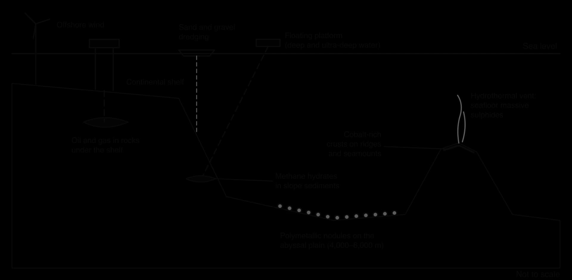
Deep-sea mining is the extraction of mineral deposits from the deep-ocean floor, usually below 200 m and often at 4,000–6,000 m. Three types of deposit interest mining companies:
Polymetallic nodules: potato-sized lumps rich in manganese, nickel, copper and cobalt that form very slowly on the abyssal plains. The Clarion–Clipperton Zone in the Pacific, between Hawaii and Mexico, covers about 4.5 million km² and holds an estimated 21 billion tonnes of nodules.
Seafloor massive sulphides: deposits of copper, zinc, gold and silver formed at hydrothermal vents, where seawater heated by magma pours out of the seabed along mid-ocean ridges.
Cobalt-rich crusts: thin layers of metal oxides on the flanks of seamounts and ridges.
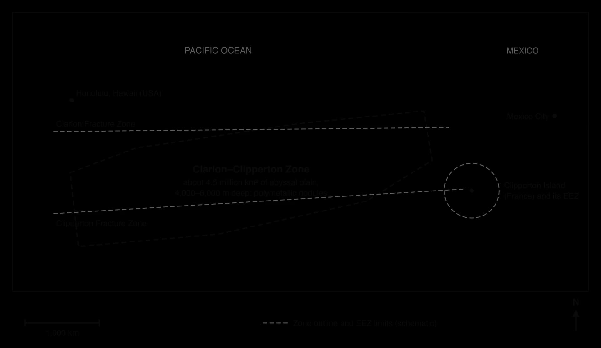
The map shows why the Clarion–Clipperton Zone is the main target for nodule mining. It is a vast, flat abyssal plain where nodules lie loose on the surface, and almost all of it lies beyond 200 nautical miles from land, in the international seabed area.
Sand and gravel are dredged for concrete and land reclamation, salt comes from evaporating seawater, methane hydrates in slope sediments are a possible but unstable future fuel, and offshore wind is a fast-growing use of ocean space, especially in the North Sea and off China.
Energy demand in emerging economies. Growing industry, cities and car ownership in China, India and other emerging economy countries raise demand for oil and gas.
Depletion of onshore reserves. Many easily reached land fields have passed their peak, so companies move offshore and into deeper water.
Technology. Floating platforms, horizontal drilling, seismic imaging and remotely operated vehicles have made deep and ultra-deep resources reachable.
Prices. High oil prices make costly deep-water projects profitable.
The energy transition. Batteries need nickel, cobalt and manganese, the metals in seabed nodules; mining companies argue these are needed to cut emissions, while opponents argue that recycling and new battery chemistries could reduce the need.
Energy security. States want resources within their own EEZs to reduce dependence on imports through vulnerable routes.
Offshore extraction brings jobs, export earnings and energy security, but it carries risks to ecosystems and to the people who depend on them.
The worst risk is an oil spill. On 20 April 2010, an explosion on the Deepwater Horizon drilling rig in the Gulf of Mexico killed 11 workers. The damaged well released an estimated 4.9 million barrels of oil over 87 days before it was sealed, the largest marine oil spill in the history of the industry. Oil reached hundreds of kilometres of coast, and about 7,000 m³ of chemical dispersant used in the response raised concerns about its own toxicity.
Deep-sea mining raises different concerns:
Habitat destruction: collectors would scrape the top layer of the seabed, removing nodules that took millions of years to form and the animals that live on them. In surveys of the Clarion–Clipperton Zone, more than half the species collected were new to science.
Sediment plumes: mining stirs up fine sediment that may drift for kilometres and smother filter-feeding animals; waste water released from ships adds plumes in mid-water.
Noise and light in an environment that is normally dark and quiet.
Slow recovery: deep-sea ecosystems may take decades to centuries to recover, if they recover at all.
 YouTube
Within its EEZ and continental shelf, a coastal state decides whether mining may go ahead. In January 2024 Norway’s parliament voted to open part of its continental shelf to mineral exploration, but the first licensing round was put on hold in December 2024 when the Socialist Left Party blocked it in budget negotiations. Beyond national jurisdiction, UNCLOS declares the seabed and its minerals to be the common heritage of mankind, to be managed for the benefit of all humanity by the International Seabed Authority (ISA), based in Kingston, Jamaica.
The ISA has issued exploration contracts, many in the Clarion–Clipperton Zone, but by the end of 2025 it had still not agreed the “Mining Code” needed for commercial mining.
In April 2025 The Metals Company, a Canadian firm, applied through its US subsidiary for a commercial permit under US law, bypassing the ISA because the United States is not a party to UNCLOS. Meanwhile about 40 countries had called for a moratorium, precautionary pause or ban on deep-sea mining by December 2025, among them Pacific states such as Palau and Fiji.
Offshore resources also raise the stakes of boundary disputes, because whoever owns a coast or island owns the seabed resources of its EEZ and continental shelf. In the eastern Mediterranean, large gas discoveries such as Israel’s Leviathan field (2010) and Egypt’s Zohr field (2015) led to overlapping claims between Türkiye, Cyprus and Greece, and Turkish drilling from 2019 in waters claimed by Cyprus brought European Union sanctions on Turkish officials. In the Arctic, Russia, Denmark (for Greenland) and Canada claim overlapping areas of seabed around the North Pole, and a Russian expedition planted a flag on the seabed beneath the pole in 2007.
Resource | Benefits | Costs and risks | Who gains, who loses |
|---|---|---|---|
Offshore oil and gas | Energy, export revenue, jobs; growth in states such as Guyana | Spills, greenhouse gas emissions, decommissioning waste | Producers and governments gain; fishers and coastal tourism bear spill risks; future generations bear climate costs |
Seabed minerals | Metals for batteries; reduces dependence on land mines with social problems | Irreversible habitat loss, plumes, unknown species lost | Sponsoring states and companies gain; all humanity loses a common heritage if harm is lasting |
Sand and gravel | Construction, reclamation, beach nourishment | Seabed habitat destroyed; coastal erosion where dredging removes sediment | Builders and growing cities gain; fishers and eroding coasts lose |
Offshore wind | Low-carbon electricity, no extraction | Space conflicts with fishing and shipping; effects on birds | Energy consumers gain; some fishing communities lose access |
A biotic resource is one that comes from living organisms. The oceans’ main biotic resources are fish and shellfish, marine mammals such as whales and seals, and seaweed. Fish supply a large share of the animal protein eaten in many coastal countries of Asia and Africa, so the state of fish stocks is a question of food security as well as of conservation.
A fish stock is a population of one species in one area that is managed as a unit, such as North Sea cod or Peruvian anchoveta. Fish come either from capture fisheries, the catching of wild fish at sea or in fresh water, or from aquaculture, the farming of fish, shellfish and seaweed in ponds, tanks or enclosures.
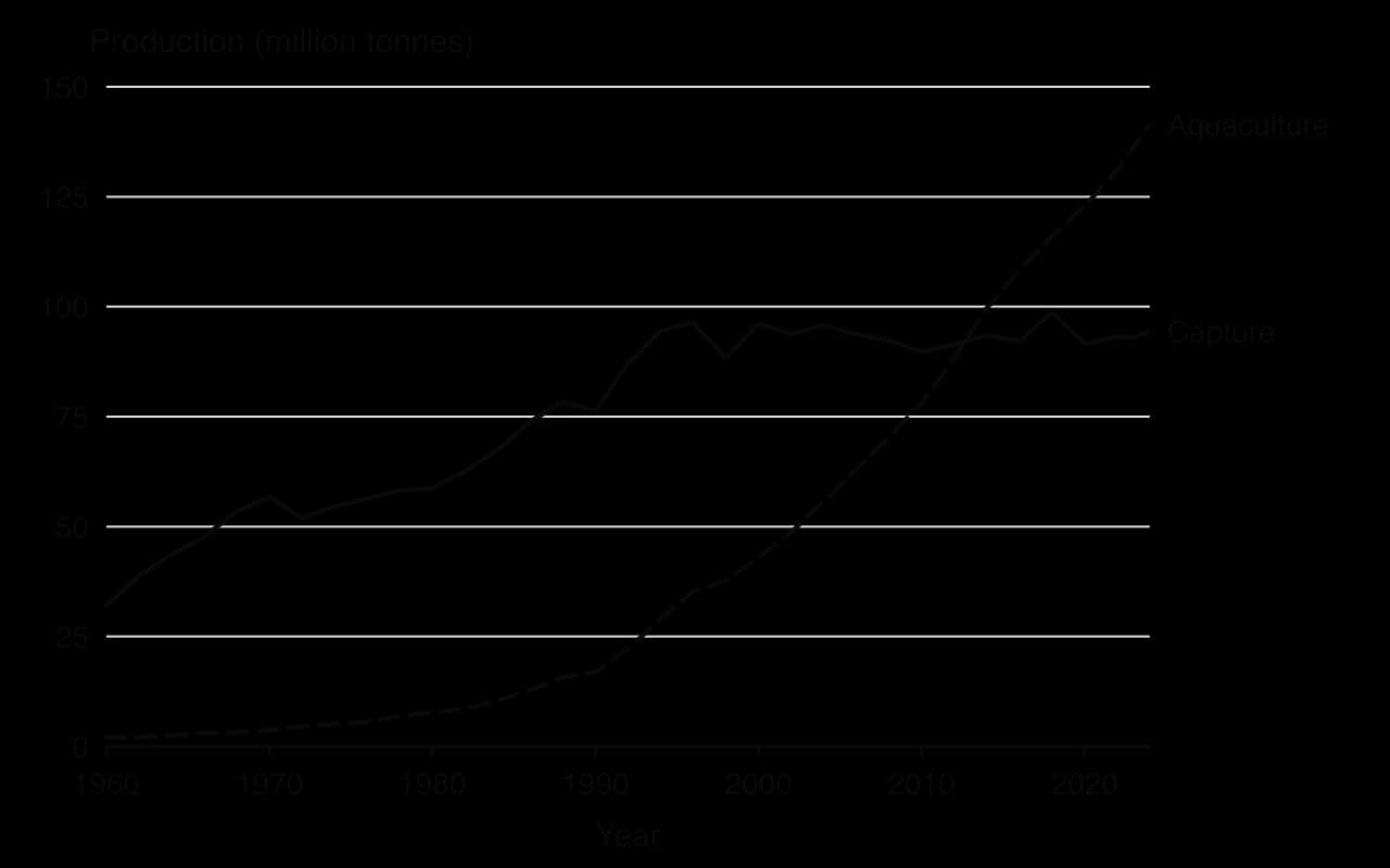
The chart shows two distinct trends. World capture production rose from about 32 million tonnes in 1960 to over 90 million tonnes by the mid-1990s and has stayed close to that level since, peaking at 98.7 million tonnes in 2018. Aquaculture grew from about 2 million tonnes in 1960 to 141 million tonnes in 2024, rising by about 8% a year for several decades. About 89% of farmed aquatic animals are produced in Asia.
Overfishing occurs when fish are caught faster than the stock can replace them by reproduction and growth, so the stock shrinks. The FAO estimates that the share of assessed stocks fished at biologically unsustainable levels rose from 10% in 1974 to 33.1% in 2015, and that only 62.4% of assessed stocks were within sustainable levels in 2023, so that about 38% were overfished.
Technology: factory ships that process and freeze catches at sea, sonar and satellite positioning to find shoals, and gear such as bottom trawls and longlines tens of kilometres long.
Subsidies: government payments for fuel and boats keep fleets fishing even when stocks are too low to be profitable.
Open access: where nobody owns the fish, each boat has an incentive to catch as much as possible before others do (the tragedy of the commons).
Illegal, unreported and unregulated fishing (IUU fishing): estimated at 11–26 million tonnes a year, or 14–33% of the reported world catch, and costing legal economies US$10–23 billion a year.
Bycatch: unwanted species or undersized fish caught by accident, including dolphins, turtles, sharks and seabirds, which are often thrown back dead.
A stock collapse is a sudden fall in a fish stock to a small fraction of its former size, after which it may not recover even if fishing stops. For 500 years the cod of the Grand Banks off Newfoundland, Canada, supported fishing communities. Factory trawlers from the 1960s caught far more than the stock could replace.
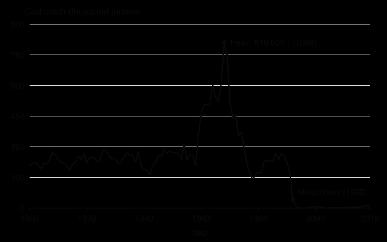
The chart shows that the catch roughly tripled within a decade of the trawlers’ arrival and fell by more than 80% between 1968 and 1978. Canada’s 200-nautical-mile zone, declared in 1977, removed most foreign fleets and catches recovered a little in the 1980s, but quotas were set too high on optimistic stock estimates, and the stock collapsed in 1992.
In 1992 northern cod fell to about 1% of historic levels. Canada declared a moratorium on fishing; about 37,000 fishers and plant workers lost their jobs in the largest industrial closure in Canadian history. A decade later the cod had still not returned: the ecosystem had changed, with smaller fish, crab and shrimp taking their place. Commercial fishing reopened only in 2024, with a total allowable catch of 18,000 tonnes.
Overfishing also changes whole food webs. When fleets remove large predators such as cod and tuna, they move on to smaller species lower in the food chain, a process described as “fishing down the food web”.
Industrial whaling in the twentieth century reduced many whale species to a small fraction of their former numbers. In 1982 the International Whaling Commission agreed a whaling moratorium, a pause on all commercial whaling, which took effect in 1986. Several species, such as humpback whales, have since recovered strongly. It has never been universal: Norway and Iceland objected and continue commercial whaling, and Japan left the commission in 2019 to resume commercial whaling in its own waters.
Maximum sustainable yield (MSY) is the largest catch that can be taken from a stock year after year without reducing its size. A stock grows fastest when it is at a medium size: a very small stock has too few breeding fish, while a very large stock is limited by food and space. Fishing to keep the stock near that medium size gives the highest long-term catch.
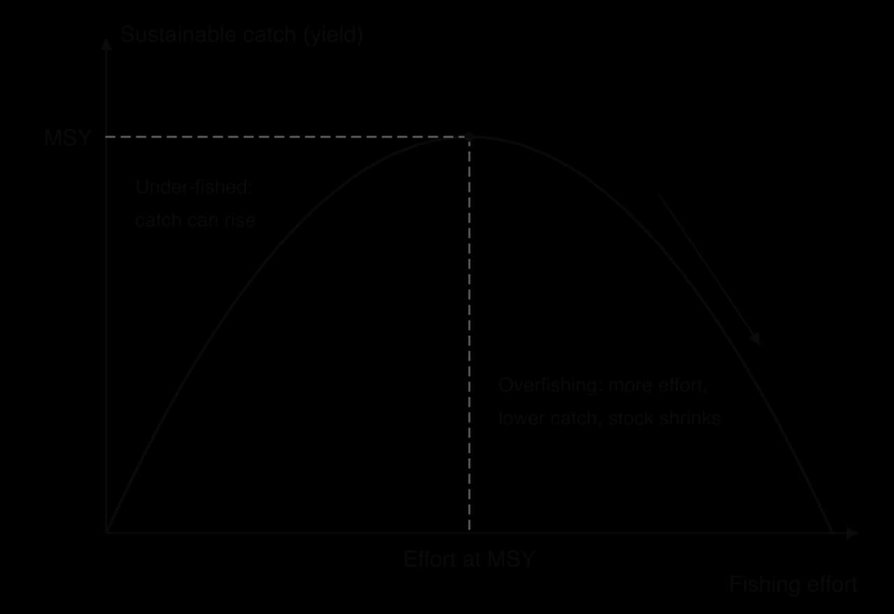
MSY is the benchmark used by the EU, the United States and many international fisheries bodies, but it has limits. It treats each species separately, ignoring predators, prey and bycatch; it assumes stock sizes are known accurately, when estimates are often uncertain; and it ignores natural variations such as the El Niño events that cut Peru’s anchoveta stocks. Many scientists therefore recommend fishing below MSY as a safety margin.
Aquaculture now supplies most of the world’s aquatic food and has eased pressure on some wild stocks. It ranges from carp ponds in Asia and oyster and mussel farms on ropes to salmon in sea cages in Norway, Scotland and Chile, and shrimp ponds in Southeast Asia and Latin America.
Its viability depends on what is farmed and how:
Feed: carnivorous species such as salmon are fed fishmeal and fish oil made partly from wild fish such as anchoveta, so salmon farming still depends on capture fisheries.
Pollution: uneaten food, faeces and chemicals from cages enrich the water and can cause algal blooms and eutrophication.
Disease and parasites: crowded fish spread disease and sea lice to wild salmon nearby, and farmed fish escape and breed with wild stocks.
Habitat loss: shrimp ponds have replaced large areas of mangrove in Asia and Latin America.
Better practice: filter-feeding shellfish and seaweed need no feed and clean the water; integrated multi-trophic aquaculture farms fish, shellfish and seaweed together so the waste of one species feeds another.
Marine protected areas (MPAs) restrict fishing and other activities. Where fishing is banned completely, in no-take zones, fish live longer and grow larger, and larger females produce far more eggs. Young and adult fish then spill over into surrounding waters, so catches near a well-enforced reserve can rise.
The Kunming–Montreal Global Biodiversity Framework of 2022 set the “30x30” target of protecting 30% of land and sea by 2030; by 2025 less than a tenth of the ocean was protected. The High Seas Treaty (the BBNJ Agreement), adopted in 2023 and in force from January 2026 after 60 ratifications, for the first time allows MPAs to be created on the high seas.
MPAs work only if they are large enough, well placed and enforced. Many are “paper parks” with no patrols, and fishing simply moves to their edges. Small-scale fishers can lose their grounds unless they help design the zones.
A total allowable catch (TAC) is the maximum amount of a species that may be caught from a stock in a year, set by scientists and governments. The TAC is then divided into a fishing quota for each country, fleet or boat. Under individual transferable quotas (ITQs), each fishing business holds a share of the TAC that it can buy, sell or lease.
ITQs give fishers a lasting stake in the stock: the healthier the stock, the more their share is worth, so there is less incentive to race for fish. Iceland introduced cod quotas in 1984 and made them transferable in 1990, and New Zealand’s quota management system began in 1986; both are cited as successes.
But quotas tend to concentrate in the hands of large companies, and small fishing villages can lose their rights when local owners sell. In Peru, individual vessel quotas for anchoveta from 2008 ended a race to fish that had left the fleet far larger than needed.
The EU’s Common Fisheries Policy sets national quotas each year; to stop discards of over-quota fish, most catches must now be landed and counted.
Eco-labels such as the Marine Stewardship Council (MSC) certify fisheries that meet standards for stock health and management, using consumer and retailer choice to reward good practice. Most certified catch, however, comes from large fisheries in high-income countries that can afford assessment.
Alternative | Strengths | Weaknesses | Works best where |
|---|---|---|---|
Aquaculture | Most of world supply; growth without wild catch; jobs in rural Asia | Feed from wild fish, pollution, disease, mangrove loss | Herbivorous fish, shellfish and seaweed; good regulation |
MPAs and no-take zones | Stocks and biodiversity recover; spillover raises nearby catches | Needs enforcement; fishing displaced; local users may lose | Large, well-enforced areas designed with fishers |
Quotas (TAC, ITQs) | Directly limit catch; ITQs end the race to fish | Depend on accurate science; discards; quota concentration | Single-species fisheries in states with strong institutions |
Certification | Market reward for good practice | Costly for small fisheries; limited reach | Export fisheries selling to high-income markets |
Whaling moratorium | Several whale species recovered | Not universal; objections and exemptions | Slow-breeding species with few hunting states |
No single alternative is enough on its own. Quotas set the overall limit, protected areas allow stocks to rebuild and protect habitats, and aquaculture adds supply, but each depends on enforcement and on fair treatment of small-scale fishers. Fisheries are improving where strong science, enforcement and clear rights combine, as in Iceland and New Zealand, and declining where these are weak, as on the high seas.
Ocean pollution is the introduction by people of substances or energy into the sea that harm marine life, human health or the use of the sea. Most of it comes from land, through rivers, sewers and the air, rather than from ships. Because ocean currents carry pollutants across borders, much ocean pollution is transboundary pollution, released in one country and harming others.
Radioactive waste is material that emits ionising radiation, from nuclear power, fuel reprocessing, weapons programmes and medicine. Between the 1940s and the 1980s several countries dumped drums of radioactive waste into the deep ocean. The London Convention of 1972 (in force from 1975), the main global treaty on dumping waste at sea, was amended in 1993 to ban the dumping of all radioactive waste.
Discharges from land were not covered by the dumping ban. The reprocessing plants at Sellafield in England and La Hague in France have discharged low-level radioactive effluent into the sea through pipelines for decades; Sellafield’s discharges peaked in 1975. Pressure from Ireland and Norway and the regional OSPAR Convention led to treatment plants that cut discharges sharply.
The most contested recent case is Fukushima Daiichi in Japan. After the 2011 tsunami destroyed the plant’s cooling systems, water used to cool the melted fuel became contaminated. It is treated to remove most radioactive elements except tritium, which cannot be separated from water, and over a million tonnes were stored in tanks. On 24 August 2023 Japan began releasing the treated water into the Pacific, diluted to 1,500 becquerels of tritium per litre or less, a process expected to take 30 years or more.
Stakeholder | Position on the Fukushima discharge |
|---|---|
Government of Japan and TEPCO (the operator) | Storage space is running out; diluted tritium is within international safety standards; monitoring shows no elevated levels in nearby waters |
International Atomic Energy Agency (IAEA) | The plan is consistent with international safety standards, but the decision is Japan’s own |
China, Hong Kong and Macau | Opposed the release and banned imports of Japanese seafood from some or all regions |
South Korea | Kept its ban on seafood from waters near Fukushima; surveys found over 80% of the public opposed the release |
Japanese fishers | Feared that buyers would shun their catch whatever the science, after years of recovery from 2011 |
The case shows the strengths and weaknesses of current controls. International standards and independent monitoring give a scientific basis for decisions, but no global body can stop a state releasing treated water from its own coast, and public trust depends on perception as much as on measurement.
Large tanker and platform spills, such as Deepwater Horizon (2010) and the Exxon Valdez, which ran aground in Alaska in 1989 and spilled about 37,000 tonnes of crude oil, attract the most attention. However, most oil entering the sea comes from routine sources: runoff from land and rivers, washing out of ships’ tanks, and leaks from engines and pipelines. Oil smothers seabirds and marine mammals, poisons shellfish and fish eggs, coats saltmarshes and mangroves, and closes fisheries and beaches.
Strategies work at several scales:
MARPOL, the International Convention for the Prevention of Pollution from Ships (1973, modified in 1978 and in force from 1983), sets limits on oil discharges from ships and requires equipment to separate oil from water. By 2018, 156 states, whose ships make up over 99% of world shipping tonnage, were parties.
Double hulls. After the Exxon Valdez, the US Oil Pollution Act of 1990 required new tankers in US waters to have double hulls, and the International Maritime Organization later phased out single-hull tankers worldwide.
Liability. Polluters, or international compensation funds, must pay for clean-up and damage.
Clean-up: floating booms contain oil; skimmers lift it off the surface; dispersants break it into droplets; burning removes it; bioremediation encourages bacteria to break it down. All are partial: in rough seas booms fail, dispersants move oil into the water column rather than removing it, and burning pollutes the air.
Marine plastic is plastic debris in the oceans, from large items such as bottles, bags and fishing nets to fragments too small to see. About 80% is thought to come from land, washed in by rivers or blown from coasts, and 20% from boats, fishing and aquaculture. Plastic breaks up in sunlight and waves but does not biodegrade, so it accumulates.
A microplastic is a piece of plastic less than 5 mm across. Primary microplastics are made small, such as microbeads in cosmetics and fibres shed from synthetic clothing and tyres; secondary microplastics form when larger items break down. They are eaten by plankton, shellfish and fish and so enter food chains, and they carry toxic chemicals absorbed from seawater.
Floating plastic is carried by surface currents into the centres of the subtropical gyres, where it collects in a garbage patch. The Great Pacific Garbage Patch, between Hawaii and California, was estimated in 2018 to cover about 1.6 million km² and hold 45,000–129,000 tonnes of plastic in about 1.8 trillion pieces. Microplastics make up 94% of the pieces, but 92% of the mass is larger objects, and nearly half the mass is discarded fishing nets. It is not a solid island but a thin soup of fragments over a vast area.
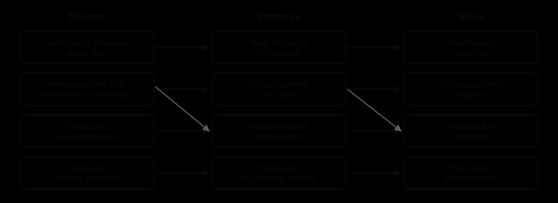
Plastic harms marine life through entanglement in lost nets (ghost fishing), ingestion by seabirds and turtles, and toxicity, and it damages tourism and fishing.
Local: beach and river clean-ups; charges and bans on plastic bags, with Kenya’s 2017 bag ban among the strictest; deposit-return schemes that pay people to return bottles and cans.
National: bans on microbeads in cosmetics (the United States in 2015, the United Kingdom in 2018); bans on single-use plastic items; better waste collection and recycling.
Regional and global: MARPOL Annex V, in force since 1988, bans ships from dumping plastics at sea; amendments to the Basel Convention in 2019 require consent before most plastic waste is exported; in March 2022 the UN Environment Assembly agreed to negotiate a legally binding global plastics treaty.
Technology: The Ocean Cleanup, a Dutch non-profit founded in 2013, uses floating barriers in the Great Pacific Garbage Patch and “Interceptor” barges at the mouths of polluted rivers.
The global treaty shows the difficulty of managing a global problem. Negotiations were meant to end in 2024, but at sessions in Busan (2024) and Geneva (August 2025) states could not agree. A majority, led by a High Ambition Coalition of states, wanted limits on plastic production; a minority of oil- and petrochemical-producing states wanted a treaty focused only on waste management. Clean-up projects, meanwhile, can remove only a tiny fraction of the plastic already in the sea, and none of the microplastics.
Strategy | Scale | Strengths | Weaknesses |
|---|---|---|---|
London Convention ban on radioactive dumping (1993) | Global | Ended deliberate dumping at sea | Does not cover discharges from land, such as Fukushima’s |
MARPOL and double hulls | Global and national | Large fall in oil from ships and tanker spills | Depends on flag states enforcing it; does not cover land-based oil |
Oil spill clean-up | Local | Protects key coasts quickly | Recovers only part of the oil; dispersants add toxicity |
Bag bans and deposit schemes | Local and national | Cheap, visible, change behaviour | Small share of total plastic; uneven enforcement |
Global plastics treaty | Global | Could limit production at the source | No agreement by 2025; producer states resist |
Ocean clean-up technology | Local to regional | Removes large debris; raises awareness | Tiny fraction removed; cannot catch microplastics |
Prevention at the source is more effective than clean-up, because pollution is costly and often impossible to remove once it is spread through the ocean. The most successful strategies, such as MARPOL and the dumping bans, targeted a small number of identifiable polluters (shipowners) under clear rules. Plastic is harder because its sources are billions of products and people, the benefits of plastic production are concentrated in a few states, and the costs are spread across the global commons.
The strategic value of an ocean area is its importance to a state’s security, economy and power, beyond the value of the resources in it. The oceans carry over 80% of world trade by volume, almost all intercontinental internet traffic through undersea cables, and the navies that allow powerful states to project force far from home. Control of key sea areas has therefore been a goal of great powers for centuries, and it underlies many current disputes.
Trade routes: container ships and tankers follow a small number of routes between Asia, Europe, the Gulf and the Americas.
Naval power: the ability to keep sea lanes open, or to close them to rivals, is a form of hard power.
Undersea cables and pipelines: hundreds of cables carry data and electricity; damage to them, accidental or deliberate, can cut countries off.
Resources and EEZs: every island or rock a state controls can extend its territorial sea and, if it is an island in law, its EEZ.
A chokepoint is a narrow passage on a major trade route, such as a strait or canal, through which a large share of shipping must pass. Because there are few alternatives, a blockage by an accident, war, piracy or drought can delay trade worldwide and raise prices.
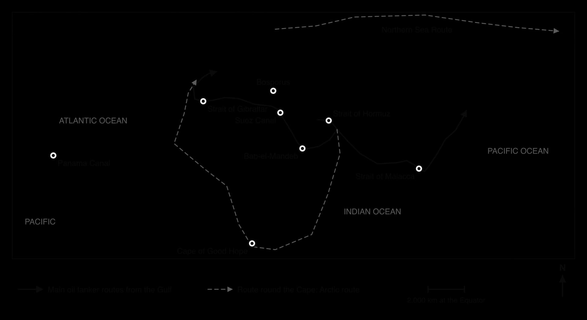
Choke point | Location | Importance | Recent event |
|---|---|---|---|
Strait of Hormuz | Between Iran and Oman, 26.6° N 56.5° E | Only sea exit from the Persian Gulf; about 25% of seaborne oil trade and 20% of LNG (2023–2025) | Largely blocked by Iran from 28 February 2026, during the war between Iran and the United States and Israel; Brent crude passed US$100 a barrel on 8 March |
Strait of Malacca | Between Malaysia and Sumatra (Indonesia), about 2.5° N 101° E | Busiest strait, carrying about 25% of traded goods; over 35% of seaborne oil (2024) | China’s dependence on it was called the “Malacca dilemma” in 2003 |
Bab-el-Mandeb | Between Yemen and Djibouti, 12.6° N 43.4° E | Entrance to the Red Sea and Suez route; about 10% of world trade | Houthi attacks on shipping from 19 November 2023: at least 30 ships damaged and four sunk; many ships rerouted round Africa |
Suez Canal | Egypt, about 30.5° N 32.5° E | Links the Mediterranean and Red Sea; about 12% of world trade (2021) | The container ship Ever Given blocked it from 23 to 29 March 2021; at least 369 ships queued |
Panama Canal | Panama, 9° N 79.7° W | Links the Atlantic and Pacific; its locks use fresh water from Gatun Lake | El Niño droughts cut daily transits from 36 to 22 in December 2023, and to 32 in September 2026 |
Bosporus and Dardanelles | Türkiye, 41° N 29° E | Only route between the Black Sea and the Mediterranean | Under the Montreux Convention (1936), Türkiye closed the straits to the warships of Russia and Ukraine in 2022 |
Northern Sea Route | Along Russia’s Arctic coast | Shorter route between Europe and East Asia as sea ice retreats | Growing use, but seasonal and controlled by Russia |
Sources: Wikipedia articles on each strait and canal, citing the US Energy Information Administration, ACLED and the Panama Canal Authority (accessed October 2026).
The crisis in the Strait of Hormuz in 2026 shows how much depends on a single choke point. Ship-tracking data showed traffic falling by about 70% as soon as Iran warned ships away on 28 February, and later to almost nothing; on 21 April the International Maritime Organization reported about 20,000 seafarers and 2,000 ships stranded in the Gulf.
Brent crude passed US$100 a barrel on 8 March and peaked at about US$126, and the closure was widely described as the largest disruption to world oil supply since the 1970s. A ceasefire on 8 April and a US–Iran memorandum on 17 June did not end restrictions, and Iran declared the strait closed again on 20 June. Importing states in Asia and Europe, producers inside the Gulf and shipping companies were all affected, while producers outside the Gulf gained from higher prices.
Islands are contested because of what they bring with them: a territorial sea, possibly an EEZ and continental shelf, fishing grounds, seabed resources and positions for military bases. Several disputes remain unresolved:
Senkaku/Diaoyu Islands (East China Sea): administered by Japan and claimed by China and Taiwan; tension rose after the Japanese government bought three of the islands from their private owner in September 2012.
Kuril Islands / Northern Territories: occupied by the Soviet Union in 1945 and administered by Russia, claimed in part by Japan; the dispute has prevented a formal peace treaty between the two states.
Falkland Islands / Islas Malvinas (South Atlantic): a British overseas territory claimed by Argentina, which invaded in 1982 and was defeated in a ten-week war; the surrounding waters hold fisheries and possible oil.
Spratly and Paracel Islands (South China Sea): the subject of the case study.
An artificial island is land built on a reef, shoal or sandbank by dredging and piling up sediment, or by construction. Under UNCLOS, an artificial island generates no territorial sea or EEZ of its own, but building one can give a state a runway, harbour and permanent presence that strengthen its control in practice.
A maritime dispute is a disagreement between states over the boundaries of maritime zones, the ownership of islands and features, or the right to use the sea and its resources. Such disputes can be settled by negotiation, by courts such as the International Tribunal for the Law of the Sea, or by arbitration under UNCLOS, but only if the states involved accept the outcome.
A global commons is a resource or area that lies outside the jurisdiction of any single state and is shared by all, such as the atmosphere, Antarctica, outer space and the high seas. The high seas are all the ocean beyond any state’s EEZ, about two-thirds of the ocean’s area. There, every state enjoys freedom of navigation, the right of its ships to sail and fly without interference, as well as freedom to fish, lay cables and carry out research.
The difficulty of managing a commons is described by the tragedy of the commons, an idea popularised by Garrett Hardin in 1968. When a resource is open to everyone but owned by no one, each user gains the full benefit of taking more, while the cost of over-use is shared by all, so the resource is over-used until it is degraded. On the high seas this explains overfishing of tuna and sharks by distant-water fleets, and the slow progress on plastic pollution: each state benefits from producing or dumping, while the harm is shared. A free rider benefits from others’ restraint without restraining itself.
Commons can be managed, however, through shared rules with enforcement, as in regional fisheries organisations that set tuna quotas, the global whaling moratorium, MARPOL and the new High Seas Treaty, and through clearer rights, as the creation of 200 nm EEZs did for coastal fish.
Stakeholder | Perspective on the oceans as a global commons |
|---|---|
Coastal states with large EEZs (e.g. Kiribati, France) | Favour national control of resources; want income from licences and protection from foreign fleets |
Great powers and naval states (e.g. the United States, China) | Insist on freedom of navigation for their navies and trade, while competing for influence and resources |
Distant-water fishing states (e.g. China, Spain, Japan, South Korea) | Favour access to the high seas and to other states’ EEZs through licences |
Small island and low-income states | Want a fair share of benefits from the commons, such as seabed revenue and genetic resources, and protection from pollution they did not cause |
Conservation organisations | Want large high-seas protected areas, a deep-sea mining pause and limits on plastic production |
The South China Sea is a marginal sea of the western Pacific covering about 3.5 million km², bounded by southern China and Taiwan to the north, Vietnam to the west, the Philippines to the east, and Malaysia, Brunei and Indonesia to the south. It contains hundreds of small islands, reefs, shoals and banks, grouped mainly in the Paracel Islands in the north-west and the Spratly Islands in the south-east, plus Scarborough Shoal off the Philippine island of Luzon.
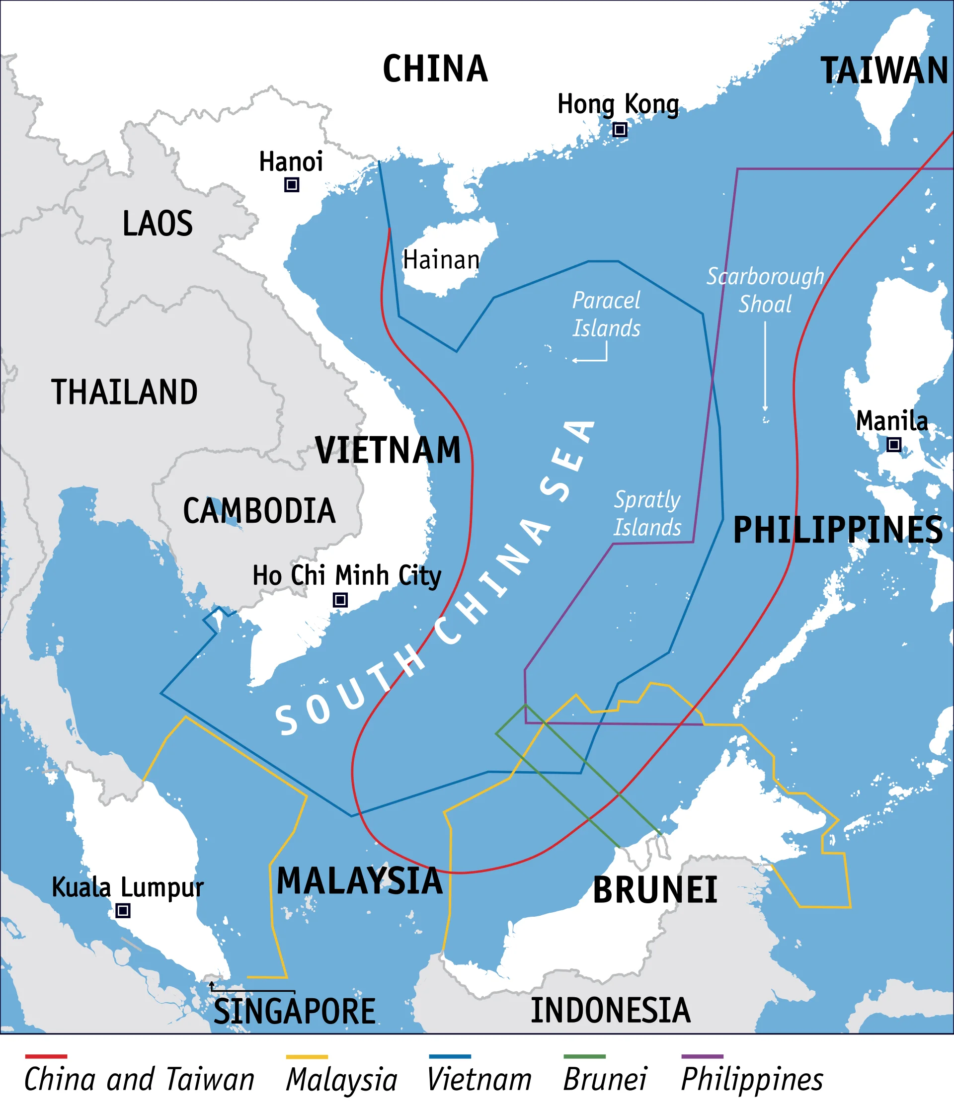
Trade: about US$3.4 trillion of the world’s US$16 trillion of seaborne trade passed through it in 2016; in 2023 about 10 billion barrels of oil and petroleum products and 34% of world trade in liquefied natural gas crossed it. About 80% of China’s energy imports pass through it.
Fisheries: the Western Central Pacific supplied 14% of the world’s commercial catch in 2010, and the sea’s fish are an important source of food and income for coastal communities in every claimant state.
Oil and gas: the US Energy Information Administration estimated about 11 billion barrels of oil and 190 trillion cubic feet of gas, mostly near undisputed coasts rather than under the disputed islands.
Strategic position: control of the sea gives access between the Pacific and Indian Oceans through the Strait of Malacca and protects China’s southern coast and naval bases on Hainan.
China and Taiwan claim most of the sea within the nine-dash line, a U-shaped line first published by the Republic of China in 1947, based on historic use. Vietnam claims the Paracel and Spratly Islands, also on historic grounds. The Philippines, Malaysia and Brunei claim parts of the Spratlys and the waters within their EEZs, based on UNCLOS and proximity. China has occupied all of the Paracels since 1974, when it took the remaining islands from South Vietnam by force, and the two states fought near Johnson Reef in the Spratlys in 1988.
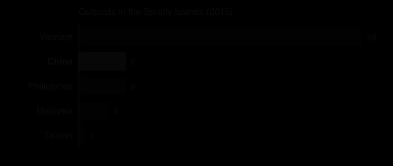
Claimants have occupied features by building outposts on them. By 2015 Vietnam held 48 outposts in the Spratlys, China 8, the Philippines 8, Malaysia 5 and Taiwan 1 (Itu Aba, the largest natural island). The number of outposts is only part of the picture: from 2014 to 2016 China turned seven reefs into artificial islands, reclaiming around 13 km² by 2023, far more than all other claimants together. Fiery Cross Reef became an island of 274 ha with a runway, hangars and missile shelters.
In 2013 the Philippines brought a case against China under UNCLOS, heard by an arbitral tribunal with the Permanent Court of Arbitration as registry. China refused to take part. On 12 July 2016 the tribunal ruled largely for the Philippines:
China’s claims to historic rights within the nine-dash line have no lawful effect beyond the zones allowed by UNCLOS.
None of the high-tide features in the Spratlys, including Itu Aba, can sustain human habitation of its own, so all are rocks in law and generate no EEZ.
Mischief Reef and Second Thomas Shoal are low-tide elevations within the Philippines’ EEZ, so China’s construction on Mischief Reef breached the Philippines’ sovereign rights.
China’s island building caused severe harm to coral reefs, breaching its duty to protect the marine environment.
The tribunal did not decide who owns the islands, only what zones they can generate. China and Taiwan rejected the award. By November 2023, 26 governments had called for it to be respected, 17 had noted it without calling for compliance, and eight had rejected it. With no body able to enforce the ruling, China has continued to occupy and build on the features.
Scarborough Shoal: after a stand-off between Chinese and Philippine vessels from April 2012, China took control of access to the shoal, and Filipino fishers who had worked there for generations were forced to fish further away at higher cost. Water-cannon confrontations continued, and in August 2025 a China Coast Guard ship chasing a Philippine vessel collided with a Chinese navy destroyer. In September 2025 China declared part of the shoal a national nature reserve.
Second Thomas Shoal: in 1999 the Philippines deliberately grounded the old warship BRP Sierra Madre on the reef and has kept a small garrison of marines on board ever since. China Coast Guard vessels have blocked resupply missions with water cannon (November 2021 and August 2023) and collisions (October 2023). After a clash in June 2024, the two states reached a “provisional arrangement” on resupply in July 2024.
 YouTube
Actor | Position and interests | Main means of power |
|---|---|---|
China | Historic rights within the nine-dash line; security of its coast and trade; resources | Coast guard and maritime militia, artificial islands, navy, economic ties |
Philippines | Its EEZ and fishing rights as confirmed by the 2016 award | International law, alliance with the United States, publicity of incidents |
Vietnam | Sovereignty over the Paracels and Spratlys; offshore oil | Outposts, its own reclamation, diplomacy |
Malaysia and Brunei | Oil and gas in their EEZs | Quiet diplomacy, continued drilling |
Taiwan | Shares the historic claim; holds Itu Aba | Occupation of the largest natural island |
United States and allies (Japan, Australia, the UK, France) | Freedom of navigation and a rules-based order; alliances | Freedom of navigation operations by warships within 12 nm of artificial islands since October 2015 |
ASEAN | Regional stability; a code of conduct | Negotiation, divided by members’ ties to China |
Fishers of all claimant states | Access to traditional grounds | Little power; most directly harmed by stand-offs |
The South China Sea shows the limits of UNCLOS when a powerful state rejects it. The 2016 tribunal upheld the Philippines’ rights in its EEZ, but China’s artificial islands and coast guard patrols give it control of much of the disputed area in practice.
Power at sea is a mix of hard power (ships, bases), legal arguments and economic influence, and smaller states rely on international law and alliances to balance a larger neighbour. The likely futures range from a negotiated code of conduct and joint development of resources to continued low-level confrontation, with the risk that an incident at a shoal could draw in the United States through its defence treaty with the Philippines.
Why has the 2016 arbitral award not ended the dispute?
To what extent is the South China Sea dispute about resources rather than strategic power?
Which groups of people lose most from the dispute, and why?
Sources: Wikipedia articles South China Sea, South China Sea Arbitration, Territorial disputes in the South China Sea, Scarborough Shoal, Second Thomas Shoal and Fiery Cross Reef, citing the Permanent Court of Arbitration (2016), US EIA (2013), CSIS AMTI and the US Department of Defense (accessed October 2026).
The table shows world fish production (Our World in Data, based on FAO data; totals include aquatic plants).
Year | Capture (million tonnes) | Aquaculture (million tonnes) |
|---|---|---|
1990 | 76.4 | 17.0 |
2000 | 96.2 | 43.1 |
2010 | 89.7 | 78.1 |
2020 | 91.6 | 122.8 |
Demand for offshore oil, gas, seabed minerals and sand is rising because of energy demand, depleted land reserves, new technology and the energy transition.
Extraction brings revenue and energy security but risks oil spills, as from Deepwater Horizon in 2010, and irreversible damage to deep-sea ecosystems; the ISA has not agreed rules for commercial seabed mining.
Capture fisheries have been roughly flat at about 90–95 million tonnes since the 1990s, while aquaculture has grown to supply most aquatic food.
Overfishing, driven by technology, subsidies, open access and IUU fishing, has collapsed stocks such as Grand Banks cod.
Aquaculture, protected areas, quotas and certification are viable alternatives only when well regulated and enforced; MSY is a maximum, not a safe target.
Pollution controls work best against identifiable sources (MARPOL, the London Convention); plastic is harder because its sources are many and the global treaty has stalled.
Choke points such as Hormuz, Malacca, Bab-el-Mandeb, Suez and Panama give the oceans strategic value and make world trade vulnerable to war, accidents and drought.
The high seas are a global commons exposed to the tragedy of the commons; shared rules such as the High Seas Treaty can reduce it.
In the South China Sea, the 2016 arbitral award favoured the Philippines, but China’s island building and coast guard presence control the facts on the water.
I can describe the main abiotic resources of the oceans and explain why demand for them is rising.
I can evaluate the consequences of offshore oil and gas extraction and deep-sea mining, with named examples.
I can describe trends in capture fisheries and aquaculture using data, and determine percentage changes.
I can explain overfishing, stock collapse and maximum sustainable yield.
I can evaluate aquaculture, protected areas and quotas as alternatives to overfishing.
I can evaluate local and global strategies for radioactive, oil and plastic pollution.
I can explain the strategic value of oceans and locate the main choke points.
I can discuss the oceans as a global commons and the tragedy of the commons.
I can examine the South China Sea dispute from the perspectives of different states.
Social consequences: impacts on fishing communities and coastal tourism; risk of the “resource curse”, corruption and inequality in states with weak governance.
Geopolitical consequences: offshore hydrocarbons raise the value of disputed areas and islands, eg the South China Sea, the eastern Mediterranean (Cyprus, Türkiye) and the Arctic, increasing the risk of international conflict.
Good answers may be well structured (AO4) and may additionally offer a critical evaluation (AO3) which examines whether causes such as technology or price are the more important, recognizing that they interact (higher prices fund new technology). Another approach might be to weigh short-term economic benefits against long-term environmental costs and climate change (possibilities), or to contrast consequences for different places and stakeholders, such as national governments, transnational corporations (TNCs), local fishers and future generations (perspectives, power). Some responses may consider how the energy transition could reduce future demand.
For 5–6 marks, expect some weakly-evidenced outlining of causes and/or consequences of offshore oil and gas exploitation.
For 7–8 marks, expect a structured account which includes:
either well-evidenced explanation of both causes and consequences, supported by located examples
or a discursive conclusion (or on-going evaluation) grounded in geographical concepts and/or perspectives.
For 9–10 marks, expect both of these traits.
NB. Maximum [4] if the answer focuses on biotic resources (eg fish) rather than oil and gas.
Marks | Level descriptor |
|---|---|
0 | The response does not reach a standard described by the descriptors below. |
1–2 | Too brief, lists unconnected information, not focused on the question and lacks structure. Knowledge is very general, with large gaps or errors; examples or case studies are missing or only listed. No analysis; terminology is missing or used incorrectly. |
3–4 | Too general, lacks detail, not focused on the question and largely unstructured. Outlines examples, statistics and facts, both relevant and irrelevant, with links to the question only listed. Basic terminology is used, with errors or inconsistently. No critical evaluation of evidence; any conclusion is irrelevant. |
5–6 | Partially addresses the question, with a narrow argument, an unsubstantiated conclusion and limited evaluation. Describes relevant supporting evidence (examples, case studies) and outlines links to the question. The argument repeats one point or covers only part of the question. Other perspectives, or strengths and weaknesses of evidence, are listed. |
7–8 | Addresses the whole question; the analysis is evaluated and the conclusion is relevant but lacks balance. Relevant evidence is described correctly and covers all the main points. The argument is clear but one-sided or unbalanced. Complex terminology is used correctly but not consistently. Other perspectives, or strengths and weaknesses of evidence, are described. |
9–10 | In-depth and specific to the question (topic and command term). Correct, relevant examples, statistics and detail are integrated and their link to the question explained. The argument is balanced, explaining complexity, exceptions and comparisons. Evaluation of evidence and perspectives is well developed, and the conclusion is balanced and aligned with the evidence. Logically structured and easy to follow. |
Examine the view that the environmental costs of deep-sea mining are likely to outweigh its economic benefits.
10 marks
Examine the relative importance of technological change and growing global demand in explaining the increasing exploitation of abiotic ocean resources.
10 marks