
Evaluate hard and soft coastal defences, managed retreat and planning tools, explain land-use conflicts, reef and mangrove management and maritime zones, and judge who gains and loses, with Jakarta as the case study.
Each is in the Geography glossary, with every other term in the subject.
The line, normally the low-water line along the coast, from which a state's territorial sea, EEZ and other maritime zones are measured.
The artificial addition of sand or shingle to a beach, usually dredged from offshore, to make it higher and wider so that it absorbs more wave energy.
Carbon captured and stored by coastal and marine ecosystems, especially mangroves, saltmarshes and seagrass meadows, mostly in their waterlogged soils.
The use of measures such as regrading, drainage, toe protection, rock bolts and vegetation to reduce erosion and mass movement on a cliff.
The planning and use of strategies to reduce coastal erosion and flood risk and to balance the competing human and environmental uses of a coastline.
The division of a coastline and its waters into zones in which particular uses, such as ports, tourism or conservation, are permitted or banned.
A grid that compares each pair of land uses or activities in an area and shows whether they are compatible, in conflict, or compatible only under certain conditions.
The belt of sea from 12 to 24 nautical miles from a state's baseline, in which the state may enforce its customs, tax, immigration and health laws.
Describe how the main hard engineering structures protect a coast from erosion and flooding, with their costs, lifespans and side effects.
Explain how soft engineering, cliff stabilisation and managed retreat work, and why each suits some coasts and not others.
Examine how coastal management decisions are made, using shoreline management plans, cost–benefit analysis and integrated coastal zone management.
Evaluate hard and soft approaches to coastal management from the perspectives of different stakeholders.
Explain why coastal land uses compete, using a conflict matrix and a named stakeholder example.
Discuss how coral reefs and mangrove swamps are valued, threatened and managed, with detailed examples of each.
Outline the maritime zones set by the United Nations Convention on the Law of the Sea and the rights a state holds in each.
Evaluate the outcomes of a coastal management decision for different groups of people, using the case study of Jakarta.
Coastal margins are the narrow strip where land and sea meet. They hold a large share of the world’s people, cities, ports and ecosystems, and they change constantly through erosion, deposition, storms and sea-level rise. Managing them means deciding which parts of the coast to defend, which to let change, and who pays.
The topic is about power and possibility. Defences protect some places and expose others, and the groups with money, legal rights and political voice usually decide which. Sea-level rise forces every coastal society to consider new possibilities, from higher walls to moving homes inland, or even moving a capital city.
68 exam-style questions on this subtopic, written in the style of the IB papers. The first has its markscheme open. Counted on
To what extent are the costs and benefits of exploiting abiotic ocean resources shared unequally between different places and people?
10 marks
Marks should be allocated according to the markbands.
Abiotic ocean resources include offshore oil and gas, seabed minerals, sand and gravel, and desalinated water. Costs may be environmental, economic or social; benefits may include profits, government revenue, jobs, energy and water security. “Places and people” allows answers to compare countries, regions, coastal communities, social groups, TNCs and generations. Credit either a mainly “unequal” or a mainly “equal” conclusion if it is supported.
Possible applied themes (AO2) demonstrating knowledge and understanding (AO1):
Under UNCLOS, coastal states control seabed resources in their EEZ (200 nautical miles) and extended continental shelf, so states with long coastlines and many islands gain most, while landlocked states gain little directly.
Profits often go to TNCs and shareholders in high-income countries, while local communities bear environmental risks, eg the Niger Delta, where offshore and onshore oil spills have damaged fisheries.
Deepwater Horizon (2010): BP paid tens of billions of US dollars in clean-up costs, fines and compensation, but fishers, shrimpers and tourism businesses on the Gulf coast of Louisiana and Alabama suffered losses that compensation did not fully cover.
Guyana: oil revenues since 2019 have greatly increased GDP and fund a sovereign wealth fund, but critics question the share of profit going to the ExxonMobil-led consortium and the country's exposure to spills.
Sand dredging to supply land reclamation in Singapore led to the loss of small islands and fishing grounds in Indonesia and Cambodia, which later restricted sand exports; the benefits went to the importing city-state.
With a free account, Augment remembers where you stopped and what you have practiced.
In law, the seabed and subsoil beyond a state's territorial sea to 200 nautical miles, or to the edge of the continental margin up to 350 nautical miles, over whose resources the state has rights.
The rebuilding or stabilising of sand dunes by planting marram grass, fencing, thatching and controlling access, so that they store sand and protect the land behind.
The area of sea up to 200 nautical miles from a state's baseline in which that state has sole rights to the natural resources of the water and seabed, while other states keep freedom of navigation.
A wire-mesh cage filled with stones, stacked to form a wall or slope that absorbs wave energy; a cheap but short-lived coastal defence.
A barrier built at right angles to the shoreline to trap sediment carried by longshore drift and so build up a wider beach.
The use of artificial structures such as sea walls, groynes and rock armour to control natural coastal processes and protect the land behind them.
A coastal management policy of keeping the shoreline in its present position by maintaining existing defences or building new ones.
The right of foreign ships to sail through a state's territorial sea without stopping, provided they do not threaten its peace, order or security.
An approach that plans and manages all the uses of a coastal area together, across land and sea and across sectors and levels of government, with the participation of all its stakeholders.
The creation of new land from the sea, a lake or a wetland by draining it or filling it with sand, rock or other material.
A salt-tolerant tree or shrub that grows in the intertidal zone of sheltered tropical and subtropical coasts; mangrove swamps are forests of these trees.
An area of sea or coast in which human activities such as fishing, mining or development are restricted by law to protect its ecosystems and resources.
A unit of distance used at sea and in maritime law, equal to 1.852 km and based on one minute of latitude.
A coastal management policy under which no investment is made in building or maintaining defences, so that natural processes are allowed to shape the coast.
An area of sea, usually within a marine protected area, in which all fishing and collecting of marine life is banned.
A barrier of rock or concrete built in the sea parallel to the coast, so that waves break and lose energy before they reach the shore.
An arrangement in which those who benefit from an ecosystem pay the people who manage it to keep it intact, for example through blue carbon credits.
Active intervention to help a damaged coral reef recover, for example by growing coral fragments in nurseries and transplanting them or stabilising rubble so corals can settle.
A sloping structure of concrete, stone, timber or rock placed at the foot of a cliff or back of a beach, on which waves run up and lose energy.
Large boulders piled at the foot of a cliff or sea wall so that waves break on them and lose energy before reaching the land.
A wall of concrete, stone or steel built along the coast to stop waves eroding or flooding the land behind it; a recurved sea wall has a curved top that deflects waves seaward.
A line a set distance inland from the shoreline, seaward of which new building is not permitted, so that development is kept out of areas likely to erode or flood.
A long-term plan for a stretch of coast, usually based on a sediment cell, that sets a management policy for each section of shoreline over the next 100 years.
Coastal management that works with natural processes by adding or restoring beaches, dunes, saltmarshes or mangroves that absorb wave energy, rather than building artificial structures.
The supreme and independent authority of a state over its territory, including its land, internal waters, territorial sea and the airspace above them.
A movable barrier across an estuary or channel that is closed when a storm surge or exceptionally high tide is forecast, to stop the sea flooding the land upstream.
The belt of sea up to 12 nautical miles from a state's baseline, over which the state has sovereignty, subject to the right of innocent passage of foreign ships.
The international treaty of 1982, in force since 1994, that defines the maritime zones of coastal states, their rights and duties in each, and the rules for the high seas and deep seabed.
Scope: The syllabus covers strategies for managing coastal erosion and flooding (including cliff stabilisation and managed retreat), conflicting land uses and conservation, the management of coral reefs and mangroves, and the sovereignty rights of states in territorial waters and exclusive economic zones. It asks for one case study of a coastal management decision and its actors (here, Jakarta), one case study of coastal stakeholders (here, the Gold Coast of Australia) and detailed examples of a reef and a mangrove system. Option B is one of seven options, of which SL students study two and HL students three.
Coastal management is the planning and action people take to reduce erosion and flood risk on a coast and to balance its different uses.
Coasts need managing because natural processes and dense human use meet there. Destructive waves erode cliffs, longshore drift moves sediment along the shore and storms push water inland as a storm surge, while homes, roads, ports and power stations stand at the water’s edge. About 40% of the world’s population lives in coastal zones, which make up less than 15% of the Earth’s land area.
Two different hazards are managed, and one strategy rarely deals with both equally well. Coastal erosion is the permanent loss of land as waves and weathering wear back cliffs and remove beach sediment; it is usually gradual, metres a year on soft rock. Coastal flooding is the temporary covering of low land by the sea, usually during a surge at high tide; it is sudden and can be deadly, as in the North Sea flood of 1953, which killed 307 people in the United Kingdom and over 1,800 in the Netherlands.
Coastal flood risk depends on the hazard, on exposure (the people and assets in its path) and on vulnerability (how easily they are harmed). A sea wall reduces the hazard, moving homes reduces exposure, and warnings and insurance reduce vulnerability. Good management usually combines all three.
Coastal sediment moves within sediment cells, lengths of coast in which sand and shingle are supplied, moved by longshore drift and deposited, with little exchange with neighbouring cells. Because the system is connected, a structure that traps sediment in one place starves the beaches downdrift of it, so protecting one stretch of coast can increase erosion on the next. For this reason coastal plans in many countries now treat the whole sediment cell, not one town’s seafront, as the unit of management.
Sea-level rise adds pressure everywhere. Global mean sea level rose by about 4.6 mm a year in 2013–2022, roughly twice the twentieth-century average, and where the land is also sinking the relative sea-level change is far faster. Every defence built today must cope with higher water and bigger waves in future, or be replaced.
Hard engineering uses built structures of concrete, rock, steel or timber to resist the energy of the sea. It is the traditional approach where valuable land lies behind the coast: town centres, ports, railways and power stations. It gives a high and predictable standard of protection, but it is expensive, needs maintenance, changes the look of the coast and often interferes with sediment movement.
Hard structures work in one of three ways: they reflect wave energy back out to sea (vertical walls), absorb it by making waves break over a rough or sloping surface (rock armour, revetments, gabions, breakwaters), or trap sediment so that a wider beach absorbs the waves (groynes).
A sea wall is a wall of concrete, stone or steel along the back of the beach that stops waves reaching the land. Many have a recurved lip that throws breaking waves back seaward. Reflected waves churn up the beach in front of the wall and carry sand offshore, so the beach level drops and the foot of the wall is exposed. This toe scour can undermine the wall unless it is protected with rock or deep foundations.
A revetment is a sloping structure of concrete, stone, timber or loose rock against the cliff foot or the back of the beach. Waves run up the slope and lose energy instead of slamming against a vertical face, so it causes less scour than a wall. Impermeable revetments are usually designed to last 30–50 years.
Rock armour (rip-rap) is a pile of large boulders, often hard rock brought from elsewhere, at the foot of a cliff or sea wall. The rough surface and the gaps between rocks break waves and absorb their energy. It is fairly cheap where rock is close by, but it looks out of place, blocks access and can be shifted by storms.
A gabion is a wire-mesh cage filled with stones, stacked as a wall or slope. Gabions are cheap and can use local stone, so they suit places where large rocks are unavailable or long-term protection is not justified, but the wire corrodes in salt water and on exposed coasts they may last only 5–10 years.
A groyne is a low wall of timber, rock or concrete built out from the shore at right angles to trap sediment moving by longshore drift. Sand builds up on the updrift side of each groyne, widening the beach, and a wide beach makes waves break and lose energy before they reach the land.

Groynes work by holding back sediment, so downdrift of the last groyne the beach is starved and erosion speeds up: the terminal groyne effect. At Mappleton on the Holderness coast of England, a £2 million scheme in 1991 built two rock groynes and a revetment to protect the village, where the till cliffs had been retreating by about 1.7 m a year between 1952 and 1989. The village was saved, but erosion increased on the cliffs immediately to the south, where the land was mostly farmland. The scheme was a trade-off: it protected one community by moving the cost downdrift to landowners who had no right to compensation, which is why shoreline management plans now judge schemes across a whole sediment cell rather than one frontage at a time.
An offshore breakwater is a barrier of rock or concrete built in the sea parallel to the coast, so that waves break on it before reaching the shore; sand often settles in the calmer water behind it. Breakwaters are expensive to build in open water, but they protect harbours and beaches without a wall on the shore itself; their main side effect is that the sand trapped behind them no longer moves downdrift.
Tetrapods, interlocking four-legged concrete blocks of several tonnes, armour many breakwaters and sea walls in Japan, the Mediterranean and India, because their legs lock together and leave gaps that absorb wave energy. On the Gold Coast of Australia, the submerged Narrowneck artificial reef works in the same way as a breakwater and holds sand on the beach.
Where a large city lies on an estuary, a storm surge barrier can close the mouth of the estuary when a surge is forecast and stay open the rest of the time for ships and river flow.
Thames Barrier, London (1982). Ten steel gates rotate up from the riverbed when high tides and surges threaten central London. It cost about £535 million and was designed against a 1-in-1,000-year surge to 2030. Expected to close two or three times a year, it made 221 flood defence closures by July 2026 and is planned to operate until about 2070.
Maeslantkering, Rotterdam (1997). Two floating gates, each 210 m long, swing across the 360 m wide channel to the Port of Rotterdam when a 3 m surge is forecast, decided entirely by computer. It cost €450 million, first closed for a storm on 8 November 2007, and completed the Delta Works built after the 1953 flood.
Barriers protect huge areas for a fraction of the damage they prevent, but they depend on accurate forecasts and will close more often as the sea rises.
Costs vary widely with exposure, materials and height, so the indicative ranges are used only for early comparisons of options.
Structure | Indicative cost (£ per metre, 2007 prices) | Typical life and maintenance | Main drawbacks |
|---|---|---|---|
Sea wall and impermeable revetment | 700–5,400 | Revetments 30–50 years; concrete walls poor after about 60 years unmaintained | Toe scour, lowers beach |
Rock armour | 1,350–6,000 | Long-lasting; rocks moved by storms need topping up | Unattractive, blocks access, rock often imported |
Gabions | 50–500 | Often 5–10 years on exposed coasts | Wire corrodes, cages burst |
Timber groynes | About 400–1,950 per metre of groyne, rising with height | Need regular repair; rock groynes last longer | Starve downdrift beaches |
Offshore breakwater | 1,750–4,300 | Long-lasting | Costly to build in water; can disrupt sediment flows |
Sources: Environment Agency, Cost estimation for coastal protection: summary of evidence (2015), using the Environment Agency unit cost database (2007 prices) and Crossman and Simm (2002).
Soft engineering works with natural processes instead of resisting them. It adds or restores beaches, dunes, saltmarshes and mangroves that absorb wave energy, so that the coast protects itself. Soft schemes are usually cheaper, look natural and can create habitat, but they need repeating or maintaining and give a less certain standard of protection than a wall.
Beach nourishment (beach replenishment) adds sand or shingle, usually dredged offshore, to a beach. A higher, wider beach absorbs more wave energy, protects the cliffs or wall behind it and keeps the beach attractive for tourism. Because waves and longshore drift keep moving the sediment, nourishment must be repeated, typically every few years.
In 2011 the Netherlands’ Sand Motor (Zandmotor) placed 21.5 million m³ of sand in a hook-shaped peninsula of 128 ha south of The Hague, for about €70 million. Instead of nourishing the beach every 3–5 years, it lets waves, wind and tides spread the sand along the coast for 20 years or more, disturbing the seabed less often. Beach reprofiling and shingle recycling move sediment already on the beach back to where it was eroded; they are cheap but add nothing to the system.
Dune regeneration rebuilds or stabilises dunes so they can store sand and block flooding: planting marram grass, fencing areas to keep people off, laying boardwalks, and thatching bare sand with brushwood to trap blown sand. Costs are very low, roughly £2–20 per metre for fencing or thatching, but dunes take years to recover and need space to move inland as the sea rises.
Healthy saltmarsh in front of a flood bank reduces wave height, so the bank can be lower and cheaper. Creating saltmarsh and replanting mangroves in the tropics are therefore treated as defences in their own right, often called nature-based solutions.
Many cliffs fail through wave erosion at the foot combined with mass movement higher up. Rain soaks into the rock, raises the water pressure in its pores and lubricates surfaces along which slumps and slides occur. Cliff stabilisation tackles both parts of the problem: toe protection with rock armour or a revetment, regrading the cliff to a gentler angle, drainage to let groundwater out, rock bolts and netting to hold loose blocks, and vegetation to bind the surface.
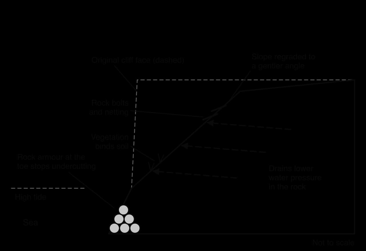
Stabilisation can secure cliff-top towns, but eroding cliffs are an important source of sediment for beaches and spits downdrift. Where they are stabilised that supply stops, and beaches further along may thin, so stabilising one cliff can raise erosion risk elsewhere in the sediment cell.
Holding the coastline in place everywhere is neither affordable nor, as the sea rises, possible. Managed retreat, called managed realignment in the United Kingdom, deliberately moves the line of defence inland, often by breaching an old embankment and building a new one further back. The land in between floods with the tide and becomes saltmarsh or mudflat, which absorbs wave energy and protects the new defence.
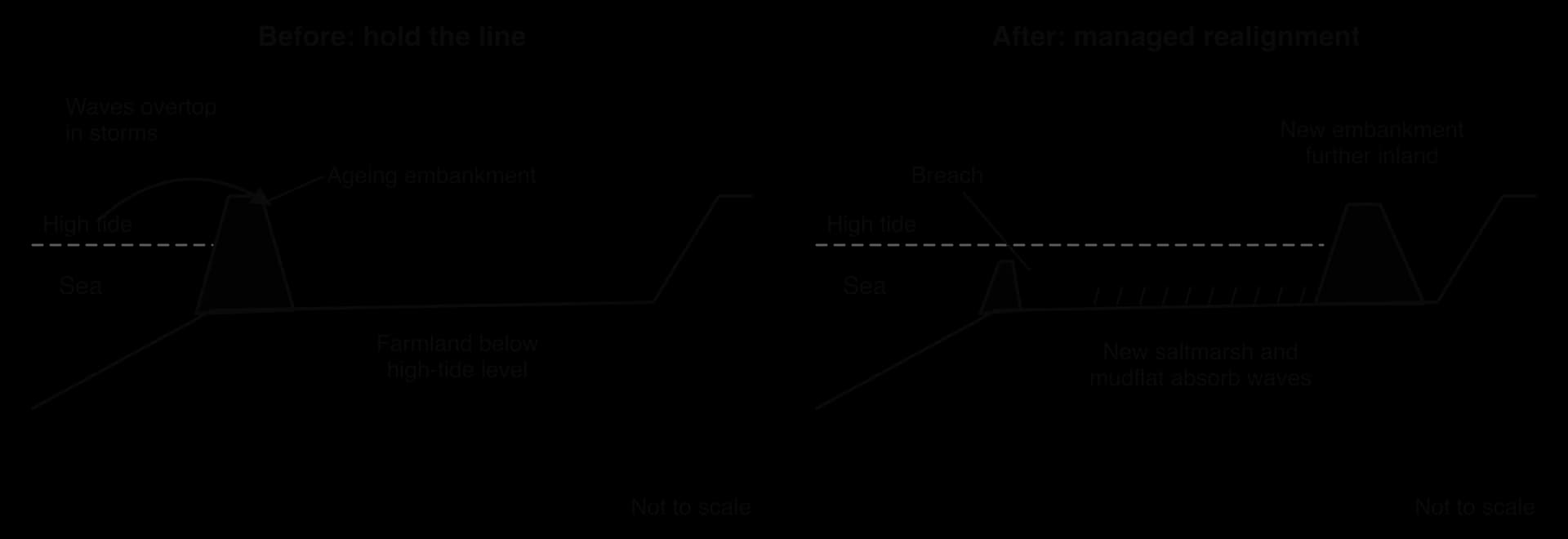
At Medmerry, near Selsey in West Sussex, a shingle bank and 1960s embankment were repeatedly breached, flooding farmland, caravan parks and roads. In 2013 the Environment Agency completed a new 7 km floodbank inland and let the sea through the shingle bank. The £28 million scheme was the largest open-coast managed realignment in Europe when built; the flooded land became an RSPB reserve, and homes behind it gained a higher standard of protection.
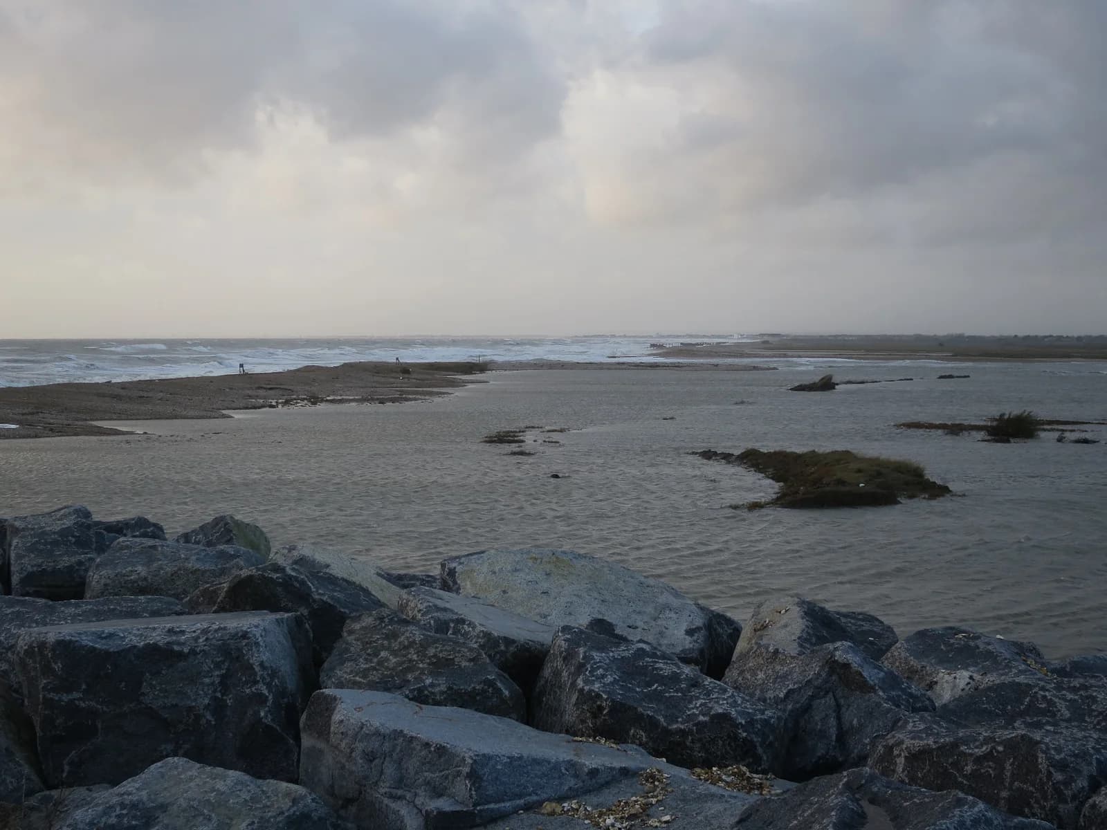
No active intervention means that no money is spent on building or maintaining defences, and the coast is left to erode or flood. It is chosen where land is of low value, where defences would cost more than the assets they protect, or where eroding cliffs supply sediment to the rest of the coast. It is cheapest for the state, but the costs fall on the people who own land on that stretch.
Happisburgh, on the soft cliffs of north-east Norfolk, shows what a change of policy means for residents. When its 1959 timber defences decayed, the cliff retreated by 50 m between 1996 and 1999. The 2012 shoreline management plan changed Happisburgh’s policy from holding the line to managed realignment, and 35 homes were lost between 1988 and 2025. In a pilot scheme from 2009 to 2011, the council bought nine properties at 40% of their market value and demolished them.
Choosing between defence, retreat and doing nothing is a political and economic decision as much as a technical one, because the people who pay are not always the people who benefit. Most countries now use formal planning frameworks that look at the whole coast over the long term.
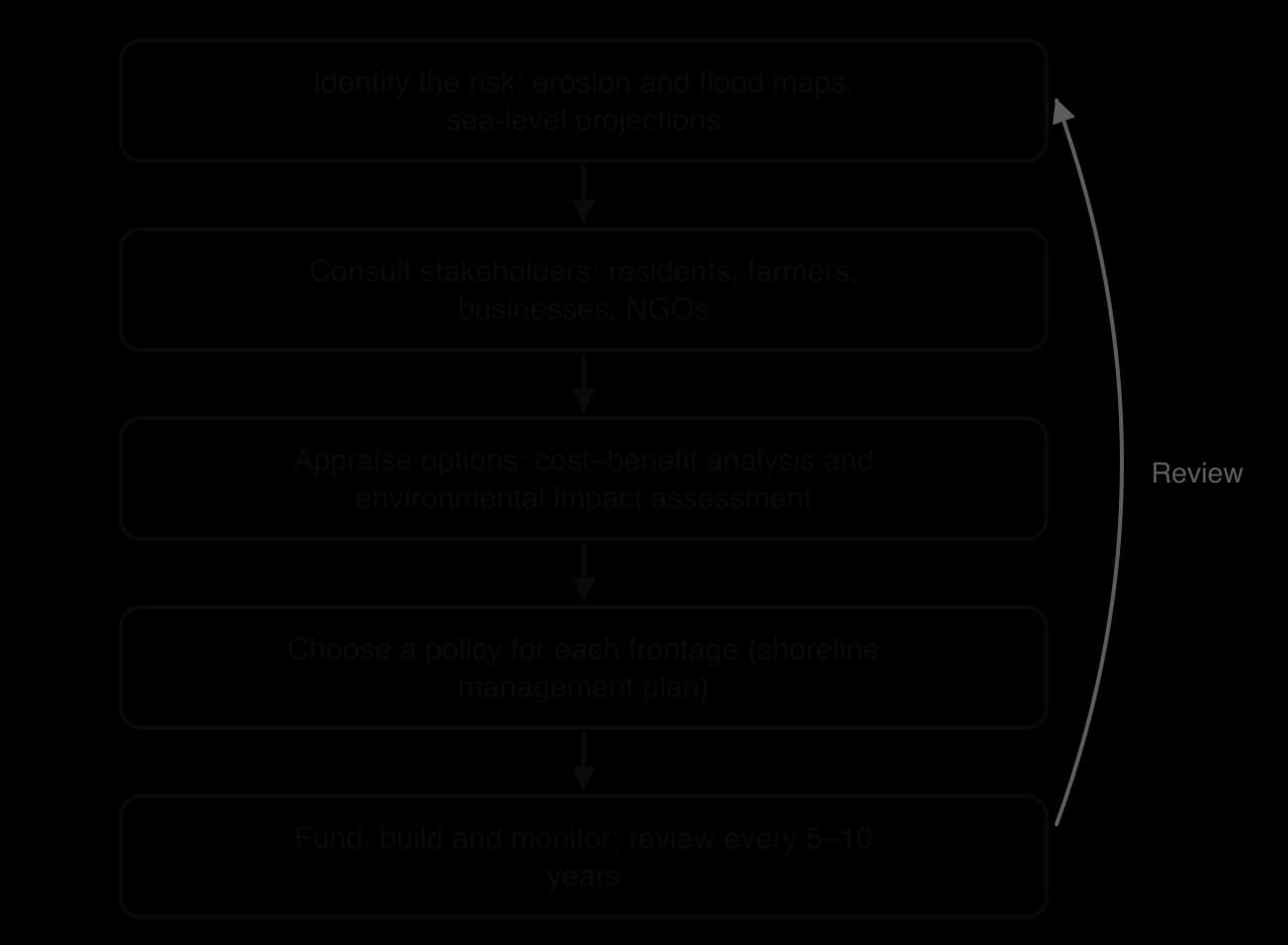
In England and Wales each sediment cell or sub-cell has a shoreline management plan (SMP) that sets a policy for every stretch of coast for three periods: up to 20 years, 20–50 years and 50–100 years. There are four policies: hold the line (keep the shoreline where it is with defences, used for towns and infrastructure), advance the line (build seaward, rare), managed realignment (as at Medmerry) and no active intervention (undeveloped coast).
SMPs make the sediment cell, rather than the council boundary, the unit of planning, and they make the long-term future visible to residents. Their weakness is that they are not legally binding or tied to guaranteed funding, so a policy of holding the line can still fail if no money is found.
A cost–benefit analysis compares the total cost of a scheme over its life with the value of the losses it prevents. A scheme is usually funded only if the benefits clearly exceed the costs.
Cost–benefit analysis makes decisions consistent and transparent, but it values things with a market price (houses, crops) more easily than heritage, a view or a sense of community, and it favours places where property is expensive. Two villages at equal risk can receive different decisions because their houses are worth different amounts, which raises questions of equity.
Large schemes also need an environmental impact assessment, a formal study of their likely effects on habitats, sediment movement and water quality before permission is given. Integrated coastal zone management (ICZM) goes further: it brings together government departments, councils, ports, fishers, tourism businesses, conservation groups and residents so that defence, development, fishing, tourism and conservation are planned together across land and sea. The European Union recommended it to member states in 2002. It treats the coast as one system and gives weaker groups a voice, but it has no power of its own to stop a powerful developer or ministry.
Stakeholder | Usual position | Power |
|---|---|---|
Homeowners and residents | Hold the line; full compensation if not | Votes and campaigns; little money |
Farmers | Defend farmland, or compensation | Own the land |
Local council | Defend the town centre; accept retreat elsewhere | Plans and permits; depends on national funds |
National agencies (e.g. the Environment Agency) | Whatever gives the best benefit–cost ratio nationally | Control most of the funding |
Conservation groups (e.g. the RSPB) | Managed realignment and soft engineering | Expertise, land ownership, public support |
Businesses (tourism, ports, energy) | Hold the line where their assets are | Money, jobs, political influence |
Insurers | Discourage building in risky places | Can withdraw cover, which lowers property values |
Criterion | Hard engineering | Soft engineering | Managed retreat / no active intervention |
|---|---|---|---|
Cost to build | High | Low to moderate, but repeated | Low for the state; high for those who lose land |
Standard of protection | High and predictable, until a design limit is exceeded | Moderate and less certain | Protection moves inland; some land is lost |
Effect on other places | Often harmful: toe scour, sediment starvation downdrift | Usually neutral or positive | Positive: restores sediment supply and habitat |
Response to sea-level rise | Must be raised again and again | Can grow with the sea if given space | Adapts by letting the coast move |
Who benefits most | Owners of high-value property behind the defence | Tourism, wildlife, the wider coast | Taxpayers and future generations |
Hard engineering remains the only realistic option where cities, ports and critical infrastructure sit at the shoreline, as in London, Rotterdam or Jakarta. Soft engineering is better value on most beach and dune coasts, where it protects without moving the problem elsewhere. Managed retreat is the most sustainable option in the long term on low-value land, but it is socially the hardest, because a few people bear losses so that the wider coast and the public purse benefit. As the sea rises, the length of coast that can be defended at reasonable cost will shrink, and more coasts are likely to move from holding the line towards realignment.
Coasts offer flat land, ports, fish, cooling water and the beaches that drive tourism, and many of the largest cities, from Shanghai to Lagos, grew as ports. The pressures on coastal land include:
Tourism and second homes: hotels, resorts and marinas cluster at the shoreline, often on dunes or cliff tops, raising land prices.
Ports and industry: container ports, refineries, gas terminals and nuclear power stations take large areas and alter sediment movement.
Housing and urbanisation: growing cities spread along the shore and onto wetlands; in many cities of low- and middle-income countries the poorest households live in informal settlements on the lowest, most flood-prone land.
Aquaculture: fish and shrimp ponds replace mangroves and saltmarsh on tropical coasts.
Conservation: national parks and marine reserves protect habitats and so restrict all the other uses.
Where flat land is scarce, it is made. Land reclamation creates new land from the sea or from wetlands by draining or filling them. Singapore grew by about 25%, from 581.5 km² in 1960 to 725.7 km² in 2019, mostly through reclamation for housing, the airport and industry. Dubai’s Palm Jumeirah, begun in 2001 for luxury homes and hotels, had over 25,000 residents by 2022.
A conflict matrix sets each land use against every other one to show which pairs can share a stretch of coast and which cannot, helping planners decide which uses must be separated.
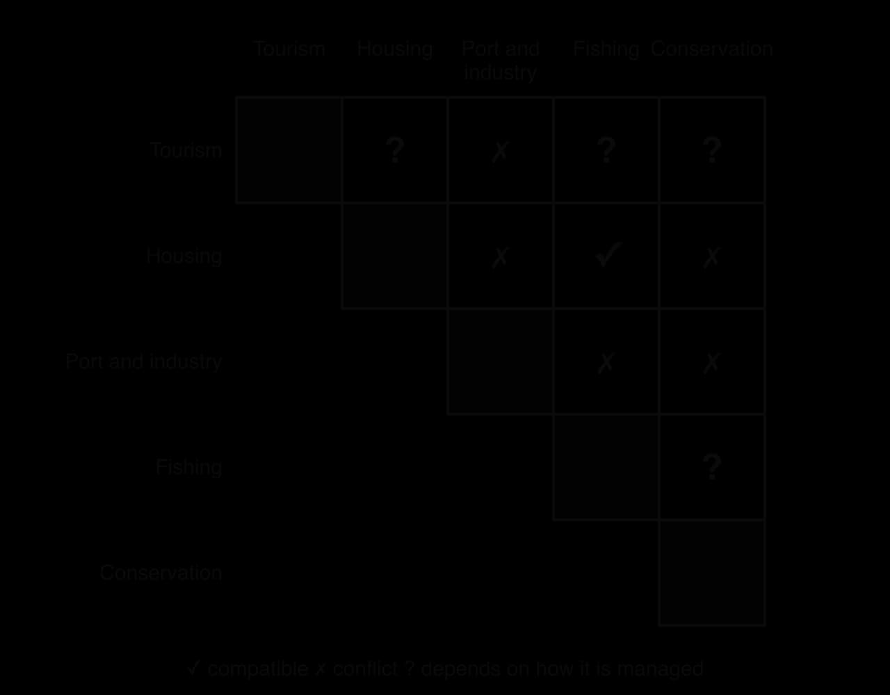
The matrix shows which uses clash, not who wins. Outcomes depend on power: capital to invest, backing from national government, legal ownership and the ability to be heard. Port authorities and developers usually have capital and political support; fishers, informal residents and wildlife usually do not. At Abbot Point in Queensland, a coal port expansion was approved in 2014 with a plan to dump about 3 million m³ of dredged seabed inside the Great Barrier Reef Marine Park; after protests by tourism operators, scientists and conservation groups, the spoil was moved to land and in 2015 the federal government banned dumping of such dredge spoil in the Marine Park.
Governments control coastal development with protected areas (national parks, marine reserves, Ramsar sites, World Heritage Sites), setback lines, coastal zoning and ICZM. A setback line keeps new building a fixed distance from the shore. Setback lines are cheap and avoid the need for defences later, but they are hard to apply where buildings already stand, and landowners resist them because they lower land values.
Spain’s Coastal Law (Ley de Costas) of 1988 made the shore public property and set a protection zone, normally 100 m inland, in which new building is restricted; a 2013 reform reduced it to 20 m in some areas that were already built up, after pressure from owners of homes built before 1988.
Coastal zoning gives each activity its own space: a port where dredging does least harm, tourism on resilient beaches, and dunes, marshes and reefs as conservation zones. The Great Barrier Reef Marine Park is the best-known example of zoning at sea.
The Gold Coast is a city of about 690,000 people (2025 estimate) along 70 km of sandy coast in south-east Queensland, Australia. About 10 million visitors a year come for its surfing beaches, theme parks and high-rise resorts such as Surfers Paradise, and tourism is its largest industry. In 1967 a series of eleven cyclones removed most of the sand from its beaches and exposed beachfront buildings built on the frontal dunes. The response, based on a 1971 report by engineers from Delft University, has shaped every stakeholder’s role since.
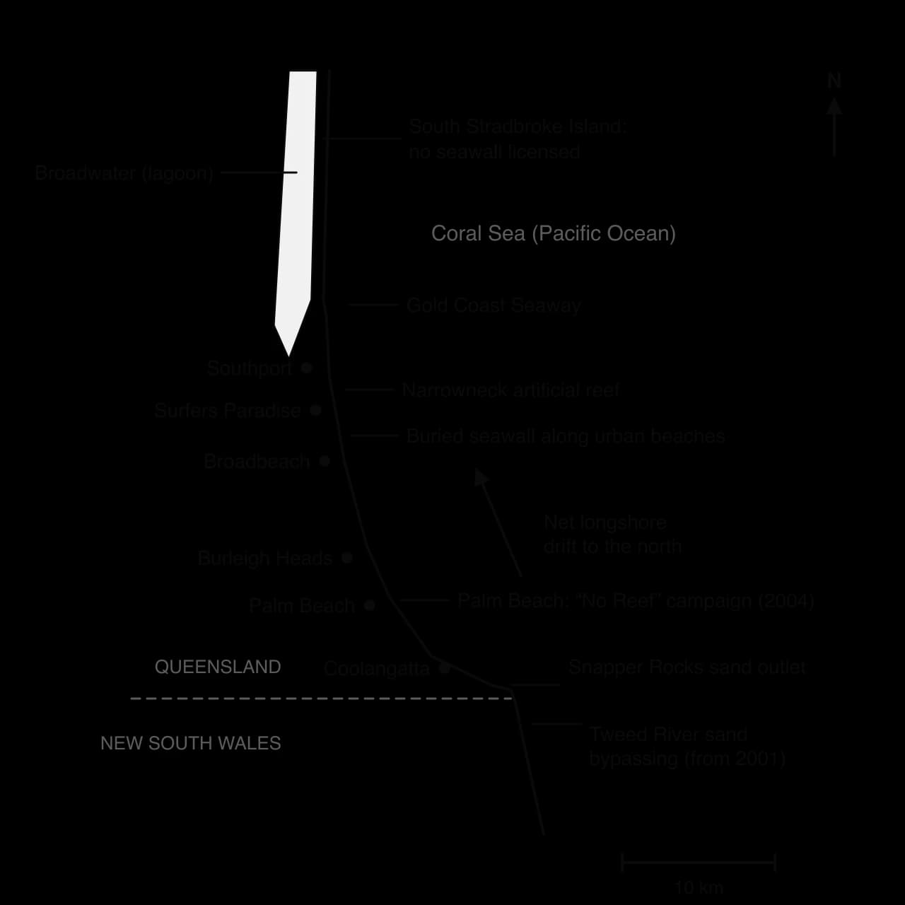
The map shows that the coast works as one sediment system. Sand moves north from the Tweed River towards the Seaway, so the bypassing scheme in the south supports the beaches of Coolangatta, Burleigh Heads and Surfers Paradise, and each stakeholder’s interest depends on what happens to the sand further south.
Stakeholder | Interests | Outcome |
|---|---|---|
Queensland Government and City of Gold Coast council | Protect the tourism economy and public land | A buried rock seawall in urban areas; a shoreline management plan from 2005 |
Beachfront owners and developers | Protect towers and homes worth millions of dollars | Must build the seawall in front of their land at their own expense (about A$3,000 per metre in 2006) before developing |
Tourism businesses | Wide, sandy beaches all year | Sand bypassing at the Tweed River (from 2001) pumps sand past the river mouth to keep beaches supplied |
Surfers | Good surf breaks | Lobbied to move the sand outlet at Snapper Rocks |
Palm Beach residents | Keep their beach natural | A “No Reef” campaign stopped a 2004 plan for three artificial reefs |
Conservation interests | Natural shoreline and wildlife | South Stradbroke Island and The Spit are not licensed for a seawall |
The groups with the most capital, the developers and the state, secured a defended, nourished shoreline that supports high property values, but they also carry most of the cost. Residents and surfers with little money still changed decisions through campaigns, and undeveloped land was left to natural processes.
Sources: Australian Bureau of Statistics (2025 estimate); City of Gold Coast shoreline management documents, as summarised in Wikipedia’s Gold Coast articles (accessed 2026).
A mangrove is a salt-tolerant tree or shrub of the intertidal zone on sheltered, muddy tropical and subtropical coasts, estuaries and deltas. Mangrove forests (mangrove swamps) covered about 137,600 km² in 118 countries and territories in 2010.
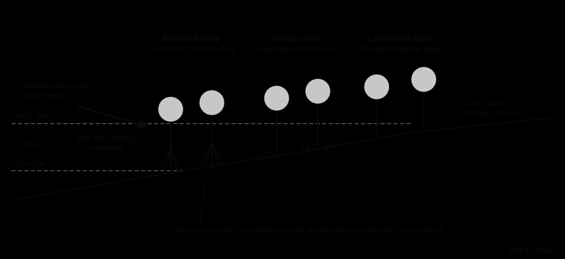
Mangroves provide many ecosystem services: dense roots reduce wave height and slow storm surges; sheltered channels are nurseries for fish, crabs and shrimp; communities take timber, fuelwood and honey; and waterlogged mangrove soils store large amounts of carbon, about 4.19 billion tonnes worldwide in 2012. Carbon held in coastal and marine ecosystems is called blue carbon, and it is released as carbon dioxide when mangroves are cleared.
Mangroves are cleared mainly for shrimp and fish ponds, rice fields, oil palm, resorts and urban growth. Losses were fastest in the late twentieth century: world mangrove area fell from about 188,000 km² in 1980 to 152,000 km² in 2005, about a fifth, with the largest losses in Asia, where shrimp ponds replaced mangroves in Indonesia, Thailand, Vietnam and the Philippines. Clearance has since slowed, and global mangrove area fell by a net 3,700 km² between 1999 and 2019, with annual losses of up to 0.7% in some countries.
Sources: FAO, The world’s mangroves 1980–2005 (2007); Global Mangrove Watch, as reported in Wikipedia’s Mangrove article (accessed 2026).
A coral reef is built from the calcium carbonate skeletons of coral polyps in warm, shallow, clear, nutrient-poor tropical water; the corals depend on zooxanthellae, algae in their tissues that supply food by photosynthesis. Reefs hold a large share of marine species, break waves and support fisheries and tourism. They face global threats, marine heatwaves that cause coral bleaching and ocean acidification that slows skeleton growth, together with local ones: overfishing and blast fishing, sediment and fertiliser runoff that feeds outbreaks of the coral-eating crown-of-thorns starfish, anchors and trampling, and coral mining.
Marine protected areas and no-take zones. A marine protected area (MPA) restricts human activities by law; a no-take zone inside it bans all fishing and collecting. Protected fish grow larger and spill over into fished areas nearby.
Community-based management. In Fiji, Locally Managed Marine Areas let villages set temporary closures (tabu areas), gear limits and seasons using customary authority.
Mangrove replanting. It restores protection and fisheries, but many projects fail because seedlings are planted on mudflats or in places flooded too often or too rarely, or with one fast-growing species.
Payment for ecosystem services. Under payment for ecosystem services, those who benefit from an ecosystem (a government, a tourism company, buyers of blue carbon credits) pay those who manage it to keep it intact.
Reef restoration. Reef restoration grows coral fragments in nurseries and transplants them, or fixes rubble so corals can settle. It helps small areas but is slow and costly.
Catchment management. Cutting the fertiliser, soil and sewage that reach the sea from land is as important as rules at sea.
Stakeholder | Value placed on reefs and mangroves | What they want |
|---|---|---|
Small-scale fishers | Food and income | Access; limits on industrial fleets |
Tourism operators | Diving and boat trips | Healthy reefs; moorings, not anchors |
Shrimp farmers and developers | Land for ponds and resorts | Permission to clear |
Conservation groups and scientists | Biodiversity, protection, carbon | Protected areas and monitoring |
National governments | Export and tourism income | Growth with enough protection |
Local and Indigenous communities | Food, fuel, cultural value | Rights to manage their own areas |
The Great Barrier Reef has over 2,900 reefs and 900 islands stretching more than 2,300 km along Queensland’s coast over about 344,400 km²; it became a World Heritage Site in 1981. Tourism, mainly diving, snorkelling and boat trips from Cairns, Port Douglas and the Whitsundays, is its largest commercial use.
Its average coral cover fell by about half between 1985 and 2012, mainly through tropical cyclones and outbreaks of crown-of-thorns starfish, and mass bleaching in 1998, 2002, 2016, 2017, 2020, 2022, 2024 and 2025 has since left little time for recovery. More than 90% of the pollution reaching it from rivers, its largest source of nutrients, comes from farms, mainly sugar cane and grazing.
The Great Barrier Reef Marine Park (1975) is managed by zoning; a 2004 plan raised the share in no-take zones from 4.5% to over 33%. The Reef 2050 Plan (2015, updated 2021) targets water quality, starfish control and restoration, and after UNESCO’s 2022 mission recommended an “in danger” listing, the government promised A$4.4 billion and an end to gill-net fishing by 2027.
Scientists argue that only deep cuts in greenhouse gas emissions can stop repeated bleaching; the coal and farming industries argue for development, and commercial fishers oppose the gill-net ban. Local management can improve water quality, but ocean temperature is decided at the global scale.
Sources: Great Barrier Reef Marine Park Authority; UNESCO World Heritage Centre (2022); Australian Government letter to UNESCO (May 2023), as reported in Wikipedia (accessed 2026).
The Sundarbans, the world’s largest mangrove forest, covers about 10,000 km² of the Ganges–Brahmaputra–Meghna delta, about 60% in Bangladesh and 40% in India, and each country’s part is a World Heritage Site. It is one of the last large habitats of the Bengal tiger and supports millions of villagers who collect fish, crabs, honey and wood. It is also a cyclone barrier: Cyclone Sidr damaged about 40% of the forest in 2007, but the forest absorbed much of the surge that would have reached villages inland.
Sea-level rise and reduced freshwater flow, partly linked to India’s Farakka Barrage upstream, are raising salinity, and shrimp farms press on its edges. The coal-fired Rampal power station, a project of Bangladesh’s Power Development Board and India’s NTPC agreed in 2010 and sited 14 km north of the forest, was criticised by UNESCO in 2016 and by groups citing the Ramsar Convention, while the Bangladeshi government argued that the country needed electricity. Because the forest, the river that feeds it and the threats to it cross the border, neither government can protect it alone.
Sources: UNESCO World Heritage Centre, as reported in Wikipedia’s Sundarbans article (accessed 2026).
Sovereignty is the supreme authority of a state over its territory. At sea, how far that control extends matters because the sea holds fish, oil, gas and minerals and carries trade and navies. The rules are set by the United Nations Convention on the Law of the Sea (UNCLOS), agreed in 1982 and in force since 1994, which has 172 parties, including 168 UN member states and the European Union. The United States has not ratified it, although it follows most of its navigation rules in practice.
All zones are measured from the baseline, normally the low-water line on official charts; along deeply indented coasts or fringing islands, straight baselines may join headlands or islands. Waters landward of the baseline (bays, estuaries, harbours) are internal waters under full state control.
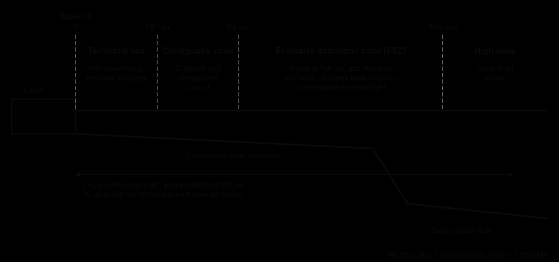
Zone | Extent from the baseline | Rights of the coastal state | Rights of other states |
|---|---|---|---|
Territorial sea | Up to 12 nautical miles (about 22 km) | Sovereignty over water, seabed and airspace | Innocent passage for ships |
Contiguous zone | 12 to 24 nautical miles | Enforce customs, tax, immigration and health laws | Freedom of navigation |
Exclusive economic zone (EEZ) | Up to 200 nautical miles (about 370 km) | Sole rights to fish, oil, gas, minerals, wind and wave energy | Freedom of navigation and overflight; cables and pipelines |
Continental shelf (legal) | Seabed to 200 nm, or to the edge of the continental margin up to 350 nm | Rights over seabed and subsoil resources | Use of the water above beyond 200 nm |
High seas | Beyond the EEZ | None | Open to all states |
A state does not own the water of its EEZ and cannot stop ships passing, but it alone decides who may fish, drill or mine there. Where the continental shelf runs beyond 200 nm, a state can claim seabed rights up to 350 nm by sending evidence to the UN Commission on the Limits of the Continental Shelf, which in 2008 confirmed Australia’s rights over an extra 2.5 million km². In the Arctic, Russia, Denmark (for Greenland) and Canada have made overlapping submissions for the seabed around the North Pole, including the Lomonosov Ridge, because retreating sea ice is making its resources easier to reach.
Every island generates its own territorial sea and EEZ. Kiribati has only 811 km² of land, but its 33 islands spread across about 3.4 million km² of the Pacific, earning income from licences sold to foreign tuna fleets. France, through its overseas territories, has an EEZ of about 10.2 million km², around 7% of the area of all EEZs.
UNCLOS distinguishes islands from rocks: a feature that cannot sustain human habitation or economic life of its own gets only a 12 nm territorial sea. Japan has encased the two rocks of Okinotori, with under 10 m² of dry land, in concrete and claims an EEZ around them; China, South Korea and Taiwan reject the claim. In 2016 an arbitral tribunal ruled that none of the Spratly Islands in the South China Sea can generate an EEZ. Where coasts are less than 400 nm apart, the EEZs overlap and the states must agree a boundary, usually a median line equidistant from the two baselines.
Jakarta, the capital of Indonesia, lies on the north-west coast of Java at the mouth of the Ciliwung River, facing Jakarta Bay and the Java Sea. The province covers about 664 km² and had about 11 million registered residents in 2025, while the United Nations estimated the population of the wider urban area at 41.9 million. It is built on a low alluvial plain that was once swamp, crossed by 13 rivers, and about 40% of it, mainly in the north, now lies below sea level.
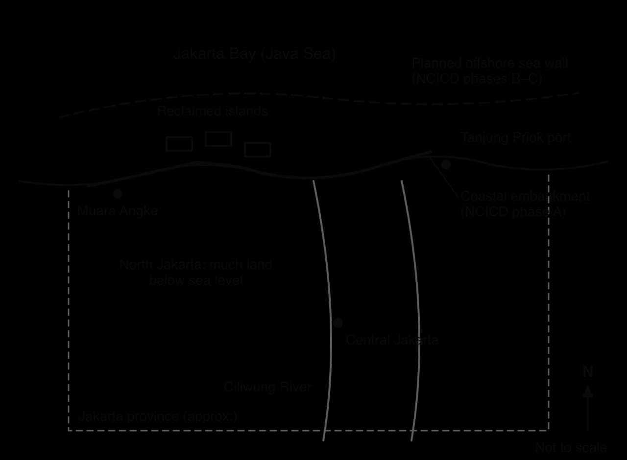
Jakarta’s coastal flood risk is driven mainly by the sinking of the land, and only partly by sea-level rise. The city is sinking through land subsidence, mainly because of the pumping of groundwater from the aquifers beneath the city: as water is removed, the fine clay and silt layers compact and the ground drops. The weight of buildings adds to the compaction. Households and businesses pump their own groundwater because the piped network has for decades been incomplete and expensive; in 2026 the city water company PAM Jaya still did not reach every household.
The National Research and Innovation Agency (BRIN) estimated in January 2026 that the city as a whole is sinking by about 3.5 cm a year, and that parts of North Jakarta have dropped by as much as 4 m in four decades. Other estimates for the north give 5–10 cm a year, ten to twenty times the rate of global sea-level rise.

As the ground sinks, seawater flows into low-lying districts at high tide (tidal or rob flooding), river water can no longer drain to the sea by gravity, and pumps must lift it over embankments. Monsoon rain, blocked drains and urban growth upstream add river floods. In 2007 about 70% of the city was flooded, up to 4 m deep in places, and about 80 people died. BRIN estimates that floods cost Jakarta at least US$186 million a year, rising to US$421 million by 2030 if subsidence continues.
 YouTube
Three responses have been debated, each favoured by different actors with very different amounts of power.
1. Walls and reclamation: the National Capital Integrated Coastal Development (NCICD). A master plan drawn up by the Indonesian government with Dutch firms. Phase A strengthens and raises the existing coastal embankments; later phases would build a giant offshore sea wall across Jakarta Bay enclosing a lagoon to store river water, with 17 artificial islands for offices, housing, a port and toll roads. The full plan was estimated at about US$40 billion.
Construction began on 9 October 2014; by January 2026 only about 20 km of the 46 km NCICD embankment had been built.
2. Stopping the cause: controlling groundwater. In 2021 the governor banned groundwater extraction in nine industrial areas and along 12 roads, and the city is extending piped water. Scientists at BRIN and the National University of Singapore argue that without stopping groundwater pumping, any wall will only buy time, because the land behind it will keep sinking.
3. Moving the seat of government: Nusantara. In August 2019 President Joko Widodo announced that the capital would move to a new city in East Kalimantan, on the island of Borneo. Nusantara is planned in five phases to 2045 at an estimated Rp 523 trillion (about US$35 billion). Indonesia held its Independence Day there for the first time on 17 August 2024. Jakarta remains the capital until a presidential decree formally transfers the role.
Actor | Interests and position | Power and outcome |
|---|---|---|
National government (presidents, Bappenas, Ministry of Public Works) | Protect the economic heart of the country; build a new capital as a symbol of development outside Java | Controls funding and law; chose both the NCICD and Nusantara; President Prabowo Subianto has proposed a giant sea wall along Java’s north coast, from Banten to East Java, to take 15–20 years |
Jakarta provincial government | Protect the city; issue reclamation permits | Builds part of the embankment; permits challenged in court |
Property developers (e.g. Agung Podomoro and Agung Sedayu groups) | Profit from new land on reclaimed islands | Won permits and a Supreme Court ruling in 2011; work was halted in 2016 after a bribery arrest linked to coastal zoning rules, then resumed in 2017 |
Ministry of Environment and Ministry of Marine Affairs and Fisheries | Protect water quality, marine life and fishers’ incomes | Ruled in 2003 that reclamation was not feasible because it would raise flood risk and harm fishers; overturned in court |
Fishers and NGOs (WALHI, KIARA) | Fishing grounds; no polluted lagoon | An appeal to stop work on one island was rejected |
Kampung (informal settlement) residents | Homes and livelihoods close to the sea | Some settlements were cleared and residents evicted when the sea wall was extended; little voice in decisions |
Scientists (BRIN, universities) | Tackle groundwater use | Evidence led to the groundwater ban; enforcement is partial |
The outcomes have been uneven. The embankments that have been built have reduced tidal flooding compared with unprotected coasts elsewhere in Java, such as Demak. But the poorest residents, nearest the sea and most reliant on groundwater, face the highest risk, while reclaimed land would mainly benefit investors. Critics argue that the public pays for the walls while developers take the profits.
Key concept | How Jakarta shows it |
|---|---|
Place | A delta city on soft sediments, with fast population growth and an incomplete water network, is far more exposed than a city on rock with the same rise in sea level. |
Process | Groundwater extraction compacts clay layers, causing subsidence that dominates the relative rise in sea level; walls address the symptom, not the process. |
Power | National government, developers and foreign engineers shaped the plan; fishers and kampung residents were consulted least and bore the most cost. |
Possibility | The options range from higher walls, through controlling groundwater, to moving the seat of government; none removes the risk to the 11 million people who will stay. |
Jakarta shows that coastal decisions are rarely about the coast alone. The most effective long-term measure, replacing groundwater with piped water, is a question of urban water supply and equity, while the most visible measures, walls and a new capital, attract investment and attention. Nusantara is planned to house government ministries, while Jakarta’s residents and its main port, Tanjung Priok, will still depend on defences that must be raised as the land sinks.
To what extent is the Jakarta sea wall a sustainable solution to the city’s flood risk?
Which stakeholders gain most from the NCICD plan, and which lose most? Explain why.
Suggest why controlling groundwater use has proved harder to achieve than building embankments.
Sources: BRIN, reported by Asia News Network (2026); Indonesia Water Portal (2023); Statistics Indonesia and UN DESA, as reported in Wikipedia’s Jakarta article (2025); Wikipedia: Floods in Jakarta, Giant Sea Wall Jakarta and Nusantara (accessed 2026).
The map and table show part of a hypothetical shoreline management plan for a 30 km stretch of eroding coast. Study them and answer the questions.
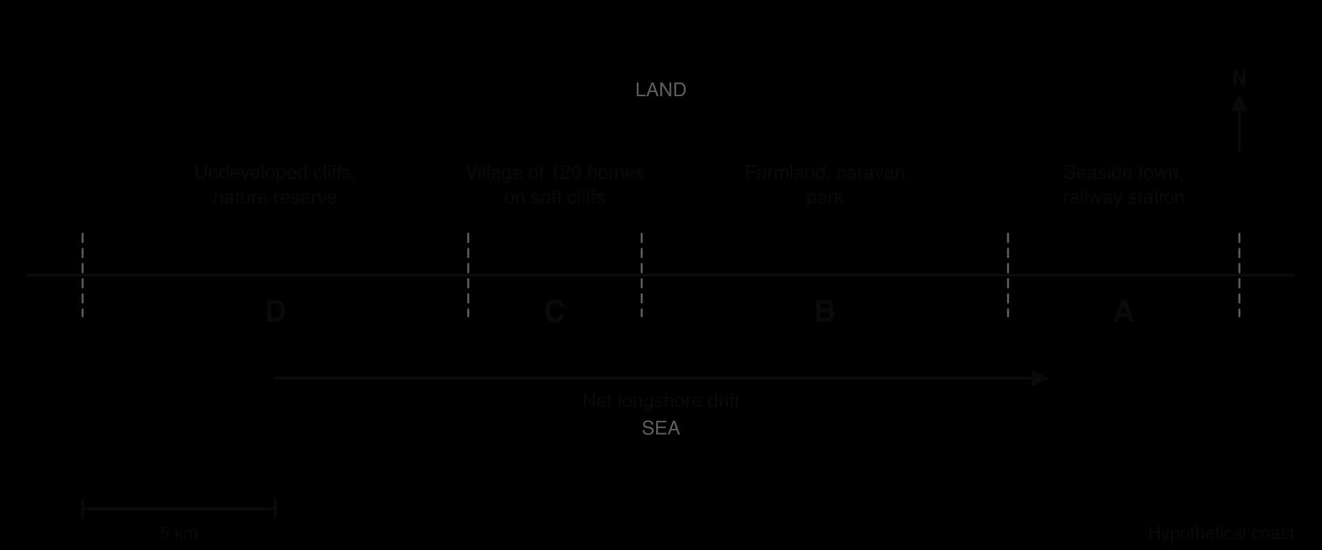
Policy unit | Length (km) | Land use behind the shore | Policy, 0–20 years | Policy, 20–50 years |
|---|---|---|---|---|
A | 6.0 | Seaside town, promenade, railway station | Hold the line | Hold the line |
B | 9.5 | Farmland, two farmhouses, caravan park | Hold the line | Managed realignment |
C | 4.5 | Village of 120 homes on soft cliffs | Hold the line | Managed realignment |
D | 10.0 | Undeveloped cliffs, nature reserve | No active intervention | No active intervention |
Defences in one place can increase erosion elsewhere in the same sediment cell.
Hard engineering gives strong protection at high cost, with side effects such as toe scour and sediment starvation downdrift.
Soft engineering works with natural processes but must be repeated or maintained.
Cliff stabilisation secures cliff tops but can cut off sediment supply to other beaches.
Managed retreat and no active intervention are cheaper and more sustainable in the long term but transfer losses to landowners.
Shoreline management plans, cost–benefit analysis and ICZM structure decisions; power, money and compensation decide who gains and who loses.
Conflict matrices, protected areas, setback lines and zoning help manage competing coastal land uses, as on the Gold Coast.
Reefs and mangroves are managed through protected areas, no-take zones, community management, replanting, restoration and payments for ecosystem services.
UNCLOS gives sovereignty to 12 nm, limited control to 24 nm and resource rights to 200 nm; islands, rocks and sea-level rise make zones contested.
In Jakarta, groundwater-driven subsidence drives flood risk; walls, groundwater controls and a new capital reflect very differently placed actors.
I can describe how sea walls, revetments, rock armour, gabions, groynes, offshore breakwaters and storm surge barriers work, with costs and side effects.
I can explain how beach nourishment, dune regeneration, cliff stabilisation and managed retreat work, with named examples.
I can examine how shoreline management plans, cost–benefit analysis and ICZM are used to make coastal decisions.
I can determine a benefit–cost ratio and use it to compare two coastal management options.
I can evaluate hard and soft approaches from the perspectives of different stakeholders.
I can explain coastal land-use conflicts using a conflict matrix and the Gold Coast example.
I can discuss the value, threats and management of coral reefs and mangroves, using the Great Barrier Reef and the Sundarbans.
I can outline the UNCLOS maritime zones and convert nautical miles to kilometres.
I can evaluate the outcomes of coastal management in Jakarta for different groups of people.
Intergenerational inequity: present consumers benefit from fossil fuels, while costs of climate change and long-lasting seabed damage fall on future generations and low-lying states.
Good answers may be well structured (AO4) and may additionally offer a critical evaluation (AO3) which examines how the distribution of costs and benefits depends on governance, eg Norway's state ownership and sovereign wealth fund spread oil benefits widely, unlike states with weak institutions (places, power). Another approach might be to consider different scales: a national gain may hide local losses (scale), or to discuss how international law (UNCLOS, ISA rules, the polluter-pays principle) attempts to share benefits and costs more fairly (possibilities, equity).
For 5–6 marks, expect some weakly-evidenced outlining of costs and/or benefits of abiotic resource use for one or more groups.
For 7–8 marks, expect a structured account which includes:
either well-evidenced explanation of how costs and benefits are distributed between different places and/or people
or a discursive conclusion (or on-going evaluation) of the extent of inequality grounded in geographical concepts and/or perspectives.
For 9–10 marks, expect both of these traits.
NB. Maximum [4] if the answer only discusses biotic resources.
Marks | Level descriptor |
|---|---|
0 | The response does not reach a standard described by the descriptors below. |
1–2 | Too brief, lists unconnected information, not focused on the question and lacks structure. Knowledge is very general, with large gaps or errors; examples or case studies are missing or only listed. No analysis; terminology is missing or used incorrectly. |
3–4 | Too general, lacks detail, not focused on the question and largely unstructured. Outlines examples, statistics and facts, both relevant and irrelevant, with links to the question only listed. Basic terminology is used, with errors or inconsistently. No critical evaluation of evidence; any conclusion is irrelevant. |
5–6 | Partially addresses the question, with a narrow argument, an unsubstantiated conclusion and limited evaluation. Describes relevant supporting evidence (examples, case studies) and outlines links to the question. The argument repeats one point or covers only part of the question. Other perspectives, or strengths and weaknesses of evidence, are listed. |
7–8 | Addresses the whole question; the analysis is evaluated and the conclusion is relevant but lacks balance. Relevant evidence is described correctly and covers all the main points. The argument is clear but one-sided or unbalanced. Complex terminology is used correctly but not consistently. Other perspectives, or strengths and weaknesses of evidence, are described. |
9–10 | In-depth and specific to the question (topic and command term). Correct, relevant examples, statistics and detail are integrated and their link to the question explained. The argument is balanced, explaining complexity, exceptions and comparisons. Evaluation of evidence and perspectives is well developed, and the conclusion is balanced and aligned with the evidence. Logically structured and easy to follow. |
To what extent can aquaculture meet the growing global demand for fish without creating new environmental problems?
10 marks
Examine the strengths and weaknesses of marine protected areas as a strategy for managing fish stocks.
10 marks