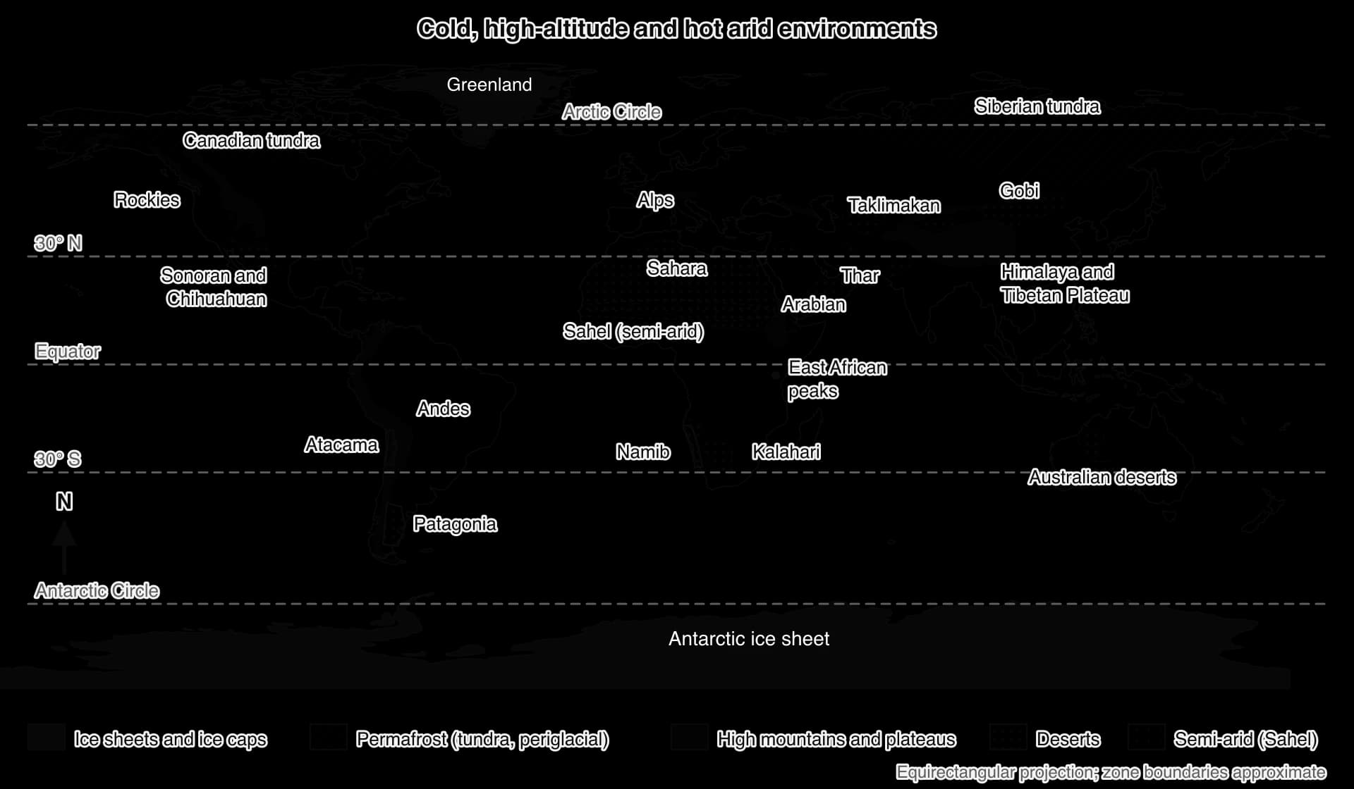
Describe where cold, high-altitude and hot arid environments are and explain why, analyse the climate and relief that make them extreme, examine the challenges they pose for people, and explain how their extent changes over time.
Each is in the Geography glossary, with every other term in the subject.
A period from about 14,500 to about 5,000 years ago, often called the Green Sahara, when stronger monsoon rains turned much of the Sahara into grassland and savanna with lakes and rivers.
An illness caused by the low oxygen pressure at high altitude, with headache, nausea, fatigue and breathlessness, usually affecting people who climb quickly above about 2,500 m.
An environment in which potential evaporation greatly exceeds precipitation, giving a water deficit for most or all of the year; its aridity index lies between 0.05 and 0.2.
A permanent shortage of moisture in a climate, caused by low precipitation relative to potential evaporation; a long-term characteristic of a place, unlike drought, which is temporary.
A measure of dryness equal to mean annual precipitation divided by mean annual potential evapotranspiration; below 0.05 is hyper-arid, 0.05–0.2 arid, 0.2–0.5 semi-arid and 0.5–0.65 dry sub-humid.
A measure of relative variability equal to the standard deviation of a set of values divided by their mean, multiplied by 100; for annual rainfall, a higher percentage means less reliable rain.
The effect of distance from the sea on climate: places deep inside a large continent have a larger annual temperature range and usually less precipitation than coastal places at the same latitude.
Describe the global distribution of cold, high-altitude and hot arid environments, using latitude, continents and named examples.
Explain why hot deserts lie near 30° N and S, in continental interiors, in rain shadows and beside cold ocean currents.
Distinguish between arid and semi-arid environments using the aridity index.
Explain the relief and climatic characteristics that make cold, high-altitude and hot arid environments extreme.
Explain why dryland rainfall is unreliable and intense, and how flash floods develop.
Construct and interpret climate graphs, and determine temperature ranges and the coefficient of variation of rainfall.
Examine how relief, climate, human discomfort, inaccessibility and remoteness challenge habitation and resource development.
Explain how the distribution of extreme environments changes over time, including glacier advance and retreat and natural desertification.
An extreme environment is a place where climate and relief set severe limits on plant growth, human comfort and economic activity. Two kinds are distinguished: cold and high-altitude environments (polar regions, glacial and periglacial areas and high mountains) and hot arid environments (hot deserts and semi-arid areas). Both cover large areas of the Earth but hold only a small share of its people.
The topic is above all about place: why some places are extreme, how they differ and how their characteristics shape the lives of the people who live there. It also introduces the atmospheric and ice-age processes that create extreme environments and move their boundaries over time.
76 exam-style questions on this subtopic, written in the style of the IB papers. The first has its markscheme open. Counted on
Examine the reasons why periglacial landscape features vary from place to place.
10 marks
Marks should be allocated according to the markbands.
Periglacial environments are cold, non-glacial environments where freezing and thawing of ground and frost processes dominate. They occur at high latitudes (eg Siberia, northern Canada, Alaska, Svalbard) and at high altitudes in lower latitudes (eg the Tibetan Plateau, Andes, Alps). Features include permafrost, the active layer, patterned ground, ice wedges, pingos, solifluction lobes and terraces, blockfields and scree, nivation hollows and thermokarst. Their occurrence and form vary with climate, permafrost type, slope, sediment, water supply, vegetation and time.
Possible applied themes (AO2) demonstrating knowledge and understanding (AO1):
Climate: very cold continental interiors (eg Siberia, where permafrost reaches depths of up to about 1500 m) support continuous permafrost and ice wedges; milder areas have discontinuous or sporadic permafrost, where open-system pingos and palsas are more typical.
Number of freeze-thaw cycles: mountain areas with daily cycles have more frost shattering, blockfields and scree than high-latitude lowlands that remain frozen for months.
Slope: patterned ground forms circles and polygons on flat ground but elongates into stripes on slopes; solifluction lobes and terraces need slopes as gentle as 2°, with saturated active layers.
Sediment and water: frost heave and ice segregation require fine-grained, moisture-retaining sediments (silts); closed-system pingos need drained lake beds (eg Tuktoyaktuk Peninsula, about 1350 pingos), and open-system pingos need groundwater under pressure.
Snow and vegetation cover insulate the ground, reducing the depth of freezing; peat and moss affect active-layer thickness and the spread of thermokarst.
With a free account, Augment remembers where you stopped and what you have practiced.
The difference between the highest and lowest temperatures at a place within 24 hours, or between the mean daily maximum and mean daily minimum for a month.
Areas with an aridity index below 0.65, made up of hyper-arid, arid, semi-arid and dry sub-humid lands, in which water is the main limit on plant growth and human activity.
An environment in which climate and relief set severe limits on plant growth, human comfort and economic activity, so that it supports few people without special adaptation; cold, high-altitude and hot arid environments are the main types.
A long cold phase within an ice age, lasting tens of thousands of years, during which global temperatures fall, ice sheets and glaciers advance over large areas and sea level falls.
A large mass of ice, formed on land from compacted and recrystallised snow, that moves slowly downslope or outwards under its own weight.
A large atmospheric circulation in which air rises near the Equator, flows poleward at 12–15 km, sinks near 30° latitude, creating subtropical high pressure, and returns towards the Equator as the trade winds.
The strain on the body when it cannot lose enough heat to keep its core temperature stable, caused by high temperature, humidity, sunshine and exertion; it ranges from heat exhaustion to heat stroke.
A mountain or plateau environment outside the polar regions where low temperature, low air pressure, intense solar radiation and steep relief make conditions extreme because of height above sea level.
An arid environment with very low annual precipitation, usually under 250 mm, high daytime temperatures for most of the year and sparse vegetation, such as the Sahara or the Kalahari.
A dangerous fall in the body's core temperature below 35 °C, caused by losing heat faster than it is produced, especially in cold, wet or windy conditions.
A dome-shaped mass of glacier ice covering less than 50,000 km², usually over an upland or plateau, from which ice flows outwards in all directions.
A mass of glacier ice covering more than 50,000 km² of land, burying almost the whole land surface; the two present-day ice sheets cover Antarctica and Greenland.
The physical difficulty of reaching a place because of barriers such as mountains, ice, sea ice, sand seas or a lack of roads, ports and airstrips, which may vary with the season.
The understanding, skills and practices developed by a local or indigenous community over many generations through close interaction with its environment, and passed on through culture and practice.
The descendants of the people who lived in a region before later settlers or states arrived, who keep distinct languages, cultures and ties to their land, such as the Inuit, Sámi or Tuareg.
A warmer phase between glacial periods, lasting thousands to tens of thousands of years, when ice sheets retreat to roughly their present extent; the present interglacial is the Holocene.
A wind of cold, dense air that flows downslope under gravity from an ice sheet, plateau or mountain, often reaching very high speeds where it is channelled into coastal valleys.
The rate at which air temperature falls with increasing height in the lower atmosphere; the environmental lapse rate averages about 6.5 °C per 1,000 m but varies with time and place.
The time, between about 26,000 and 20,000 years ago, when the ice sheets of the most recent glacial period reached their greatest extent and sea level was about 125 m lower than today.
A cool period from about 1300 (or the 16th century) to about 1850, during which glaciers in the Alps and elsewhere advanced to their largest extent of recent millennia.
A cold, non-glacial environment near ice sheets or glaciers or at high altitude, in which the ground is frozen for much or all of the year and repeated freezing and thawing shapes the land.
An environment in the high latitudes, mostly within the Arctic and Antarctic Circles, where the warmest month averages below about 10 °C, winters are long and dark, and precipitation is usually low.
The most recent geological period, from about 2.58 million years ago to the present, characterised by repeated cycles of glacial and interglacial periods.
The reduction of precipitation on the leeward side of a mountain range, because moist air loses its water as it rises over the windward side and then descends, warms and dries.
The degree to which annual rainfall at a place differs from its long-term average from year to year; high variability means low reliability and is usually greatest where rainfall is lowest.
The distance, in space, time or cost, between a place and the main centres of population, markets, services and political power, which raises transport and labour costs and isolates residents.
A dry environment, usually on desert margins, with an aridity index of 0.2–0.5 and typically 250–500 mm of rain in a short wet season, supporting grassland, scrub and rain-fed farming in good years.
A treeless biome of high latitudes and high mountains in which low temperatures and a short growing season limit vegetation to mosses, lichens, grasses and dwarf shrubs, usually over permafrost.
The cooling effect of wind on exposed skin, expressed as the lower air temperature that would cause the same rate of heat loss in calm conditions.
Scope: The syllabus covers the global distribution of cold, high-altitude and hot arid environments; the relief and climate that make them extreme, including unreliable and intense rainfall and flash floods in arid areas; how relief, climate, human discomfort, inaccessibility and remoteness challenge habitation and resource development, with detailed examples; and how the distribution of extreme environments changes through glacier advance and retreat and natural desertification. Extreme environments is one of seven options, from which SL students study two and HL students three.
An environment is called extreme when one or more physical conditions lie close to, or beyond, the limits that plants, animals and people can tolerate without special adaptation. The limiting condition is usually climatic: very low or very high temperatures, too little water, too little oxygen or too little light.
They share low biological productivity, very low population density and nodal settlements clustered around a single resource such as an oasis, a mine or a port.
Kind | Types | Main limiting conditions | Named examples |
|---|---|---|---|
Cold and high-altitude | Polar; glacial (ice sheets, ice caps, glaciers); periglacial (tundra); high mountains outside the poles | Very low temperatures, polar night, frozen ground, low oxygen, steep relief | Antarctica, Greenland, Svalbard, Siberia, the Himalaya and Tibetan Plateau, the Andes, the Alps |
Hot arid | Hot deserts (hyper-arid and arid); semi-arid areas | Low and unreliable rainfall, heat, high evaporation, dust | Sahara, Arabian, Thar, Kalahari, Namib, Atacama, Australian deserts, the Sahel |
Cold environments are found at high latitudes and high altitudes. The four types overlap: much of Greenland is both polar and glacial, and the Tibetan Plateau both high-altitude and periglacial.
Polar environments lie mostly within the Arctic and Antarctic Circles (66.5° N and S). In the north they include the Arctic Ocean with its sea ice, Greenland, northern Canada, Svalbard and the northern coasts of Russia, Alaska and Scandinavia. Antarctica covers more than 14.2 million km² and is the coldest, driest and windiest continent; it receives over 200 mm of precipitation a year on its coasts and far less inland.
Glaciers cover about 10% of the Earth’s land surface today, almost all of it in two ice sheets: the Antarctic ice sheet (about 14 million km²) and the Greenland ice sheet (about 1.7 million km²).
Smaller masses that bury uplands are ice caps, found in Iceland, Svalbard and the Canadian Arctic islands.
Ice sheets, ice caps and the valley glaciers of the Alps, the Himalaya, the Andes and Alaska are all glaciers.
Periglacial environments are cold areas near, but not covered by, ice. Their defining feature is permafrost, ground that stays at or below 0 °C for at least two years in a row. About 15% of the exposed land of the northern hemisphere is directly underlain by permafrost, and 22% lies within the permafrost zone.
Much periglacial land is covered by tundra, a broad belt across northern Canada, Alaska and Siberia north of the tree line, where summers are too short and cool for trees.
High-altitude environments are extreme because of height rather than latitude: the Himalaya and the Tibetan Plateau (much of it above 4,000 m), the Andes, the Rocky Mountains, the Alps and the volcanic peaks of East Africa. Kilimanjaro, 5,895 m high and 3° south of the Equator, carries ice above savanna.
The height at which conditions become extreme falls with latitude: near the Equator people farm in the Andes at 3,500–4,000 m, while in the polar regions extreme conditions begin at sea level.
Hot arid environments are defined by a shortage of water. A hot desert has very low rainfall and high temperatures for most of the year; semi-arid environments surround the deserts and receive enough rain for grassland, scrub and some rain-fed farming, but the rain is short-lived and varies greatly from year to year.
The largest hot deserts are the Sahara, the Arabian Desert, the Thar, the Kalahari and Namib, the deserts of central and western Australia, the Atacama, and the Sonoran, Mojave and Chihuahuan deserts of the south-western USA and northern Mexico. Their hyper-arid cores may go years without rain, while the arid zone around them receives a little most years.
The best-known semi-arid region is the Sahel, a belt several hundred to a thousand kilometres wide that stretches 5,900 km from the Atlantic to the Red Sea along the southern edge of the Sahara. Its annual rainfall rises from about 100–200 mm in the north to 700–1,000 mm in the south.
Aridity cannot be measured by rainfall alone: 300 mm a year keeps grassland alive in a cool climate but supports only scrub in a hot one, because heat drives far more evaporation. The aridity index used by the United Nations Environment Programme therefore divides mean annual precipitation by mean annual potential evapotranspiration (PET), the water that would be lost if it were always available.
Class | Aridity index (P ÷ PET) | Share of global land | Typical vegetation |
|---|---|---|---|
Hyper-arid | Below 0.05 | 7.5% | Almost none: rock, gravel and sand seas |
Arid | 0.05–0.20 | 12.1% | Scattered drought-tolerant shrubs and grasses |
Semi-arid | 0.20–0.50 | 17.7% | Grassland, thorn scrub, open savanna |
Dry sub-humid | 0.50–0.65 | 9.9% | Grassland and dry woodland |
Together these classes form the drylands, which cover 41.3% of the Earth’s land, including 66% of Africa, and are home to more than 2 billion people.
Sources: UNEP, World Atlas of Desertification, 1992 (aridity classes); UNCCD drylands figures via Wikipedia, accessed 2026.
Aridity is usually mapped as a choropleth, with each aridity class shaded more darkly as the index falls. On a world map the classes form rough rings: hyper-arid cores such as the central Sahara, the Rub’ al Khali, the Taklimakan and the Atacama are surrounded by arid land, then by semi-arid and dry sub-humid belts that merge into humid climates. The Sahel shows this gradient clearly, with the index rising southwards from the Sahara towards the savannas of West Africa.
A choropleth has limits. Each class covers a range of values, so a sharp line on the map may separate places with almost the same index, while large differences inside one class are hidden. The index is also built from long-term averages of rainfall and estimated evapotranspiration, so it shows the typical climate of a place, not the droughts and wet years that matter to farmers.
Four factors explain why most hot deserts lie near 30° N and S, on western coasts and in continental interiors; in many deserts two or more act together.
Near the Equator the Sun heats the ground strongly. Warm, moist air rises in cumulonimbus clouds, cools, and its water vapour condenses, giving heavy rain to the rainforests in the belt of low pressure called the Intertropical Convergence Zone (ITCZ). This rising air is one branch of the Hadley cells.
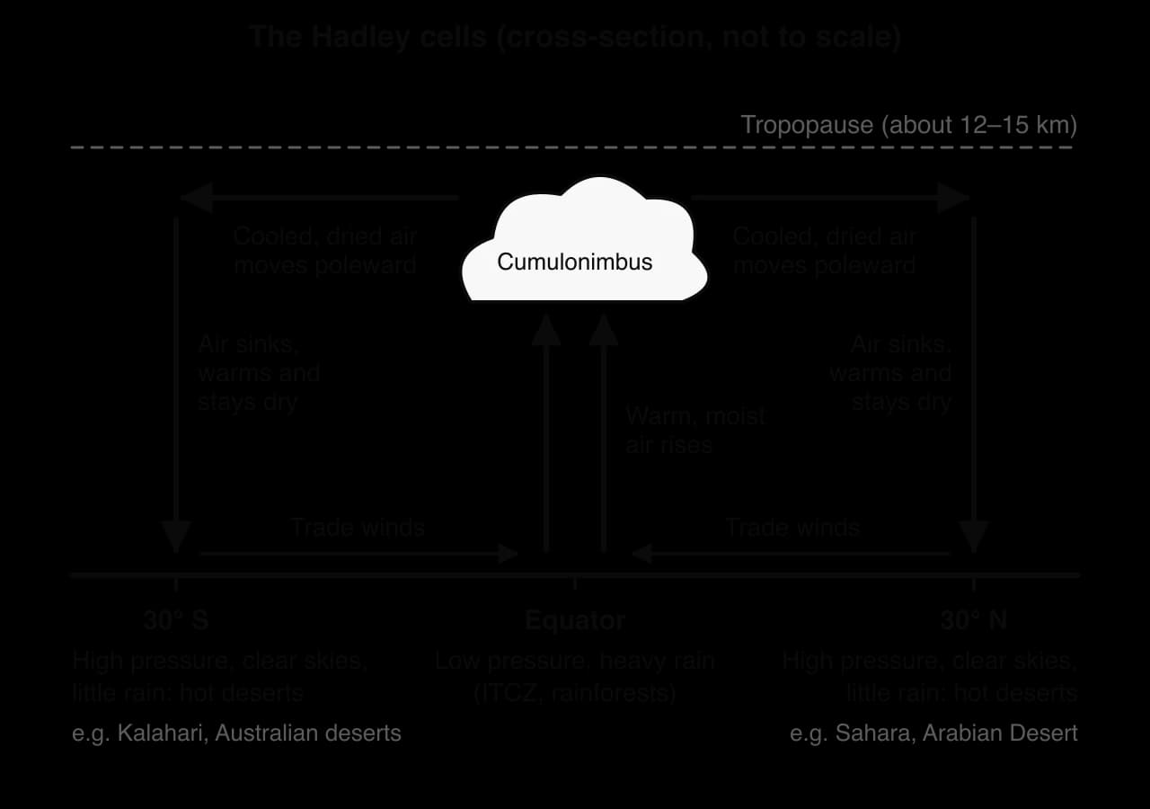
High in the atmosphere the dried air flows poleward and sinks near 30° N and S. Sinking air is compressed and warms, its relative humidity falls and clouds cannot form, so the subtropics have high pressure, clear skies and very little rain. The Sahara, Arabian, Kalahari and Australian deserts lie beneath it, and the trade winds that blow back towards the Equator cross land and bring little moisture.
 YouTube
Most atmospheric moisture evaporates from the oceans, so air that travels far over land has lost much of it. Places deep in a continent are therefore dry as well as having hot summers and cold winters, an effect of continentality. The Gobi and Taklimakan, at 36–46° N, are cold-winter deserts: the Gobi ranges from −40 °C in winter to 45 °C in summer.
Moist air forced over a mountain range cools and drops rain or snow on the windward slopes, then descends the far side, warming and drying. The lee side lies in a rain shadow. The Patagonian Desert of Argentina, the largest desert south of 40° S, formed as the Andes rose and blocked moist westerly winds from the Pacific.
Some of the driest deserts lie on west coasts beside cold currents fed by upwelling: the Atacama beside the Humboldt Current and the Namib beside the Benguela Current. Cold water chills the air above it, leaving cool air beneath warmer air, a stable layering in which air cannot rise to form rain clouds. These coasts get fog instead: parts of the Namib have more than 180 foggy days a year.
The Atacama combines three factors: the subtropical high, the Humboldt Current and a two-sided rain shadow between the Andes and the Chilean Coast Range. It averages about 15 mm of rain a year, and some places receive only 1–3 mm.
Factor | How it reduces rainfall | Named examples |
|---|---|---|
Subtropical high pressure | Dry air sinks and warms, so clouds cannot form | Sahara, Arabian, Kalahari, Australian deserts |
Continentality | Air loses its moisture over a long land track | Gobi, Taklimakan |
Rain shadow | Air rains on the windward side, then descends dry | Patagonia, Atacama (two-sided) |
Cold ocean current | Cool surface air is stable, giving fog not rain | Atacama (Humboldt), Namib (Benguela) |
Mean annual temperatures in polar and periglacial areas are below 0 °C, and the coldest months average −20 °C to −40 °C or lower. The lowest reliably measured temperature on Earth, −89.2 °C, was recorded at Vostok Station on the East Antarctic ice sheet, at 3,488 m, in July 1983. The coldest inhabited places are Oymyakon and Verkhoyansk in Siberia, which recorded −67.7 °C (1933) and −67.8 °C (1892).
Continentality makes interior Siberia colder still, with clear winter skies through which heat radiates away, yet summers are warm: in Yakutsk, mean monthly temperatures range from −36.9 °C in January to 19.9 °C in July, an annual range of 56.8 °C.
Because the Earth’s axis is tilted at about 23.5°, places inside the Arctic and Antarctic Circles have days when the Sun never rises (polar night) and days when it never sets (midnight sun); at the Poles each lasts about six months. In winter there is no incoming solar radiation; in summer the Sun stays low and much of its energy is reflected by snow and ice, so summers stay cool despite 24-hour daylight.
Cold air holds little water vapour, and high pressure over the ice sheets and the Siberian interior brings sinking, dry air. Large parts of the Arctic and Antarctic receive less than 250 mm of precipitation a year and are polar deserts; Svalbard Airport receives 212 mm.
Over an ice sheet, air chilled by the ice becomes dense and flows downslope under gravity. Funnelled into coastal valleys, such katabatic winds can reach around 300 km h⁻¹ in parts of Antarctica; in Greenland they are called piteraq.
Moving air strips away the thin layer of warm air next to the skin, so wind makes cold more dangerous. On the wind chill index used in Canada, the USA and the United Kingdom since 2001, −20 °C with a 30 km h⁻¹ wind feels like about −33 °C, cold enough for exposed skin to freeze within minutes.
Plants grow only when the soil is thawed and mean daily temperatures are above about 5 °C, which in the tundra happens for only a few months a year. Tundra plants therefore grow and recover slowly.
Air is heated mainly from below, by the ground, and as it rises it expands and cools. In the lower atmosphere temperature therefore falls with height, at an average lapse rate of about 6.5 °C per 1,000 m.

Air pressure falls with height: at 3,650 m, the height of Lhasa, it is about 64% of its sea-level value, and at about 5,500 m it is half, so each breath holds about half as many oxygen molecules. Many visitors develop altitude sickness, which typically affects people only above 2,500 m; it occurs in about 20% of people who travel rapidly to 2,500 m and 40% of those who travel rapidly to 3,000 m.
Thin, dry air absorbs little solar radiation, so ultraviolet radiation is intense and snow reflects it, causing sunburn and snow blindness. Mountains force air to rise, so storms can develop within an hour. Aspect, the direction a slope faces, controls sunshine: in Alpine valleys running east to west, villages and fields cluster on the sunny side (the adret), leaving the shaded side (the ubac) to forest.
Steep slopes combined with freezing and thawing, heavy snow and earthquakes produce frequent mass movement: rockfalls, landslides and snow avalanches, which typically start on slopes of about 30–45°.
Hot deserts typically receive less than 250 mm of rain a year and semi-arid areas 250–500 mm; Aswan in southern Egypt averages about 2 mm. Rainfall variability generally rises as mean rainfall falls, and for farmers in semi-arid areas a below-average year can mean crop failure.
Variability is measured by the coefficient of variation (CV), the standard deviation of annual totals as a percentage of their mean, which allows places with very different totals to be compared.
Rainfall variability is mapped as a choropleth or with isolines joining places of equal CV. On a world map, the CV of annual rainfall is usually lowest in the humid tropics and mid-latitude oceans and highest on desert margins and in the deserts themselves, where a single storm can make up much of a year’s total.
Desert rain often comes from convective storms: the ground heats intensely, warm air rises strongly and, if moisture is present, cumulonimbus clouds release heavy rain over a small area. In April 2024 a low-pressure system brought 254.8 mm in under 24 hours to Khatm Al Shakla near Al Ain in the United Arab Emirates, the heaviest rainfall since UAE records began in 1949.
Under the clear skies of the subtropical high, nearly all of the Sun’s energy reaches the ground. In Aswan the mean daily maximum in July is 41.9 °C. The highest reliably recorded air temperature on Earth is 54.4 °C, at Furnace Creek in Death Valley, California, in August 2020 and July 2021; a reading of 56.7 °C there in 1913 is still often quoted, but many meteorologists dispute it.
At night the dry, cloudless air lets heat radiate back into space, so the diurnal temperature range is large: about 13–15 °C in every month at Aswan, while inland in the Namib summer days can exceed 45 °C and nights fall to freezing. Strong winds raise dust storms that close roads and airports.
A flash flood is a flood that rises within minutes or a few hours of heavy rain. Drylands are especially prone to them, even though rain is rare: the rain that does fall is intense, the ground absorbs little of it and there is little vegetation to slow it, so most of it runs off at once.
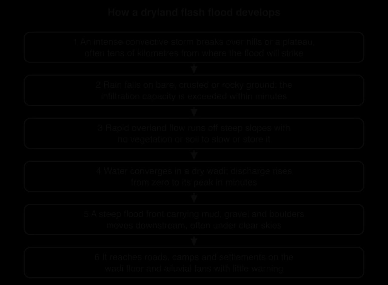
Desert surfaces are often bare rock, stony pavement or soil sealed by a crust of fine particles and salts, so their infiltration capacity is low and intense rain exceeds it within minutes. Water runs off as overland flow into dry valleys called wadis, where it speeds up over the smooth, dry bed. A flood front carrying mud and boulders can strike places tens of kilometres from the storm.
The danger is greatest where people build on wadi floors and alluvial fans. In Jeddah, Saudi Arabia, more than 70 mm of rain fell in four hours on 25 November 2009; at least eleven wadis converge on the city, and the floods killed 122 people, with more than 350 missing. In Derna, Libya, Storm Daniel’s rain caused both dams on Wadi Derna to fail on the night of 10–11 September 2023, releasing an estimated 30 million m³ of water through the city; official figures counted more than 7,800 dead or missing.
Climate graphs drawn on the same scales show how differently the three kinds of extreme environment behave.
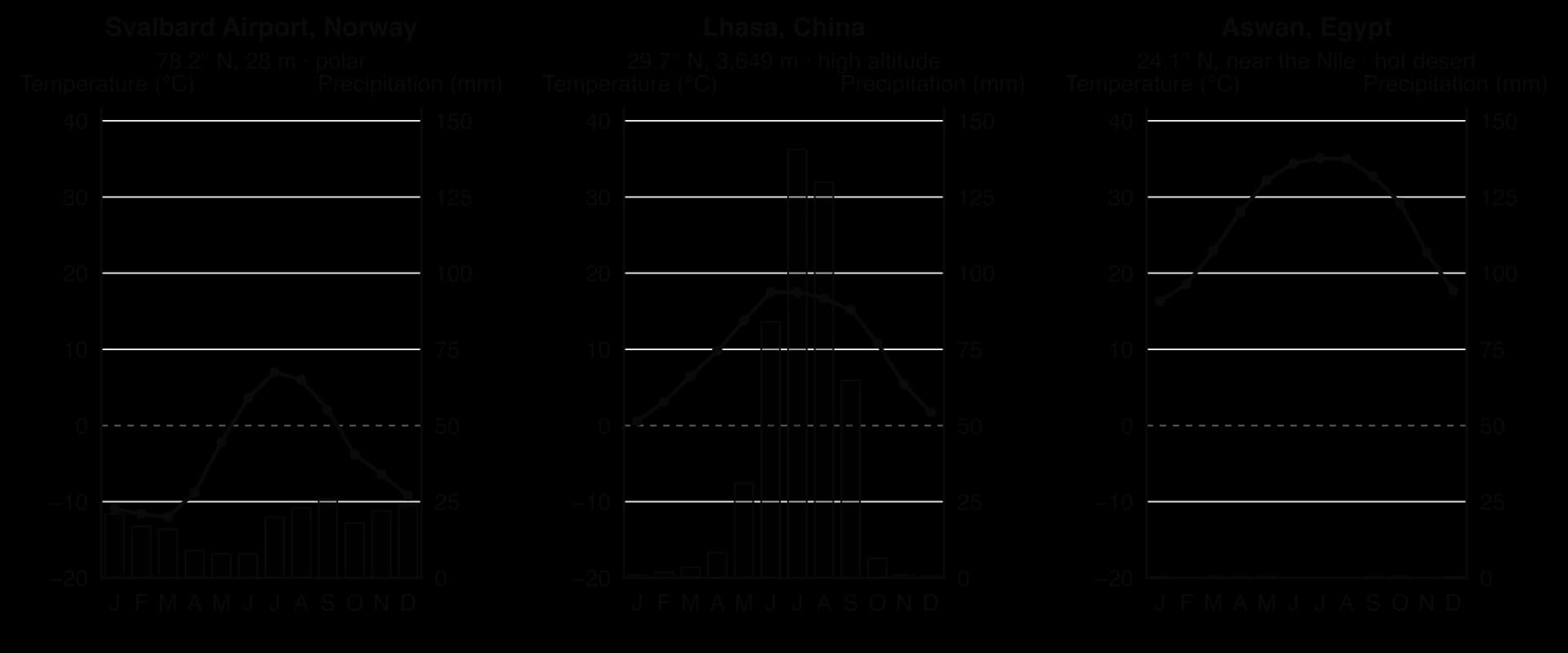
Svalbard Airport (polar) | Lhasa (high altitude) | Aswan (hot desert) | |
|---|---|---|---|
Warmest / coldest month | July 7.0 °C / March −12.0 °C | June–July 17.5 °C / January 0.6 °C | July 35.1 °C / January 16.3 °C |
Annual temperature range | 19.0 °C | 16.9 °C | 18.8 °C |
Annual precipitation | 212 mm, spread through the year | 473 mm, 88% in June–September | 2 mm |
Diurnal range (monthly means) | 3–7 °C | 11–16 °C | 13–15 °C |
All three have little or seasonal water but differ in what limits life: Svalbard is below freezing for eight months; altitude keeps Lhasa’s summers cool at the latitude of Cairo; in Aswan rainfall is effectively zero.
In cold environments, the steep, high relief of the Himalaya, Andes and Alps limits flat land, increases the risk of rockfall and avalanches, and forces roads and railways into long, costly routes. Ice sheets are crossed by crevasses, deep cracks often hidden by snow, and their surfaces lie at great heights.
In hot deserts, sand seas (ergs) such as the Grand Erg Oriental or the Rub’ al Khali shift with the wind and bury roads, and rocky plateaus, escarpments and gorges such as those of the Colorado Plateau block movement. In both, relief channels people into a few corridors (valleys, passes, oases and coasts), which helps to explain the nodal pattern of settlement.
Extreme environments hold valuable resources: minerals, oil and gas, grazing land, space for solar power and landscapes that attract tourists. Living in them and developing those resources is costly, because of five groups of challenge that act together: relief, climate, human discomfort, inaccessibility and remoteness.
Challenge | Polar and periglacial | High altitude | Hot arid |
|---|---|---|---|
Relief | Ice, crevasses; heave and subsidence over permafrost | Steep slopes, little flat land; avalanches, rockfall | Sand seas, escarpments, gorges; moving dunes |
Climate | Extreme cold, polar night, blizzards | Cold, low pressure, sudden storms, heavy snow | Heat, almost no rain, flash floods, dust storms |
Human discomfort | Hypothermia, frostbite, winter darkness | Altitude sickness, intense UV | Heat stress, dehydration |
Inaccessibility | Sea ice; seasonal ice roads | Passes closed by snow; winding routes | Few roads; sand seas |
Remoteness | Thousands of km from markets | Far from coasts and capitals | Long distances between oases and towns |
The leading problem differs: cold and frozen ground in polar areas, relief and low oxygen in mountains, water in deserts. Inaccessibility and remoteness are common to all three and raise the cost of overcoming every other challenge.
Steep slopes push mountain settlements onto valley floors, alluvial fans and terraces, often the places most exposed to floods and avalanches, and roads need tunnels, bridges and avalanche shelters. The Qinghai–Tibet railway, opened to Lhasa in 2006, crosses the Tanggula Pass at 5,072 m, the highest point on any railway, and about 550 km of it is laid on permafrost that the heat of passing trains could thaw. Engineers raised parts of the track on piled bridges and cooled others with ammonia-filled heat exchangers.
Climate raises the cost of almost everything. In the cold, buildings need insulation and constant heating, machinery must be built for low temperatures and construction is possible only in summer; frozen ground heaves and thaws, cracking buildings, pipelines and runways. In hot deserts the greatest cost is water, which must be pumped from deep aquifers, piped long distances or desalinated.
The body keeps its core temperature close to 37 °C. In the cold it can lose heat faster than it produces it, causing frostbite and hypothermia; in the heat it may be unable to lose heat fast enough, causing heat stress, which is most dangerous when humidity is high and people work outdoors. Weeks of polar darkness also disrupt sleep and mood.
In hot deserts the main danger is overheating and loss of water through sweating, which can lead to dehydration within hours for people working outdoors.
Inaccessibility is about how hard it is to get to a place physically; remoteness is about how far it is from where people, markets and decisions are concentrated.
Remoteness remains even where transport links are good.
Inaccessibility often varies with the seasons. Yakutsk, a city of 355,443 people (2021), lies on the west bank of the Lena River, and no bridge crosses the Lena anywhere in the Sakha Republic: its road link south is a ferry in summer and a road over the frozen river in midwinter, and in spring and autumn neither works. A road bridge more than 3 km long, about 40 km upriver, has been under construction since 2024, with completion planned for 2028. Remoteness is permanent: goods travel thousands of kilometres and workers expect high wages.
Countries dominated by extreme environments have some of the lowest population densities on Earth.
Country | Dominant extreme environment | Population density, 2023 (people per km²) |
|---|---|---|
Greenland | Ice sheet, tundra | 0.14 |
Mongolia | Gobi Desert, high steppe | 2.2 |
Australia | Hot desert and semi-arid interior | 3.5 |
Namibia | Namib and Kalahari deserts | 3.6 |
Libya | Sahara | 4.2 |
Egypt | Sahara, with the Nile valley | 115 |
World | — | 62 |
Sources: World Bank, World Development Indicators (FAO population estimates), indicator EN.POP.DNST, 2023 data, accessed 2026.
Averages hide concentration. About 95% of Egypt’s 118 million people (2025) live along the Nile, in its delta and beside the Suez Canal, while the Western Desert is almost empty. Settlement in extreme environments is typically nodal: oases in deserts, mining towns and ports in the Arctic, research stations in Antarctica.
People adapt through culture and knowledge, through technology and, over many generations, through physiology. Indigenous knowledge is the oldest of these adaptations and still supports many livelihoods.
Inuit: layered skin and fur clothing that traps warm air; snow houses (igloos) in Canada’s Central Arctic; knowledge of sea ice for travel and hunting.
Tuareg: traditionally nomadic pastoralists of the Sahara who move camels and goats between pastures and wells, spreading the risk of drought; the tagelmust veil protects against sun and sand.
Andean farmers: terraces (andenes) create flat fields on steep slopes and reduce soil erosion; potatoes and quinoa tolerate cold nights.
Highland physiology: Tibetans breathe more rapidly than lowlanders and have about twice as much nitric oxide in their blood, which aids blood flow; Andean highlanders adapt mainly in a different way, through higher concentrations of haemoglobin, which carries oxygen in the blood.
Modern technology: buildings on piles above permafrost, insulation, air-conditioning, desalination and air services.
Technology is powerful but expensive and depends on outside supplies; indigenous adaptations use local resources but are threatened when governments settle nomads or take land, a question of power.
At 4,900–5,100 m on the slopes of Mount Ananea, La Rinconada is the highest larger permanent settlement in the world. A rise of 235% in the price of gold between 2001 and 2009 swelled a prospectors’ camp to an estimated 30,000 people, although censuses count fewer (12,615 in the district in 2017), because many miners stay only for a season. Residents live with a mean annual temperature of 1.3 °C, and researchers estimate that at least a quarter suffer from chronic hypoxia (too little oxygen in the body tissues).
Resource development here shows how the challenges combine. Mercury used to process the ore contaminates the drinking water and a nearby glacier, and many miners work under the cachorreo system: 30 days without pay, then one day to keep whatever ore they can carry.
Yakutsk is the largest city built on continuous permafrost and the coldest city of over 200,000 people, with a January mean of −36.9 °C. Many buildings stand on concrete piles that keep their heat from thawing the ground. Mining drives its growth: the Sakha Republic, which is covered entirely by permafrost, produces 99% of Russia’s diamonds and over a quarter of the world’s.
McMurdo, run by the United States on Ross Island, is the largest community in Antarctica. It can house up to 1,200 people, and about 1,000 lived there in the summer of 2017, but only 153 stayed through the winter. No one is born or settles there permanently: every person, and almost all food and fuel, arrives by ship or aircraft during the short summer season.
Siwa lies in a depression of Egypt’s Western Desert about 19 m below sea level, 50 km east of the Libyan border, and had about 25,000 people in 2021. About 200 natural springs water thousands of date palms and olive trees, the basis of the local economy. Its isolation helped the Siwi, the easternmost Berber-speaking community, to keep a distinctive language and culture.
Alice Springs lies close to the geographic centre of Australia, on the land of the Arrernte people, about 1,500 km by road from both Darwin and Adelaide. With 24,855 people in its urban area in 2021, it is a service centre (hospital, schools, government offices, an airport) for a vast, thinly populated region and a base for tourism. Its remoteness raises the cost of goods and makes it hard to keep doctors, teachers and other workers.
Example | Environment | Leading challenge | Adaptation or response |
|---|---|---|---|
La Rinconada, Peru | High altitude (about 5,000 m) | Low oxygen, cold, no services | Seasonal migration of miners; informal mining |
Yakutsk, Russia | Periglacial (continuous permafrost) | Extreme cold; seasonal inaccessibility | Buildings on piles; ferry and ice road; bridge under construction |
McMurdo, Antarctica | Polar (ice-covered) | Cold, darkness, total dependence on supplies | Temporary research population; summer air and sea supply |
Siwa, Egypt | Hot desert (oasis) | Aridity and isolation | Spring-fed irrigation of dates and olives |
Alice Springs, Australia | Hot arid (semi-arid interior) | Remoteness | Regional service centre; air links |
The map of extreme environments changes over hundreds of thousands of years, as ice sheets grow and shrink, and over decades, as glaciers and desert margins shift.
The Quaternary period began about 2.58 million years ago and has been marked by repeated glacial periods, when ice sheets spread across the northern continents, and interglacial periods, when the ice retreated to roughly its present extent. For about the last million years each cycle has lasted about 100,000 years.
In each cycle the cold phase is long and the warm phase comparatively short.
Each glacial period ends with rapid warming, as the ice sheets melt back and sea level rises by more than 100 m.
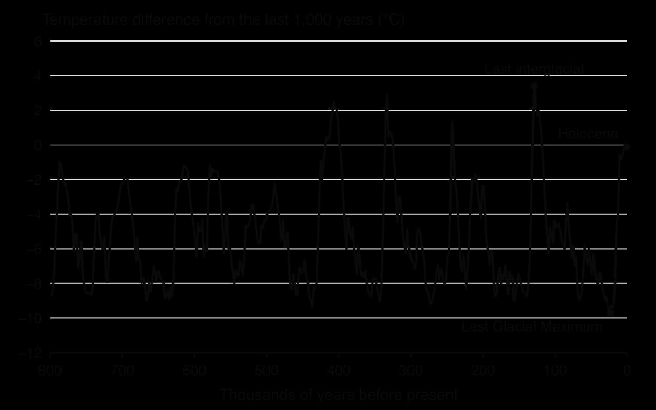
The pacemaker is the Milankovitch cycles, slow changes in the Earth’s orbit and tilt. The shape of the orbit (eccentricity) varies over about 100,000 and 405,000 years, the tilt (obliquity) between 22.1° and 24.5° over about 41,000 years, and the wobble of the axis (precession) over about 21,000–23,000 years. Together they change how much solar energy reaches high northern latitudes in summer; when summers there are cool, winter snow survives and ice sheets grow.
These orbital changes are too small on their own to explain the temperature swings, which are amplified by positive feedback. Growing ice sheets raise the Earth’s albedo, reflecting more sunlight, and colder oceans absorb more carbon dioxide, weakening the greenhouse effect. In a warming phase the same feedbacks work in reverse, which is why deglaciation is fast.
The most recent glacial period reached its greatest extent at the Last Glacial Maximum (LGM), between about 26,000 and 20,000 years ago. The global average temperature was about 6 °C lower than today and sea level about 120–125 m lower, joining Britain to Europe and western Indonesia to Asia.
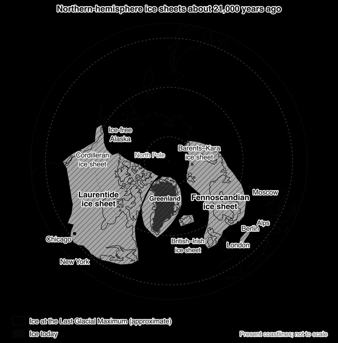
Beyond the ice, permafrost extended across much of Europe and North America and deserts expanded; on Kilimanjaro an ice cap of about 400 km² reached down to 3,200 m.
The Holocene, the present interglacial, began about 11,700 years ago. The Little Ice Age, dated either from the 16th to the 19th centuries or from about 1300 to about 1850, was a cool period in which Alpine glaciers advanced several times, with peaks around 1650, 1770 and 1850, overrunning farms and pastures.
Since about 1850 almost all mountain glaciers have retreated, and glacier retreat has accelerated since the 1980s. Glaciers respond to their glacier mass balance, the difference between snow gained and ice lost each year: when it is negative for many years, the glacier thins and its snout retreats. Swiss glaciers lost 6% of their volume in 2022 and 4% in 2023, as much in two years as in the thirty years from 1960 to 1990.
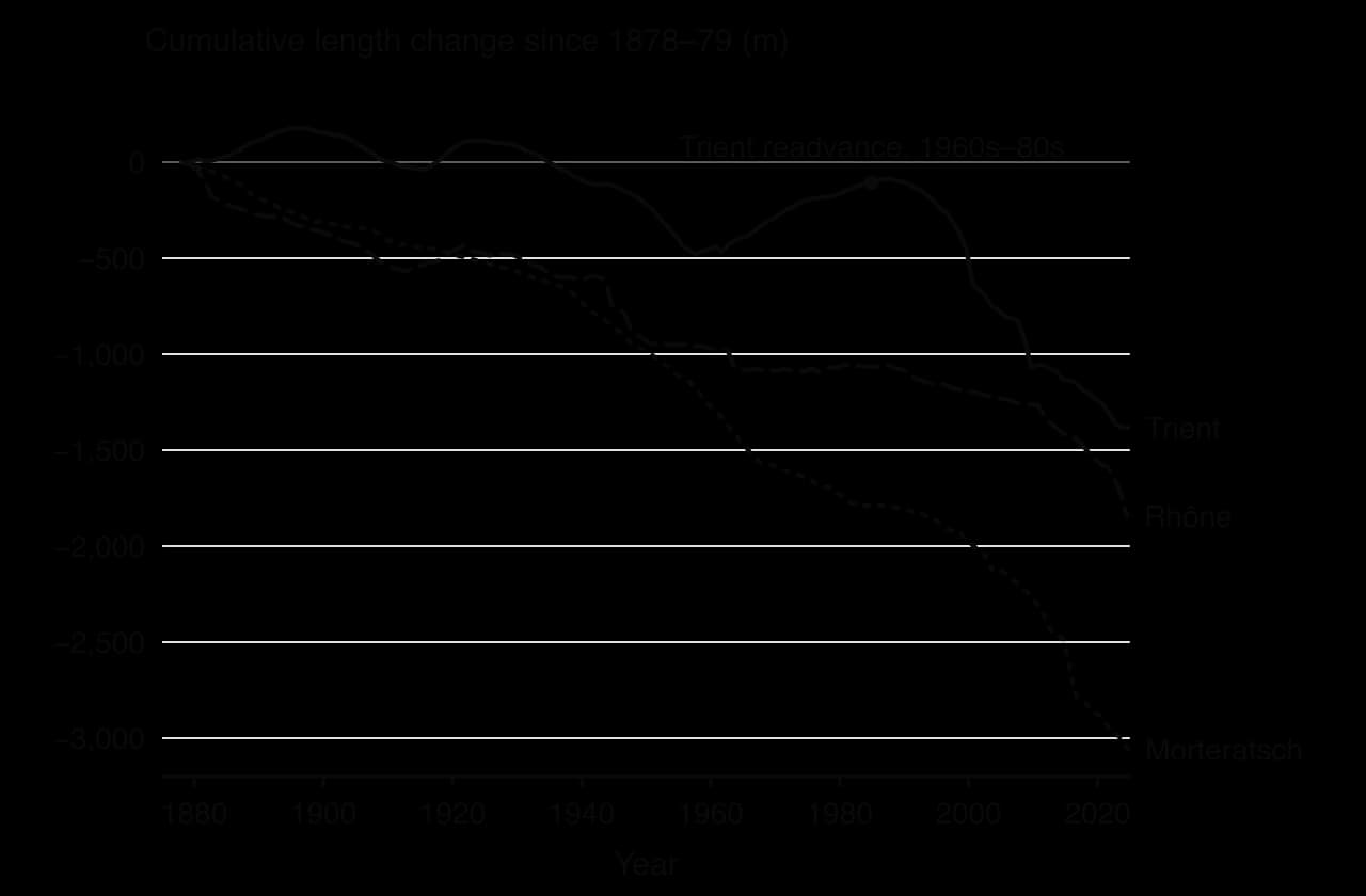
By 2024 the Morteratsch Glacier had retreated about 3,060 m, the Rhône Glacier about 1,845 m and the Trient Glacier about 1,384 m. The short, steep Trient readvanced for decades after runs of snowy winters and cool summers, while larger glaciers respond more slowly and smooth out such variations. Tropical glaciers are especially sensitive: almost 85% of the ice on Kilimanjaro disappeared between 1912 and 2011, and the Chacaltaya glacier in Bolivia, 0.22 km² in 1940, had vanished by 2009, ending what had been the world’s highest lift-served ski area.
The World Glacier Monitoring Service collects measurements from about 60 reference glaciers worldwide that have continuous records of more than 30 years. Their mean annual mass balance was about −1.3 m water equivalent in both 2023/24 and 2024/25 (provisional), and their average cumulative thinning since 1980 is more than 25 m water equivalent. The largest glacier in the Alps, the Great Aletsch, has retreated more than 3 km since the 1870s.
During the African Humid Period, from about 14,500 to between 6,000 and 5,000 years ago, much of the Sahara was grassland and savanna with lakes. Lake Chad was far larger, and rock paintings show herds of cattle where there is now almost no water. Orbital changes had strengthened the summer heating of North Africa and drawn the monsoon far north.
The end of the period shows feedback turning gradual change into rapid change. As the monsoon weakened, vegetation thinned; bare sand reflects more sunlight and fewer plants return moisture to the air, both weakening rainfall further. People moved towards the Nile valley and Mesopotamia.
Desert margins also shift over decades. In the Sahel, annual rainfall was 20–40% lower in 1968–1990 than in 1931–1960, and recovered slightly from the mid-1990s in some areas. In parts of the Sahel vegetation has since recovered, a partial “re-greening” seen on satellite images. Such natural variation makes it hard to separate climatic causes from the human causes of desertification.
Longyearbyen, at 78° 13′ N, is the largest settlement and administrative centre of Svalbard, a Norwegian archipelago in the Arctic Ocean, and one of the northernmost towns in the world. It lies at the mouth of the Longyear Valley on Adventfjorden, on the west coast of Spitsbergen. Glacier ice covers about 60% of Svalbard, 30% is bare rock and only 10% has vegetation. It shows how relief, climate, permafrost and remoteness combine to limit habitation.
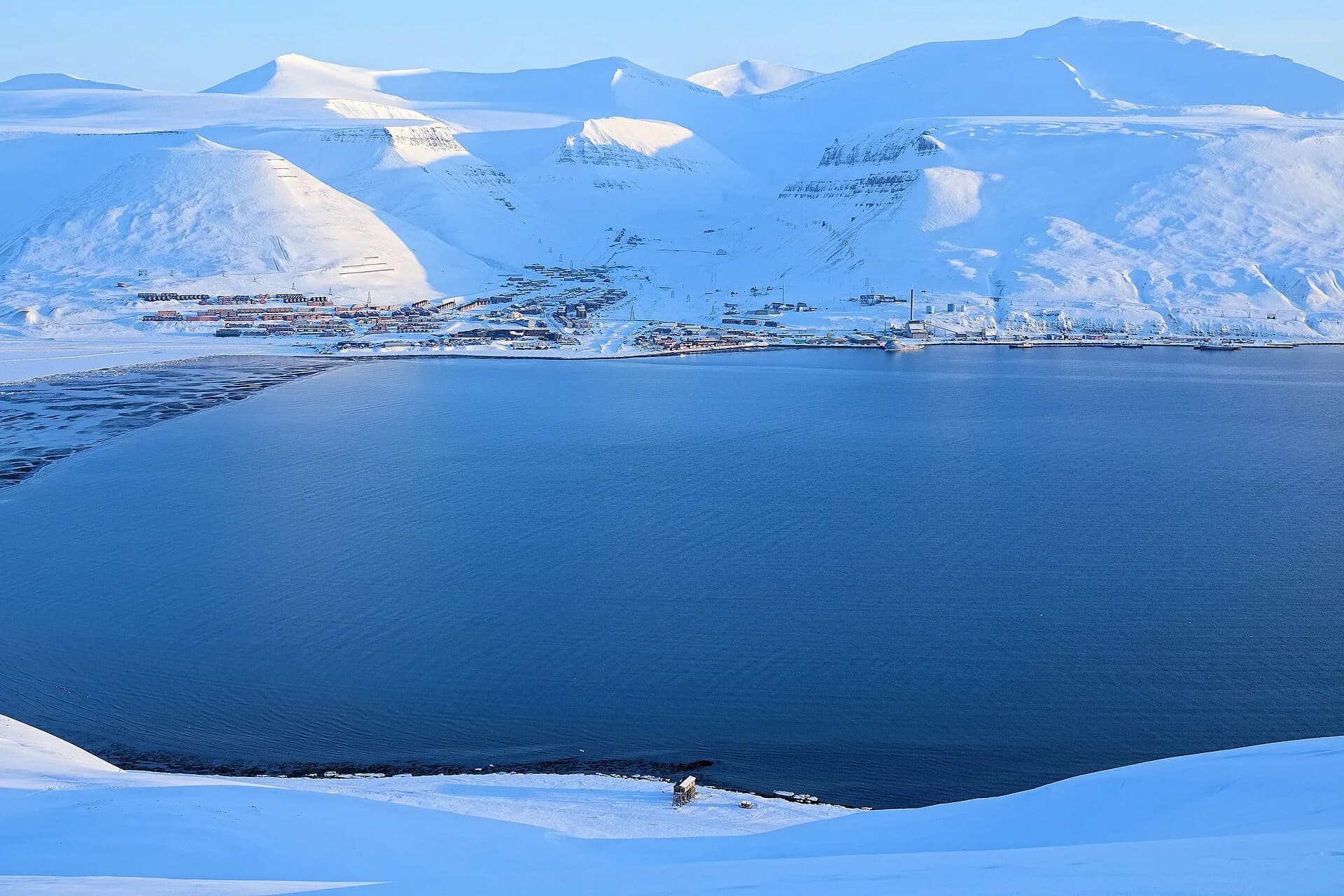
Longyearbyen was founded in 1906 by the American Arctic Coal Company and later run by the Norwegian mining company Store Norske, which the state owned almost entirely from 1976. The Svalbard Treaty of 1920 recognised Norwegian sovereignty and made the archipelago a free economic zone.
In 2020 the tax office registered 2,354 residents, a young and mobile population: in 2022, 43% had lived there for less than two years. The economy has shifted from coal to research, education and tourism: the University Centre in Svalbard has about 350 students, the Global Seed Vault opened in 2008, and Norway closed Mine 7, its last coal mine on Svalbard, on 30 June 2025.
At Svalbard Airport the mean temperature is below 0 °C from October to May and annual precipitation is 212 mm. The polar night lasts 111 days, from 27 October to 15 February, and the midnight sun 128 days, from 18 April to 24 August. The record temperatures are 21.7 °C (July 2020) and −46.3 °C (March 1986).
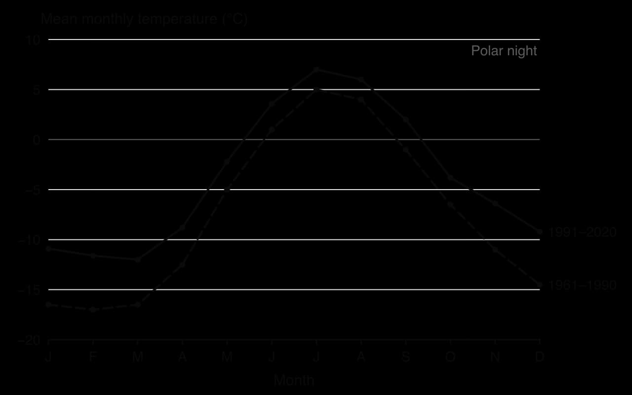
The climate is changing faster than almost anywhere on Earth. The 1991–2020 mean was 3.6 °C higher than that for 1961–1990; since 1971 Svalbard has warmed by about 4 °C, five times the global rate, and winters are more than 7 °C warmer than in the 1970s. Precipitation has risen by 30–45% in fifty years, mostly as winter rain. Warming is greatest in early winter, because warmer seas delay the formation of sea ice and the open water releases heat during the polar night.
Steep mountains rise directly behind the town. On 19 December 2015, during a storm, an avalanche from the mountain Sukkertoppen swept eleven houses on the street Vei 230 from their foundations, killing a child and a man in his forties and injuring nine; neighbouring streets and the whole of Nybyen were evacuated and a further row of houses was condemned. The disaster showed how little safe building land lies between the fjord and the slopes.
The town stands on permafrost. Since 1950 the dead have not been buried there, because bodies do not decompose in frozen ground; victims of the 1918 influenza pandemic were found preserved. Since 2009 the deep permafrost has warmed by 0.06–0.15 °C a year, raising the risk of subsidence and slope failure.
Longyearbyen is about 960 km from Tromsø and 2,040 km from Oslo, the mainland cities with direct flights. Its 50 km of roads connect to no other settlement: the Russian mining town of Barentsburg, 45 km away, is reached by snowmobile in winter or by ship. Supplies arrive by sea or air, so living costs are high, and residents are advised to carry a rifle outside the town for protection against polar bears.
Key concept | How the case shows it |
|---|---|
Place | Latitude 78° N, a fjord-side valley, permafrost and avalanche slopes limit where and how people live |
Process | Sea-ice feedback, permafrost warming and avalanching change the hazards the town faces |
Power | The Norwegian state holds sovereignty, owns about 95% of the land and chose to end coal mining, so the town depends on national policy |
Possibility | Further warming may bring more winter rain, landslides and thaw subsidence, but also longer seasons for research and tourism |
Longyearbyen is extreme in almost every sense, yet it is a modern town sustained by technology and money from the state, research and tourism, and its limiting hazards are growing as its climate changes.
 YouTube
The Atacama is a strip about 1,600 km long in northern Chile, between the Pacific and the Andes. Under the subtropical high, beside the cold Humboldt Current and between the Andes and the Coast Range, it receives about 15 mm of rain a year on average, and parts of its central sector, between Antofagasta, Calama and Copiapó, have gone up to four years without rain. Where Longyearbyen is limited by cold, darkness and ice, the Atacama is limited by water.
Its settlements are therefore nodal: ports and cities on the coast such as Antofagasta, inland mining towns such as Calama beside the Chuquicamata copper mine, and oases such as San Pedro de Atacama at about 2,400 m. About 170 abandoned nitrate towns show how settlement collapsed when the resource that justified it lost its market. Rare storms bring the hazard that dryness hides: the 1991 mudflows in Antofagasta and Taltal killed 91 people.
Explain which of the five challenges most limits the growth of Longyearbyen.
Suggest why warming may make Longyearbyen both easier and more dangerous to live in.
To what extent is Longyearbyen’s population a permanent community?
Sources: Norwegian Meteorological Institute (climate normals 1961–1990 and 1991–2020); Scientific American (2021); Longyearbyen Tax Office (2020); Statistics Norway via Wikipedia (2022); Norwegian Wikipedia, “Snøskredet i Longyearbyen 2015”, accessed 2026.
Structured questions on extreme environments often begin with a world map, climate graph or climate table; extended questions ask you to examine causes of extremeness or evaluate challenges, with detailed examples from both kinds of environment.
The structured question uses real climate data for Alice Springs, Australia (23.8° S, 545 m), 1991–2020 averages.
J | F | M | A | M | J | J | A | S | O | N | D | |
|---|---|---|---|---|---|---|---|---|---|---|---|---|
Mean daily maximum (°C) | 37.1 | 35.8 | 33.5 | 29.3 | 23.6 | 20.1 | 20.7 | 23.5 | 28.8 | 31.9 | 34.4 | 35.7 |
Mean daily minimum (°C) | 22.3 | 21.1 | 17.9 | 12.9 | 8.0 | 4.7 | 3.9 | 5.8 | 11.2 | 14.9 | 18.3 | 20.7 |
Mean rainfall (mm) | 48.9 | 40.7 | 19.9 | 19.9 | 17.5 | 10.3 | 13.0 | 3.8 | 7.8 | 18.7 | 33.0 | 41.3 |
Sources: Australian Bureau of Meteorology, Alice Springs Airport 1991–2020, via Wikipedia, accessed 2026.
Extended answers are marked against the 10-mark markband: the top band needs well-evidenced examination of the question’s main themes and a critical conclusion grounded in geographical concepts or perspectives.
Extreme environments are places where climate and relief severely limit plants, people and economic activity; “extreme” is a human-centred label.
Cold and high-altitude environments include polar areas, ice sheets and ice caps, periglacial tundra over permafrost and high mountains; glaciers cover about 10% of land.
Hot deserts and semi-arid areas are defined by aridity (P ÷ PET), not rainfall alone; drylands cover 41.3% of land and are home to more than 2 billion people.
Most hot deserts lie near 30° N and S under the sinking air of the Hadley cells; others result from continentality, rain shadows and cold ocean currents.
Cold environments are extreme through low temperatures, polar night, low precipitation, katabatic winds and wind chill; high mountains through the lapse rate, low pressure, UV and steep relief.
Desert rainfall is low, highly variable and intense; flash floods develop when intense rain falls on bare, low-infiltration surfaces and is channelled into wadis.
Relief, climate, discomfort, inaccessibility and remoteness challenge habitation and resource development; settlement is sparse and nodal.
Extreme environments change over time: Quaternary glacial cycles paced by Milankovitch cycles and amplified by feedbacks, the Little Ice Age, glacier retreat since about 1850 and natural shifts of the Sahara and Sahel.
I can describe the global distribution of cold, high-altitude and hot arid environments with latitudes and named examples.
I can explain the four causes of hot deserts with a named example of each.
I can distinguish arid from semi-arid environments using the aridity index.
I can explain the climatic and relief characteristics that make each kind of environment extreme.
I can explain how a flash flood develops in a dryland, with a located example.
I can interpret a climate graph and determine annual and diurnal temperature ranges and the coefficient of variation.
I can examine the challenges of relief, climate, discomfort, inaccessibility and remoteness with detailed examples.
I can explain how glacial cycles, glacier retreat and natural desertification have changed the distribution of extreme environments.
Time: relict periglacial features (eg ice-wedge casts and blockfields in Britain; Cairngorm summit features) record past climates, while active features occur today in the Arctic.
Good answers may be well structured (AO4) and may additionally offer a critical evaluation (AO3) which considers scale: regional patterns are mainly climatic (latitude, altitude, continentality), while local variations are due to slope, aspect, drainage and sediment. Another approach might be to rank the factors, or to argue that they interact (eg water availability depends on both climate and the impermeability of the permafrost). Some answers may consider change over time, as warming shifts the southern limit of permafrost northwards and makes thaw features more common (possibilities).
For 5–6 marks, expect some weakly-evidenced outlining of one or more reasons for variations in periglacial features.
For 7–8 marks, expect a structured account which includes:
either well-evidenced explanation of two or more reasons why periglacial features vary, with reference to named places
or a discursive conclusion (or ongoing evaluation) of the relative importance of these reasons, grounded in geographical concepts and/or perspectives.
For 9–10 marks, expect both of these traits.
NB. Maximum [4] if the response only describes periglacial features without explaining why they vary.
Marks | Level descriptor |
|---|---|
0 | The response does not reach a standard described by the descriptors below. |
1–2 | Too brief, lists unconnected information, not focused on the question and lacks structure. Knowledge is very general, with large gaps or errors; examples or case studies are missing or only listed. No analysis; terminology is missing or used incorrectly. |
3–4 | Too general, lacks detail, not focused on the question and largely unstructured. Outlines examples, statistics and facts, both relevant and irrelevant, with links to the question only listed. Basic terminology is used, with errors or inconsistently. No critical evaluation of evidence; any conclusion is irrelevant. |
5–6 | Partially addresses the question, with a narrow argument, an unsubstantiated conclusion and limited evaluation. Describes relevant supporting evidence (examples, case studies) and outlines links to the question. The argument repeats one point or covers only part of the question. Other perspectives, or strengths and weaknesses of evidence, are listed. |
7–8 | Addresses the whole question; the analysis is evaluated and the conclusion is relevant but lacks balance. Relevant evidence is described correctly and covers all the main points. The argument is clear but one-sided or unbalanced. Complex terminology is used correctly but not consistently. Other perspectives, or strengths and weaknesses of evidence, are described. |
9–10 | In-depth and specific to the question (topic and command term). Correct, relevant examples, statistics and detail are integrated and their link to the question explained. The argument is balanced, explaining complexity, exceptions and comparisons. Evaluation of evidence and perspectives is well developed, and the conclusion is balanced and aligned with the evidence. Logically structured and easy to follow. |
Examine the relative importance of atmospheric circulation and ocean currents in explaining the global distribution of hot, arid environments.
10 marks
Examine the reasons why cold environments are found both at high latitudes and at high altitudes in non-polar places.
10 marks