B Oceans and coastal margins
See how the four parts of Oceans and coastal margins fit together, from ocean–atmosphere systems and coastal processes to coastal management and the oceans as a contested global commons.
- IB Geography
- SL and HL
What B covers
From the subject guide: what you need to know and be able to do.
Option: how oceans, the atmosphere and coasts interact, and how coasts and oceans are managed.
4 subtopics in Oceans and coastal margins
Each one has its own page once something is published for it.
- B.1Ocean–atmosphere interactions55 questions · notes
- B.2Interactions between oceans and coastal places66 questions · notes
- B.3Managing coastal margins68 questions · notes
- B.4Ocean management futures66 questions · notes
An overview of B Oceans and coastal margins
Oceans and coastal margins studies the physical ocean and its links with the atmosphere, the processes that shape coasts, and the ways in which coasts and seas are valued, used, managed and fought over. The oceans cover about 71% of the Earth’s surface, absorb about a quarter of the carbon dioxide released by human activity and carry over 80% of world trade by volume, while about 40% of the world’s people live in coastal zones.
Questions that frame the option
The option follows four lines of geographical inquiry. The first asks how physical processes link the oceans and the atmosphere, moving heat, water and carbon around the planet. The second asks how coastal places are shaped by their interactions with the sea. The third asks why different stakeholders have such different power over how a coast is managed. The fourth asks what futures are possible for the oceans as a resource shared by all states.
These inquiries lead to real questions that geographers try to answer with evidence:
Why did Hurricane Melissa in 2025 cause damage estimated at between 40% and 55% of Jamaica’s annual output, when the far costlier Hurricane Katrina cost the USA only about 1% of its GDP?
Why is the Holderness coast eroding fastest just south of the towns that are protected by sea defences?
Why is North Jakarta sinking ten to twenty times faster than the global sea is rising, and can a sea wall save it?
Why did the Grand Banks cod not return for decades after Canada stopped fishing in 1992?
Why did the 2016 arbitral award on the South China Sea not end the dispute?
What the option covers
The option has four subtopics. The first two are physical; the last two deal with management, law and geopolitics.
Subtopic | Main question | Case study and detailed examples |
|---|---|---|
B.1 Ocean–atmosphere interactions | How do currents, ENSO and hurricanes link the oceans and the atmosphere, and how does the ocean store carbon? | Case study: Hurricane Melissa, Jamaica, 2025. Examples: upwelling and the Peruvian anchoveta, El Niño and La Niña events (the 2015 South-east Asian haze, the 2010–2011 Queensland floods), the weakening AMOC, coral bleaching on the Great Barrier Reef |
B.2 Interactions between oceans and coastal places | How do waves, tides, sediment supply, rock type and sea-level change create coastal landforms? | Case study: the Holderness coast, England, with Spurn Head. Examples: Old Harry Rocks and the Twelve Apostles, Chesil Beach, Sognefjord, the Stockholm and Newlyn tide gauges, the dunes at Studland |
B.3 Managing coastal margins | Who decides how a coast is protected, which uses it serves and who controls the sea beyond it? | Case study: Jakarta (subsidence, sea walls and moving the capital). Stakeholder example: the Gold Coast, Australia. Detailed examples: the Great Barrier Reef and the Sundarbans. Examples: Mappleton, Medmerry, Happisburgh, the Thames Barrier |
B.4 Ocean management futures | Can ocean resources be used, polluted and fought over without destroying the global commons? | Case study: the South China Sea. Examples: Deepwater Horizon, the Clarion–Clipperton Zone, the Grand Banks cod, the Fukushima discharge, the Great Pacific Garbage Patch, choke points such as Hormuz and Bab-el-Mandeb |
The Great Barrier Reef shows how the subtopics overlap: its bleaching is a result of ocean warming and ocean acidification in the first subtopic, while the zoning of its marine park and the Reef 2050 Plan belong to coastal management in the third.
How the subtopics connect
The concept map shows the main links as a cycle. The ocean–atmosphere system sends storms, surges and rising seas against the coast, so the processes of the first subtopic shape the coastal places of the second. Within a sediment cell, longshore drift links one stretch of coast to the next, so defences built in one place change the sediment supply further along it, which is the starting point of coastal management. Beyond the shore, the law of the sea divides the water into zones that end at the high seas, the subject of the fourth subtopic, whose fish stocks depend in turn on the upwelling and currents of the first.
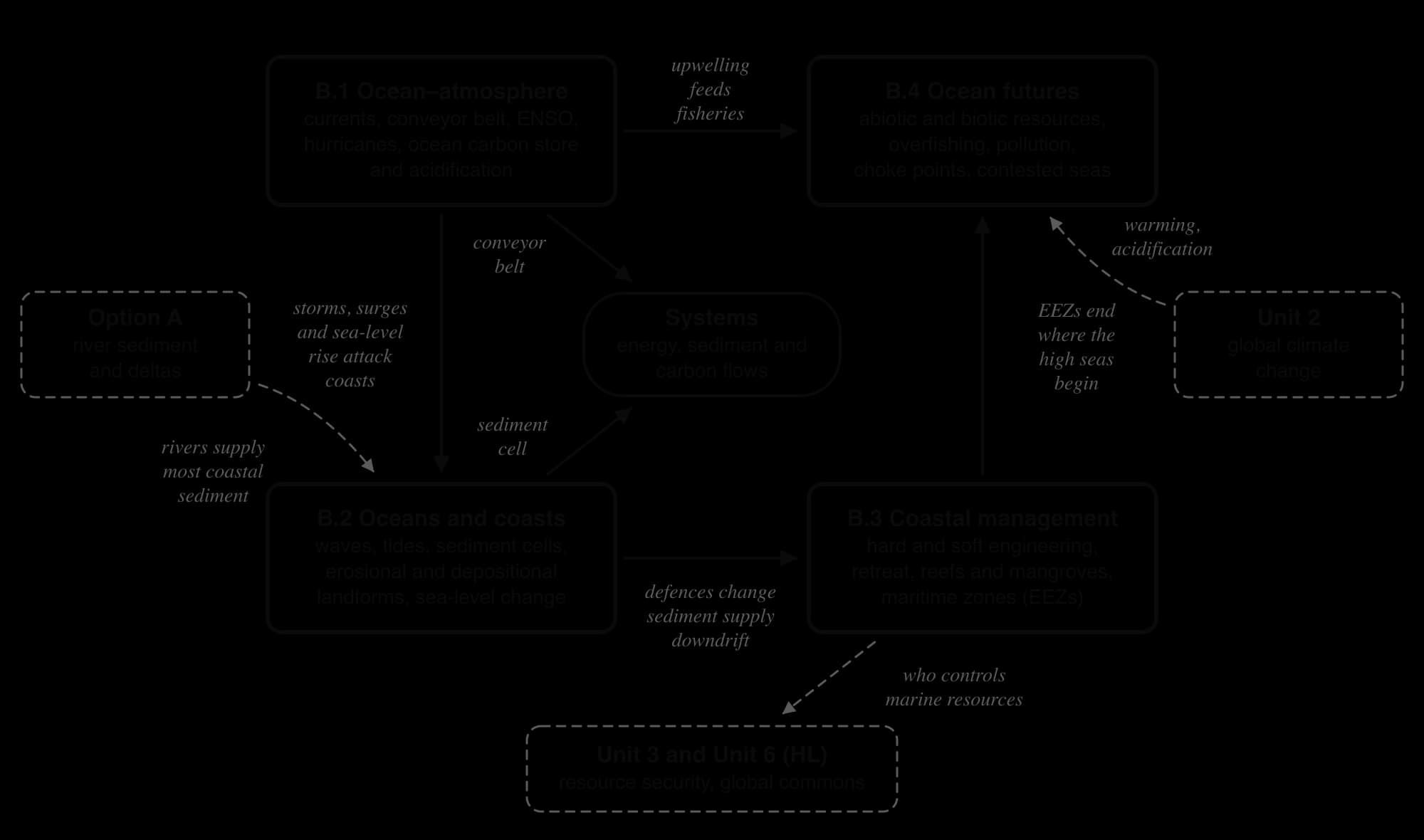
Change in one part of the ocean or coast causes change elsewhere. El Niño–Southern Oscillation warms the eastern Pacific and dries Indonesia through teleconnections; the groynes at Mappleton cut erosion at the village but increased it on the cliffs to the south; plastic released on land collects in a garbage patch at the centre of an ocean gyre. These spatial interactions, at every scale from a single beach to the whole planet, connect all four subtopics.
Key concepts in Oceans and coastal margins
The four key concepts run through the option, together with three concepts that belong to it in particular: systems, territories and the global commons.
Concept | How it appears in the option |
|---|---|
Process | The Walker circulation and ENSO, latent heat release in a tropical cyclone, wave refraction and longshore drift, the chemistry of acidification. |
Place | The same rising ocean gives falling relative sea level at Stockholm and rising sea level at Newlyn; Hurricane Katrina caused ten times Melissa’s damage in money, but about 1% of US GDP against more than half of Jamaica’s. |
Power | National governments, developers and investors against informal residents in Jakarta; China against the Philippines at Scarborough Shoal; distant emitters against reef and island states. |
Possibility | Forecasts of ENSO and hurricanes, a possible collapse of the AMOC, managed realignment as sea level rises, the High Seas Treaty and a global plastics treaty. |
Systems | The global ocean conveyor belt moving heat, carbon and nutrients; coastal landform systems and sediment cells with their sources, transfers and sinks. |
Territories | The zones of the United Nations Convention on the Law of the Sea: territorial sea, contiguous zone and exclusive economic zone, and disputes over islands, rocks and artificial islands. |
The global commons | The high seas and the deep seabed, shared by all and exposed to the tragedy of the commons through overfishing and pollution. |
The option links closely to the core. The ocean is the largest active carbon store and a carbon sink, so its changing role is part of the unit on global climate change, along with sea-level rise, marine heatwaves and stronger tropical cyclones; after Hurricane Melissa, Jamaica’s ministers told the UN climate conference in November 2025 that a country with tiny emissions bears the costs of storms fed by a warming ocean.
Fish, offshore oil and gas and the choke points of world shipping belong to the unit on resource security, through food security and energy security. Rivers supply most of the sediment that reaches coasts, which links coastal landforms to Freshwater, and the high seas as a global commons link the option to the environmental risks studied at HL.
How SL and HL differ
Oceans and coastal margins is one of seven options. SL students choose two options and HL students choose three. The content of the option is identical at both levels: every subtopic, case study and skill is studied in the same depth, and nothing on the option’s pages is HL only.
Both levels answer the same Paper 1 question on the option, marked with the same markbands. SL and HL differ only in the number of options studied and in the HL extension units, which HL students take in addition.
Assessment
Oceans and coastal margins is examined in Paper 1. For each option studied there is a structured question built on a stimulus, worth 10 marks, followed by one extended answer worth 10 marks, chosen from two. The structured question typically has four parts: (a)(i) and (a)(ii), one mark each, read a value or fact from the stimulus; (b), two marks, asks for an outline of one cause or effect; and (c), three marks plus three, asks for two developed explanations.
Stimuli for this option are often maps of ocean currents or hurricane tracks, an Oceanic Niño Index time series, beach profiles or cliff-retreat data, photographs of coastal landforms, or maps of maritime zones. Typical short questions ask candidates to identify a current, state a direction of longshore drift, outline how a groyne affects a beach or explain two impacts of a storm surge. Extended questions usually offer one physical theme, such as the formation of spits or wave-cut platforms, and one management theme, such as the effectiveness of hard engineering or the management of the oceans as a global commons.
Carry on with B in Augment
With a free account, Augment remembers where you stopped and what you have practiced.