Explain how plate movement, magma type, fault rupture and slope forces produce earthquakes, volcanic eruptions and mass movements of different types and sizes, with their secondary hazards and real data.
Each is in the Geography glossary, with every other term in the subject.
The weak, partly molten layer of the upper mantle beneath the lithosphere, on which the rigid plates move.
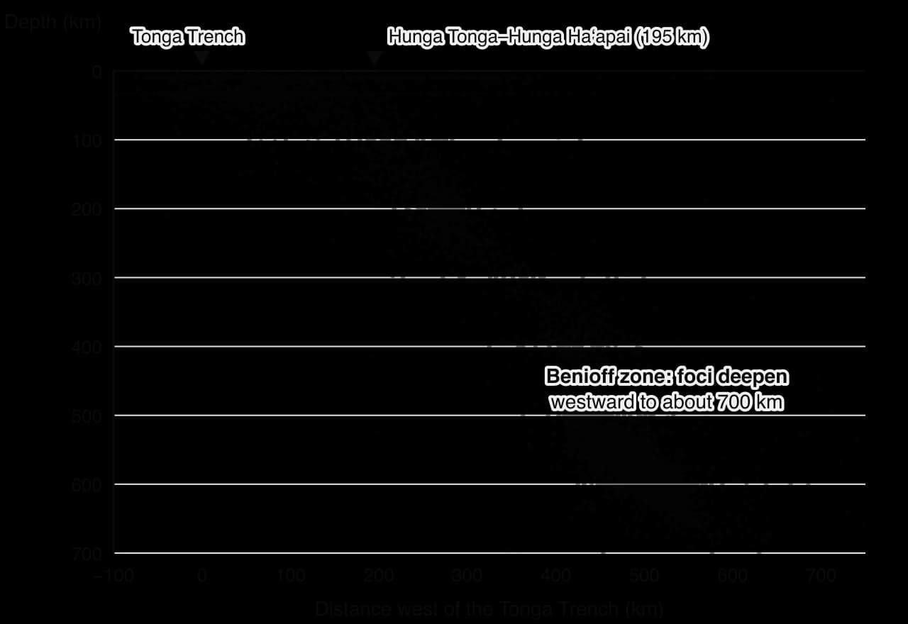
The zone of earthquake foci that dips from the trench into the mantle along a subducting plate, reaching depths of up to about 700 km.
A small, steep volcanic cone built from loose fragments of tephra, usually during a single short-lived eruption.
A steep-sided cone built from alternating layers of ash and lava erupted from viscous magma, often explosively, such as Mount Fuji.
The thick, less dense layer of mainly granitic rock, about 25–70 km thick, that forms the continents; it is too buoyant to subduct and parts are about 4 billion years old.
A circulation in which hot, less dense material rises, spreads and cools, then sinks again; in the mantle it transfers heat outward over millions of years.
A plate boundary where two plates move towards each other, so that one plate subducts or the crust is crumpled in a collision.
A fast-moving, water-saturated mixture of mud, rock and vegetation that flows downslope, often along a channel.
Describe the internal structure of the Earth and distinguish between oceanic and continental crust, and between the lithosphere and the asthenosphere.
Explain how internal heating, mantle convection, mantle plumes, slab pull and ridge push move tectonic plates.
Explain subduction and rifting, and compare the landforms, earthquakes and volcanoes of each type of plate boundary and of hotspots.
Explain how magma type controls eruption style, and distinguish between shield volcanoes, composite volcanoes and cinder cones.
Describe the primary and secondary hazards of volcanoes, including pyroclastic flows, lahars and flank collapse.
Describe the characteristics of earthquakes and explain how they vary with plate boundary type and human triggers.
Explain how tsunamis, landslides, liquefaction and surface rupture develop as secondary hazards of earthquakes.
Classify mass movements by cause, liquidity, speed of onset, duration, extent and frequency, and evaluate these classifications.
Analyse real data on plate movement and earthquake depths, including a Benioff zone cross-section.
Geophysical systems are the processes inside and at the surface of the solid Earth that produce earthquakes, volcanic eruptions and mass movements. Every geophysical hazard begins with one of them: heat escaping from the interior keeps the plates moving, and gravity acts on the slopes their movement builds.
The topic is above all about process: the chain of cause and effect that links heat deep in the mantle to a lava flow, a tsunami or a landslide. It also introduces place, because the type and size of event a location can experience depend on its position relative to plate boundaries, its rocks and its slopes.
81 exam-style questions on this subtopic, written in the style of the IB papers. The first has its markscheme open. Counted on
Examine the relationship between plate boundary processes and the global distribution of earthquake and volcanic hazards.
10 marks
Marks should be allocated according to the markbands.
The question asks how processes at constructive (divergent), destructive (convergent) and conservative (transform) plate boundaries explain where earthquakes and volcanoes occur. Distribution may be described at the global scale (belts, clusters and gaps) and explained through the processes operating at each boundary type. Hotspots (intraplate volcanism) and intraplate earthquakes should be credited as exceptions to the relationship. The focus is on the hazards, so answers should link the distribution of the physical events to where they pose a risk.
Possible applied themes (AO2) demonstrating knowledge and understanding (AO1):
The Pacific Ring of Fire contains roughly three-quarters of the world’s active volcanoes and is the setting for about 90% of earthquakes; this reflects subduction of oceanic plates around the Pacific (eg the Pacific Plate beneath Japan, the Nazca Plate beneath South America).
Subduction zones generate the largest (megathrust) earthquakes, eg Chile 1960 (M9.5), Indian Ocean 2004 (M9.1), Tōhoku 2011 (M9.0), and explosive andesitic or rhyolitic volcanoes because melting of the subducted slab produces viscous, gas-rich magma (eg Pinatubo 1991, Merapi).
Continental collision zones (Alpine–Himalayan belt) produce frequent shallow and intermediate earthquakes over wide areas but little volcanism, as no oceanic crust is subducted (eg Nepal 2015, Kashmir 2005, Türkiye 2023 lies at the junction of collision and transform movement).
Conservative boundaries produce shallow earthquakes but no volcanoes (eg the San Andreas Fault, California; the North Anatolian Fault, Türkiye; the Enriquillo–Plantain Garden fault zone, Haiti 2010).
Constructive boundaries produce frequent, low-magnitude, shallow earthquakes and effusive basaltic eruptions; most lie under the ocean, so the hazard to people is limited except where ridges rise above sea level (eg Iceland: Eyjafjallajökull 2010, the Reykjanes peninsula eruptions near Grindavík from 2023) or at continental rifts (eg East African Rift: Nyiragongo, Goma).
With a free account, Augment remembers where you stopped and what you have practiced.
The distance from the Earth's surface down to the focus of an earthquake, classed as shallow (0–70 km), intermediate (70–300 km) or deep (300–700 km).
A plate boundary where two plates move apart and new crust forms from rising magma, as at mid-ocean ridges and continental rifts.
A volcanic eruption in which low-viscosity magma flows out gently as lava because gases escape easily.
An explanation of earthquakes in which rocks on either side of a locked fault bend as stress builds, then break and spring back, releasing energy as seismic waves.
The point on the Earth's surface directly above the focus of an earthquake, usually close to where the shaking is strongest.
A volcanic eruption in which gas trapped in viscous magma expands violently, shattering the magma into ash and tephra.
A fracture in the Earth's crust along which rocks on either side have moved relative to each other.
The sudden collapse of a large part of a volcano's side, producing a fast debris avalanche and sometimes a tsunami.
The point inside the Earth where a fault first ruptures and an earthquake begins, and from which seismic waves spread out.
An area of volcanic activity fed by a mantle plume, often far from a plate boundary, such as Hawaii or Yellowstone.
The heat generated inside the Earth by the radioactive decay of uranium, thorium and potassium isotopes, together with heat left over from the planet's formation.
A volcanic mudflow of ash, rock and water, formed by heavy rain or melting ice, that follows river valleys far from the volcano.
The everyday term for the rapid downslope movement of rock, soil or debris, used for most falls, slides and flows.
A process in which shaking raises the pore-water pressure in saturated sand or silt so much that it loses strength and behaves like a liquid.
The water content of the material in a mass movement, from dry falls and slides to wet flows; one of the criteria used to classify mass movements.
The rigid outer shell of the Earth, made of the crust and the uppermost mantle, about 100 km thick on average and broken into tectonic plates.
A narrow column of unusually hot rock rising from deep in the mantle that melts as it nears the surface and produces a hotspot.
The downslope movement of rock, soil or debris under the influence of gravity, from very slow creep to sudden falls and flows.
A very large earthquake on the gently dipping fault between a subducting plate and the overriding plate, which can exceed magnitude 9.
A scale from I to XII that measures the intensity of earthquake shaking at a place from what people feel and the damage it causes.
A logarithmic scale that measures the energy released by an earthquake from the fault area, the slip and the rock strength; each whole number is about 32 times more energy.
A fast flow of fine-grained, water-saturated material such as clay and silt down a slope or channel.
The thin, dense layer of basaltic rock, about 5–10 km thick, that forms the floor of the ocean basins; it is younger than about 200 million years because it is recycled at subduction zones.
A compressional seismic wave that pushes and pulls rock in its direction of travel; it is the fastest wave and passes through solids and liquids.
The zone where two tectonic plates meet and move relative to each other, where most earthquakes and volcanoes occur.
The pressure of water held in the spaces between particles of soil or rock; when it rises it pushes the grains apart and reduces friction.
A hazard caused directly by an eruption or earthquake, such as lava flows, ash fall or ground shaking.
A fast, ground-hugging current of hot gas, ash and rock that flows down a volcano at hundreds of degrees Celsius and often over 100 km per hour.
Earthquakes triggered by the filling of a large reservoir, where the water's weight and raised pore pressure along faults allow them to slip.
The force that pushes plates away from a mid-ocean ridge as elevated new lithosphere slides down the gentle slope from the ridge crest.
The process in which the lithosphere is stretched and thinned by rising heat until it cracks along faults, forming a rift valley and sometimes a new ocean.
A mass movement in which material slides along a curved, spoon-shaped surface, so the moving block tilts backwards as it moves.
A shear seismic wave that moves rock at right angles to its direction of travel; it is slower than a P wave and passes only through solids.
A hazard triggered by a primary hazard, such as a lahar, landslide, liquefaction or tsunami.
The internal resistance of slope material to moving downslope, provided by friction, cohesion and plant roots.
The force acting down a slope that tends to move material downslope, mainly the downslope component of the material's weight.
A broad volcano with gentle slopes built from many flows of runny basaltic lava, such as Mauna Loa in Hawaii.
The force exerted by the weight of cold, dense lithosphere sinking into the mantle at a subduction zone, which drags the rest of the plate behind it.
The very slow downslope movement of soil particles, typically millimetres a year, caused by repeated wetting and drying or freezing and thawing.
The time between the first signs of a hazard event and its peak impact, from seconds for a rockfall to years for soil creep.
The process in which denser oceanic lithosphere sinks beneath another plate at a convergent boundary and descends into the mantle.
The displacement of the ground surface where a fault breaks through to the surface during an earthquake.
A seismic wave that travels along the Earth's surface; Love and Rayleigh waves are the slowest seismic waves but have the largest amplitude and do most damage.
A large, rigid slab of lithosphere that moves slowly over the asthenosphere, carrying oceanic crust, continental crust or both.
Fragments of rock and solidified magma thrown into the air by an eruption, from fine ash to volcanic bombs.
A plate boundary where two plates slide horizontally past each other along a fault, with no crust created or destroyed.
A mass movement in which material slides downslope along a roughly flat surface such as a bedding plane or joint.
A series of waves caused by the sudden displacement of a large volume of water, usually by an earthquake on the sea floor, a landslide or an eruption.
The resistance of a fluid to flow; viscous magma is thick and sticky, mainly because of its high silica content and lower temperature.
A logarithmic scale from 0 to 8 that measures the size of a volcanic eruption mainly by the volume of material ejected and the height of the eruption column.
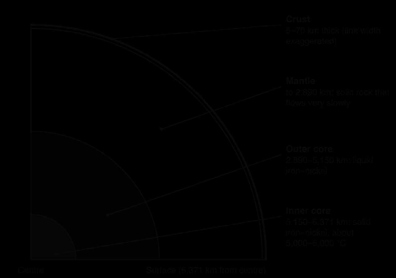
The Earth, with a radius of about 6,371 km, is made of layers that differ in composition, temperature and behaviour. Knowledge of the interior comes mostly from seismic waves; the deepest boreholes reach only about 12 km.
The inner core is a solid ball of iron and nickel about 1,220 km in radius, at roughly 5,000–6,000 °C; it stays solid because the pressure is so great. The outer core is liquid iron and nickel, and its movement generates the Earth’s magnetic field. The mantle, about 2,890 km thick, is hot silicate rock that is solid but flows very slowly, a few centimetres a year.
Characteristic | Oceanic crust | Continental crust |
|---|---|---|
Main rock | Basalt (rich in iron and magnesium) | Granite and related rocks (rich in silica) |
Thickness | About 5–10 km | About 25–70 km |
Density | About 3.0 g cm⁻³ | About 2.7 g cm⁻³ |
Age | Less than about 200 million years | Up to about 4 billion years |
At a convergent boundary | Can sink (subduct) into the mantle | Too buoyant to subduct; crumples instead |
Oceanic crust is young because it is recycled: it forms at mid-ocean ridges and sinks back into the mantle at ocean trenches. Continental crust is thicker and lighter, floats higher on the mantle and resists being pulled down, so it survives for billions of years.
For plate movement, how the outer layers behave matters more than what they are made of. The lithosphere is the rigid outer shell, made of the crust and the cooler uppermost mantle, on average about 100 km thick, and broken into tectonic plates.
Beneath it, the asthenosphere is a hotter, weaker layer of the upper mantle, a few hundred kilometres thick, in which a small fraction of the rock is molten. It deforms easily, so the rigid plates can move over it.
The idea that the continents move goes back to Alfred Wegener’s theory of continental drift (1912), based on the matching shapes of coastlines and the same fossils and rock types on continents now oceans apart. It was accepted only in the 1960s, when surveys of the ocean floor found stripes of rock magnetised in alternating directions, arranged symmetrically on either side of the mid-ocean ridges. Because the Earth’s magnetic field reverses from time to time, the stripes show that new crust forms at the ridges and moves away from them (sea-floor spreading). Plate tectonics now combines both ideas: the lithosphere is divided into plates that move relative to one another.
Plates move because the Earth is losing heat from its interior. That heat drives the slow flow of the mantle, and gravity acting on the plates provides most of the force that moves them.
About 47 terawatts of heat flow from the Earth’s interior to the surface. About half comes from the radioactive decay of uranium, thorium and potassium isotopes in the mantle and crust; the rest is primordial heat left from the planet’s formation about 4.6 billion years ago. Heat moves outward by conduction and, much more effectively, by convection.
A convection current forms when part of a fluid is heated from below: it expands, becomes less dense and rises, then spreads, cools and sinks again. Over geological time the solid mantle behaves like an extremely viscous fluid, so it convects. Older explanations pictured convection cells carrying the plates like a conveyor belt.
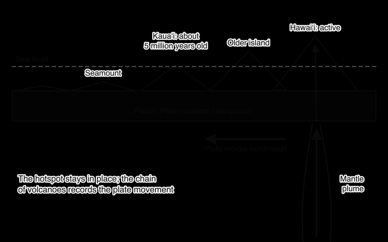
A mantle plume is a narrow column of unusually hot rock rising from deep in the mantle. Near the surface the fall in pressure makes it melt, feeding a hotspot, which can lie in the middle of a plate (Hawaii, Yellowstone) or beneath a ridge (Iceland).
Because the plume stays roughly fixed while the plate moves, a hotspot builds a chain of volcanoes that get older in the direction of plate movement. In the Hawaiian–Emperor chain, Hawaiʻi is active today, Kauaʻi is about 5.1 million years old and the eroded Emperor Seamounts reach about 81 million years; a bend in the chain records a change in the Pacific Plate’s direction about 47–50 million years ago.
The fastest plates are those with long subducting edges, which suggests that the sinking edge pulls the rest of the plate. Most geologists now see slab pull as the largest single force: cold, dense oceanic lithosphere sinks and drags the plate behind it, like a tablecloth sliding off a table.
Ridge push is a smaller force. New lithosphere at a mid-ocean ridge is hot and stands 2–3 km above the surrounding ocean floor; as it moves away it cools and sinks lower, so gravity makes the plate slide down the slope away from the ridge.
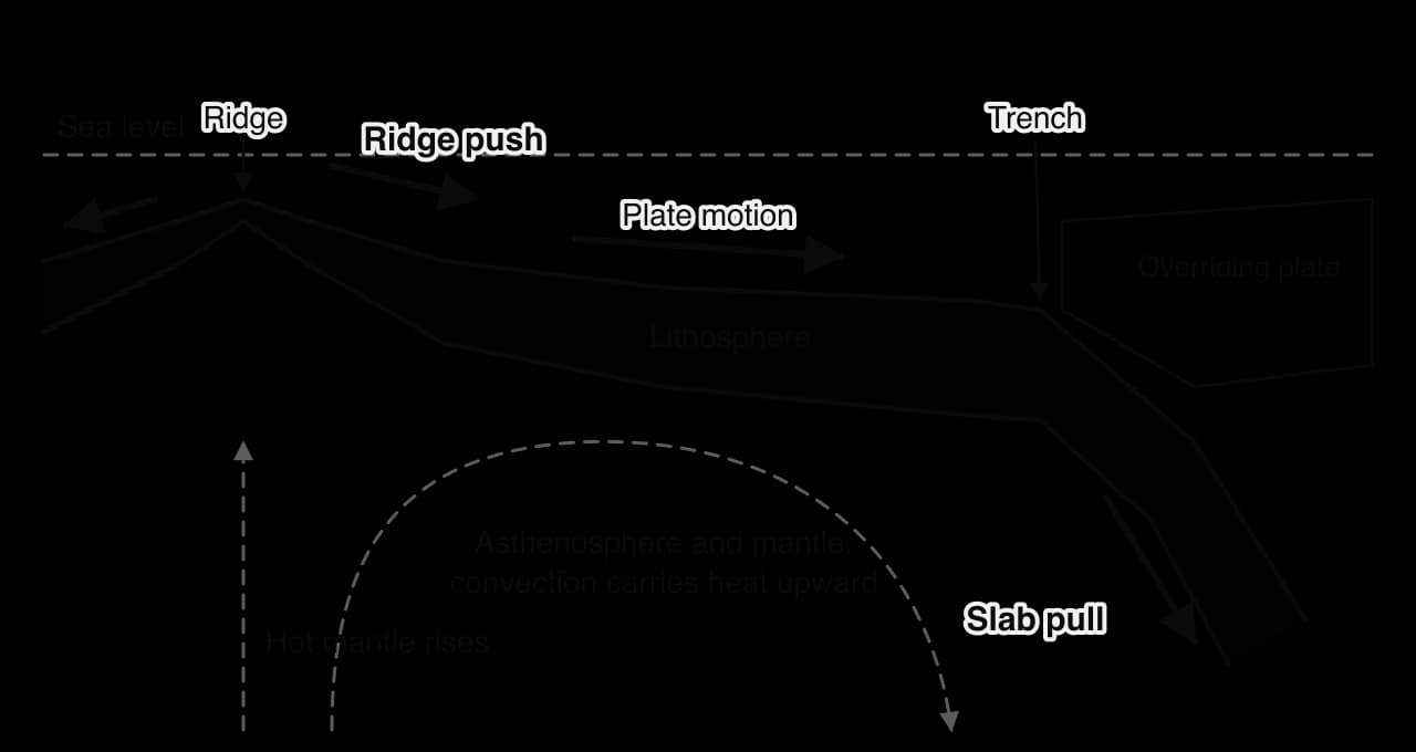
In the current view, sinking slabs and spreading ridges are themselves part of mantle convection: cold slabs are its downward limbs and plumes some of its upward limbs.
A plate boundary, also called a plate margin, is the zone where two plates meet. Stress is released at plate edges, so most earthquakes, volcanoes and young mountains are found there. Boundaries are classified by relative movement: apart, together or past each other (constructive, destructive and conservative margins in older books).
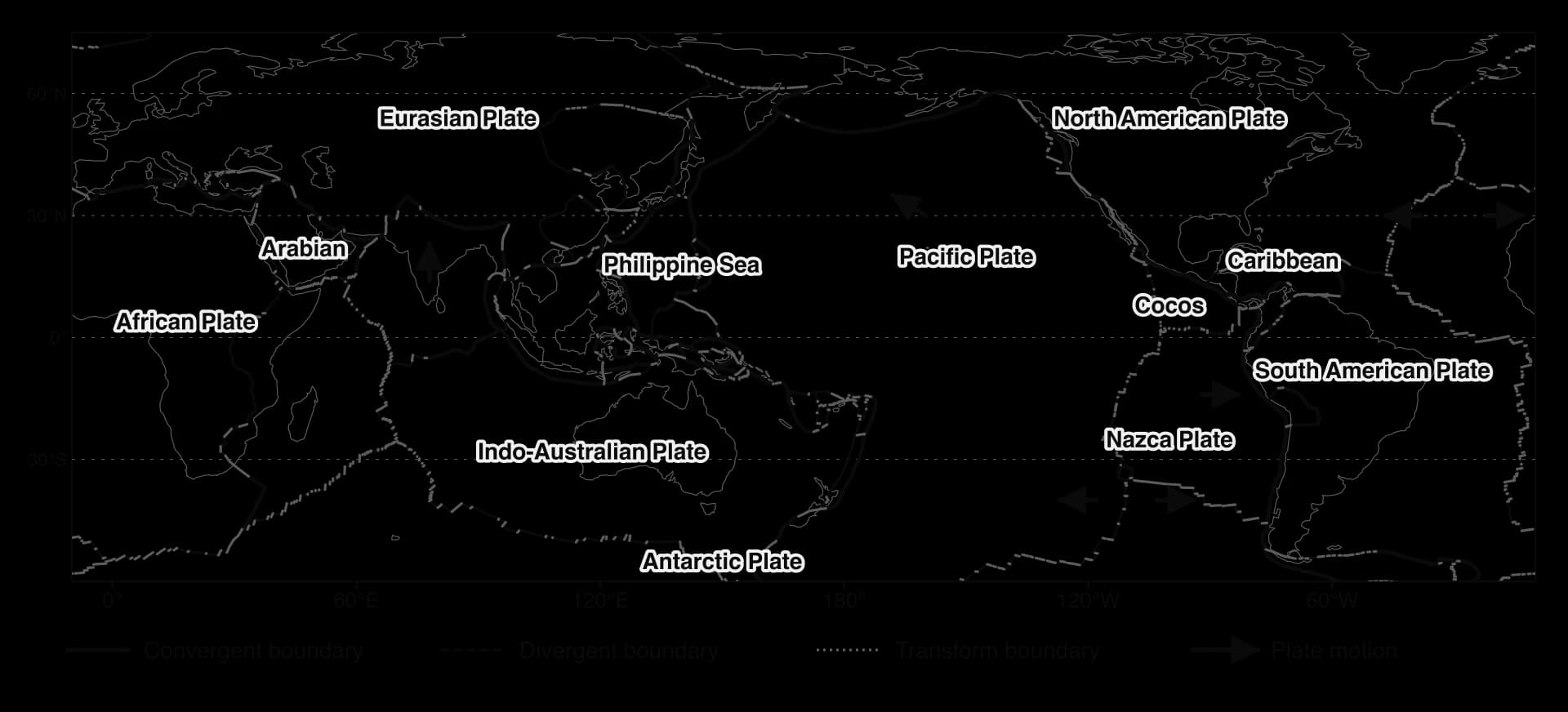
At a divergent boundary two plates move apart. The pressure on the hot mantle beneath falls, so some of it melts (decompression melting), and the magma rises to form new crust. Most divergent boundaries are mid-ocean ridges, but some begin on land as continental rifts.
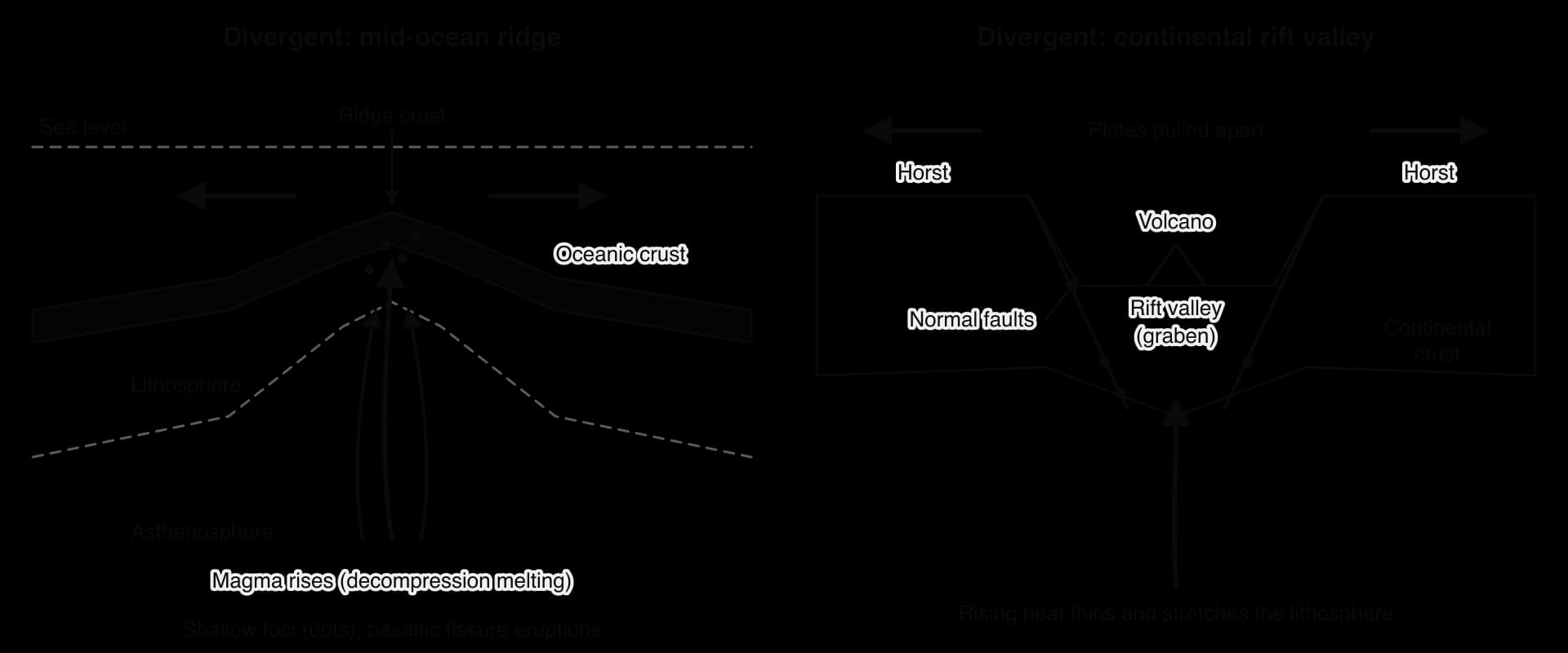
Rifting splits a continent in stages, each visible somewhere today:
Stretching. Heat rising beneath a continent, often from a mantle plume, makes the lithosphere bulge, stretch and thin.
Faulting. Parallel normal faults form and the block between them drops to form a rift valley (graben) between higher horsts, as in the East African Rift.
Volcanism. Magma rises through the thinned crust, building volcanoes on the rift floor such as Nyiragongo in the Democratic Republic of the Congo.
Flooding by the sea. The rift floor sinks below sea level and the sea floods in, as in the Red Sea, which meets the East African Rift at the Afar triple junction in Ethiopia.
Sea-floor spreading. A mid-ocean ridge then produces new oceanic crust; the Atlantic opened in this way as Pangaea broke apart, between about 200 and 160 million years ago.
In the PB2002 plate model, the Mid-Atlantic Ridge opens at about 2 cm a year near Iceland and 3.3 cm a year in the South Atlantic, and the East Pacific Rise at up to about 15 cm a year. In Iceland the ridge comes ashore, and the Reykjanes Peninsula has had repeated fissure eruptions since 2021.
At a convergent boundary two plates move towards each other and crust is destroyed or crumpled. What happens depends on the crust on each plate: oceanic–continental, oceanic–oceanic or continental–continental (a collision).
Subduction happens wherever oceanic lithosphere meets a less dense plate:
The denser plate sinks at an ocean trench; the Mariana Trench reaches about 11 km below sea level.
Stress builds where the plates lock, and is released in earthquakes, including megathrust earthquakes; as the slab sinks at an angle, foci deepen away from the trench, forming the Benioff zone.
Water lowers the melting point. At about 100 km depth, water driven out of the slab rises into the hot mantle wedge above and lowers its melting point, so part of the wedge melts while the slab itself stays largely solid.
Magma rises and, passing through continental crust, becomes richer in silica, producing viscous, gas-rich andesitic magma and explosive eruptions. The volcanoes form a volcanic arc on land (the Andes) or an island arc in the ocean (Japan, the Marianas, Tonga).
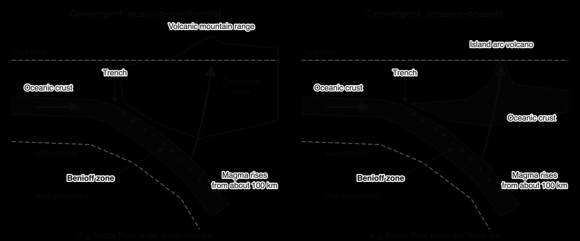
Off South America, the Nazca Plate is subducted beneath the South American Plate at about 8 cm a year, building the Andes. At the Tonga Trench, the Pacific Plate converges with the small Tonga Plate at 15–20 cm a year, the fastest convergence on Earth in the PB2002 model.
The Benioff zone can be mapped from real data. The figure plots every earthquake of magnitude 4.5 or more recorded beneath southern Tonga by the United States Geological Survey (USGS) from 1980 to 2024.
When two plates carrying continental crust meet, neither subducts far, so the crust is folded and thrust up into mountains. The Himalayas formed after India collided with Eurasia about 50 million years ago, and India still moves north at about 4–5 cm a year. There are few volcanoes, because no slab sinks deep enough to release water, but frequent shallow thrust earthquakes, such as the magnitude 7.8 Gorkha earthquake in Nepal in 2015.
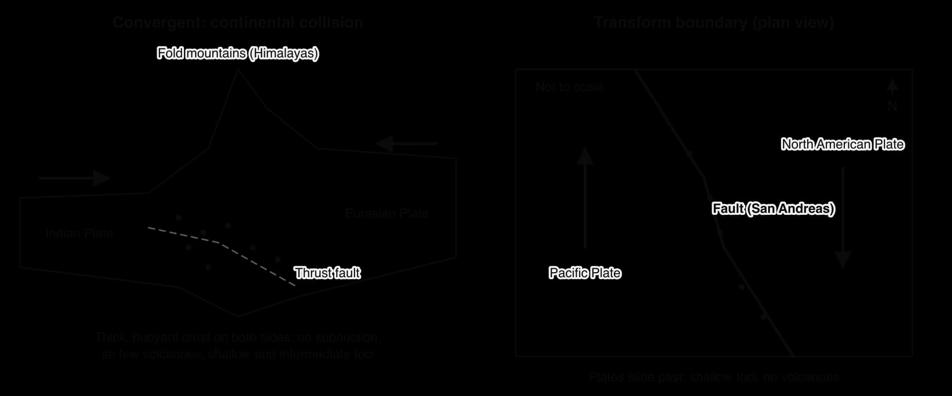
At a transform boundary two plates slide horizontally past each other along a fault, so crust is neither created nor destroyed. Friction locks the fault until strain is released in sudden, shallow earthquakes; there are no volcanoes. The San Andreas Fault in California moves at about 4.5 cm a year; the North Anatolian Fault, 1,200–1,500 km long across northern Türkiye (Turkey), slips at about 1.6–2.5 cm a year.
Boundary | Process | Landforms | Earthquakes | Volcanoes | Example |
|---|---|---|---|---|---|
Divergent (oceanic) | Plates move apart; sea-floor spreading | Mid-ocean ridge | Shallow, mostly small | Basaltic, effusive | Mid-Atlantic Ridge; Iceland |
Divergent (continental) | Rifting | Rift valley, horsts | Shallow, small to moderate | Basaltic shield and fissure | East African Rift |
Oceanic–continental | Subduction under a continent | Trench, fold mountains, volcanic arc | Shallow to deep; largest megathrusts | Andesitic composite; explosive | Nazca Plate under South America |
Oceanic–oceanic | Subduction of older oceanic plate | Trench, island arc | Shallow to deep; very large | Island arc composite; explosive | Japan; Tonga |
Collision | Continental crust thickens | Fold mountains, plateaus | Shallow and intermediate; large | Few or none | Himalayas |
Transform | Plates slide past | Fault line, offset rivers | Shallow; up to about magnitude 8 | None | San Andreas Fault |
Hotspot | Plume under a moving plate | Chain of volcanoes | Small | Basaltic shield | Hawaii |
Sources: Plate speeds from the PB2002 plate boundary model (Bird, 2003, Geochemistry, Geophysics, Geosystems); USGS; North Anatolian Fault slip rates from GPS studies (GEM Global Active Faults, 2024).
A volcano is an opening in the crust through which magma, gas and rock fragments reach the surface. About 1,600 volcanoes have erupted in the last 10,000 years, some effusively, some explosively, depending mainly on the type of magma and so on the plate setting.
Magma is molten rock containing dissolved gases, mainly water vapour, carbon dioxide (CO₂) and sulfur dioxide (SO₂). Its behaviour depends above all on its viscosity, which is controlled by silica content and temperature: silica molecules link into chains, so silica-rich magma is thick and sticky, and cooler magma is more viscous still.
Magma type | Silica | Temperature | Viscosity and gas | Typical eruption | Where it forms |
|---|---|---|---|---|---|
Basaltic | About 50% | About 1,100–1,200 °C | Low; gas escapes easily | Effusive lava fountains and flows | Divergent boundaries, oceanic hotspots |
Andesitic | About 60% | About 800–1,000 °C | Viscous; gas trapped | Explosive: ash, pyroclastic flows | Subduction zones |
Rhyolitic | About 70% or more | About 650–800 °C | Very viscous; much gas | Very explosive Plinian eruptions, calderas | Continental hotspots (Yellowstone) |
Gas is the key to explosivity. In runny basaltic magma, gas bubbles escape gently near the surface, so the eruption is an effusive eruption of lava.
In viscous magma the bubbles cannot escape. As the magma rises and the pressure on it falls, the gas expands until the magma shatters into fragments in an explosive eruption, like a shaken bottle of fizzy drink when it is opened. Water makes any eruption more explosive: magma meeting seawater or ice flashes it to steam, which expands about 1,700 times, as in the submarine Hunga Tonga eruption.
Eruption styles run from gentle to violent: Hawaiian and Icelandic fissure eruptions of basaltic lava, as at Kīlauea in 2018; Strombolian bursts of cinders; short Vulcanian explosions; and sustained Plinian eruptions with columns tens of kilometres high, as at Pinatubo in 1991.
The Volcanic Explosivity Index (VEI) rates eruptions from 0 to 8, mainly from the volume of material ejected and the height of the column. From VEI 2 upwards each step means about ten times more material, so the scale is logarithmic. An eruption of VEI 4 or more happens roughly every 18 months, VEI 6 every 50–100 years.
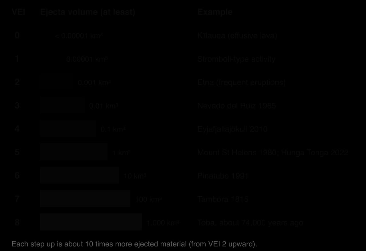
The VEI measures size, not impact. It treats ash, pumice and lava alike, gives every effusive eruption 0 or 1, and ignores the gases that affect climate. A small eruption can still be deadly: the VEI 3 eruption of Nevado del Ruiz in 1985 killed about 23,000 people.
A shield volcano is built from thousands of thin flows of runny basaltic lava that travel far before they solidify, so it is very broad with gentle slopes. Mauna Loa on Hawaiʻi, Earth’s largest active volcano, rises 4,170 m above sea level and about 9,170 m from the ocean floor, spans up to 120 km and has slopes of no more than about 12°. Shield eruptions rarely kill but destroy property: Kīlauea’s 2018 eruption destroyed about 700 houses.
A composite volcano, or stratovolcano, is a steep cone of alternating layers of ash, tephra and short, thick lava flows from viscous andesitic magma. Composite volcanoes line the subduction zones of the Pacific Ring of Fire: Mount Fuji in Japan (3,776 m), Merapi in Indonesia, Volcán de Fuego in Guatemala. Their eruptions can be sudden and explosive, and they cause most volcanic deaths.
A cinder cone is a small, steep cone of loose cinders thrown out by Strombolian bursts from a single vent, usually in one eruption. Parícutin in Mexico appeared in a cornfield in 1943 and grew to 424 m by 1952, burying two towns; three people were killed.
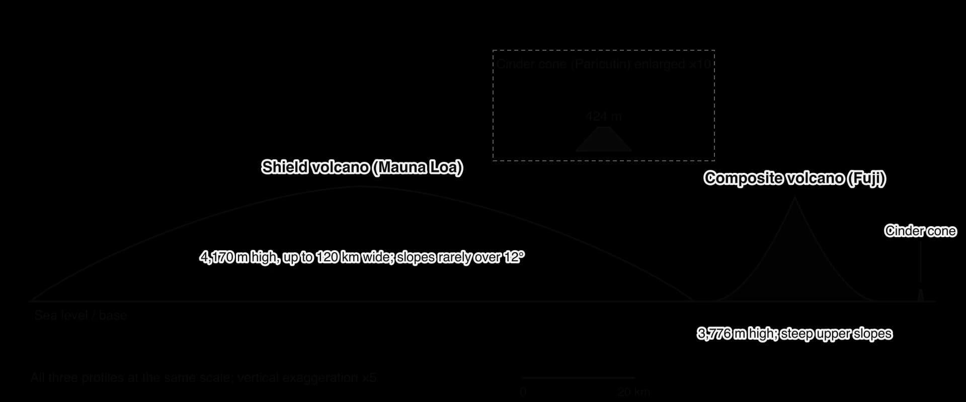
A caldera is a large crater formed when a summit collapses into an emptied magma chamber; a fissure volcano erupts from a long crack, as on Iceland’s Reykjanes Peninsula.

A primary hazard comes directly from an eruption; a secondary hazard is triggered by the eruption or its products, sometimes days or years later and far from the volcano.
Primary volcanic hazards include lava flows, which usually move slowly enough for people to escape; tephra and ash fall, which collapse roofs, ruin crops and stop aircraft engines (most of the 847 deaths at Pinatubo in 1991 were caused by roofs collapsing under wet ash); and gases. Pinatubo’s 17–20 million tonnes of SO₂ cooled the global average temperature by about 0.5 °C between 1991 and 1993.
The secondary hazards that travel furthest and kill most people are pyroclastic flows, lahars and landslides. (A pyroclastic flow comes from the eruption itself, so some books class it as primary.)
A pyroclastic flow forms when an eruption column or lava dome collapses. The mixture of hot gas, ash and rock is denser than air, so it rushes downhill along valleys, often faster than 100 km per hour and at several hundred degrees Celsius; nobody in its path can outrun it. Pyroclastic flows from the Soufrière Hills volcano destroyed Plymouth, the capital of Montserrat, in the late 1990s, and in June 2018 pyroclastic flows from Volcán de Fuego in Guatemala swept down the Las Lajas ravine into villages such as San Miguel Los Lotes, killing at least 190 people.
A lahar forms when water from heavy rain, melted snow and ice or a crater lake mixes with loose volcanic debris. With the consistency of wet concrete, lahars follow river valleys for tens of kilometres. In 1985 a small eruption of Nevado del Ruiz in Colombia melted part of its glaciers; four lahars travelling at about 50 km per hour buried the town of Armero, killing more than 20,000 of its almost 29,000 people. Hazard maps existed but were poorly distributed.
A flank collapse happens when the side of a volcano, weakened by rising magma or heavy rain, slides away as a debris avalanche. In 1980 the north face of Mount St Helens collapsed in the largest landslide on land in recorded history; about 57 people died. In December 2018 part of Anak Krakatau in Indonesia collapsed into the sea, causing a tsunami that killed 426 people with no earthquake to warn them.
Other hazards include jökulhlaups (floods when an eruption melts a glacier from below), gas bursts from lakes (CO₂ from Lake Nyos in Cameroon suffocated 1,746 people in 1986) and ash clouds: in April 2010, ash from Eyjafjallajökull led about 20 countries to close their airspace, affecting about 10 million travellers.
An earthquake is a sudden shaking of the ground caused by the release of energy stored in rocks. About 1,800 earthquakes of magnitude 5 or more are recorded worldwide each year, almost all at plate boundaries, and their depth, size and waves depend on the plate movement that causes them.
Most earthquakes occur on a fault, a fracture along which the rocks on either side have moved. The elastic rebound theory, developed after the 1906 San Francisco earthquake, explains them: friction locks the fault while the plates keep moving, so the rocks bend and store energy until the fault slips suddenly and they spring back, releasing the energy as seismic waves.
Foreshocks sometimes precede the main shock, and aftershocks follow for weeks or years: after the Gorkha earthquake in Nepal in 2015, more than 450 aftershocks of magnitude 4 or more were recorded within a year.
The focus (hypocentre) is the point underground where the rupture begins; the epicentre is the point on the surface directly above it; the distance between them is the depth of focus. Earthquakes are shallow (0–70 km), intermediate (70–300 km) or deep (300–700 km). Deep earthquakes occur only in subducting slabs, the only place where cold, brittle rock reaches such depths.

Shallow earthquakes do much more damage than deep ones of the same magnitude, because seismic waves lose energy as they travel: waves from a focus 600 km down are much weakened at the surface, while waves from 10 km arrive almost at full strength.
Energy from the focus travels as body waves through the Earth and surface waves along it.
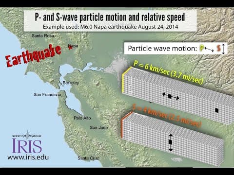
P waves arrive first, at about 6 km per second in the crust, and are felt as a sharp jolt.
S waves follow with stronger sideways shaking. Because S waves cannot pass through liquids, they are not detected on the far side of the Earth from a large earthquake (the S-wave shadow zone): the first evidence that the outer core is liquid.
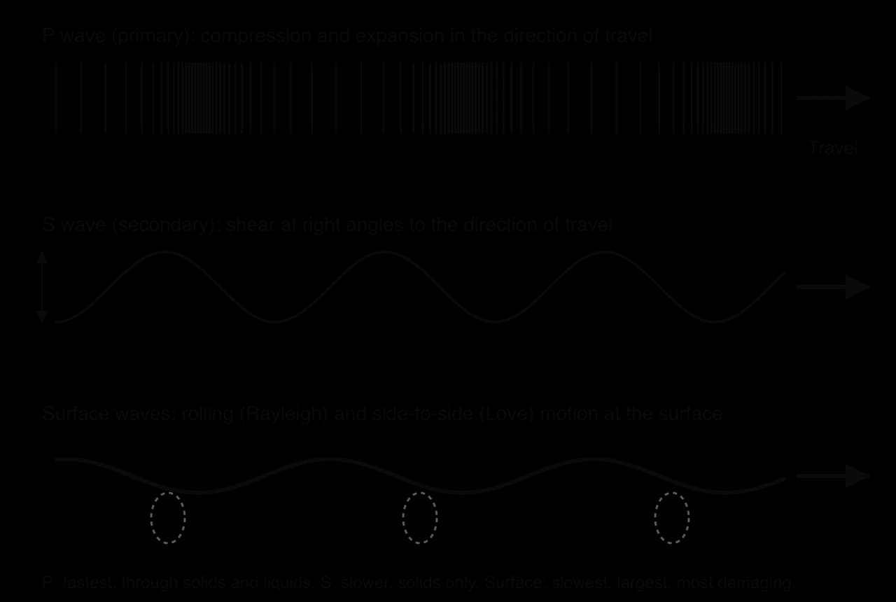
Surface waves arrive last but with the largest motion, and most damage happens while they pass.
 YouTube
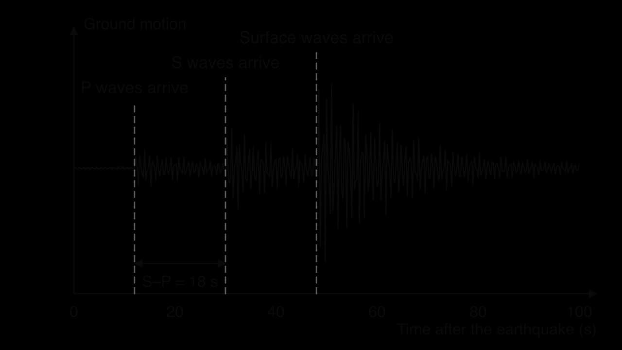
The S–P interval increases with distance because the two waves travel at different speeds. The same difference is used by earthquake early warning systems, which detect P waves near the epicentre and send alerts before the damaging waves arrive further away.
The moment magnitude scale (Mw) measures the energy released at the source and is used for all large earthquakes today. The older Richter scale (1935) underestimates the largest earthquakes and is no longer used for them. The scale is logarithmic, so a small difference in magnitude is a large difference in energy.
The Modified Mercalli Intensity scale (MMI) rates the shaking at a place from I (not felt) to XII (total destruction), from what people feel and the damage caused: at VII poorly built buildings are damaged, at IX well-designed buildings are badly damaged.
Earthquake size depends mainly on the area of fault that ruptures. At subduction zones the dipping fault between the plates can be hundreds of kilometres long and wide, so every recorded earthquake above magnitude 9 has been a megathrust earthquake: Valdivia, Chile (1960, Mw 9.5, the largest recorded), Sumatra (2004, Mw 9.1) and Tōhoku, Japan (2011, Mw 9.1).
Transform faults are narrow and vertical, so their shallow strike-slip earthquakes rarely exceed magnitude 8, but on land they are destructive: the Mw 7.8 Kahramanmaraş earthquake in Türkiye on 6 February 2023 ruptured about 370 km of the East Anatolian Fault, with up to about 12 m of sideways slip. Divergent boundaries have small, shallow earthquakes; collision zones large, shallow thrust earthquakes such as Wenchuan, China (2008, Mw 7.9). A few intraplate earthquakes occur far from boundaries on old zones of weakness.
Human activity can trigger earthquakes by changing the stress or water pressure on faults that are already close to failure.
Reservoirs. The largest accepted case of reservoir-induced seismicity is the 1967 Koynanagar earthquake in India (Mw 6.6), centred near the Koyna Dam reservoir, which killed about 180 people. Whether the Zipingpu reservoir, a few hundred metres from the fault, helped trigger the 2008 Wenchuan earthquake is still debated.
Wastewater injection. In Oklahoma, USA, where waste water from oil and gas wells is pumped deep underground, earthquakes of magnitude 3 or more rose from one or two a year before 2009 to one or two a day; after a magnitude 5.8 earthquake near Pawnee in 2016, nearby wells were shut.
Gas extraction. At Groningen in the Netherlands, induced earthquakes have damaged homes since 1991; after a magnitude 3.6 earthquake in 2012, production was cut and stopped in October 2023.
Fracking and geothermal energy. Fracking near Blackpool, UK, triggered a magnitude 2.3 earthquake in 2011, and England halted fracking in November 2019 after further tremors. In Pohang, South Korea, a government commission concluded that fluid injected for a geothermal project triggered the Mw 5.5 earthquake of 2017, which injured 82 people.
A tsunami forms when a megathrust earthquake makes the overriding plate spring up by several metres, lifting the water column above it. The waves are low in the deep ocean, with wavelengths of up to 200 km; in shallow water they slow, shorten and grow, the sea often first retreats (the drawback), and the water surges inland to a maximum height called the run-up.
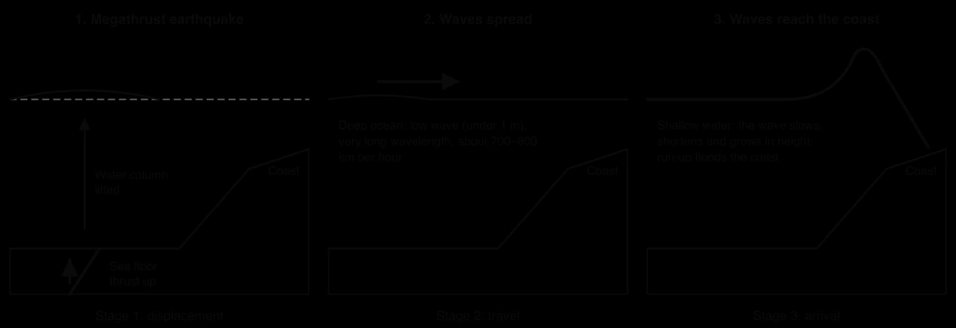
The 2004 Indian Ocean tsunami, from the Mw 9.1 Sumatra–Andaman earthquake, killed about 228,000 people; the 2011 Tōhoku tsunami reached a run-up of 40.5 m and travelled up to 10 km inland. Shaking also triggers landslides on steep slopes: the Wenchuan earthquake caused about 200,000 landslides over about 110,000 km² and more than 800 “quake lakes” where landslides dammed rivers.
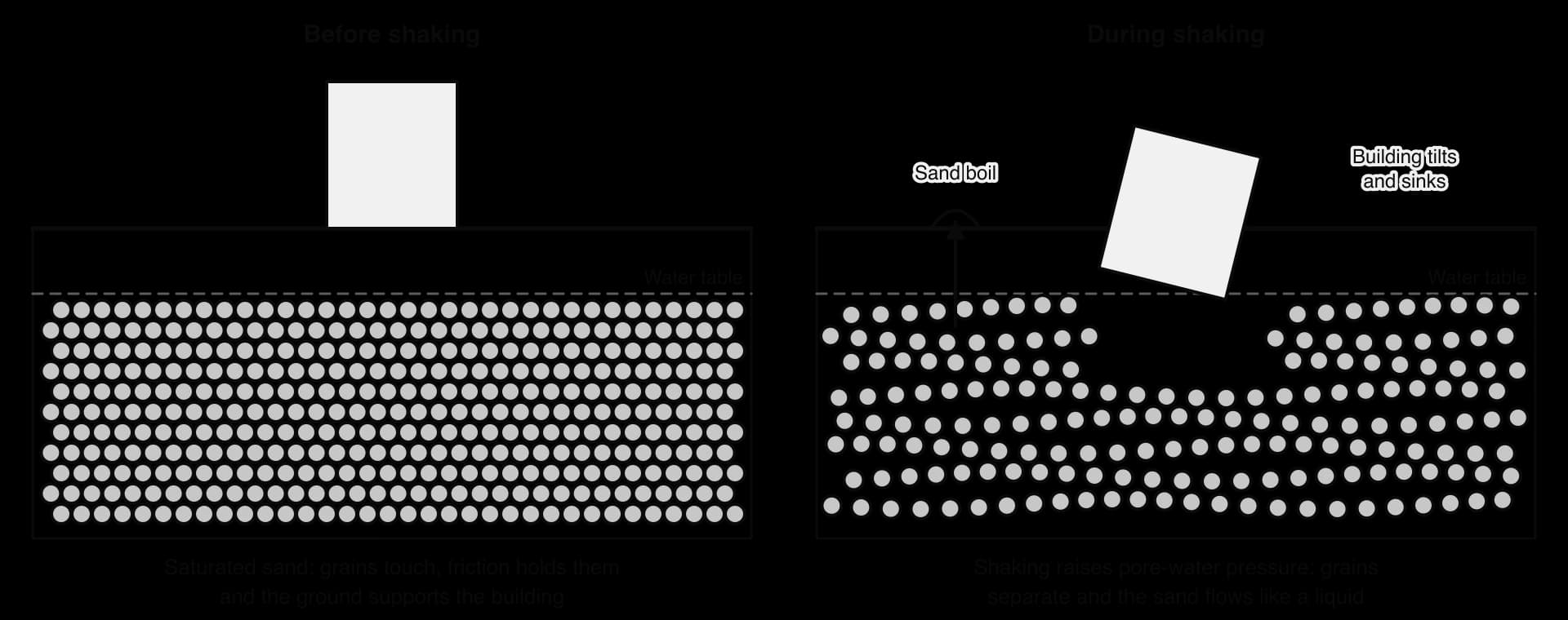
Liquefaction happens in loose, saturated sand and silt, such as river deposits and reclaimed land. Shaking raises the pressure of the water between the grains until they are pushed apart and the ground flows like a liquid, so buildings tilt and sink. In the Mw 6.2 Christchurch earthquake of 22 February 2011, which killed 185 people, liquefaction brought about 400,000 tonnes of silt to the surface in the eastern suburbs.
In shallow earthquakes the fault can break the surface, offsetting the ground by metres. This surface rupture cuts roads, pipes and buildings, and in large earthquakes it can jump onto secondary faults that branch from or cross the main fault: the 2016 Kaikōura earthquake in New Zealand (Mw 7.8) ruptured about 25 faults in one sequence, a world record.
Mass movement, sometimes called mass wasting, ranges from the creep of soil, visible only over years, to rockfalls and debris flows that arrive in seconds. Mass movements happen on slopes everywhere, but the largest and deadliest cluster in steep, wet and tectonically active mountains.
Whether a slope moves depends on a balance of forces. Shear stress, the force acting downslope, comes mostly from the part of the material’s weight that acts parallel to the slope. It increases when the slope is steepened (by a river, the sea or a road cutting), loaded (by buildings, waste or water) or shaken.
Shear strength, the resistance of the material, comes from friction between grains, cohesion (the “stickiness” of clay or cement between particles) and plant roots. It falls when rock weathers, vegetation is removed or water fills the pores.
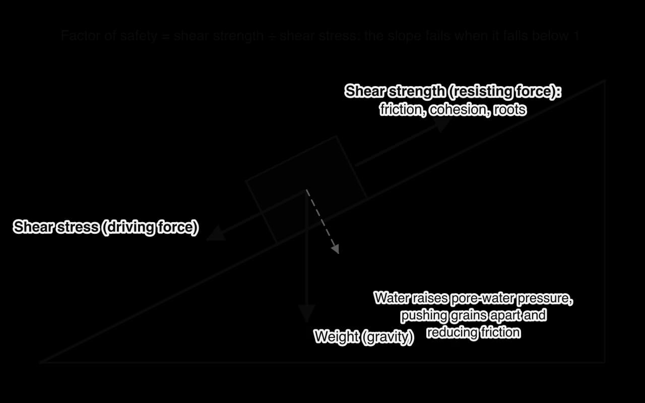
A slope is stable while this factor of safety is above 1 and fails when it falls below 1. Water is the commonest trigger because it acts on both sides: it adds weight, raising shear stress, and it raises the pore-water pressure between particles, pushing them apart and reducing friction. Most landslides therefore happen during or after heavy or prolonged rain.
Mass movements are classified by how the material moves, following the scheme of the geologist David Varnes. Landslide is the everyday umbrella term for most rapid types.
Falls: rock drops from a steep face, often after freeze-thaw weathering, and collects as scree; topples tip forward.
Slides move as a coherent mass along a slip surface: flat in a translational slide (a bedding plane, joint or clay layer), curved in a rotational slide (slump), so the block tilts backwards, common in clay and on undercut cliffs.
Flows move like a fluid: a debris flow is a fast, saturated mixture of mud, rock and vegetation; a mudflow is a flow of finer material; earthflows are slower. Lahars are volcanic debris flows, and rock and snow avalanches are very rapid flows of broken rock or snow down steep mountain slopes.
Creep: soil creep moves millimetres a year as particles are lifted at right angles to the slope by wetting or freezing and settle slightly downslope, tilting trees, posts and walls and forming terracettes, small step-like ridges along grassy slopes. In cold environments, solifluction is faster flow of thawed soil over frozen ground.
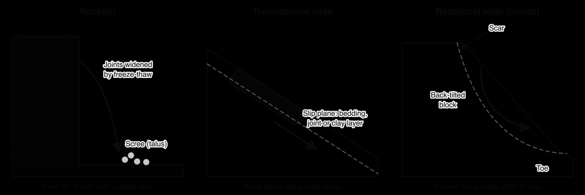
Slides keep much of their internal structure, so trees and buildings may ride on the moving block. In flows the material is broken up and mixed with water, so it spreads out where the slope flattens.
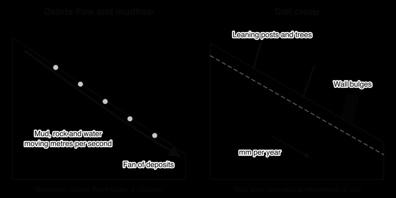
Creep and slumps damage property but rarely kill; rapid flows and falls cause most landslide deaths.
Criterion | Range | Example |
|---|---|---|
Cause: physical | Heavy rain, snowmelt, earthquakes, eruptions, undercutting by rivers and waves, weathering, wildfire | Wenchuan earthquake, 2008: about 200,000 landslides |
Cause: human | Slope cutting, loading with buildings or waste, deforestation, leaking pipes, quarrying, reservoirs | Aberfan, Wales, 1966; Shenzhen, China, 2015 |
Liquidity | Dry (falls, slides) → saturated (flows) | Rockfall; debris flow |
Speed of onset | Under 16 mm a year → over 5 m per second (Varnes velocity scale) | Soil creep; Armero lahar, 1985 |
Duration | Seconds → decades | Mount St Helens collapse, 1980; creep |
Extent | One boulder → a whole valley | Wenchuan landslides over about 110,000 km² |
Frequency | Every monsoon → once in centuries | Himalayan monsoon landslides; flank collapses |
Liquidity is closely linked to speed: on slopes, more water usually means faster and longer travel, although dry rockfalls are fast because the rock falls freely. The speed of onset decides whether people can escape.
Overloaded, wet slopes can fail fast. In 1966 a colliery spoil tip above Aberfan in Wales, built over a spring, became saturated and slid down as a slurry, killing 144 people, 116 of them children at the village school; in 2015 a 20-storey pile of construction waste in Shenzhen, China, buried 33 buildings, killing 73.
Carson and Kirkby (1972) placed mass movements in a triangle whose corners are slide or fall (fast, dry), heave (slow movements such as creep) and flow (wet). Each movement plots according to its speed and water content, so the diagram shows how types grade into one another.
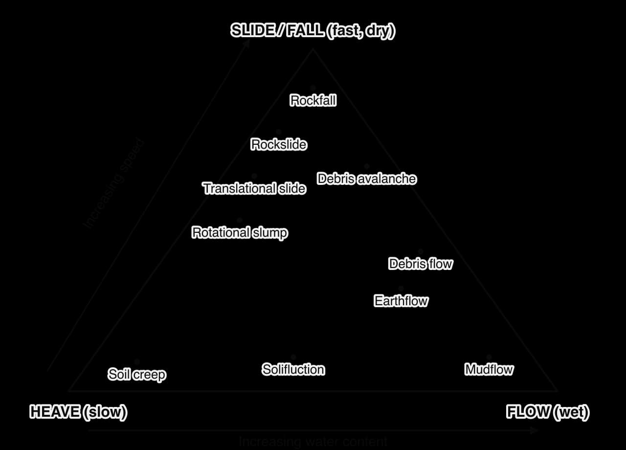
Classifications help geographers compare events and choose protection: a rockfall needs netting or a barrier, a slow deep slide needs drainage, a debris flow needs a channel or warning. But events change type (a slide becomes a flow), the criteria overlap, and causes are usually multiple, a preparatory cause such as deforestation plus a trigger such as a storm, so labelling an event “human” or “physical” can be a judgement about blame.
The Carson and Kirkby triangle shows overlaps better than a list of types, but it uses only speed and water content and ignores cause, extent and frequency, which matter most for the risk to people. A useful classification combines a movement type with all six criteria.
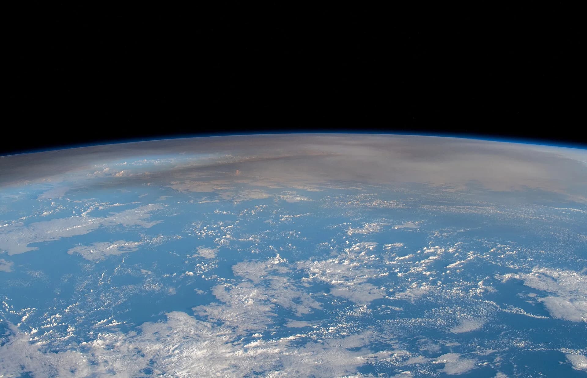
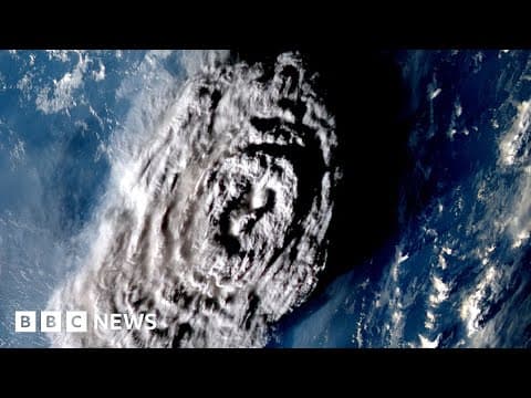
On 15 January 2022 a submarine volcano in Tonga produced the largest atmospheric explosion recorded by modern instruments. The eruption shows subduction, explosive interaction between magma and seawater and a cascade of secondary hazards in a single event.
Hunga Tonga–Hunga Haʻapai lies about 65 km north of Tongatapu, Tonga’s main island, on the Tonga–Kermadec island arc. East of the arc the Pacific Plate is subducted at the Tonga Trench at 15–20 cm a year. Before 2022 the volcano was a submarine caldera whose rim showed above the sea as two small uninhabited islands, joined by an eruption in 2014–2015.
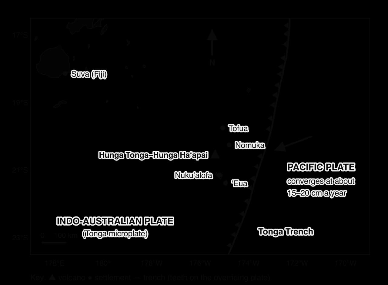
Activity resumed on 20 December 2021 with steam-driven explosions. The climactic eruption began at 17:14 local time on 15 January and lasted about 12 hours, with a column about 57–58 km high, the highest measured by satellite.
Two processes combined. The magma was a viscous, gas-rich basaltic andesite, typical of a subduction zone; and the vent lay under the sea, so as the chamber emptied and its roof collapsed, seawater poured in, flashed to steam and shattered the magma in a series of blasts. A new caldera about 4 km wide formed, its floor about 850 m below sea level.
Measure | Value |
|---|---|
Eruption column | About 57–58 km high |
Volcanic Explosivity Index | VEI 5 (Smithsonian); other estimates up to about 6 |
Material displaced | About 10 km³ of rock, ash and sediment |
Water vapour into the stratosphere | About 146 million tonnes (about 10% of its usual water) |
Sulfur dioxide | About 400,000 tonnes: too little to cool the climate |
Deaths | At least 4 in Tonga; 2 in Peru |
Damage in Tonga | US$90.4 million, about 18.5% of GDP |
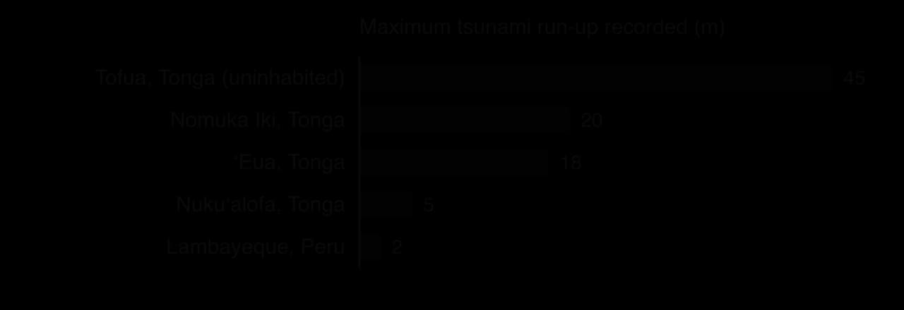
Tsunami. The explosions, the caldera collapse and the pressure wave displaced seawater across the Pacific. Run-ups reached 3–5 m in Nukuʻalofa, 18 m on ʻEua, over 20 m on Nomuka Iki and 45 m on uninhabited Tofua. In Japan 229,000 residents were evacuated, and two people drowned in Peru, about 10,000 km away.
Atmospheric pressure wave. A pressure wave circled the Earth several times at close to the speed of sound, raising pressure by up to about 7 hPa in New Zealand.
Ash fall contaminated rainwater supplies collected from roofs, damaged crops and closed the airport.
A submarine flow. Tonga’s undersea cable was broken in several places, with sections carried 5 km and buried under silt, the signature of a fast turbidity current of sediment collapsing from the volcano.
The death toll was low for so large an eruption: at least four people died in Tonga, including residents of Mango and Nomuka. All structures on Mango, home to 36 people, were destroyed. The World Bank estimated that about 85,000 people, around 85% of the population, were affected, and put the damage at US$90.4 million, about 18.5% of GDP, mostly to buildings, agriculture and infrastructure.
Isolation deepened the impacts. With the cable cut, Tonga lost most international communications for five weeks, until 22 February. Ash on the airport delayed the first relief flights from New Zealand and Australia until 20 January, and although aid was delivered without contact where possible, COVID-19 reached the country and Tonga entered lockdown on 2 February.
Sources: World Bank press release, 14 February 2022; Smithsonian Global Volcanism Program; NIWA, 2022; Japan Fire and Disaster Management Agency; Wikipedia, “2022 Hunga Tonga–Hunga Haʻapai eruption and tsunami” (accessed 2026).
Concept | How the eruption shows it |
|---|---|
Process | Subduction produced viscous magma; seawater made the eruption extreme; collapse, pressure waves and turbidity currents created cascading hazards. |
Place | A submarine vent near low islands made tsunami and ash, not lava, the main threats; a small island state with one cable was easily cut off. |
Scale | Local destruction on Mango, a national loss of 18.5% of GDP, and global effects through the pressure wave, a Pacific-wide tsunami and stratospheric water vapour. |
Analysis questions
Explain how Tonga’s plate boundary setting made an explosive eruption likely.
Using the run-up chart, describe the pattern of tsunami run-up and suggest two reasons for it.
To what extent was Tonga’s isolation, rather than the size of the eruption, responsible for its impacts on people?
 YouTube
Questions on geophysical systems appear in Paper 1: a structured question on a stimulus worth 10 marks and a choice of two 10-mark extended responses. They usually ask you to read plate or hazard data, explain a process, or examine how processes produce different types and sizes of event.
Eruption | Year | Plate setting | VEI |
|---|---|---|---|
Nevado del Ruiz, Colombia | 1985 | Subduction (Nazca Plate under South American Plate) | 3 |
Eyjafjallajökull, Iceland | 2010 | Divergent (Mid-Atlantic Ridge) with a hotspot | 4 |
Mount St Helens, USA | 1980 | Subduction (Juan de Fuca Plate under North American Plate) | 5 |
Pinatubo, Philippines | 1991 | Subduction (Eurasian Plate under the Philippine Mobile Belt at the Manila Trench) | 6 |
Hunga Tonga–Hunga Haʻapai, Tonga | 2022 | Subduction (Pacific Plate under Tonga Plate) | 5 |
Sources: VEI ratings of the Smithsonian Institution Global Volcanism Program, as listed by Wikipedia, “Volcanic explosivity index”, accessed 2026.
The Earth has a solid inner core, a liquid outer core, a slowly flowing mantle and a thin crust; the rigid lithosphere moves over the weak asthenosphere.
Internal heating drives mantle convection; slab pull is the main force moving plates, ridge push is smaller, and mantle plumes feed hotspots such as Hawaii.
Divergent boundaries have shallow earthquakes and effusive eruptions; subduction zones have Benioff zones, megathrust earthquakes and explosive composite volcanoes; collision zones have large shallow earthquakes but few volcanoes; transform faults have no volcanoes.
Silica content controls viscosity and so eruption style: shield volcanoes (basaltic), composite volcanoes (andesitic) and small cinder cones; the VEI measures eruption size on a logarithmic scale.
Pyroclastic flows, lahars and flank collapses are the deadliest volcanic hazards.
Magnitude (Mw) measures an earthquake’s energy and intensity (MMI) the shaking at a place; tsunamis, landslides, liquefaction and surface rupture are its secondary hazards, and human activity can trigger earthquakes.
Mass movements occur when shear stress exceeds shear strength, often after pore-water pressure rises, and are classified by type and by cause, liquidity, speed of onset, duration, extent and frequency.
I can describe the Earth’s layers and distinguish oceanic from continental crust and the lithosphere from the asthenosphere.
I can explain how internal heating, convection, plumes, slab pull and ridge push move plates.
I can explain subduction and rifting step by step and draw each plate boundary type.
I can explain how magma type controls eruption style and compare the three volcano types.
I can describe pyroclastic flows, lahars and flank collapse with named examples.
I can describe the characteristics of earthquakes and distinguish magnitude from intensity.
I can explain how earthquake secondary hazards develop and how human activity triggers earthquakes.
I can classify mass movements and evaluate the classifications.
I can interpret a Benioff zone cross-section and estimate plate and tsunami speeds from data.
Hotspots produce volcanoes away from plate boundaries (eg Hawaiʻi, Kīlauea 2018); intraplate earthquakes can occur on old faults (eg New Madrid, USA, 1811–1812).
Depth and type of movement influence how hazardous the events are, eg shallow-focus earthquakes cause stronger ground shaking at the surface.
Good answers may be well structured (AO4) and may additionally offer a critical evaluation (AO3) which examines the strength of the relationship, for example noting that plate boundary type explains the location of almost all earthquakes and volcanoes, but that hotspots and intraplate events show it is not complete. Another approach might be to distinguish between the distribution of hazard events and the distribution of hazard risk: many boundary zones are sparsely populated (mid-ocean ridges), while others are densely populated (Java, Japan, the Andes), so the physical relationship does not on its own explain where the hazard is greatest for people (places, processes).
For 5–6 marks, expect some weakly-evidenced outlining of the distribution of earthquakes and/or volcanoes in relation to plate boundaries.
For 7–8 marks, expect a structured account which includes:
either well-evidenced explanation of the processes at two or more types of plate boundary and the hazards they generate
or a discursive conclusion (or ongoing evaluation) grounded in geographical concepts and/or perspectives, eg on exceptions to the relationship.
For 9–10 marks, expect both of these traits.
NB. Maximum [6] if only earthquakes or only volcanoes are addressed. Well-drawn annotated diagrams of plate boundaries should be credited.
Marks | Level descriptor |
|---|---|
0 | The response does not reach a standard described by the descriptors below. |
1–2 | Too brief, lists unconnected information, not focused on the question and lacks structure. Knowledge is very general, with large gaps or errors; examples or case studies are missing or only listed. No analysis; terminology is missing or used incorrectly. |
3–4 | Too general, lacks detail, not focused on the question and largely unstructured. Outlines examples, statistics and facts, both relevant and irrelevant, with links to the question only listed. Basic terminology is used, with errors or inconsistently. No critical evaluation of evidence; any conclusion is irrelevant. |
5–6 | Partially addresses the question, with a narrow argument, an unsubstantiated conclusion and limited evaluation. Describes relevant supporting evidence (examples, case studies) and outlines links to the question. The argument repeats one point or covers only part of the question. Other perspectives, or strengths and weaknesses of evidence, are listed. |
7–8 | Addresses the whole question; the analysis is evaluated and the conclusion is relevant but lacks balance. Relevant evidence is described correctly and covers all the main points. The argument is clear but one-sided or unbalanced. Complex terminology is used correctly but not consistently. Other perspectives, or strengths and weaknesses of evidence, are described. |
9–10 | In-depth and specific to the question (topic and command term). Correct, relevant examples, statistics and detail are integrated and their link to the question explained. The argument is balanced, explaining complexity, exceptions and comparisons. Evaluation of evidence and perspectives is well developed, and the conclusion is balanced and aligned with the evidence. Logically structured and easy to follow. |
Examine why the global distribution of mass movement hazards differs from that of earthquake and volcanic hazards.
10 marks
Examine the relative importance of mantle convection and slab pull as mechanisms of plate movement.
10 marks