Explain and evaluate the management of desertification, competition for resources, new technology and climate change adaptation in cold and arid environments, using the Sahel, Fosen and other named examples.
Each is in the Geography glossary, with every other term in the subject.
Small-scale mining by individuals, families or small groups using simple tools, often informal or illegal, with little protection for workers or the environment.
Water with a much higher concentration of dissolved salts than seawater, produced as waste by desalination plants or found naturally beneath salt flats.
The idea, proposed by Jule Charney in 1975, that vegetation loss in drylands raises surface albedo and reduces rainfall, so that less vegetation grows: a positive feedback.
The planned, permanent movement of a community away from a place made unsafe or uninhabitable by the effects of climate change, such as erosion or permafrost thaw.
A technology in which mirrors focus sunlight onto a receiver to heat a fluid that drives a turbine; the heat can be stored, for example in molten salt, to generate power after dark.
Land degradation in arid, semi-arid and dry sub-humid areas resulting from various factors, including climatic variations and human activities (UNCCD definition).
A low-cost method of restoring degraded farmland in which farmers protect and prune shoots growing from the living stumps and roots of trees and shrubs so they grow into trees.
Distinguish desertification from drought and from the natural expansion of deserts.
Explain the human, conflict-related and climatic causes of desertification and the positive feedbacks that accelerate it.
Evaluate strategies for managing desertification, including farmer-managed natural regeneration, water harvesting and the Great Green Wall.
Examine the increasing competition for resources in extreme environments, including the roles of Indigenous groups, civil society organisations, TNCs and militia groups.
Evaluate the contribution of new technology, especially solar power and desalination, to sustainable development in extreme environments.
Explain the impacts of global climate change on cold and hot arid environments.
Evaluate how local populations adapt to climate change in extreme environments, and the limits to adaptation.
Extreme environments are changing faster than most other places on Earth. Drylands face land degradation and more variable rainfall, the Arctic is warming nearly four times as fast as the global average, and the resources of both are increasingly contested. Their futures depend on the choices made about land, water, energy and emissions, many of them by people who live far away.
Two key concepts frame the topic. Possibility asks which futures are achievable: whether degraded land can be restored, whether desert sunlight can power whole regions, and whether communities can adapt to warming. Power asks who decides: Indigenous herders, national governments, transnational corporations and armed groups all compete for the same land and resources, and the costs of climate change fall on people who did least to cause it.
73 exam-style questions on this subtopic, written in the style of the IB papers. The first has its markscheme open. Counted on
Examine the relationship between changes in glacier mass balance and the development of glacial landforms.
10 marks
Marks should be allocated according to the markbands.
A glacier is an open system. Its mass balance is the difference between inputs of snow and ice (accumulation, from snowfall, avalanches and wind-blown snow) and outputs (ablation, by melting, sublimation and calving). Above the equilibrium line altitude (ELA), accumulation exceeds ablation; below it, ablation dominates. A positive annual balance leads over time to thickening and advance of the snout; a negative balance leads to thinning and retreat. Changes in mass balance alter ice thickness, velocity, meltwater supply and the position of the ice margin, all of which affect landform development.
Possible applied themes (AO2) demonstrating knowledge and understanding (AO1):
Glacier flow transfers ice from the zone of accumulation to the zone of ablation; a steeper mass-balance gradient produces faster flow, which increases basal sliding and so plucking and abrasion.
Cirques form close to the regional snowline/ELA, where snow accumulates in sheltered (often north- and east-facing in the Northern Hemisphere) hollows; nivation and then rotational flow enlarge the hollow. The altitude of cirque floors in an area reflects former ELAs.
Positive mass balance and advance thicken ice, increasing erosive power and pushing debris forward to build terminal or push moraines at the furthest extent.
Periods of stable mass balance allow a snout to stay in one position, so recessional moraines build up; a series of recessional moraines records pauses in retreat.
Strongly negative mass balance increases meltwater, building outwash plains, kames and eskers; it also exposes oversteepened valley sides, leading to rockfall and debris covering the ice.
With a free account, Augment remembers where you stopped and what you have practiced.
Collecting water from fog by placing large vertical mesh nets in its path, so that droplets gather on the mesh and drip into a trough below.
The principle that Indigenous peoples may give or withhold consent to a project affecting their lands or resources, freely, before it begins and with full information about its impacts.
A sudden release of water from a lake dammed by a glacier or moraine when the dam is overtopped or breached, often after an ice or rock avalanche falls into the lake.
An African Union initiative adopted in 2007 to restore degraded land across the Sahel from Senegal to Djibouti, aiming to restore 100 million hectares by 2030.
An artificial glacier made in winter by piping and spraying stream water into cold air so that it freezes into a tall cone of ice, which melts slowly to supply water in spring.
A contract between a resource company and an Indigenous community setting out the jobs, training, payments and monitoring the community receives in return for supporting a project.
A long-term decline in the biological or economic productivity of land, caused by processes such as soil erosion, nutrient loss, salinisation and loss of vegetation.
An armed group that is not part of a state’s regular armed forces, such as a rebel or paramilitary force, which may control territory and resources by force.
A satellite-derived measure of the greenness and density of vegetation, calculated from reflected red and near-infrared light, ranging from −1 to +1, with higher values meaning more vegetation.
Farming land so intensively, for example by shortening or abandoning fallow periods, that the soil loses nutrients, organic matter and structure faster than they are replaced.
Keeping more livestock on an area of pasture than its vegetation can support, so plants are eaten faster than they regrow and the soil is left bare and compacted.
The warming and melting of ground ice in permafrost, which deepens the active layer, causes subsidence and releases stored carbon as carbon dioxide and methane.
A technology that converts sunlight directly into electricity in semiconductor cells, usually made of silicon, mounted in panels.
A desalination method in which seawater or brackish water is pumped at high pressure through a semi-permeable membrane that lets water pass but holds back dissolved salts.
Frozen seawater floating on the ocean surface; in the Arctic it grows each winter and shrinks each summer to a minimum in September.
The process by which nomadic or semi-nomadic people settle permanently in one place, often encouraged by governments through boreholes, services or restrictions on movement.
Electricity or heat generated from the energy of sunlight, either by photovoltaic panels or by concentrating sunlight to heat a fluid.
A non-binding declaration adopted by the UN General Assembly in 2007 that sets out the rights of Indigenous peoples to their lands, resources, cultures and self-determination.
The lowest temperature to which air can be cooled by evaporating water into it; it combines heat and humidity and indicates how well the human body can cool itself by sweating.
A small planting pit, typically 20–40 cm across, dug before the rains and filled with manure or compost, that collects water and nutrients around a crop on crusted, degraded land.
Scope: The subtopic covers the causes, acceleration, consequences and management of desertification; increasing competition for resources in extreme environments (Indigenous groups, civil society organisations, TNCs and militia groups); new technology and sustainable development, including solar power and desalination; and the impacts and management of climate change, including adaptation by local populations. The course asks for one case study of desertification (here the Sahel and Niger, the extended case study) and one of competition for resources (the Fosen wind farms and Sámi herders in Norway, a detailed example). Option C is one of seven options, from which SL students study two and HL students three.
The definition rests on a broader idea.
Desertification is a form of land degradation that happens only in drylands, and it does not mean that sand dunes are spreading. Degraded land usually still has some plant cover and people still farm it, but its soils are thinner, poorer and more easily eroded, and it produces less food, fodder and fuel than before. Its causes are both natural and human, and they usually act together.
Overgrazing is most damaging around permanent water points. When boreholes are drilled, herds gather around them all year instead of moving between seasonal pastures, and rings of bare, trampled ground spread outwards. Hooves compact the soil, so less rain soaks in, and the remaining plants are those that livestock do not eat.
Overcultivation follows population growth. Sahelian farmers traditionally left fields fallow for several years so that the soil could recover. As population grows, fallows shorten or disappear, cultivation spreads onto marginal land that is too dry or steep, and yields fall unless fertiliser or manure is added. In Niger, agricultural land rose from about 25% of the land area in 1961 to about 37% in 2022.
Cutting trees and shrubs for fuelwood and charcoal, the main energy source for cooking in much of the Sahel, removes the roots that bind the soil and the canopy that shelters it.
Poorly managed irrigation causes salinisation, as in the irrigated lands around the shrinking Aral Sea in Central Asia, whose exposed bed now produces salty dust storms.
Population growth and poverty increase demand for food, fuel and land while leaving households little choice but to use land more intensively.
Sedentarisation links politics to land degradation. Governments have often encouraged herders to settle so that they can be taxed, educated and provided with services, but settled herds concentrate grazing pressure on the land around villages and wells. It replaces a system based on mobility, nomadic pastoralism, with one that the dryland environment supports less well.
Conflict causes desertification in several ways. People displaced by fighting abandon managed farmland and terraces, which then erode, and crowd into camps and towns where they cut every tree within walking distance for fuel. Insecurity prevents herders from following their usual routes, so they overgraze safer areas.
Infrastructure such as wells and irrigation channels is destroyed, and governments and aid agencies cannot run land management projects where they cannot work safely. In Darfur in western Sudan, competition between herders and farmers over land and water was one of the roots of the conflict that began in 2003, and the conflict then worsened land degradation, so conflict can be both a cause and a result.
Drylands have always had highly variable rainfall, and long droughts such as those in the Sahel in the 1970s and 1980s remove plant cover over huge areas. Global climate change adds higher temperatures, which increase evaporation and plant water stress, and in many drylands more variable and more intense rainfall: longer dry spells broken by heavy storms that erode bare soil. Where land is already under heavy human pressure, a drought it could once have recovered from may push it past the point of recovery.
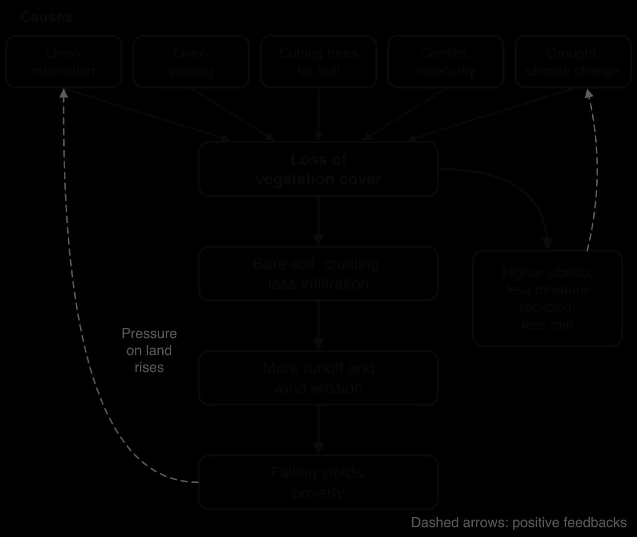
Once degradation starts, several positive feedback loops can speed it up, so that a small initial loss of vegetation leads to a much larger one.
The Charney hypothesis describes a biophysical loop. Bare, pale soil reflects more sunlight than vegetation (its albedo is higher), so the surface absorbs less energy and the air above it is less likely to rise and form rain clouds. Less vegetation also means less water returned to the air by transpiration. Both reduce rainfall, which reduces vegetation further.
A second, soil-based loop works at the field scale: bare soil forms a crust when raindrops strike it, so less water infiltrates and more runs off, carrying the fertile topsoil with it. A third loop is human: as yields fall, poor households must cultivate more land and keep more animals to survive, which degrades more land.
Soil erosion by wind and water removes the most fertile topsoil; gullies cut into fields and wind lifts fine particles into dust storms.
Falling yields of crops, fodder and fuelwood, so households have less food and less income.
Food insecurity: food security falls, and droughts on degraded land can lead to famine when other failures (prices, conflict, weak governance) occur at the same time.
Migration to towns, to wetter regions or abroad, often of young adults seeking work, leaving others to manage degraded land.
Conflict between herders and farmers as grazing land and water become scarcer and fields spread onto old livestock routes.
Biodiversity loss, as dryland plants and the animals that depend on them disappear, and dust that affects health and air quality hundreds or thousands of kilometres away.
The consequences vary with scale. At the field scale, desertification means a farmer harvesting less millet each year; at the national scale, it raises food imports and pushes people towards cities; at the regional and global scales, it contributes to migration, dust and the loss of carbon stored in dryland soils. They also vary by group: households with land rights, savings and livestock can cope with a bad year, while landless families and those dependent on one crop become more vulnerable.
Strategies range from large, state-led programmes to small changes in how individual farmers manage their land. They also differ in what they treat: some plant trees, some change land use, and some tackle the underlying causes such as land rights and poverty.
Farmer-managed natural regeneration works because the roots of many dryland trees survive underground long after the trees have been cut. Farmers choose the strongest shoots on each stump, remove the rest and protect them from livestock. Within a few years the trees shade the soil, reduce wind speed, add leaf litter and provide fodder, fuelwood and fruit. Faidherbia albida, a nitrogen-fixing tree that loses its leaves in the wet season so that it does not shade crops, is especially valued.
Zai pits were developed by farmers in the Yatenga region of Burkina Faso, where the farmer Yacouba Sawadogo became known for restoring degraded land with them. Termites attracted by the manure dig channels that help water infiltrate. Stone lines built along the contour slow runoff and trap soil. Both methods are cheap, use local labour and materials, and can be adopted one field at a time.
The Great Green Wall was first planned as a strip of trees 15 km wide and 7,775 km long from Dakar to Djibouti. It has since become a broader programme of water harvesting, improved land use and natural regeneration in more than 20 countries, with 2030 targets of 100 million hectares restored, 250 million tonnes of CO₂ captured and 10 million jobs created. At the One Planet Summit in January 2021, donors pledged US$14.3 billion, but only about US$2.5 billion had been disbursed by March 2023, against an estimated total cost of about US$33 billion.
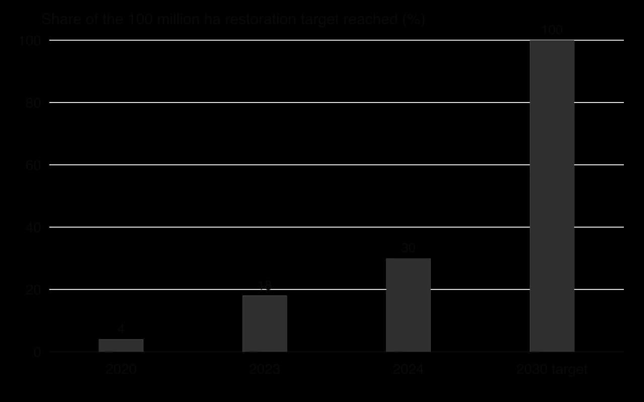
The chart shows that progress has been far slower than planned. Ethiopia, Senegal and Nigeria have made the most progress, but many planted trees have died, insurgency and locusts have disrupted work, and in 2023 the initiative was described as at risk of collapse because of insecurity, weak political leadership and lack of funds. Critics also argue that the original idea had colonial roots and was imposed from the top down.
China’s Three-North Shelterbelt Forest Programme, begun in 1978 and planned to run until about 2050, has planted at least 30 million hectares of trees across the arid north. Officials report fewer dust storms and a shrinking Gobi, but a 2023 study found that only about a tenth of planted forest survived for 40 years, monoculture poplars have suffered mass disease losses, and trees planted in drylands can lower water tables. In the Kubuqi Desert in Inner Mongolia, a partnership between the government and the Elion company has restored about a third of the 18,600 km² desert since 1988 with drought-tolerant plants and solar farms.
Other approaches include grazing management that protects herders’ mobility, land tenure reform that gives farmers secure rights, drought-tolerant millet and sorghum, and improved cookstoves that reduce fuelwood cutting.
Strategy | Strengths | Limitations | Who controls it |
|---|---|---|---|
FMNR | Very cheap; uses existing roots; fast; raises yields, fodder and fuel; spreads farmer to farmer | Needs secure tree rights and protection from livestock; benefits depend on local rules | Farmers and communities (bottom-up) |
Zai pits and stone lines | Cheap; restores crusted land; increases infiltration and yields | Labour-intensive; needs manure; works field by field | Farmers (bottom-up) |
Great Green Wall | Regional scale; political attention; funding for many countries | Behind target; low tree survival in places; insecurity; funds slow to arrive | Governments and donors (top-down, now more mixed) |
Three-North Shelterbelt | Huge scale; reported fall in dust storms | Low survival; monocultures; water use by trees | Central government (top-down) |
The evidence suggests that bottom-up methods that farmers control and that address the causes of degradation have restored more land, more cheaply, than top-down tree-planting schemes. Large programmes are not useless: they bring funding and attention, and the Great Green Wall has improved partly by adopting farmer-led methods. Their success depends on security, secure land and tree rights, and the involvement of the people who use the land.
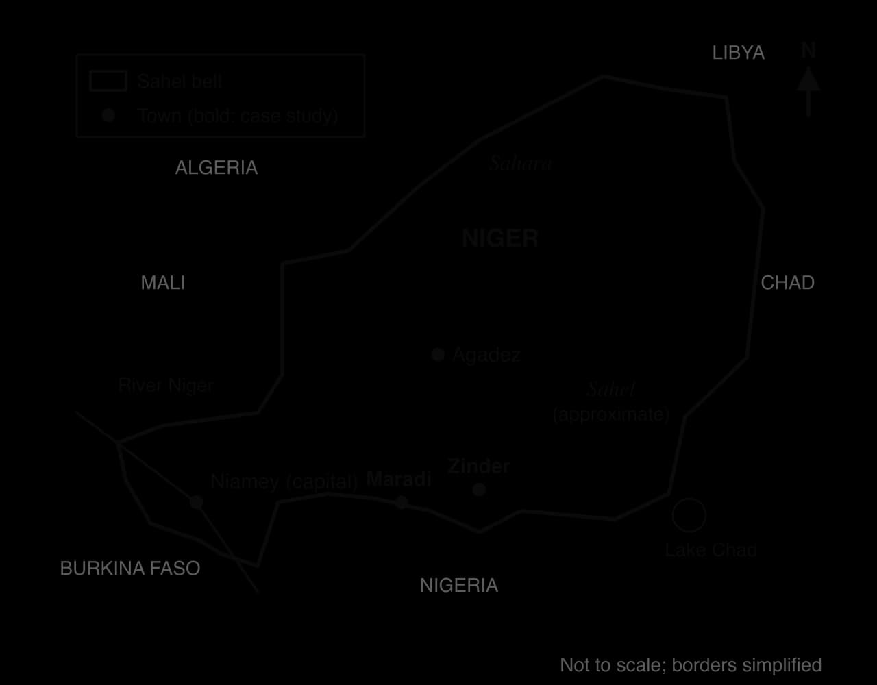
The Sahel is the semi-arid belt south of the Sahara, stretching across Africa from Senegal to Sudan and Eritrea. Rainfall falls in a single summer season and rises from about 100–200 mm a year at the desert edge to 700–1,000 mm in the south. Niger lies across the boundary: its north is Sahara, and almost all of its people live in the southern Sahelian strip, where the Maradi and Zinder regions border Nigeria. Most households grow millet and sorghum on rain-fed fields and keep cattle, goats and sheep.
Rainfall in the Sahel fell sharply after the late 1960s. The column chart shows that summer rainfall was well above the 1980–2009 average through the 1950s and most of the 1960s, then mostly below it from 1968 until the late 1980s, with the driest year in 1984. Since the 1990s rainfall has partly recovered, with several wet years in the 2010s, although totals vary greatly from year to year.
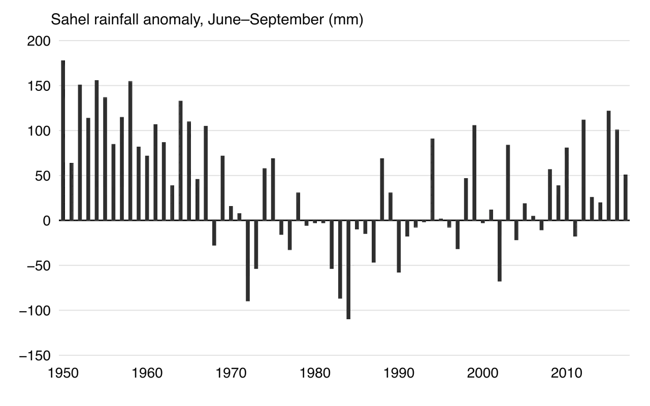
The droughts and the famines of the late 1960s to early 1980s killed about 100,000 people, left about 750,000 dependent on food aid and affected most of the Sahel’s then 50 million people. Scientists now attribute the drought largely to changes in sea-surface temperatures in the oceans, possibly influenced by air pollution in the northern hemisphere, amplified by vegetation loss on land through the Charney feedback.
Niger’s population grew from about 3.5 million in 1960 to about 27 million in 2024, and its fertility rate of about 6.1 births per woman in 2023 was among the highest in the world. Fields expanded and fallows shortened, so that by the 1980s much of the farmland in Maradi and Zinder had been cleared of trees, leaving soils exposed to wind and to intense summer storms. Under forestry laws dating from the colonial period, trees belonged to the state until 1993, so farmers had little reason to protect them.
FMNR began in 1983, when the Australian agronomist Tony Rinaudo, working for the mission organisation SIM, began experimenting with about ten farmers in the Maradi region. During the 1984 famine, a food-for-work programme spread the method to about 70,000 people on roughly 12,500 hectares. After the forestry law changed in 1993 and farmers gained the right to own and use the trees in their fields, the practice spread rapidly from farmer to farmer. By 2004 FMNR was being practised on over 5 million hectares, about half of Niger’s farmland, described by one researcher as probably the largest positive environmental transformation in the Sahel.
Satellite data show the change. Healthy leaves absorb red light and reflect near-infrared light strongly, so the NDVI of a vegetated area is high. Images of southern Niger show a “greening” of large areas since the 1980s; scientists debate how much is due to the return of rainfall and how much to FMNR, but the density of trees on farmland in Maradi and Zinder shows that management, not only rain, has changed the landscape.
Group | Effect of desertification | Effect of re-greening |
|---|---|---|
Smallholder farmers | Falling millet yields, wind erosion of fields, food shortages in drought years | Trials suggest FMNR can at least double yields on poor soils; income from fuelwood, timber and fodder |
Women | Long walks to collect fuelwood and water | Shorter trips for firewood, more time for other work |
Herders | Loss of pasture; conflict with farmers over land | More fodder from trees, but more fields on former grazing land |
National government | Food imports, famine relief, outmigration | Lower relief costs; an example for national and regional programmes |
Niger is one of the Great Green Wall countries, and FMNR is now part of the initiative’s approach. But progress across the Sahel remains far behind target, and in recent years insecurity and armed attacks in parts of Niger, and a military coup in 2023, have made programmes harder to run. Population growth continues, rainfall remains highly variable, and climate projections for the Sahel are uncertain, so re-greening is not a permanent solution unless land rights, farmers’ incomes and security improve as well.
 YouTube
Key concept | In the Sahel case study |
|---|---|
Process | Drought, vegetation loss and positive feedbacks; natural regeneration from living roots |
Power | Colonial-era forestry law kept tree ownership with the state; giving farmers rights to trees in 1993 allowed re-greening |
Place | Southern Niger’s Sahelian strip, where dense population meets highly variable rainfall |
Possibility | Re-greening shows degradation can be reversed; climate uncertainty and insecurity limit what is possible |
Analysis questions
Examine the relative importance of physical and human causes of desertification in the Sahel since 1968.
Explain why FMNR spread so rapidly after 1993.
To what extent can the Great Green Wall succeed without the involvement of local farmers?
Sources: NOAA Physical Sciences Laboratory, Sahel rainfall index (JISAO), 2019; World Bank, World Development Indicators, 2026; Wikipedia, “Sahel”, “Farmer-managed natural regeneration” and “Great Green Wall (Africa)”, accessed 2026.
Extreme environments were once valued mainly by the people who lived in them. Rising demand for minerals, energy and food, new technology and the loss of ice have made their resources accessible and valuable to outsiders, so more groups now compete for the same land, water and seas. The contested resources include minerals and hydrocarbons, grazing land, water, fish, shipping routes and, increasingly, land for renewable energy such as wind and solar farms.
Indigenous peoples such as the Inuit of the Arctic, the Sámi of northern Scandinavia, the Tuareg of the Sahara and Aboriginal Australians have used these environments for centuries or millennia. Their interests are to keep access to land for herding, hunting and fishing, protect sacred sites, and share in the benefits of any development. Their power comes from land claims, international law and public opinion rather than money or force, and it varies greatly between countries.
The UNDRIP was adopted on 13 September 2007 by 143 votes to 4. The four countries that voted against, Australia, Canada, New Zealand and the United States, all have large Indigenous populations and extensive extreme environments; all four later endorsed it, though the United States interpreted consent as meaningful consultation rather than agreement.
Free, prior and informed consent is the most contested principle in the declaration. Indigenous organisations argue that it amounts to a right to say no; governments and companies usually treat it as a duty to consult. The difference decides whether a mine or wind farm can go ahead against local opposition.
Impact–benefit agreements are widely used for mines in northern Canada. They can bring jobs and income to remote communities, but critics point out that they are often confidential, negotiated between unequal partners, and signed after the main decisions have been made.
Civil society organisations (CSOs) are non-governmental, non-profit groups such as environmental NGOs, Indigenous organisations, unions and local associations. Their power comes from publicity, legal action and lobbying. Greenpeace has campaigned against oil drilling in the Arctic: in September 2013 Russian coastguards seized its ship Arctic Sunrise and detained 30 activists after a protest at Gazprom’s Prirazlomnaya platform in the Pechora Sea, and in 2015 an international arbitration tribunal found that Russia had acted unlawfully. Smaller local organisations matter as much: farmers’ associations in the Sahel and Sámi herding associations represent the people most affected.
TNCs have the capital and technology to develop resources in extreme environments, and their power comes from investment, jobs and tax revenue for host governments. Their decisions depend on costs and prices. Shell spent years preparing to drill in the Chukchi Sea off Alaska, delayed drilling in 2012 because of heavy sea ice and an oil-spill response vessel that was not ready, and in September 2015 abandoned Alaskan Arctic exploration “for the foreseeable future” after disappointing results. Physical conditions, regulation and campaigners together raised the costs beyond what the company was willing to pay.
Militias often draw income from the informal mining that grows where state control is weak.
In parts of the Sahara and Sahel, militia groups compete for resources by force. Gold discoveries since the 2010s have drawn thousands of people into artisanal mining, and armed groups tax, protect or control mining sites, using the income to fund their operations. In Sudan, the paramilitary Rapid Support Forces took over gold mines in Darfur in 2017, and investigators linked a company run by the commander’s family to the trade, with much Sudanese gold sold through Dubai. Where states are weak, militias can hold more power over resources than governments, communities or companies, and the profits can prolong conflict.
The Lake Chad basin, shared by Chad, Cameroon, Niger and Nigeria, shows competition for water, fish and grazing turning violent. The lake’s open water shrank greatly between the 1960s and the 1980s, and fishers, farmers and herders from all four countries followed the water onto the exposed lake bed and islands.
Since 2009 the armed groups Boko Haram and, from 2016, Islamic State West Africa Province (ISWAP) have operated around the lake, taxing fishing and farming in areas they control, while governments have at times banned fishing and trade to cut off the groups’ income. Millions of people in the basin have been displaced, so the people who depend most on the lake’s resources have the least security of access to them.
States hold the legal power to license resource use and the military power to enforce it, and they are often the decisive stakeholder. Their interests include revenue, energy security, national sovereignty and, in the Arctic, strategic position. State decisions can favour Indigenous rights, as in Greenland’s uranium ban, or override them, as when governments license projects on contested land.
Stakeholder | Main interests | Source of power | Example |
|---|---|---|---|
Indigenous groups | Land, livelihoods, culture, a share of benefits | Land claims, UNDRIP and FPIC, courts, public opinion | Sámi herders and the Fosen wind farms |
Civil society organisations | Environmental protection, human rights | Publicity, legal action, lobbying | Greenpeace’s Arctic campaigns |
TNCs | Profit, secure supply | Capital, technology, jobs and taxes | Shell in the Chukchi Sea (withdrew 2015) |
Militia groups | Income, territorial control | Force, weak state control | Armed control of gold mining in Darfur |
States | Revenue, energy security, sovereignty | Law, licences, armed forces | Norway licensing the Fosen wind farms |
The voices that dominate are usually those with money, legal authority or force: states, TNCs and, where states are weak, militias. Indigenous groups and local communities gain power when they have recognised land rights, courts that enforce them and public support, as in Norway and Greenland, and lose it where these are absent.
Benefit-sharing and impact–benefit agreements can give local people a share of the value, but they rarely give them the right to refuse. Competition also has a new dimension: the energy transition creates demand for land for wind and solar farms and for minerals such as lithium, so projects that help to cut global emissions can still harm local communities.
The Fosen Vind project on the Fosen peninsula in Trøndelag, central Norway, is a complex of six onshore wind farms with 278 turbines and a capacity of 1,000 MW, commissioned in 2018–20 at a cost of about €1.1 billion. The state-owned company Statkraft holds 52.1%, and about a third of the output is sold to the aluminium producer Norsk Hydro. Two of the farms, Storheia and Roan, were built on winter grazing land used by southern Sámi reindeer herders.
The herders argued that the turbines, roads and noise made the land unusable for reindeer in winter. In October 2021 Norway’s Supreme Court ruled that the licences for Storheia and Roan violated the herders’ right to practise their culture under the International Covenant on Civil and Political Rights, but it did not say what should happen to the turbines, and they kept running. In February 2023, 500 days after the ruling, Sámi activists and supporters, including Greta Thunberg, occupied the entrance of the energy ministry in Oslo.
Agreements followed only after mediation. In December 2023 the southern herders, whose land lies under Storheia, agreed with the energy ministry on additional grazing areas, compensation and a veto over further operation when the licence ends. On 6 March 2024 the northern herders agreed with the owners of Roan on additional winter grazing land, annual compensation and a veto over any extension of the licences beyond 2045, so the turbines stay.
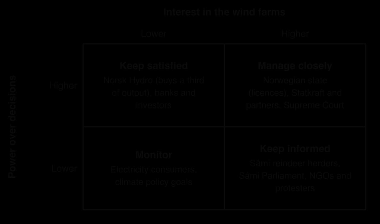
Fosen shows competition between two goals that are both called sustainable: renewable energy to cut emissions, and the survival of an Indigenous culture tied to land. It shows that legal rights matter, since the court ruling forced the state to negotiate, but also that a court victory does not automatically change what happens on the ground.
Sources: Wikipedia, “Fosen Vind”, accessed 2026; Reuters, “Norway ends dispute with reindeer herders over wind farm”, 6 March 2024.
New technology widens the possibilities for living in and using extreme environments. The test of whether it brings sustainable development is threefold: whether it protects the environment, whether it benefits local people as well as distant investors, and whether it pays its way over the long term.
Hot deserts receive more sunshine than anywhere else on Earth: skies are clear, the sun is high, and there is little cloud or humidity to absorb radiation. Land is cheap and sparsely settled, so very large plants can be built. Solar power can therefore supply cities, industry and desalination plants, and in principle export electricity to other regions. It is generated in two ways.
The second method uses heat rather than light.
Feature | Photovoltaic (PV) | Concentrated solar power (CSP) |
|---|---|---|
How it works | Cells convert light directly into electricity | Mirrors concentrate sunlight to heat a fluid that drives a turbine |
Storage | Needs batteries | Heat stored in molten salt for several hours |
Cost | Low and falling fast; the most common type | Higher; fewer new plants |
Water use | Small: panel cleaning | Larger if wet-cooled; dry cooling reduces it |
Scale | From a single home or pump to gigawatt parks | Large plants only |
Example | Benban Solar Park, Egypt (1.8 GW, completed 2019) | Noor Ouarzazate, Morocco (510 MW of CSP) |
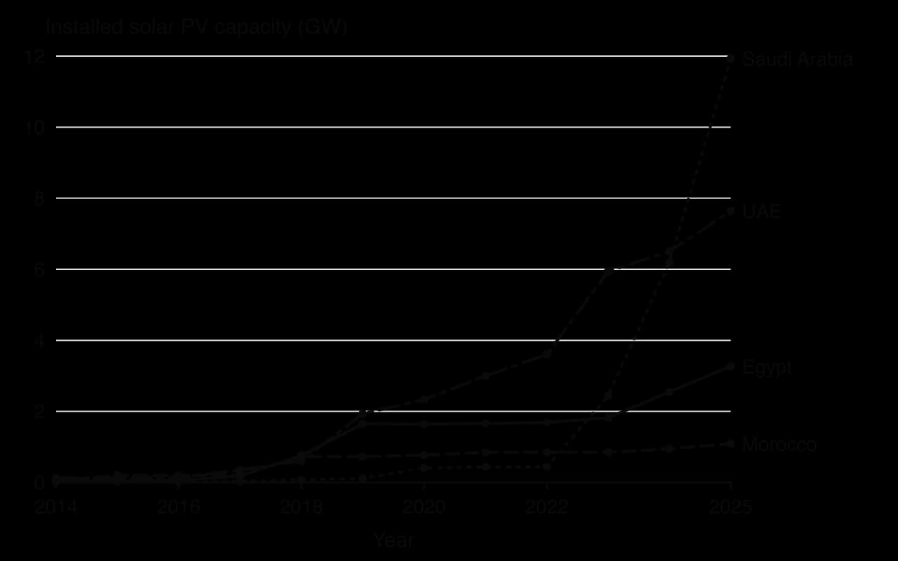
Photovoltaic panels are now so cheap that almost all new desert solar capacity is PV. The Benban Solar Park in Egypt’s Western Desert, 40 km north-west of Aswan, consists of 41 separate plants built by different companies on 37 km², with a total capacity of 1.8 GW, and was completed in November 2019. The Bhadla Solar Park in the Thar Desert of Rajasthan, India, has an even larger capacity of about 2.2 GW.
Concentrated solar power costs more but can store heat: at the Noor Ouarzazate complex in Morocco, on the edge of the Sahara, the 160 MW Noor I plant stores three hours of heat and Noor II and III store seven hours, so they can supply power into the evening. The complex has 510 MW of CSP and 72 MW of PV, cost about US$9 billion and was financed partly by the World Bank and the African Development Bank.
Dust settles on panels and mirrors and can sharply reduce output, so they must be cleaned frequently, which in a desert uses scarce water or labour.
Heat lowers the efficiency of PV cells: panels produce less electricity when very hot.
Water for cooling. Wet-cooled CSP plants use large volumes: Noor I uses about 4.6 litres per kWh, and the Ouarzazate complex draws 2.5–3 million m³ a year from a reservoir in a water-scarce region, which is why Noor II and III were built with dry cooling.
Land rights. Desert land that looks empty may be used by herders or claimed by local communities.
Who benefits. Plans to export desert power to Europe, such as the Desertec concept of the 2000s, raised the question of whether local people would benefit from electricity generated on their land; Desertec largely stalled. A later plan, the Xlinks Morocco–UK Power Project, proposed solar and wind farms in southern Morocco linked to England by a 4,000 km undersea cable carrying 3.6 GW, but the UK government rejected it in June 2025.
Desalination removes salt from seawater or brackish groundwater to produce fresh water. Global capacity grew from about 27 million m³ a day in 2003 to about 99 million m³ a day in 2023, much of it in the Persian Gulf states, North Africa and other arid coastlines. Israel now obtains most of its domestic water from a chain of large reverse osmosis plants on its Mediterranean coast, including Sorek south of Tel Aviv, and Perth in Western Australia has turned to desalination as rainfall in its catchments has declined.
Reverse osmosis has become the main method because it uses less energy than thermal desalination, in which seawater is heated and evaporated, as in multi-stage flash plants. Seawater reverse osmosis uses about 3–5.5 kWh of electricity per cubic metre, while multi-stage flash also needs large amounts of heat.

Desalination has three main problems. It needs large amounts of energy, and in the Middle East and North Africa over 95% of that energy comes from fossil fuels, so it adds to the emissions driving climate change. It produces brine, estimated at about 142 million m³ a day worldwide, which is denser than seawater, sinks and can harm seabed ecosystems near outfalls. And it is costly, although the best plants have reduced costs to under US$0.50 per m³. Powering plants with solar energy and diluting brine with diffusers can reduce the first two problems.
Fog harvesting suits coastal deserts such as the Atacama in Chile, where fog rolls in from the cold Pacific, and the Anti-Atlas mountains of Morocco, where the NGO Dar Si Hmad built a large system in 2015. It needs no energy and is cheap, but yields vary with the season and with events such as El Niño. At Chungungo in Chile, 94 fog collectors were installed to supply about 300 people, but by 2002 only nine were still working, which shows that maintenance and community ownership matter as much as the technology.
Other technologies include drip irrigation with soil-moisture sensors, small solar pumps and mini-grids for Sahelian villages, mobile phones and satellite data that give pastoralists forecasts and market prices, and thermosyphons and pile foundations on permafrost.
Technology | Environmental | Social | Economic |
|---|---|---|---|
Large solar parks (Benban, Noor) | Low-carbon power; water use for cooling and cleaning | Few permanent local jobs; land claims | High capital cost, falling generation cost |
Desalination | High energy use; brine | Reliable water for cities | Costly; often subsidised |
Fog harvesting | Very low impact | Benefits villages directly | Cheap but small-scale; needs maintenance |
Solar pumps and mini-grids | Low-carbon; risk of overpumping groundwater | Benefits households directly | Affordable with support |
Large-scale technologies such as solar parks and desalination plants transform supply at the national scale, but their benefits flow mainly to cities, industry and investors. Small-scale technologies benefit local people directly and cheaply but cannot meet national demand. Technology is most sustainable when it is matched to the place, owned or maintained locally, and powered by renewable energy.
Global climate change is felt most strongly in cold environments. Since 1979 the Arctic has warmed nearly four times faster than the global average, a pattern called Arctic amplification. The main reason is the ice–albedo positive feedback: as bright snow and ice melt, darker ocean and land absorb more sunlight and warm further.
Sea ice is measured by satellite as its extent, the area of ocean with at least 15% ice cover. The September minimum has fallen from about 7 million km² around 1980 to between 4 and 5 million km² in the 2020s, with a record low of 3.57 million km² in 2012. The linear trend is a loss of about 0.74 million km² per decade, about 12% per decade relative to the 1981–2010 average.
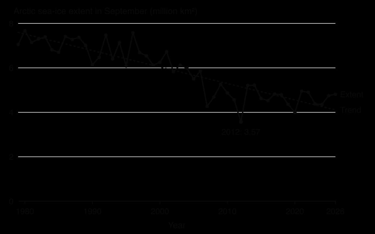
Loss of sea ice affects people in contrasting ways. Inuit hunters lose the ice platform they travel and hunt on, and coastal villages lose the ice that protected them from autumn storms. At the same time, longer ice-free seasons open shipping routes and offshore resources, which increases the competition for Arctic resources.
Permafrost thaw damages buildings, roads, pipelines and airstrips, as the Norilsk fuel spill of 2020 showed, and creates thermokarst landscapes of collapsing ground and thaw lakes. It is also a global problem: permafrost stores large amounts of carbon in frozen organic matter, and as it thaws, microbes release this carbon as greenhouse gases, a positive feedback on global warming. Longyearbyen on Svalbard, where deep permafrost has warmed since 2009 and an avalanche destroyed 11 houses and killed two people in December 2015, shows how warming adds new hazards to a town built on frozen ground.
Where thawing permafrost meets an ice-free sea, coasts erode quickly. Newtok, a Yup’ik village in western Alaska, lost land to the Ningliq River as permafrost thawed and protective ice disappeared. Residents voted in 2003 to move to a new site, Mertarvik, on Nelson Island about 14 km away. The first families moved in 2019, and by late 2024 Newtok, which had 354 residents in 2010, was abandoned.
Shishmaref, an Iñupiat village on a barrier island off north-west Alaska, faces the same threat with a different outcome so far. Its shore has retreated by up to about 3 m a year as sea ice that once buffered storm surges has thinned and the permafrost beneath the island thaws. Residents have voted to relocate, but a planned mainland site proved unsuitable because of thawing permafrost, and a move estimated at about US$180 million has not been funded, so the village depends on sea walls in the meantime.
Climate relocation is the last resort of adaptation. It protects lives, but it is expensive, slow and disruptive: Newtok’s move took more than 20 years from the vote to the abandonment of the old village, and new homes, a school and services had to be built from scratch.
Mountain glacier retreat threatens water supplies for millions of people downstream. The glaciers of the Himalaya, Hindu Kush and Andes act as “water towers”, releasing meltwater in the dry season. As they shrink, meltwater first increases and then declines once the ice is gone. Retreat also creates a hazard.
As a glacier retreats, meltwater collects behind the terminal moraine that marks its former snout. Moraines are loose, unsorted debris that can fail suddenly. A glacial lake outburst flood can send millions of cubic metres of water and debris down a valley in hours.
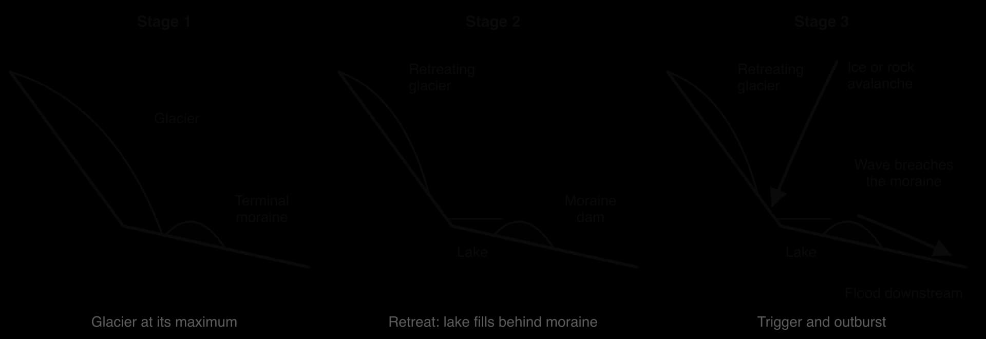
Imja Tsho, at about 5,010 m below Everest in Nepal, began as a few small ponds on the Imja Glacier in the 1960s and had grown to about 1.06 km² by 2009, making it one of the fastest-growing glacial lakes in the Himalaya. In 2016 the UNDP, the Nepal Army and the Department of Hydrology and Meteorology cut a controlled outlet through the moraine and drained over 4 million m³ of water to lower the risk. Lowering lakes is costly and difficult at high altitude, so it is used only for the most dangerous lakes; others rely on monitoring and early warning.
 YouTube
Higher temperatures and heatwaves raise evaporation, crop water stress and the risk of heat stress.
More variable rainfall, with longer droughts and more intense storms, so more flash floods on bare ground.
Greater desertification risk, as heat and drought add to human pressure on dryland soils.
More dust storms from dry, bare surfaces.
Wet-bulb temperature matters because sweating only cools the body if sweat can evaporate. In very humid heat, evaporation slows, and above a sustained wet-bulb temperature of about 35 °C even a fit person resting in the shade cannot lose heat and will die. A 2022 study found that the real limit for young, healthy adults is 5–10 °C lower.
Wet-bulb temperatures above 35 °C have already been recorded, though only for an hour or two and over small areas, on the Persian Gulf coast and in Pakistan’s Indus valley, where hot desert air meets very humid sea air or irrigated land. Projections suggest that parts of south-west Asia could exceed this threshold more often later this century. Inland deserts are drier, so wet-bulb temperatures there stay lower, but outdoor workers on building sites and farms still face dangerous heat.
Adaptation means adjusting to the effects of climate change to reduce harm or take advantage of new opportunities, as distinct from mitigation, which reduces emissions. In extreme environments much adaptation is done by local people themselves, often drawing on indigenous knowledge.
Inuit hunters combine traditional knowledge of ice with GPS, satellite images and community ice-monitoring programmes to judge where it is safe to travel; on SIKU, a mobile app and website created with Inuit communities, hunters share photos and reports of ice conditions.
Relocation, as at Newtok, when protection is no longer possible.
Engineering: deeper piles and thermosyphons that keep the ground frozen under buildings and pipelines.
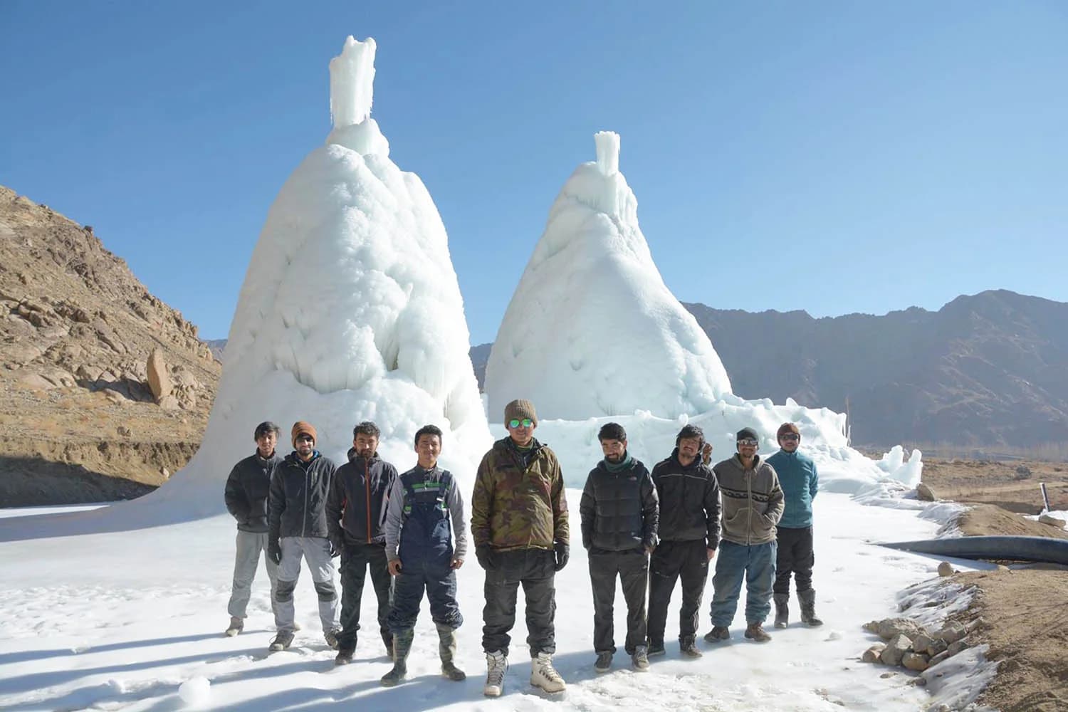
Artificial glaciers that store water for spring irrigation in the Himalaya.
Water harvesting in the Andes: in the Peruvian highlands, villages such as Huamantanga have restored amunas, pre-Inca stone channels that divert wet-season streams onto the hillsides so that the water soaks in and reappears in springs months later, when glacier melt no longer covers the dry season.
Ice stupas were developed in Ladakh, a high, cold desert in northern India, by the engineer Sonam Wangchuk and the NGO SECMOL. A prototype about 6 m high, made from 150,000 litres of water, was built in 2013–14. The cone shape exposes the least surface to the sun for the volume of ice it holds, so it melts slowly. Gravity provides the water pressure, so no pumps or electricity are needed. About 25 ice stupas were built in 2020, supplying water to villages whose natural glaciers are retreating.
Herders change livestock and routes, keeping more camels and goats, which tolerate drought better than cattle, and moving earlier or further.
Water harvesting, zai pits and FMNR, which also reduce desertification.
Drought-tolerant crops and changes in sowing dates.
Traditional building: thick walls, small windows, courtyards and wind towers that catch breezes, combined with modern insulation and cooling.
Adaptation has limits. Some communities cannot afford it, some places become too dangerous to protect, and some losses, such as a culture tied to sea ice or a glacier that has disappeared, cannot be replaced. The question of who should pay for loss and damage is an issue of equity, because the people of extreme environments have contributed least to the emissions that cause climate change.
Saúl Luciano Lliuya, a farmer from Huaraz in the Peruvian Andes, a city of about 120,000 people below the growing glacial Lake Palcacocha, sued the German energy company RWE. He argued that RWE was responsible for about 0.47% of historic greenhouse gas emissions and should pay the same share of the cost of protecting Huaraz from a GLOF.
On 28 May 2025 the Higher Regional Court in Hamm rejected the claim, after expert evidence put the risk of a flood reaching his house over the next 30 years at only about 1%; the court nevertheless accepted that, under German law, a large emitter can in principle be held responsible for its share of climate damage. The case shows how people in extreme environments are trying to hold distant emitters responsible, through spatial interactions that link a German power station to an Andean lake.
Response | Environment and example | Who acts | Limits |
|---|---|---|---|
Lowering a glacial lake | High mountains: Imja Tsho, Nepal (2016) | UN agency, army, government | Costly; possible only for the most dangerous lakes |
Artificial glaciers | Cold desert: ice stupas, Ladakh | Local NGO and villages | Depends on cold winters; small scale |
Relocation | Arctic coast: Newtok to Mertarvik, Alaska | Community with state and federal funding | Very slow and costly; loss of place |
Changing livestock and routes | Sahel | Herders | Depends on access to land and security |
Engineering | Permafrost: piles and thermosyphons in Alaska and Siberia | Companies and local governments | Expensive; protects only some structures |
Structured questions on extreme environments’ futures often use a rainfall or vegetation time series, a sea-ice graph, a map of a dryland region or a table of solar or desalination capacity. Extended questions usually ask you to evaluate the management of desertification or the effectiveness of adaptation, or to examine the roles of different stakeholders.
The table shows September Arctic sea-ice extent in selected years.
Year | 1980 | 1990 | 2000 | 2012 | 2020 | 2026 |
|---|---|---|---|---|---|---|
Extent (million km²) | 7.67 | 6.14 | 6.25 | 3.57 | 4.00 | 4.81 |
Source: NSIDC, Sea Ice Index, version 4, 2026.
A 10-mark answer needs well-evidenced examination of the whole question and a conclusion grounded in concepts or perspectives for the top band.
Desertification is long-term land degradation in drylands from climatic variations and human activities; it is not the same as drought or natural desert expansion.
Its causes (overgrazing, overcultivation, fuelwood cutting, poor irrigation, sedentarisation, conflict and climate change) interact, and positive feedbacks such as the Charney hypothesis accelerate it.
FMNR and water harvesting have restored land cheaply in Niger and Burkina Faso; the Great Green Wall and China’s shelterbelt are larger but less effective so far.
The Sahel shows the interaction of drought (1968 to the late 1980s), population growth, tree tenure and re-greening since the 1980s.
Competition for resources involves Indigenous groups, civil society organisations, TNCs, militia groups and states, each with different sources of power.
Solar power and desalination can support development in deserts but use water and energy and may benefit distant users more than local people.
Climate change is fastest in the Arctic: sea-ice loss, permafrost thaw, coastal erosion and glacial lake outburst floods; arid areas face heat, drought and variable rainfall.
Local adaptation includes ice stupas, lowering glacial lakes, relocation and changing livestock, but adaptation has limits and raises questions of loss and damage.
I can distinguish desertification from drought and from natural desert expansion.
I can explain the human, conflict and climatic causes of desertification and its positive feedbacks.
I can evaluate FMNR, zai pits, the Great Green Wall and China’s shelterbelt.
I can use the Sahel and Niger case study, with data, to explain the human and physical dimensions of desertification.
I can examine the roles and power of Indigenous groups, civil society organisations, TNCs, militia groups and states, using the Fosen example.
I can evaluate solar power and desalination as technologies for sustainable development.
I can explain the impacts of climate change on cold and hot arid environments with located examples.
I can evaluate local adaptation to climate change and its limits.
Good answers may be well structured (AO4) and may additionally offer a critical evaluation (AO3) which recognizes time lags: snouts may take years to decades to respond to a change in mass balance, so landforms record a delayed and smoothed signal of climate. Another approach might be to argue that mass balance controls where and when landforms are made, while geology and relief control what kind of landforms result. Some answers may consider scale, from seasonal changes (winter accumulation, summer ablation; annual push moraines) to glacial–interglacial cycles, and the possibilities of further change as climate warms.
For 5–6 marks, expect some weakly-evidenced outlining of glacier mass balance and/or one or more glacial landforms.
For 7–8 marks, expect a structured account which includes:
either well-evidenced explanation of how changes in mass balance influence the development of two or more landforms
or a discursive conclusion (or ongoing evaluation) of the strength of the relationship, grounded in geographical concepts and/or perspectives.
For 9–10 marks, expect both of these traits.
NB. Maximum [4] if mass balance is described but not linked to landforms.
Marks | Level descriptor |
|---|---|
0 | The response does not reach a standard described by the descriptors below. |
1–2 | Too brief, lists unconnected information, not focused on the question and lacks structure. Knowledge is very general, with large gaps or errors; examples or case studies are missing or only listed. No analysis; terminology is missing or used incorrectly. |
3–4 | Too general, lacks detail, not focused on the question and largely unstructured. Outlines examples, statistics and facts, both relevant and irrelevant, with links to the question only listed. Basic terminology is used, with errors or inconsistently. No critical evaluation of evidence; any conclusion is irrelevant. |
5–6 | Partially addresses the question, with a narrow argument, an unsubstantiated conclusion and limited evaluation. Describes relevant supporting evidence (examples, case studies) and outlines links to the question. The argument repeats one point or covers only part of the question. Other perspectives, or strengths and weaknesses of evidence, are listed. |
7–8 | Addresses the whole question; the analysis is evaluated and the conclusion is relevant but lacks balance. Relevant evidence is described correctly and covers all the main points. The argument is clear but one-sided or unbalanced. Complex terminology is used correctly but not consistently. Other perspectives, or strengths and weaknesses of evidence, are described. |
9–10 | In-depth and specific to the question (topic and command term). Correct, relevant examples, statistics and detail are integrated and their link to the question explained. The argument is balanced, explaining complexity, exceptions and comparisons. Evaluation of evidence and perspectives is well developed, and the conclusion is balanced and aligned with the evidence. Logically structured and easy to follow. |
To what extent is the development of thermokarst landscapes the result of human activity rather than natural processes?
10 marks
Examine the possible effects of climate change on the physical processes and landscapes of glacial and periglacial environments.
10 marks