Explain how glacial, periglacial, wind and water processes create the landforms of cold and hot arid environments, from cirques, moraines and pingos to dunes, wadis, mesas and buttes, using named examples and real glacier data.
Each is in the Geography glossary, with every other term in the subject.
The loss of mass from a glacier by melting, sublimation, evaporation and calving; the zone of ablation is the lower part of a glacier, where annual losses exceed gains.
The addition of mass to a glacier by snowfall, avalanches, wind-blown snow and refreezing meltwater; the zone of accumulation is the upper part of a glacier, where annual gains exceed losses.
The surface layer of soil above permafrost that thaws each summer and refreezes each winter, from a few centimetres to several metres thick.
A fan-shaped deposit of sediment formed where a stream or flash flood leaves a narrow valley or mountain front and spreads out onto a plain; merged fans form a bajada.
A narrow, steep-sided rock ridge formed where two cirques or glacial troughs erode back towards each other.
A crescent-shaped dune with its horns pointing downwind and its slip face on the concave side, formed where sand is limited and the wind blows from one direction.
The movement of a glacier over its bed on a film of meltwater, possible only where the base is at the pressure melting point.
An isolated, steep-sided hill with a small flat top, higher than it is wide, formed as a mesa is worn back by weathering and erosion.
Describe a glacier as a system of inputs, stores and outputs, and explain how its mass balance controls advance and retreat.
Distinguish between warm-based and cold-based glaciers, and explain how glaciers move.
Explain the processes of glacial erosion, transportation and deposition.
Explain the formation of cirques, arêtes, pyramidal peaks, glacial troughs, glacial lakes, moraines and erratics.
Explain the periglacial processes of freeze-thaw, frost heave and solifluction, and the formation of permafrost features, patterned ground, pingos and thermokarst.
Explain physical and chemical weathering in hot arid environments, and erosion, transportation and deposition by wind and water.
Explain the formation of dunes, wadis, rock pedestals, mesas and buttes.
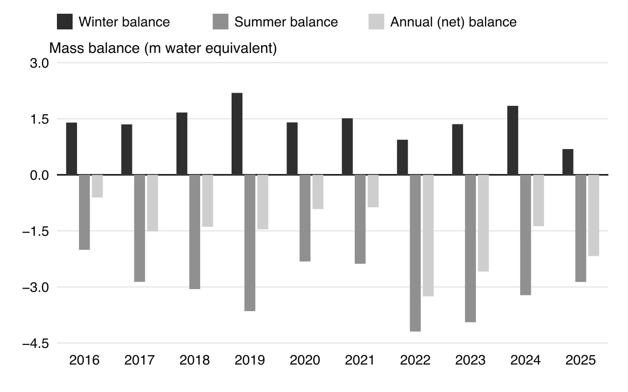
Construct and interpret a glacier mass balance graph and identify landforms from diagrams, maps and photographs.
Extreme environments have some of the most striking landscapes on Earth: knife-edged ridges and deep U-shaped valleys in glaciated mountains, ice-cored hills and polygons in the tundra, and sand seas, flat-topped mesas and dry valleys in deserts. Each landscape is the product of a particular set of physical processes working on rocks over thousands of years.
Ice, frost, wind and occasional floods are the main agents, and the climate of each place determines which of them dominates. Many landforms are also clues to the past: moraines and erratics record where ice once reached, and many desert landforms were shaped in wetter periods than today.
64 exam-style questions on this subtopic, written in the style of the IB papers. The first has its markscheme open. Counted on
Examine the relative importance of plucking and abrasion in the formation of erosional landforms in one or more named glaciated upland areas.
10 marks
Marks should be allocated according to the markbands.
Plucking (quarrying) occurs where meltwater at the base of the glacier freezes onto jointed or fractured bedrock and blocks are pulled away as the ice moves. Abrasion is the scouring of the bed by rock debris carried in the base of the ice, which acts like sandpaper. Both depend on the ice being warm-based (at the pressure melting point), so that it slides over its bed. Erosional landforms include cirques/corries, arêtes, pyramidal peaks/horns, glacial troughs (with truncated spurs and hanging valleys) and ribbon lakes, as well as smaller features such as roches moutonnées, striations and glacial polish. Credit references to other processes (eg freeze-thaw weathering of back walls, rotational flow) where they are linked to the effectiveness of plucking or abrasion.
Possible applied themes (AO2) demonstrating knowledge and understanding (AO1):
Plucking is most effective where rock is well jointed and where meltwater is available to refreeze; it is concentrated on the steep back walls of cirques and on the lee (downstream) side of bedrock obstacles, producing the jagged downstream face of a roche moutonnée.
Abrasion is most effective where basal debris is abundant and harder than the bedrock, and where ice is thick and moving fast; it smooths and polishes the stoss (upstream) side of obstacles and leaves striations aligned with ice flow.
In cirques, plucking steepens and lowers the back wall while abrasion under rotational flow deepens the floor, leaving a rock lip and often a tarn (eg Red Tarn below Helvellyn in the English Lake District; Llyn Idwal in Cwm Idwal, Snowdonia).
Arêtes (eg Striding Edge) and pyramidal peaks (eg the Matterhorn, 4478 m) form as plucking and freeze-thaw cut back the walls of adjacent cirques; abrasion plays a smaller part on these steep ridges.
With a free account, Augment remembers where you stopped and what you have practiced.
The decomposition of rock by chemical reactions that change its minerals, such as hydration, oxidation and solution; it needs water and is fastest in warm, wet climates.
An armchair-shaped hollow on a mountainside with a steep backwall, an over-deepened rock basin and a lip, eroded by a small glacier; it often holds a tarn after the ice melts.
A glacier whose base is below the pressure melting point and frozen to the bedrock, so it moves only slowly by internal deformation and does little erosion.
Permafrost that underlies 90–100% of the ground surface, found where mean annual temperatures are well below freezing; it is often hundreds of metres thick.
The removal of loose, fine particles from the ground surface by wind, which lowers the land and can form deflation hollows.
A surface layer of closely packed pebbles and stones left when deflation removes the finer particles, which then protects the ground from further wind erosion.
Permafrost that underlies 50–90% of the ground, broken by unfrozen areas beneath lakes, rivers and warmer slopes.
The line on a glacier, often given as an altitude, at which annual accumulation equals annual ablation, separating the zone of accumulation from the zone of ablation.
A rock fragment, often a large boulder, transported by ice and deposited far from its source on bedrock of a different type, showing the direction and extent of former ice.
Granular, compacted snow that has survived at least one summer melt season and is turning into glacier ice as burial squeezes out its air.
The breakdown of rock by repeated freezing and thawing of water in cracks and pores, which expands by about 9% when it freezes and pries the rock apart.
The upward swelling of the ground during freezing, caused by ice lenses growing in fine soil as water is drawn to the freezing front; it lifts stones towards the surface.
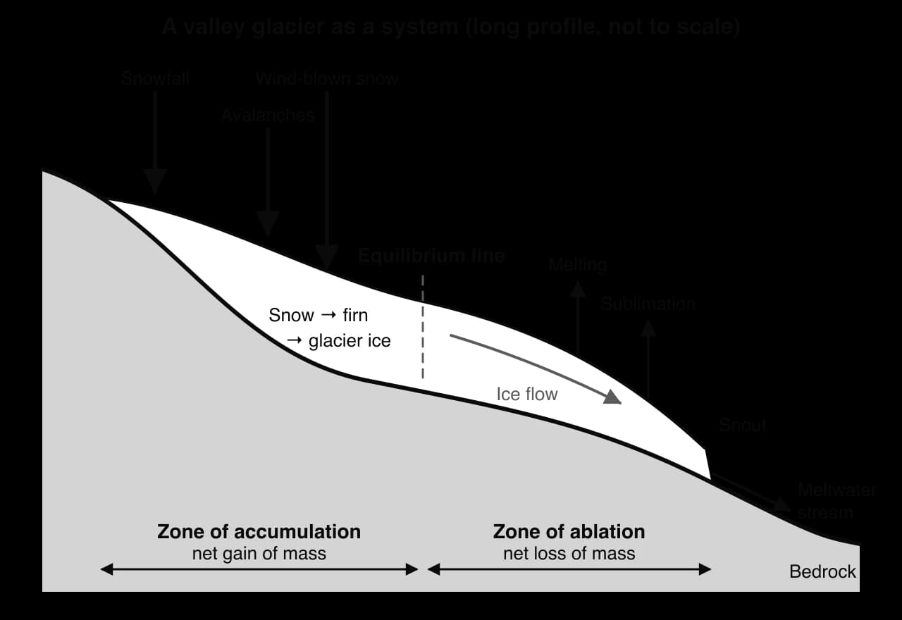
A glacier viewed as an open system, with inputs of snowfall, avalanches and wind-blown snow, stores of snow, firn and ice, transfers by ice flow, and outputs by melting, sublimation and calving.
A deep, straight valley with steep sides and a wide, flat floor, formed when a glacier deepens, widens and straightens a former river valley.
The difference between a glacier's accumulation and ablation over a year, usually in metres of water equivalent; a positive balance leads to advance, a negative balance to thinning and retreat.
A tributary valley whose floor lies high above the floor of a main glacial trough, because its smaller glacier eroded less deeply; its stream enters the trough by a waterfall.
The slow flow of glacier ice as individual ice crystals deform and slide past one another under the pressure of the ice above.
A ridge of till along the side of a glacier or glacial valley, formed mainly from rock that fell from the valley sides.
A fine, yellowish, unstratified silt deposited by wind, often far from the desert or glacial outwash from which it was blown; it forms fertile but easily eroded soils.
A band of debris running along the middle of a glacier, formed where the lateral moraines of two joining glaciers merge.
An isolated, flat-topped hill with steep sides, wider than it is high, left where a resistant caprock protects weaker horizontal rocks as the surrounding plateau is eroded.
A ridge or mound of till carried and deposited by a glacier, named by its position as lateral, medial, terminal or recessional.
Sorted, rounded and often layered sand and gravel deposited by meltwater streams beyond or beneath a glacier.
A regular pattern of stone circles, polygons, nets or stripes on the ground in periglacial areas, produced mainly by frost heave, sorting of stones and, on slopes, solifluction.
The breakdown of rock into smaller fragments without any change in its chemical composition, by processes such as thermal fracture, salt crystallisation and freeze-thaw.
A dome-shaped hill with a core of ice, up to about 70 m high, formed in permafrost areas when water under pressure freezes near the surface, in drained lake beds (closed system) or from rising groundwater (open system).
Glacial erosion in which meltwater freezes onto jointed bedrock, so that moving ice pulls away blocks of rock.
A steep, pointed mountain summit with three or more faces, formed where three or more cirques have eroded back into the same peak, leaving arêtes between them.
A long, narrow lake that fills an over-deepened rock basin on the floor of a glacial trough.
An isolated rock with a narrow, undercut base and a wider cap, formed mainly by wind abrasion concentrated near the ground, helped by weathering at the base.
The physical weathering of rock by the growth and expansion of salt crystals in pores and cracks as salty water evaporates, which forces grains apart.
A long, narrow, sharp-crested dune lying parallel to the average of two seasonal wind directions, which can stretch for tens to hundreds of kilometres.
The steep leeward side of a sand dune, standing at about 32–34°, down which sand avalanches after being blown over the crest.
The slow downslope flow of saturated soil, especially of the thawed active layer over impermeable permafrost, forming lobes and terraces.
A large pyramidal dune with three or more radiating arms, each with a slip face, formed by winds from several directions; it grows upwards and moves little.
A zone of unfrozen ground within or beneath permafrost, usually under a lake or river; it may be closed, open or through.
A ridge of till that forms across a valley at the furthest point reached by a glacier's snout, marking its maximum advance.
The physical weathering of rock by repeated heating and cooling, which makes the outer layers expand and contract more than the interior, so they crack and peel away.
An irregular landscape of hollows, mounds and thaw lakes formed when ice-rich permafrost thaws and the ground subsides.
Unsorted sediment of clay, sand, gravel and angular boulders deposited directly by glacier ice.
A steep-sided, flat-floored dry valley in a desert, cut mainly by flash floods, that carries water only briefly after heavy rain.
A glacier whose base is at the pressure melting point, so a film of meltwater lets it slide over its bed; it moves relatively fast and erodes strongly.
The wearing away of rock surfaces by sand grains carried by the wind, concentrated within about a metre of the ground.
Scope: The syllabus covers glacial processes of erosion, transport and deposition and the features of glaciated areas (cirques, lakes, pyramidal peaks, arêtes, glacial troughs, lateral, medial and terminal moraines and erratics); periglacial processes (freeze-thaw, solifluction, frost heave) and features (permafrost, thermokarst, patterned ground, pingos); physical and chemical weathering in hot arid environments and erosion, transportation and deposition by wind and water; and hot arid features (dunes, wadis, rock pedestals, mesas and buttes). No example is named by the syllabus. Extreme environments is one of seven options, from which SL students study two and HL students three.
A glacier can be studied as an open glacial system: mass enters as snow, is stored as ice, moves downhill and leaves as water vapour, meltwater or icebergs. Treating it as a system makes it possible to explain why a glacier grows or shrinks, and why it keeps flowing even when its snout is retreating.
The inputs are snowfall, avalanches from the valley sides and snow blown in by the wind. The main store is the ice itself, built up over years. Fresh snow is light and full of air; as it survives a summer and is buried by later snowfalls, its crystals become rounded and packed together into firn. Under further burial the air is squeezed out and the firn becomes dense, blue-white glacier ice.
The outputs are ablation: melting, sublimation (ice turning directly into water vapour in dry, sunny air), and calving, where blocks of ice break off a glacier ending in a lake or the sea. Glacier ice needs to be at least about 30 m thick before it starts to flow under its own weight.
In the upper part of a glacier, accumulation is greater than ablation over a year, so there is a net gain of mass; this is the zone of accumulation. In the lower part, ablation is greater, giving a net loss. The two zones are separated by the equilibrium line, where gains and losses balance. Ice flows from the zone of accumulation into the zone of ablation, transferring the surplus downhill.
In a healthy glacier the zone of accumulation covers about 60–70% of the surface. The share of the glacier above the equilibrium line, the accumulation area ratio, is therefore a quick guide to its condition. On the Great Aletsch Glacier in Switzerland it fell to only 11% in the extreme summer of 2022, when the equilibrium line rose to 3,605 m.
The glacier mass balance is the difference between total accumulation and total ablation over a year. Glaciologists measure the winter balance (snow added by the end of winter) and the summer balance (ice lost by the end of summer); their sum is the annual, or net, balance. Values are given in metres of water equivalent (m w.e.), the depth of water that the gained or lost mass would make if spread over the whole glacier.
The temperature at the base of a glacier controls how fast it moves and how much it erodes. The melting point of ice falls slightly under pressure, so the ice at the bottom of a thick glacier can be at its pressure melting point even when the air above is below freezing. Glaciers are therefore classed as warm-based or cold-based.
In the high Arctic and Antarctica the ice may be far below freezing all the way to the bed.
Characteristic | Warm-based (temperate) | Cold-based (polar) |
|---|---|---|
Basal temperature | At the pressure melting point | Below freezing; frozen to the bed |
Meltwater | Abundant at the base and in summer | Little or none |
Movement | Basal sliding and internal deformation; faster (the Aletsch moves about 180 m a year below Konkordiaplatz) | Internal deformation only; slow |
Erosion | High: plucking and abrasion are effective | Low: the ice can even protect the land beneath it |
Examples | Alpine glaciers, Icelandic glaciers, most Norwegian glaciers | Glaciers of Antarctica’s interior and the high Arctic |
Many large glaciers are polythermal: cold-based at their thin, frozen margins and warm-based beneath their thick centres. This explains why the landscapes beneath former ice sheets vary so much, with heavily eroded areas next to areas where old surfaces survived almost untouched under frozen ice.
Ice moves in two main ways. In internal deformation, the weight of the ice above makes ice crystals slide past one another and deform, so the glacier flows like a very stiff fluid. Deformation is greatest near the bed, where stress is highest, and ice moves fastest at the surface and the centre of the glacier, where friction with the bed and valley sides is least.
In basal sliding, the whole glacier slides over its bed on a thin layer of meltwater. Meltwater comes from summer melting that drains to the base, from geothermal heat and from friction. Regelation adds to it: on the upstream side of a bump in the bed, pressure melts the ice; the water flows round the obstacle and refreezes on the downstream side, where pressure is lower.
Where the valley floor steepens, the ice speeds up and stretches, a pattern called extending flow; the brittle surface ice, about the top 50 m, cracks into crevasses. Where the gradient eases, at the foot of an ice fall or near the snout, the ice slows, thickens and is squeezed, called compressing flow, which pushes material up towards the surface. In a cirque the ice moves in a curved, rotational path, which helps to over-deepen the hollow. Some glaciers also surge, moving many times faster than normal for months or years before slowing again.
Glaciers erode in two main ways. Plucking happens where meltwater at the base freezes onto jointed rock; as the ice moves on, it pulls away blocks of rock that are already loosened by joints and pressure release. Plucking is most effective on the downstream side of obstacles and on rock that is heavily jointed, such as granite.
Abrasion happens when rock fragments frozen into the base of the ice scrape the bed like sandpaper. Fine debris polishes the rock; larger stones cut parallel grooves called striations, which show the direction of ice movement. The products of abrasion, fine rock flour, give meltwater streams and glacial lakes their milky colour.
Freeze-thaw weathering on the exposed valley sides and backwalls supplies much of the debris that the ice carries and uses as a tool. The rate of erosion depends on the thickness and speed of the ice, the amount and hardness of debris it carries, the basal temperature (warm-based glaciers erode far more) and the jointing and hardness of the rock.
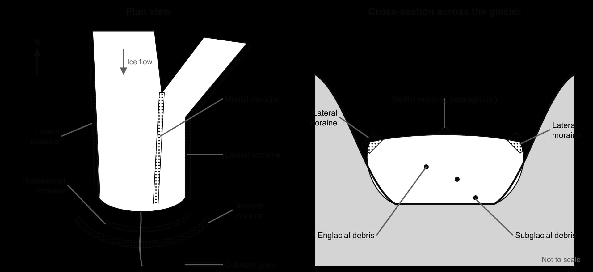
Debris is carried in three positions. Supraglacial debris lies on the surface, mostly rock that has fallen from the valley sides. Englacial debris is carried within the ice, after being buried by snow or falling into crevasses. Subglacial debris is dragged along at the base, where it is crushed and rounded slightly and used for abrasion. A glacier can carry material of any size, from rock flour to boulders the size of a house, because ice is not sorted by velocity as water is.
When ice melts, it drops its load. Material deposited directly by ice is till, which is unsorted, ranging from clay to boulders mixed together, and its stones are angular or sub-angular because they have not been rounded by water. Material carried and laid down by meltwater is outwash: it is sorted by size and its particles are rounded, because running water drops the largest particles first as it slows.
Meltwater, by contrast, sorts the sediment it carries.
Property | Till | Outwash |
|---|---|---|
Deposited by | Ice directly | Meltwater streams |
Sorting | Unsorted: all sizes mixed | Sorted by size, often in layers |
Shape of stones | Angular to sub-angular, sometimes striated | Rounded by water |
Landforms | Moraines, till plains, drumlins | Outwash plains (sandur), eskers, kames |
 YouTube
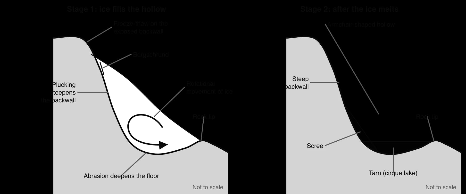
A cirque (called a corrie in Scotland and a cwm in Wales) is an armchair-shaped hollow high on a mountainside, with a steep backwall, a deepened floor and a raised rock lip at its front. Many glaciers begin in cirques, and cirques are the starting point for most other upland glacial landforms.
A cirque forms in stages:
Snow collects in a hollow that is sheltered from the Sun. In the northern hemisphere, hollows facing north and east are shaded and keep their snow longest, so most cirques there face north-east.
Nivation (freeze-thaw and meltwater under and around the snow patch) enlarges the hollow, and the snow is compacted into firn and then ice.
Rotational movement: as ice accumulates, it moves out of the hollow along a curved path, pivoting like a spoon. Pressure is greatest at the base of the backwall and on the floor.
Plucking at the backwall steepens it, helped by freeze-thaw on the exposed rock above the ice; a crevasse called the bergschrund opens where the moving ice pulls away from the backwall, letting meltwater reach the rock.
Abrasion by debris under the rotating ice deepens the floor, while erosion is weaker at the front, where the ice thins and moves upwards, leaving a rock lip (threshold).
After the ice melts, the basin often fills with water to form a tarn, dammed by the rock lip and sometimes by moraine.
Red Tarn, on the eastern side of Helvellyn in the English Lake District, is a classic example: a cirque lake at 718 m, 25 m deep, enclosed by steep backwalls and ridges. Cirque orientation can be analysed with a rose diagram, plotting the direction each cirque faces; in upland Britain, as across the mid-latitudes of the northern hemisphere, a large share face between north and east.
When two cirques erode back towards each other, or a cirque cuts back against a glacial trough, the ridge between them is narrowed into a sharp, knife-edged arête. Striding Edge, the arête between Red Tarn and Nethermost Cove on Helvellyn, is a well-known example.
Where three or more cirques erode into the same mountain from different sides, they leave a steep, angular summit called a pyramidal peak, or horn. The Matterhorn (4,478 m) on the Swiss–Italian border is the type example: its four steep faces, each roughly facing a point of the compass, are separated by four arêtes, the Hörnli, Furggen, Zmutt and Lion ridges.
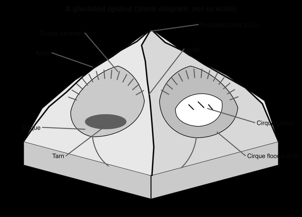
A valley glacier follows the course of an earlier river valley but reshapes it completely. A river valley in the mountains is V-shaped, with interlocking spurs. A glacier fills the whole valley and erodes its floor and sides by plucking and abrasion, so it deepens, widens and straightens the valley into a glacial trough with steep sides and a wide, flat floor.
Because the ice cannot bend round the interlocking spurs, it cuts them off, leaving steep cliffs called truncated spurs. Tributary valleys that held smaller glaciers were not deepened as much as the main valley, so after the ice melts they are left as hanging valleys high above the trough floor, with waterfalls where their streams drop into the main valley.

Yosemite Valley in California’s Sierra Nevada is about 12 km long and 910–1,070 m deep, with granite walls such as El Capitan; more than half a dozen creeks tumble from hanging valleys at the top of its cliffs, including Yosemite Falls, the highest waterfall in North America. In Snowdonia, Nant Ffrancon is a steep-sided glacial trough between the Glyderau and the Carneddau.
Glaciers create lakes in several ways. A tarn fills a cirque basin. A ribbon lake is a long, narrow lake in a trough floor that the glacier over-deepened, where the ice was thicker, the rock weaker or two glaciers joined; Wastwater in the Lake District, the deepest lake in England at 79 m, occupies such a basin. Moraine-dammed lakes form behind terminal moraines, and kettle lakes fill hollows left by blocks of ice buried in outwash. Where glacial troughs are drowned by the sea they become fjords, such as those of western Norway.
Roches moutonnées and drumlins are smaller landforms of glaciated valley floors and lowlands. A roche moutonnée is a rock outcrop smoothed by abrasion on its upstream side and made steep and jagged by plucking on its downstream side. Drumlins are smooth, egg-shaped hills of till, streamlined in the direction of ice flow, often found in groups called swarms.
A moraine is a ridge or mound of till deposited by a glacier. Moraines are named by their position relative to the ice.
Lateral moraine: debris that falls from the valley sides, much of it from freeze-thaw, collects along the edges of the glacier and is left as a ridge along the valley side when the ice melts.
Medial moraine: where two glaciers join, their inner lateral moraines merge into a single dark band of debris running down the middle of the combined glacier.
Terminal moraine: a crescent-shaped ridge of till across the valley at the furthest point reached by the snout, often curving round the end of the former glacier; it can dam a lake.
Recessional moraines: a series of smaller ridges behind the terminal moraine, each marking a pause in the snout’s retreat.
Because medial moraines exist only where glaciers merge, they are visible mostly on the ice itself and are rarely preserved after melting.
The position of the outermost moraine records the largest extent of the ice.
An erratic is a boulder carried by ice and dropped far from its source, on rock of a different type. Erratics are valuable evidence: by matching an erratic to its source outcrop, geologists can trace the direction and extent of former ice sheets.
The Norber erratics near Settle in the Yorkshire Dales are dark Silurian greywacke boulders resting on pale limestone, many of them perched on limestone pedestals up to 30 cm high because the surrounding limestone has since been dissolved by rain; they were probably dropped by melting ice about 12,000 years ago. Big Rock near Okotoks in Alberta, Canada, a quartzite boulder of 16,500 tonnes, is part of a 930 km line of erratics carried from the Rocky Mountains.
Periglacial landscapes are shaped by freezing ground rather than by moving ice. The key condition is permafrost, ground that stays at or below 0 °C for at least two years in a row. It is divided by how much of the ground is frozen. In continuous permafrost zones, 90–100% of the ground is frozen; in discontinuous permafrost, 50–90%; in sporadic permafrost, 10–50%. Permafrost can be very deep: it reaches about 1,500 m in the northern Lena and Yana river basins of Siberia.
Further south, warmer ground breaks the frozen layer into patches.
Above the permafrost lies the active layer, which thaws every summer and refreezes every winter. Its thickness ranges from less than 50 cm in north-eastern Siberia and Greenland to several metres in southern Norway and Mongolia; in 2018 it averaged about 145 cm across the northern hemisphere. Because the permafrost beneath is impermeable, meltwater cannot drain downwards, so the active layer becomes saturated in summer.
Unfrozen zones within permafrost are called taliks. They form beneath lakes and rivers that do not freeze to the bottom, because the water above keeps the ground warm. A closed talik is surrounded by permafrost; an open talik reaches the surface; a through talik passes right through the permafrost to unfrozen ground below.

In freeze-thaw weathering, water in cracks freezes, expands by about 9% and wedges the rock apart; repeated cycles enlarge the cracks until blocks break off. It is most effective where temperatures cross 0 °C often and water is available, as on mountain slopes and tundra margins. The shattered fragments collect as scree (talus) slopes at the foot of cliffs and as blockfields of angular boulders on flat summits.
Laboratory work has shown that the simple expansion model needs rock that is saturated and frozen quickly from all sides, conditions that are uncommon. Much frost weathering is now thought to result from ice segregation: water migrates through the rock towards growing ice lenses, which slowly prise the rock apart along planes of weakness.
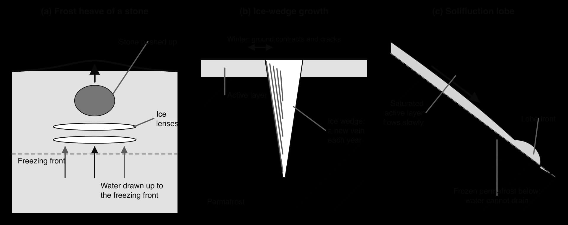
Frost heave lifts the ground surface when ice lenses grow in fine-grained soil. As the freezing front moves down in winter, water is drawn up through the soil by capillary action to the growing ice, so the lenses thicken and push the soil above upwards, sometimes by 30 cm or more. Stones are heaved upwards too. A stone conducts cold faster than the soil around it, so ice forms beneath it first and lifts it; when the ground thaws, fine soil slumps into the space beneath the stone before it can settle, so over many cycles stones move up to the surface.
Solifluction is the slow downslope flow of saturated soil. In summer the active layer thaws, but the permafrost below stays frozen and impermeable, so meltwater cannot drain away. The waterlogged soil loses strength and flows slowly downhill, even on gentle slopes, forming tongue-shaped lobes and terraces with steep fronts. The periglacial form of this mass movement, over frozen ground, is sometimes called gelifluction.
Patterned ground is a geometric arrangement of stones, soil and vegetation on the surface of periglacial areas. On flat ground, frost heave pushes stones up and outwards from domes of fine soil, so stones collect in circles and polygons from a few centimetres to several metres across. On slopes the circles are pulled downhill by solifluction into stripes.
Larger polygons, tens of metres across, form by thermal contraction. In very cold winters the frozen ground shrinks and cracks; in spring meltwater runs into the cracks and freezes in the permafrost. Each year the crack reopens in the same place and adds another vein of ice, so a wedge of ice up to 3–4 m wide at the surface grows downwards. The network of ice wedges forms ice-wedge polygons, common on the coastal plains of Alaska, Siberia and Svalbard.
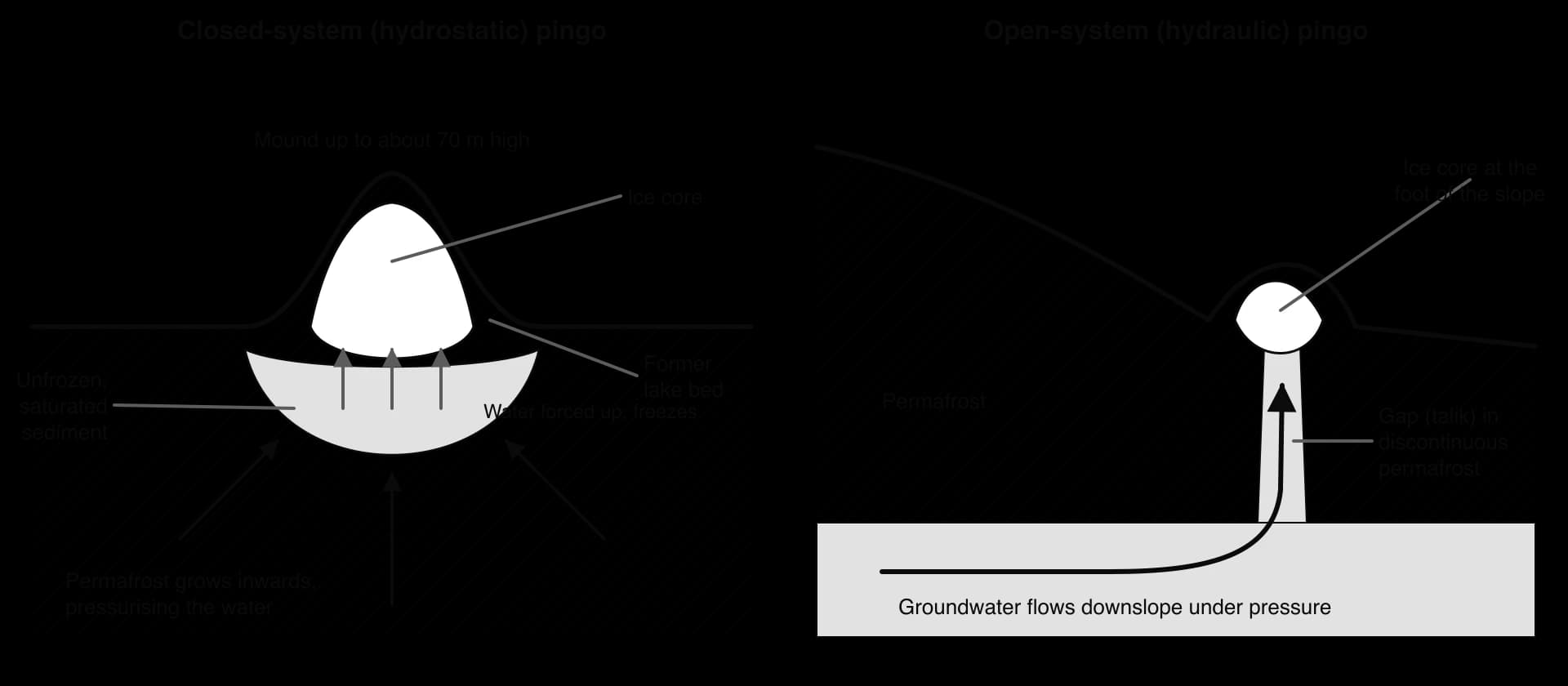
A pingo is an ice-cored hill, 3–70 m high and 30–1,000 m across, found only in permafrost areas. There are estimated to be more than 11,000 pingos on Earth, and the Tuktoyaktuk Peninsula in the Mackenzie Delta of Canada has about 1,350, roughly a quarter of them. Pingos form in two ways.
Closed-system (hydrostatic) pingos form in the beds of drained lakes in continuous permafrost. While the lake existed, a talik lay beneath it. When the lake drains or fills with sediment, permafrost grows inwards into the talik from below and from the sides. The trapped water is put under pressure and forced upwards, where it freezes into a growing lens of ice that domes the ground above. This is the Mackenzie Delta type.
Open-system (hydraulic) pingos form where groundwater flowing downslope beneath or within discontinuous permafrost is forced up through a gap, often at the foot of a slope. The water freezes near the surface into an ice core, and because the supply is continuous the pingo can keep growing. They are common in East Greenland and Svalbard.
Ibyuk Pingo, in the Pingo Canadian Landmark 5 km west of Tuktoyaktuk, is Canada’s highest at 49 m. It is at least 1,000 years old and is still growing by about 2 cm a year. When the ice core of a pingo melts, the mound collapses into a crater-like hollow with a rampart around it, often filled by a pond.
Thermokarst is irregular, hummocky ground with hollows and lakes, formed when ice-rich permafrost thaws and the ground subsides. Because ground ice can make up a large share of the volume of frozen soil, thawing causes the surface to collapse. Thaw lakes then absorb more of the Sun’s heat than the surrounding ground and thaw the permafrost further, a positive feedback.
The Batagaika crater in the Sakha Republic of Russia is the largest known permafrost crater, a gash about 1 km long and up to 100 m deep. The ground began to sink in the 1960s after the forest was cleared, exposing the permafrost to summer heat; by 2016 its headwall was retreating by more than 10 m, and up to 30 m, a year. Thaw of this kind is increasingly triggered by climate change and by heat from buildings, pipelines and roads, which makes it a hazard for settlement and infrastructure.
Weathering is the breakdown of rock in place, without movement. In deserts it is dominated by physical weathering, because heat and salts are abundant while water, the main agent of chemical change, is scarce. Bare rock surfaces, exposed to the Sun and to large daily temperature changes, are attacked directly.
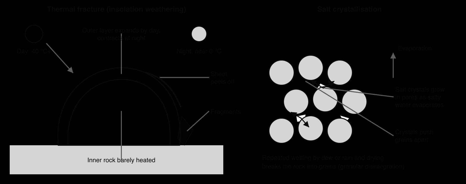
Thermal fracture results from the large diurnal temperature range of deserts. By day, rock surfaces can heat to well above the air temperature and expand; at night they cool and contract. Rock conducts heat poorly, so the outer few centimetres heat and cool much more than the interior, and different minerals expand by different amounts. Repeated stress weakens the rock until thin sheets peel off (exfoliation) or grains loosen (granular disintegration).
The importance of heat alone is debated. Early 20th-century laboratory experiments that heated and cooled rock many times found little effect when the rock was kept dry, and geologists long discounted the process. More recent field studies suggest thermal stress does weaken rock over long periods, especially when combined with small amounts of moisture from dew, so most geomorphologists now see it as one of several interacting processes rather than acting alone.
Salt crystallisation is probably the most effective weathering process in deserts and on desert coasts. Salty water from dew, rare rain or groundwater seeps into pores and cracks. As it evaporates in the heat, salt crystals grow and push the surrounding grains apart; heated crystals also expand. Repeated many times, this crumbles porous rocks such as sandstone and limestone into grains and hollows out cavities and honeycomb patterns.
In high deserts and cold-winter deserts, such as the Andean altiplano, the Gobi or the Tibetan Plateau, freeze-thaw also operates at night when temperatures fall below zero, wherever a little moisture is present.
Chemical weathering changes the minerals in rock. It needs water, so it is slow in deserts, but it is not absent: dew, occasional rain and groundwater supply enough moisture for several processes. In hydration, minerals absorb water and swell; in oxidation, iron in the rock reacts with oxygen, giving many desert rocks and sands their red and orange colours, as in the dunes of Sossusvlei in Namibia; and in solution, soluble minerals such as salts and gypsum dissolve.
A distinctive product is desert varnish, a dark coating about one micrometre thick of clay and iron and manganese oxides that builds up over thousands of years on exposed rock surfaces. Chemical weathering is much slower in deserts than in humid tropical climates, because it depends on water and is speeded up by heat; physical weathering therefore dominates in hot arid areas.
Physical weathering | Chemical weathering | |
|---|---|---|
What changes | Size and shape of fragments | The minerals themselves |
Main desert processes | Thermal fracture, salt crystallisation, freeze-thaw at night | Hydration, oxidation, solution |
Controlled by | Diurnal temperature range, salts, occasional moisture | Moisture (dew, rain), temperature |
Importance in hot deserts | Dominant | Slow but significant over long periods |
Evidence | Exfoliation sheets, angular debris, crumbling sandstone | Red iron staining, desert varnish, salt crusts |
Wind is more effective in deserts than elsewhere because there is little vegetation or soil moisture to hold particles down. Its power is limited, however: it can lift only fine particles, and it can carry sand only close to the ground.
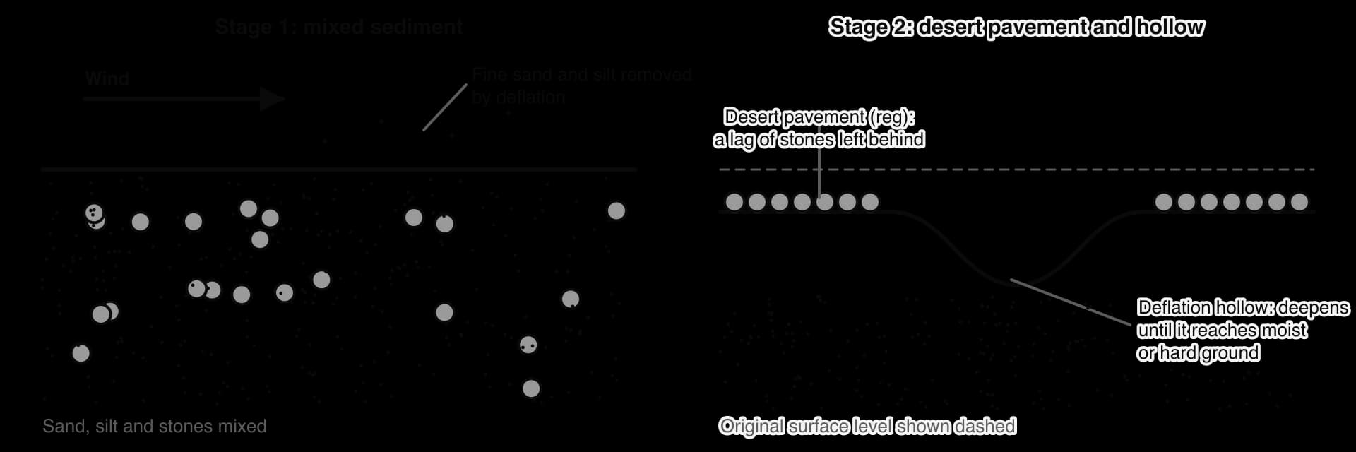
Deflation is the removal of loose, fine material, sand, silt and clay, by the wind. Over time it lowers the land surface. Where it scoops out a depression, a deflation hollow forms, which deepens until it reaches moist ground or a resistant layer that the wind cannot remove. The Qattara Depression in Egypt’s Western Desert, whose lowest point lies about 133 m below sea level, is thought to have formed mainly by salt weathering and deflation, which slowed where the floor reached moist ground near the water table.
Where the surface contains a mixture of particle sizes, deflation removes the fines and leaves the larger stones behind. These settle together into a tightly packed surface layer called a desert pavement, or reg, which protects the sediment beneath from further deflation.
Wind abrasion is sand-blasting: saltating sand grains carried by the wind strike and wear away rock surfaces. Because sand grains rarely rise far above the ground, abrasion is concentrated within about the lowest metre. Rocks shaped and polished by wind-blown sand are called ventifacts; the Árbol de Piedra (“stone tree”) on the Bolivian altiplano is a ventifact whose thin stem was cut by wind-blown sand in soft sandstone.
Larger streamlined ridges carved parallel to the wind from alternating hard and soft rock are yardangs. Zeugen are tabular ridges where horizontal bands of hard rock lie over softer rock: abrasion and weathering cut down through joints in the hard cap and undercut the soft layer beneath, leaving flat-topped blocks separated by furrows.
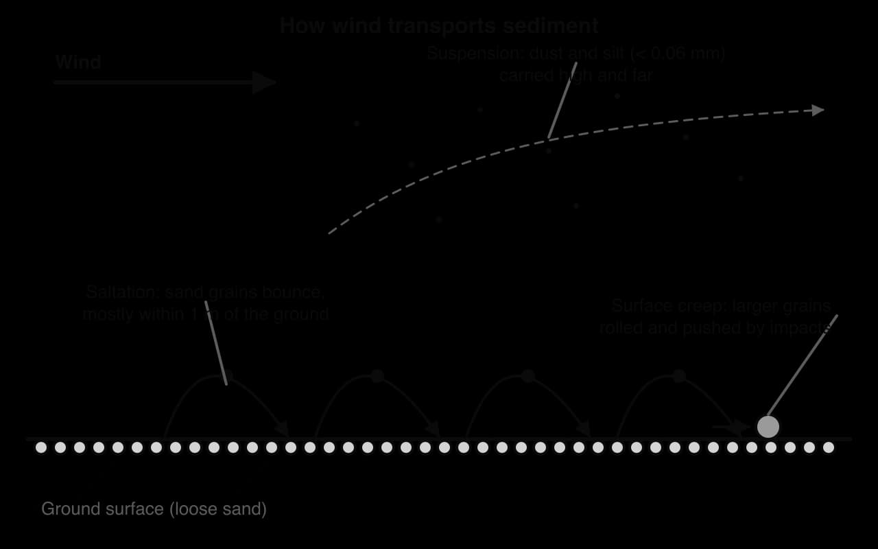
Wind moves particles in three ways, depending on their size and the wind speed. Fine silt and clay, smaller than about 0.06 mm, are lifted into suspension and carried high into the atmosphere and over great distances: dust from the Sahara regularly reaches the Caribbean, the south-eastern USA and the Amazon basin, where it is a main source of phosphorus for the rainforest soils. Sand grains move by saltation, bouncing along in low arcs and knocking other grains into motion. Larger grains too heavy to lift are rolled and pushed by the impacts of saltating grains, called surface creep.
Particles start to move only above a threshold wind speed, which rises with particle size, as on the Hjulström curve for rivers. Very fine particles also need a strong wind, because they lie in a smooth layer close to the ground and stick together; this is why fine dust is lifted mainly in storms.
 YouTube
The wind drops its load where it slows down, for example behind an obstacle, in a hollow or where it meets air moving in another direction. Sand is deposited as dunes, which cover large areas called sand seas or ergs, such as the Rub’ al Khali of Arabia. Fine silt carried in suspension can travel beyond the desert and settle as loess, a yellowish, fertile, wind-blown silt. The Loess Plateau of north-central China, south-east of the Gobi, is formed of loess blown from the deserts of central Asia during the Quaternary.
Despite low rainfall, running water does much of the erosion in deserts. Rain falls in intense storms on bare ground with little vegetation or soil to absorb it, so it runs off quickly as sheet floods over wide surfaces or as flash floods in channels. In a few hours such floods move more sediment than the wind does in years.
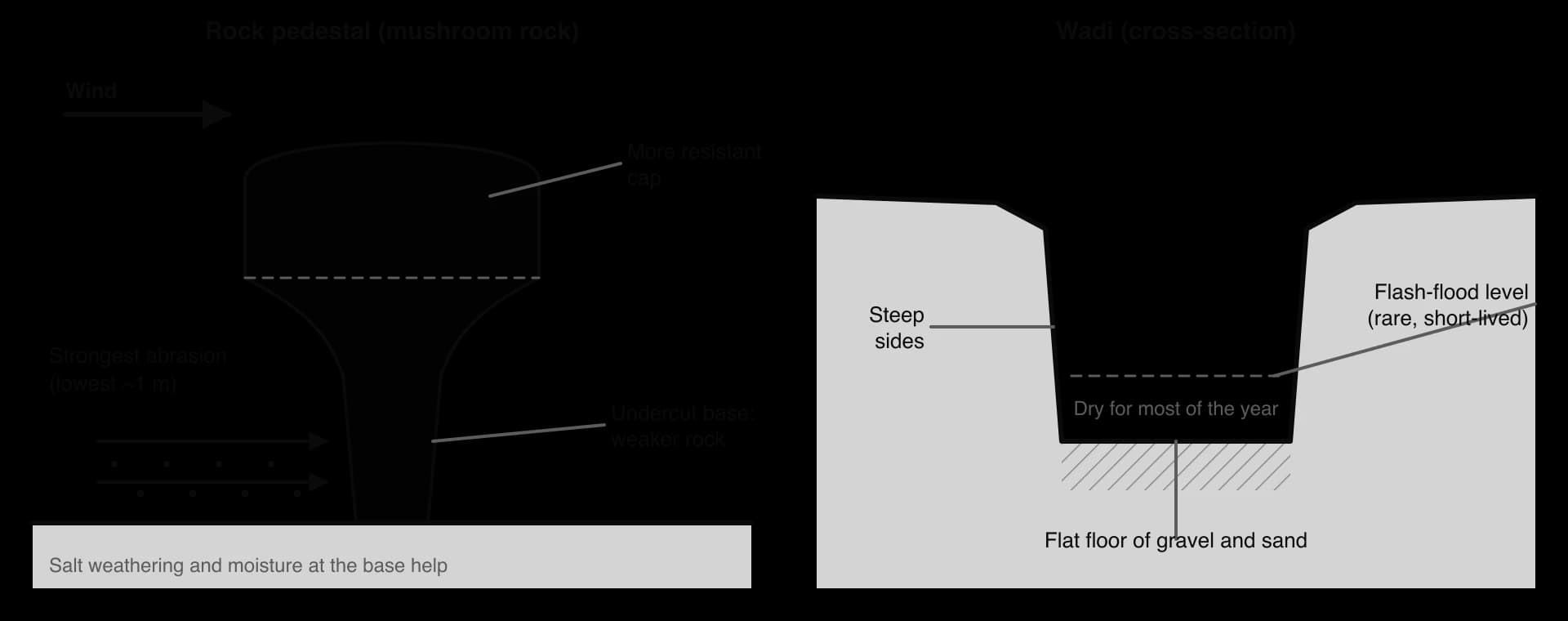
A wadi is a dry valley in a desert, usually steep-sided and flat-floored, that carries water only after heavy rain. Flash floods cut its sides, and its floor is covered by gravel and sand dropped as each flood ends. Some wadis are partly relict, cut when the climate was wetter. Wadis matter to people as routes, as sources of groundwater and seasonal grazing, and as hazards: settlements and roads on wadi floors can be swept away by flash floods.
Wadi Rum in southern Jordan, a UNESCO World Heritage Site since 2011 and the largest wadi in Jordan at 720 km², is a broad valley system cut into sandstone and granite, flanked by steep mountains (jebels).
Where a wadi leaves a mountain range and reaches a plain, the flood suddenly spreads out, slows and loses energy, so it drops its load in an alluvial fan. Coarse gravel and boulders are deposited near the apex, at the mouth of the wadi, and finer sand and silt towards the edges. Where several fans along a mountain front merge, they form a continuous gentle slope called a bajada. Gently sloping rock surfaces at the foot of desert mountains, eroded by sheet floods and weathering, are called pediments.
Water that reaches the centre of an enclosed basin, with no outlet to the sea, collects in a shallow temporary lake. When it evaporates, it leaves fine silt, clay and salts on a flat surface called a playa, salt pan or salt flat. Sossusvlei in the Namib Desert is such a pan, where the ephemeral Tsauchab River ends among dunes.

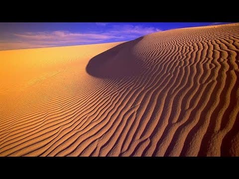
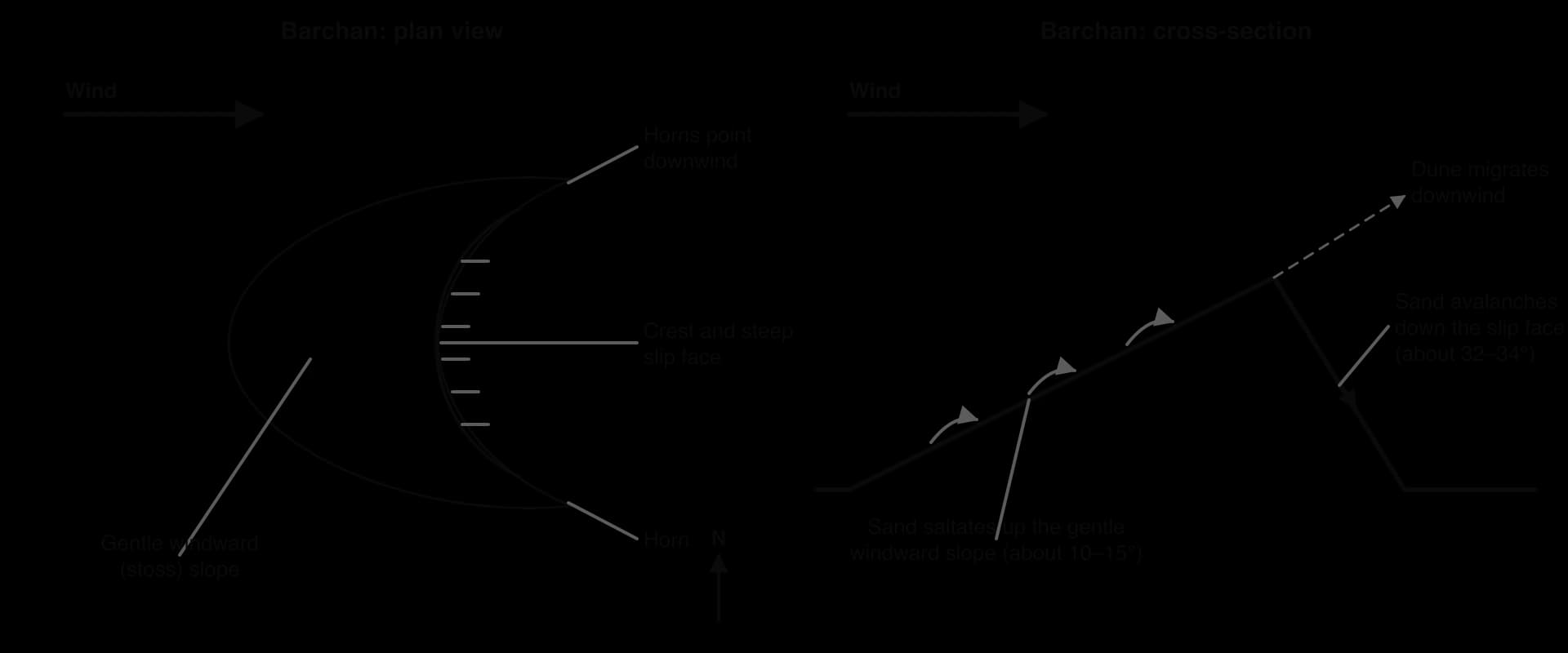
A sand dune is a mound or ridge of wind-blown sand. Wind pushes sand grains up the gentle windward (stoss) slope by saltation and creep. Beyond the crest the airflow separates from the surface and slows, so sand is deposited and piles up until the leeward slope becomes too steep; then it slides and avalanches down the slip face, which stands at the angle of repose of dry sand, about 32–34°. Because sand is moved from the windward side to the lee side, the whole dune migrates downwind.
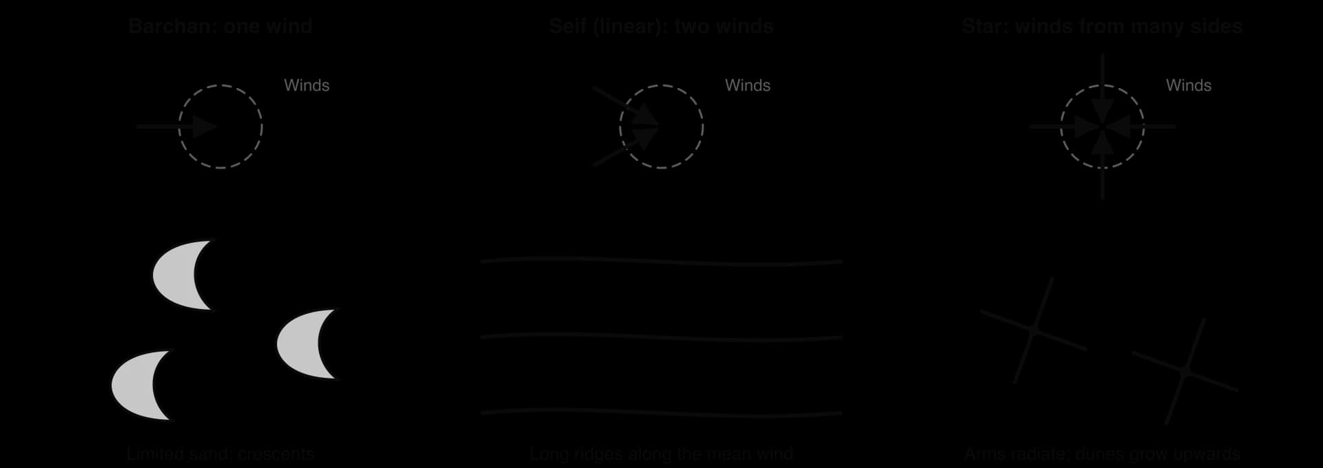
The shape of a dune depends on the supply of sand and on the wind regime. A barchan is crescent-shaped, with its horns pointing downwind; it forms where sand is limited and the wind blows mainly from one direction. Small barchans move fastest: some dunes in Ningxia, China, moved more than 100 m a year in the 1950s, and similar speeds have been recorded in Egypt’s Western Desert.
A seif dune, or linear dune, is a long, sharp-crested ridge lying parallel to the average direction of two winds that blow from different directions in different seasons. Linear dunes can reach 300 m high and 300 km long; in the Rub’ al Khali they stretch for almost 200 km. Where sand is abundant and the wind blows from one direction, dunes merge into transverse ridges at right angles to the wind.
A star dune has three or more arms radiating from a high central peak and forms where the wind blows from several directions. Because the arms are rebuilt by each wind, star dunes grow upwards rather than moving far. They are the tallest dunes: in the Badain Jaran Desert of China some reach about 500 m, and around Sossusvlei in the Namib many exceed 200 m, the highest, nicknamed Big Daddy, being about 325 m.
Moving dunes can bury roads, railways, farmland and settlements on desert margins. Engineers stabilise them with fences, vegetation and straw grids, but moving sand remains a cost for oases and transport routes from Mauritania, where dunes encroach on the edges of the capital, Nouakchott, to northern China.
A rock pedestal, or mushroom rock, is a rock with a narrow base and a wider top. It forms where wind abrasion is strongest near the ground: saltating sand undercuts an isolated outcrop, while its upper part, above the reach of most sand, is worn more slowly. The effect is greatest where a weaker layer lies beneath a more resistant one. Salt weathering and moisture at the base, where dew and rain collect, help to weaken it. The chalk formations of the White Desert in Egypt’s Farafra Depression, shaped by wind and sand, include many such forms.
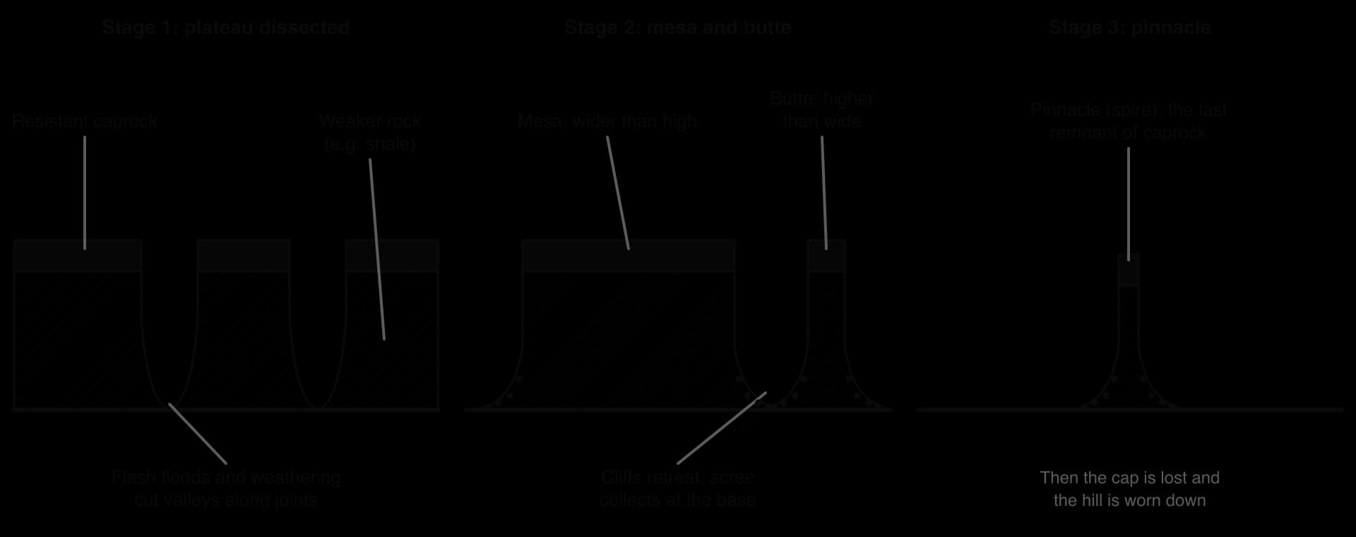
Mesas and buttes form in areas of horizontal sedimentary rock where a resistant layer (the caprock), such as sandstone, conglomerate or a lava flow, lies on weaker rock such as shale. They form step by step:
A plateau is dissected: flash floods and weathering cut valleys down through the caprock along joints and faults.
Scarps retreat: once the weaker rock beneath is exposed, it is weathered and eroded quickly, undercutting the caprock, which collapses in blocks; the cliffs retreat while keeping their steep faces, with scree at their foot.
A mesa remains: a large, flat-topped hill, wider than it is high, protected by its caprock.
A butte remains: as the mesa is worn back, a smaller remnant forms, higher than it is wide.
A pinnacle or spire is the last narrow remnant before the cap is lost and the hill is worn down.
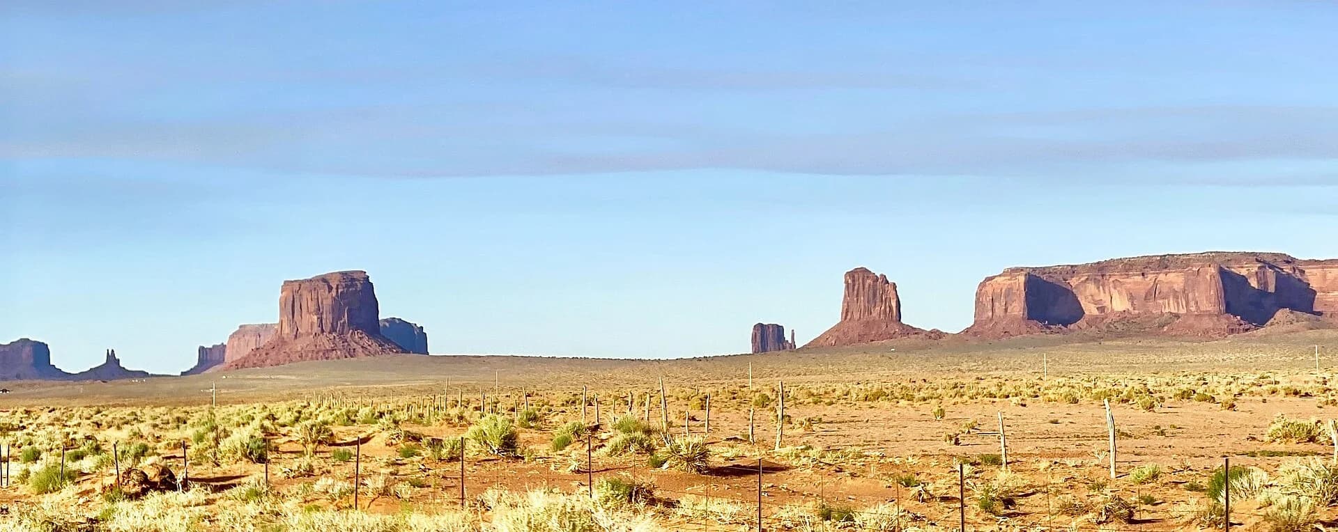
Monument Valley, on the Arizona–Utah border within the Navajo Nation, is the classic example. Its sandstone buttes rise up to 300 m above the valley floor and show three main layers: Organ Rock Shale at the base, de Chelly Sandstone in the cliffs, and a cap of the Moenkopi Formation and Shinarump Conglomerate. Its named landforms range from mesas such as Hunts Mesa to buttes such as the Mittens and the slender Totem Pole, a highly eroded remnant.
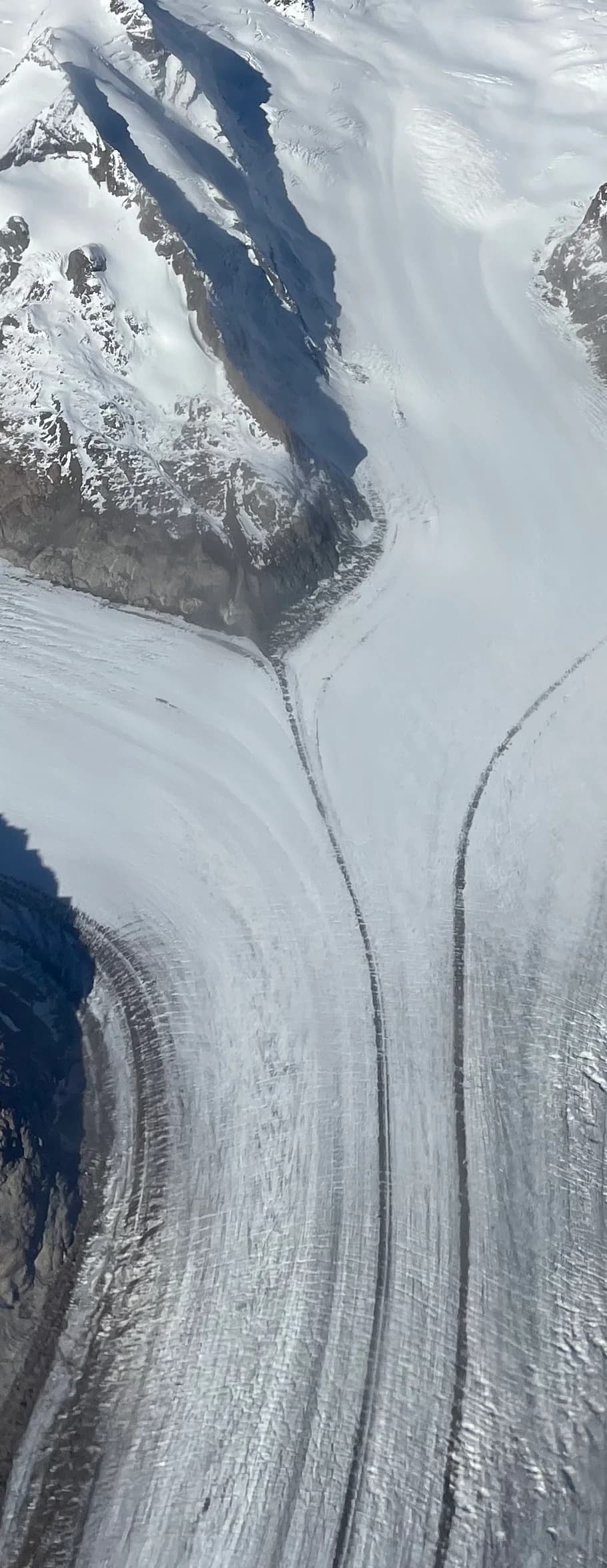
The Great Aletsch Glacier, in the Bernese Alps of the canton of Valais, is the largest glacier in the Alps: about 23 km long (2014), covering about 81.7 km² and holding 15.4 km³ of ice (2011). It lies in the Jungfrau-Aletsch Protected Area, a UNESCO World Heritage Site since 2001. The glacier shows almost every element of a glacial system and a valley glacier’s landforms, and one of the longest records of how a glacier responds to climate.
Four tributary firns, the Grosser Aletschfirn, the Jungfraufirn, the Ewigschneefäld and the Grüneggfirn, begin at around 3,800 m and converge at Konkordiaplatz, where the ice is up to 905 m thick. Below Konkordiaplatz the glacier is about 1.5 km wide and moves south-east at about 180 m a year towards the Rhône valley. It is a warm-based glacier, so it moves by basal sliding as well as internal deformation and erodes its bed actively. Meltwater from the snout forms the River Massa, which flows through the Massa gorge and is used for hydroelectric power before reaching the Rhône near Brig.
Where the tributary glaciers merge, their lateral moraines combine into two dark medial moraines, the Kranzberg moraine in the west and the Trugberg moraine in the east, which run in parallel bands down almost the whole length of the glacier to the snout.
The lower glacier is largely covered by debris from its lateral and medial moraines. The glacier occupies a deep glacial trough, and on its eastern side, near Bettmeralp, the Märjelensee at 2,301 m is an ice-marginal lake dammed by the glacier. The firn basins are enclosed by high, steep-sided peaks and ridges, from the Jungfrau and the Mönch in the north to the Aletschhorn (4,193 m) in the west.
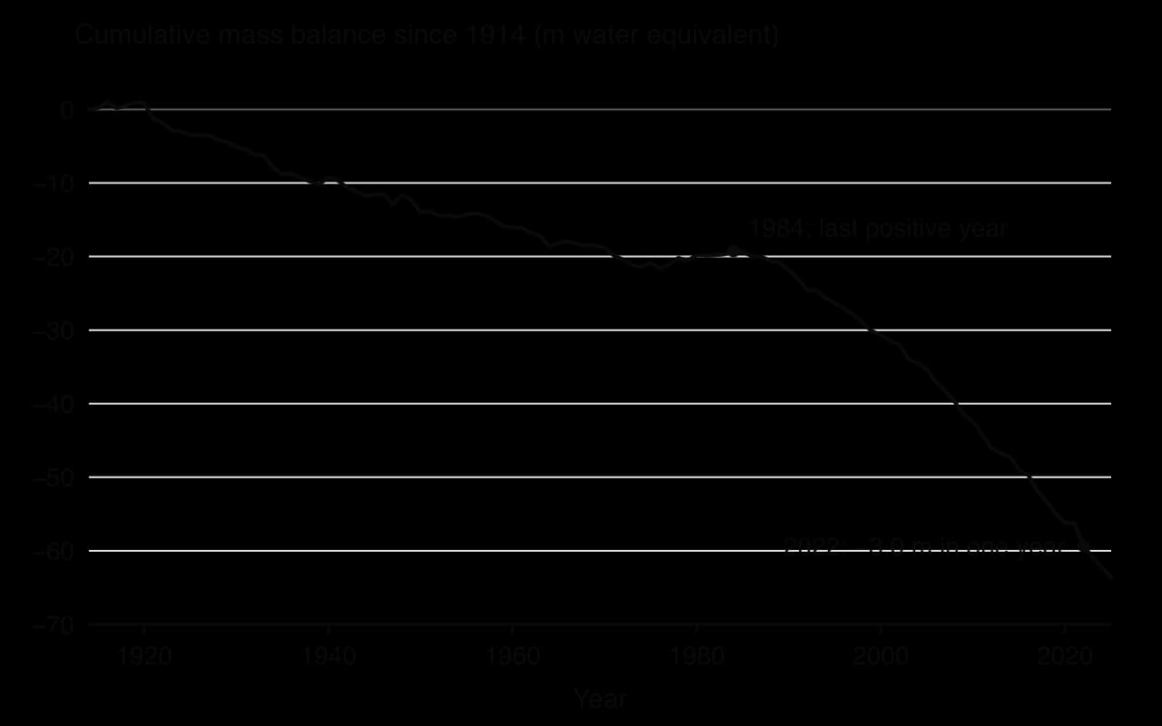
The GLAMOS monitoring network has a continuous mass balance record for the Aletsch from 1915 to 2025. Its cumulative balance fell to −63.7 m of water equivalent over 111 years. The mean annual balance was about −0.30 m w.e. from 1915 to 1980 but −1.32 m w.e. from 2001 to 2025, more than four times faster, and the last year with a positive balance was 1984. In 2022 the glacier lost 3.0 m w.e., its most negative year on record, when the equilibrium line rose to 3,605 m and only 11% of its area remained in the zone of accumulation.
The snout has retreated accordingly. GLAMOS measurements give a total length loss of 3,387 m over the measured intervals since 1870, 989 m of it between 2000 and 2024, with a record retreat of 114.6 m in 2005–06.
The glacier’s mouth reached the site of today’s Gibidum reservoir in the 19th century, more than 4 km below its present snout. Because it is so large, the Aletsch responds more slowly to climate than small glaciers: it has lost about 20% of its mass since 1850, while smaller Swiss glaciers have lost up to half. Even so, it is projected to keep only about a tenth of its 2018 ice mass by 2100.
Indicator | Value | What it shows |
|---|---|---|
Length (2014) | About 23 km | Largest glacier in the Alps |
Maximum thickness | 905 m at Konkordiaplatz | Deep trough eroded by thick ice |
Velocity below Konkordiaplatz | About 180 m a year | Warm-based: sliding and deformation |
Cumulative mass balance 1915–2025 | −63.7 m w.e. | Long-term negative balance |
Mean annual balance | −0.30 m w.e. (1915–1980); −1.32 m w.e. (2001–2025) | Loss has accelerated |
Length change 1870–2024 | −3,387 m | Snout retreat follows mass loss |
Equilibrium line, 2022 | 3,605 m; accumulation area 11% | An extreme melt year |
The case shows process at work at every scale: the system’s inputs and outputs, the flow that carries debris into moraines, and the change in mass balance that drives retreat. It also shows place: the Aletsch’s great size, thickness and altitude make it slower to respond than small Alpine glaciers. The retreat raises questions of possibility: hydroelectric schemes, tourism at Riederalp and Bettmeralp, and downstream water supplies in the Rhône valley all depend on ice that is projected largely to disappear this century.
Explain why the Aletsch Glacier continues to move south-east at about 180 m a year even though its snout is retreating.
Using the mass balance data, describe how the rate of loss changed after the 1980s.
Suggest why the Aletsch has lost a smaller share of its mass since 1850 than smaller Swiss glaciers.
Sources: GLAMOS, Swiss Glacier Mass Balance and Swiss Glacier Length Change, release 2025 (doi:10.18750/massbalance.2025.r2025; doi:10.18750/lengthchange.2025.r2025); Wikipedia, “Aletsch Glacier”, accessed 2026.
Questions on physical processes and landscapes usually give a diagram, photograph, map extract or data table and ask you to identify a landform, read a value, and explain how processes form landforms. Extended questions ask you to examine the processes behind a set of landforms or evaluate the relative importance of different agents.
The structured question uses real data for the Great Aletsch Glacier.
Year | 2019 | 2020 | 2021 | 2022 | 2023 | 2024 | 2025 |
|---|---|---|---|---|---|---|---|
Annual mass balance (mm w.e.) | −1,721 | −1,165 | −114 | −3,041 | −1,576 | −1,311 | −1,475 |
Equilibrium-line altitude (m) | 3,175 | 3,105 | 2,965 | 3,605 | 3,235 | 3,245 | 3,185 |
Sources: GLAMOS, Swiss Glacier Mass Balance, release 2025.
Extended answers are marked against the 10-mark markband. The top band needs a well-evidenced examination of all parts of the question, with a conclusion grounded in geographical concepts and perspectives.
A glacier is an open system: snow is compacted into firn and ice in the zone of accumulation, flows past the equilibrium line and is lost by ablation; its mass balance controls whether the snout advances or retreats, while the ice always flows forward.
Warm-based glaciers slide on meltwater and erode strongly; cold-based glaciers are frozen to their beds, move by internal deformation and erode little.
Glaciers erode by plucking and abrasion, carry debris on, within and beneath the ice, and deposit unsorted till directly and sorted outwash by meltwater.
Cirques form by snow accumulation, rotational movement, plucking and abrasion; arêtes and pyramidal peaks form where cirques erode back towards each other; troughs with truncated spurs, hanging valleys and ribbon lakes form when glaciers reshape river valleys.
Lateral, medial, terminal and recessional moraines are ridges of till named by position; erratics record the direction and extent of former ice.
Periglacial areas have continuous or discontinuous permafrost beneath an active layer; freeze-thaw, frost heave and solifluction produce scree, patterned ground and solifluction lobes, while pingos and thermokarst form as ground ice grows or thaws.
In hot deserts, physical weathering by thermal fracture and salt crystallisation dominates; wind erodes by deflation and abrasion, transports by suspension, saltation and creep and deposits dunes and loess; water, in flash floods, cuts wadis and builds alluvial fans and playas.
Dune shape depends on sand supply and wind regime (barchan, seif, star); rock pedestals form by abrasion near the ground; mesas and buttes form as a caprock protects weaker rock while scarps retreat.
I can draw and annotate a glacier system diagram and explain mass balance, advance and retreat.
I can distinguish warm-based and cold-based glaciers and explain how each moves.
I can explain plucking, abrasion, transport and the difference between till and outwash.
I can explain the formation of a cirque, arête, pyramidal peak, glacial trough, ribbon lake, moraines and erratics with named examples.
I can explain freeze-thaw, frost heave and solifluction, and the formation of patterned ground, pingos and thermokarst.
I can explain physical and chemical weathering in deserts and erosion, transport and deposition by wind and water.
I can explain the formation of dunes, wadis, rock pedestals, mesas and buttes with named examples.
I can construct and interpret a glacier mass balance graph and identify landforms from maps and photographs.
Glacial troughs (eg Nant Ffrancon, Wales; Lauterbrunnen valley, Switzerland) are widened and deepened by abrasion along their floors and sides, while plucking removes jointed rock, truncating spurs; overdeepened rock basins hold ribbon lakes (eg Wastwater, about 79 m deep).
The balance between the processes varies with rock type: massive, poorly jointed granite (eg parts of Yosemite) resists plucking and shows abrasion surfaces, whereas jointed rocks are rapidly quarried.
Good answers may be well structured (AO4) and may additionally offer a critical evaluation (AO3) which recognizes that plucking and abrasion operate together: plucking supplies the debris that makes abrasion effective, and abrasion can open up joints that plucking then exploits. Another approach might be to argue that the relative importance varies by landform, by position on the landform (stoss versus lee, back wall versus floor) and by place (geology, ice thickness, basal thermal regime). Some answers may question whether either process dominates at all in cold-based glaciers, where erosion is minimal, or note that freeze-thaw on exposed rock above the ice is needed to explain the sharpness of arêtes and horns.
For 5–6 marks, expect some weakly-evidenced outlining of how plucking and/or abrasion form one or more glacial erosional landforms.
For 7–8 marks, expect a structured account which includes:
either well-evidenced explanation of how both plucking and abrasion contribute to the formation of two or more landforms in named places
or a discursive conclusion (or ongoing evaluation) of their relative importance, grounded in geographical concepts and/or perspectives.
For 9–10 marks, expect both of these traits.
NB. Do not expect perfect balance between the two processes. Maximum [5] if only one process is discussed.
Marks | Level descriptor |
|---|---|
0 | The response does not reach a standard described by the descriptors below. |
1–2 | Too brief, lists unconnected information, not focused on the question and lacks structure. Knowledge is very general, with large gaps or errors; examples or case studies are missing or only listed. No analysis; terminology is missing or used incorrectly. |
3–4 | Too general, lacks detail, not focused on the question and largely unstructured. Outlines examples, statistics and facts, both relevant and irrelevant, with links to the question only listed. Basic terminology is used, with errors or inconsistently. No critical evaluation of evidence; any conclusion is irrelevant. |
5–6 | Partially addresses the question, with a narrow argument, an unsubstantiated conclusion and limited evaluation. Describes relevant supporting evidence (examples, case studies) and outlines links to the question. The argument repeats one point or covers only part of the question. Other perspectives, or strengths and weaknesses of evidence, are listed. |
7–8 | Addresses the whole question; the analysis is evaluated and the conclusion is relevant but lacks balance. Relevant evidence is described correctly and covers all the main points. The argument is clear but one-sided or unbalanced. Complex terminology is used correctly but not consistently. Other perspectives, or strengths and weaknesses of evidence, are described. |
9–10 | In-depth and specific to the question (topic and command term). Correct, relevant examples, statistics and detail are integrated and their link to the question explained. The argument is balanced, explaining complexity, exceptions and comparisons. Evaluation of evidence and perspectives is well developed, and the conclusion is balanced and aligned with the evidence. Logically structured and easy to follow. |
Examine the extent to which the landscapes of glaciated areas reflect whether their glaciers are warm-based or cold-based.
10 marks
Examine the importance of glacial transport in the formation of depositional landscape features, including moraines and erratics.
10 marks