Evaluate farming, mining and tourism in cold and arid environments, and examine how states, TNCs and Indigenous peoples hold different power to extract value, using the Salar de Atacama, Norilsk and tourism examples.
Each is in the Geography glossary, with every other term in the subject.
The international agreement, signed in 1959, that reserves Antarctica for peace and science, sets aside territorial claims and, through its 1991 Environmental Protocol, bans mineral extraction.
A soil of arid regions that is dry for most of the year, with little organic matter and often layers of calcium carbonate, gypsum or salts near the surface.
A cycle in which a place grows rapidly while a resource is profitable to extract and declines sharply when prices fall or the resource runs out.
A method of obtaining lithium and other dissolved salts by pumping mineral-rich groundwater from beneath a salt flat into shallow ponds, where evaporation concentrates it before processing.
An irrigation system in which a line of sprinklers mounted on wheeled towers rotates around a central water supply, watering a circular field.
Rights to own or use land that come from the traditions of a community, such as a village, clan or herding group, rather than from a title registered by the state.
Growing crops without irrigation in areas of low rainfall by conserving soil moisture, for example through fallowing, mulching and drought-tolerant crop varieties.
Distinguish between aridity and infertility, and explain why some dryland soils become highly productive when irrigated.
Describe traditional ways of farming in arid areas, including nomadic pastoralism, oasis farming, qanats and dry farming.
Evaluate modern irrigation in arid areas, including who has access to water and the risk of salinisation.
Explain how land ownership and land tenure affect farming in drylands, including large-scale land acquisitions.
Examine the human and physical opportunities and challenges of mineral extraction in cold environments, including inaccessibility, permafrost and resource nationalism.
Examine the opportunities and challenges of mineral extraction in arid environments, including inaccessibility and climatic and political factors.
Evaluate the opportunities and challenges of tourism in extreme environments, using detailed examples of local and global stakeholders.
Analyse the varying power of states, transnational corporations, Indigenous peoples and other stakeholders to extract economic value from extreme environments.
Extreme environments are difficult places to live, but they hold great economic value: farmland that becomes productive when water reaches it, some of the world’s largest reserves of metals and hydrocarbons, and landscapes that attract hundreds of thousands of tourists a year. Managing these environments means deciding who can extract that value, at what cost and for whose benefit.
The key concept of power runs through the whole topic. A state that owns the subsoil, a transnational corporation with the capital to build a mine, an Indigenous community that holds the land and a tourist who pays for a permit all have different abilities to shape what happens.
71 exam-style questions on this subtopic, written in the style of the IB papers. The first has its markscheme open. Counted on
To what extent is the development of thermokarst landscapes the result of human activity rather than natural processes?
10 marks
Marks should be allocated according to the markbands.
Thermokarst is the irregular, hummocky terrain of thaw lakes, depressions, slumps and collapsed ground that forms when ice-rich permafrost thaws and the ground subsides. Despite its name it has nothing to do with limestone karst. Thaw can be triggered by natural changes (climate variations, wildfire, lake expansion, river and coastal erosion) and by human activity (removing vegetation, heat from buildings and pipelines, roads, mining) as well as by human-induced global warming. Accept a broad interpretation of 'human activity' that includes both local disturbance and anthropogenic climate change.
Possible applied themes (AO2) demonstrating knowledge and understanding (AO1):
Thermokarst formed naturally in the past, eg widespread thaw lakes and alases in central Yakutia, Siberia, formed during warm periods of the Holocene; old drained lake basins are common across the Arctic lowlands.
Natural disturbances such as tundra fires remove the insulating organic layer, deepening the active layer and causing thaw; river and coastal erosion expose ice-rich banks, leading to retrogressive thaw slumps.
Local human disturbance: clearing vegetation, which removes insulation; heat from unraised buildings; roads and pipelines that alter drainage and snow cover. The Batagaika crater (Yakutia) began to develop after forest clearance in the 1960s and has expanded to more than 1 km in length.
Engineering responses show the role of heat: Yakutsk's buildings stand on piles, and the Trans-Alaska Pipeline is raised on supports with heat pipes over long sections to prevent thaw.
Anthropogenic climate change is warming the Arctic faster than the global average, raising permafrost temperatures and deepening the active layer; this is increasing thermokarst lakes, slumps and coastal collapse.
With a free account, Augment remembers where you stopped and what you have practiced.
A way of employing workers at remote mines in which they are flown to the site for a shift of one to several weeks, living in camps, then flown home for a rest period.
A seasonal road built across frozen lakes, rivers, sea ice or tundra in winter, usable only while the ice is thick enough to carry vehicles.
The inability of a soil to support healthy plant growth because it lacks nutrients, organic matter or a suitable structure, or contains harmful levels of salt or other toxins.
An organisation of tour companies, founded in 1991, that sets and enforces rules for safe and environmentally responsible private travel to Antarctica among its members.
The system of rules, set in law or by custom, that decides how land is owned, used, inherited and transferred, and by whom.
The purchase or long-term lease of large areas of land, typically thousands of hectares, by companies, investment funds or foreign governments, often for export farming; called a land grab by critics.
The removal of valuable solid minerals such as metal ores and diamonds, or of oil and natural gas, from the ground or the seabed by mining or drilling.
The transfer of a privately owned company or industry into ownership by the state, with or without compensation to its previous owners.
A way of life in which herders move their livestock between seasonal pastures and water sources instead of farming fixed fields, using mobility to cope with variable rainfall.
A fertile area in a desert where groundwater reaches or comes close to the surface, through springs, wells or channels, allowing permanent settlement and irrigated farming.
A method of surface mining in which ore is removed from a large, stepped excavation open to the sky after the overlying rock and soil have been stripped away.
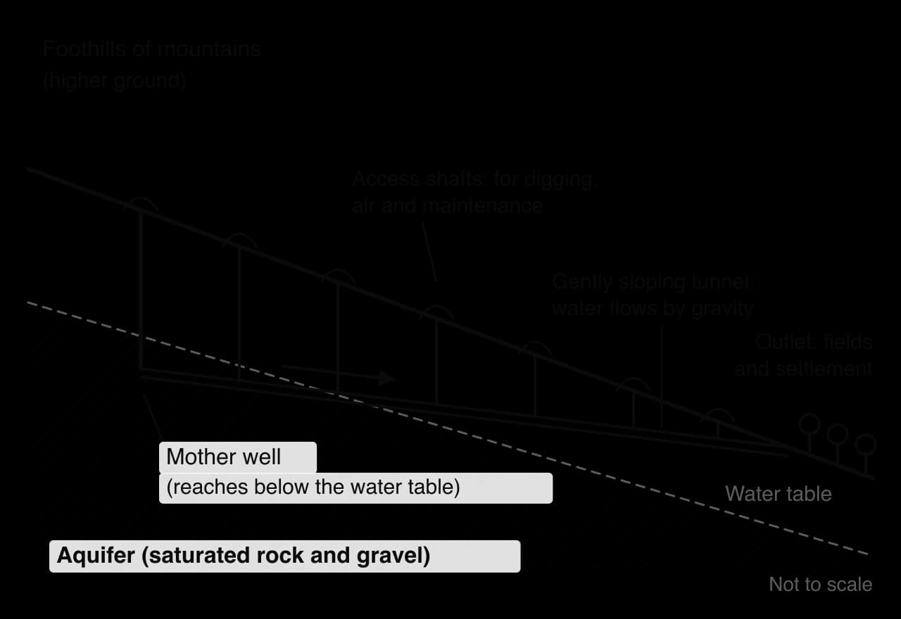
A gently sloping underground tunnel that carries groundwater by gravity from an aquifer in higher ground to the surface at a lower point, with vertical shafts for construction and maintenance.
The assertion by a state of greater control over the natural resources in its territory, through state companies, ownership limits, taxes, royalties or bans, so that more of the benefit stays in the country.
A payment made by a mining company to the owner of the mineral rights, usually the state, for each unit of resource extracted or as a share of its value or profit.
A sealed pipe containing a fluid that passively removes heat from the ground in winter, evaporating at its lower end and condensing at its finned upper end; used to keep permafrost frozen.
Drylands, where potential evaporation is far greater than precipitation, cover about 41% of the Earth’s land surface. Crops cannot grow without water in the root zone, so lack of water is the main limit on farming in a hot desert or a semi-arid environment. A lack of water is a climatic condition, however, and says nothing about whether the soil could support crops.
Aridity and infertility are separate problems with separate solutions. An arid soil can be fertile: once water is supplied, it may grow crops as well as any soil on Earth. An infertile soil stays unproductive however much water it receives, unless nutrients, organic matter or drainage are added as well.
Aridisols form where there is too little water to wash soluble minerals down through the profile. Weathering releases nutrients such as potassium, calcium and phosphorus, and because little rain falls they are not leached away, so many desert soils hold more plant nutrients than the leached soils of humid tropical forests. Their weaknesses are low organic matter, poor structure, and salts or hard calcrete layers near the surface.
River valleys in deserts add fertile alluvium deposited by floods: the Nile valley in Egypt has been farmed for over 5,000 years. The Imperial Valley in southern California receives about 74 mm of rain a year, yet Colorado River water delivered through the All-American Canal makes it one of the most productive farming regions in the United States, with crop sales of over US$1 billion a year.
People have farmed and herded in drylands for thousands of years using indigenous knowledge built up over generations. Each method manages the same two risks: too little water on average, and great rainfall variability from one year to the next.
Nomadic pastoralism turns mobility into risk management. Rain in drylands falls patchily, so grass grows in different places in different years. By moving with their herds, pastoralists such as the Tuareg of the central Sahara, the Fulani of the Sahel and the Maasai of Kenya and Tanzania use pasture where it has grown and let it recover once they move on. When land is fenced or herders are settled around boreholes, the system loses its mobility and overgrazing near settlements becomes likely, one cause of desertification.
An oasis forms where groundwater is near the surface, for example in a depression or along a fault. Oasis farmers use the space intensively by layered cropping: date palms provide shade and fruit, fruit trees grow beneath them, and vegetables or fodder grow at ground level, where the shade reduces evaporation. Siwa in Egypt’s Western Desert is an example.
A qanat begins with a mother well dug into an aquifer near the foot of a mountain. A tunnel is dug back towards it from an outlet lower down the slope, at a gradient just steep enough for water to flow. Because the water travels underground, little is lost to evaporation, and because it flows by gravity, no pumping is needed.
Qanats were developed in ancient Iran in the early first millennium BCE and spread across the Middle East, North Africa and Central Asia; Iran still had about 37,000 in use in 2015. Their main threat is pumping: boreholes lift water faster than a qanat delivers it and lower the water table until the qanat runs dry. In the Kurdistan region of Iraq, working karez fell from about 380 in 2004 to 116 in 2009 because of neglect, overpumping and drought.
Dry farming stores rain in the soil from one season to the next: a field is left fallow so that moisture builds up, weeds are removed, and mulch reduces evaporation. Water harvesting concentrates rain where crops grow: farmers in Burkina Faso dig zai pits, small manure-filled planting pits, and build stone lines along the contour to slow runoff. Yields are lower than with irrigation, but costs are low and no extra water is used.
Irrigation turns aridity into an opportunity: drylands have high sunshine, long growing seasons and, in many places, fertile soils. The question is who has access to water. Exotic rivers such as the Nile, Indus and Colorado rise in wetter mountains and cross deserts, but their flow sets an upper limit and upstream and downstream users compete for it. Renewable aquifers can supply water indefinitely if pumping does not exceed recharge. Fossil aquifers hold fossil water that accumulated thousands of years ago and is not replaced today, so pumping it is a form of mining.
Libya’s Great Man-Made River shows the scale of fossil-water use. Since 1984, over 1,300 wells have pumped water from the Nubian Sandstone Aquifer System beneath the Sahara, and 2,820 km of pipes carry up to 6.5 million m³ a day to the coastal cities and farms, about 70% of Libya’s fresh water. Estimates of how long the aquifer could last range from 60–100 years to about 1,000 years, depending on the rate of extraction.
Saudi Arabia’s wheat programme shows the risks. From the late 1970s the government offered interest-free loans, cheap energy and guaranteed prices that by the late 1980s were three times the world price. Centre-pivot irrigation spread across the desert, production rose from 1.4 million tonnes in 1983 to 3.5 million tonnes in 1989, and the country became the world’s sixth-largest wheat exporter in the early 1990s. The water came from non-renewable aquifers, and as water tables fell the programme was phased out: domestic wheat production ended in 2016, and Saudi investors turned to farmland abroad.
Centre-pivot irrigation produces the green circles visible on satellite images of Saudi Arabia, Egypt’s Western Desert and the Great Plains. Drip irrigation delivers water through plastic pipes with small emitters to each plant’s roots, so far less is lost. The emitter was developed in Israel, where the first experimental system was set up in 1959 and the company Netafim was founded with Kibbutz Hatzerim in the Negev in 1964.
Fertigation tackles infertility and aridity together: nutrients arrive in small doses with the water, so less fertiliser is wasted or washed into groundwater. With drip irrigation it lets Israeli farmers grow vegetables, fruit and flowers for export in the Negev and the Arava valley.
Feature | Traditional dryland farming | Modern irrigated farming |
|---|---|---|
Examples | Nomadic pastoralism (Fulani, Tuareg); oasis gardens (Siwa); qanats (Iran); zai pits (Burkina Faso) | Centre-pivot wheat (Saudi Arabia to 2016); drip irrigation and fertigation (Israel); canals (Imperial Valley) |
Water source | Rain, runoff, springs, shallow groundwater moved by gravity | Dams and canals, deep boreholes, fossil aquifers |
Energy and capital | Low: human and animal labour, local materials | High: pumps, pipes, sensors, machinery, fertiliser |
Yields and markets | Low but reliable; subsistence and local markets | High; national and export markets |
Main risks | Drought, loss of grazing land, insecurity | Falling water tables, salinisation, debt, dependence on subsidies |
Who benefits | Households and communities with customary rights | Landowners, agribusiness and governments that can pay for water and technology |
The comparison shows a trade-off between productivity and resilience. Modern systems feed far more people per hectare but depend on capital, energy and water that may not last, and their benefits go mainly to those who can pay. Traditional systems are less productive but cheaper and more robust.
Salinisation, the build-up of salts in soil, happens in irrigated drylands in two linked ways. Irrigation water contains some dissolved salt, which stays behind when the water evaporates. When more water is applied than crops use, the water table rises, and once it is close to the surface capillary action draws salty groundwater upward, where it evaporates and leaves a white crust. Yields fall, and badly affected land is abandoned.
The risk is greater in arid areas because evaporation is intense and rain rarely flushes salts away. Farmers manage it by applying less water (drip irrigation), occasionally leaching salts below the root zone, installing drains that lower the water table, and growing salt-tolerant crops such as barley and date palms. Drainage water must go somewhere: California’s Salton Sea, which receives farm runoff from the Imperial Valley, suffered fish and bird die-offs in the 1980s and now produces toxic dust from its drying bed.
Who owns land, who may use it and for how long are as important as water in deciding who can farm a dryland, and they are decided by laws and customs rather than by the physical environment.
Land tenure takes several forms in drylands. Private titles are common in irrigated farmland in the United States and Israel, and in many countries all untitled land legally belongs to the state. In much of the Sahel and East Africa, most rural land is held under customary systems.
Customary land rights often give several groups overlapping rights to the same land: a village may cultivate a valley floor in the rainy season while herders graze crop stubble in the dry season. These arrangements are rarely written down, so when a government grants a lease to an investor, the group without a formal title usually loses.
Large-scale land acquisitions increased sharply after the 2007–08 food price crisis, when food-importing countries such as the Gulf states, which import about 60% of their food, tried to secure supplies by farming abroad. The Land Matrix database recorded deals covering 49 million hectares by January 2013. Ethiopia leased large areas of the lowland Gambella region to foreign investors from about 2008, at rents as low as about US$10 per hectare a year. Supporters expected roads, jobs and irrigation; critics pointed out that much of the land was used by pastoralists and shifting cultivators under customary rights, who were often excluded from negotiations.
Pastoral rights are the most easily lost. Herders’ claims to seasonal grazing and to the corridors that link it rarely appear on any map, so when governments enclose rangeland for ranches, irrigation schemes or conservation, or settle herders around boreholes and schools, mobility is lost. In Ethiopia’s lowlands the government’s “villagisation” programme from 2010 moved pastoral and shifting-cultivator households into new villages, partly to free land for commercial farms. In Sudan, large blocks of irrigable land along the Nile and in the east were leased to Gulf and Asian investors in the same period, often on land where farmers and herders held only customary rights.
Insecure tenure discourages investment: a farmer who may lose a field has little reason to build stone lines or plant trees that pay off over a decade. Women face particular barriers, because in many dryland societies they farm land that they hold only through husbands or fathers, and they are rarely consulted when land is leased to investors. Secure rights, from a title deed or a recognised customary system, are therefore one of the foundations of sustainable dryland farming.
No single approach suits every dryland. Large-scale irrigation and land investment produce more food and income but concentrate benefits among those with capital, and where they mine fossil water or cause salinisation they are not sustainable. The most successful strategies combine efficient irrigation where water is renewable with secure land rights for existing users and support for pastoralism on land too dry to cultivate.
Mineral extraction in the Arctic and in high mountains is expensive and risky, yet companies and governments invest billions of dollars in it, for three reasons.
Large reserves. In 2008 the United States Geological Survey (USGS) estimated that the area north of the Arctic Circle holds about 90 billion barrels of undiscovered, technically recoverable oil, about 13% of the world’s undiscovered oil, together with 1,669 trillion cubic feet of natural gas; about 84% probably lies offshore. Metals are as important: nickel and palladium at Norilsk, diamonds in Canada’s Northwest Territories, iron ore on Baffin Island, and rare earths and uranium in Greenland.
Rising demand and prices. Nickel and cobalt are used in batteries, palladium in catalytic converters and rare earths in wind turbines and electric motors. When prices are high, deposits that are too costly to mine in an inaccessible place become profitable; when prices fall, the same mines may close.
Better access and state strategies. Loss of sea ice lengthens the shipping season along the Northern Sea Route north of Russia, and governments see Arctic resources as a source of revenue and strategic influence: Greenland’s government regards mining as a route to greater economic independence from Denmark.
The challenges of cold-environment mining are both physical and human, and many are the features that make the environment extreme in the first place: inaccessibility, remoteness, cold, darkness and frozen ground.
Extreme cold makes steel brittle, thickens lubricants and drains batteries, so equipment must be specially built; darkness and a short summer limit construction; and sea ice restricts shipping, at the Mary River mine on Baffin Island to roughly August to October.
Permafrost is ground that stays at or below 0 °C for at least two years in a row; its upper part, the active layer, thaws every summer. Frozen ground is strong because ice binds the particles together, but much permafrost contains a large volume of ice. When it thaws, the ground loses its strength and subsides unevenly.
Mines, buildings, roads and pipelines bring heat to the ground. A heated building on the surface warms the soil beneath it, a pipeline carrying warm oil does the same along its length, and a dark road surface absorbs more sunlight than the tundra around it. As the permafrost thaws, foundations tilt, roads buckle and pipes can rupture, and in the worst cases the surface collapses into thermokarst. Engineers either keep heat away from the ground, by raising buildings on piles above an air gap, laying thick gravel pads and carrying pipelines on supports, or remove heat from it with thermosyphons.
A thermosyphon works only when the air is colder than the ground, so it extracts heat all winter and stops in summer, keeping the permafrost frozen without electricity.
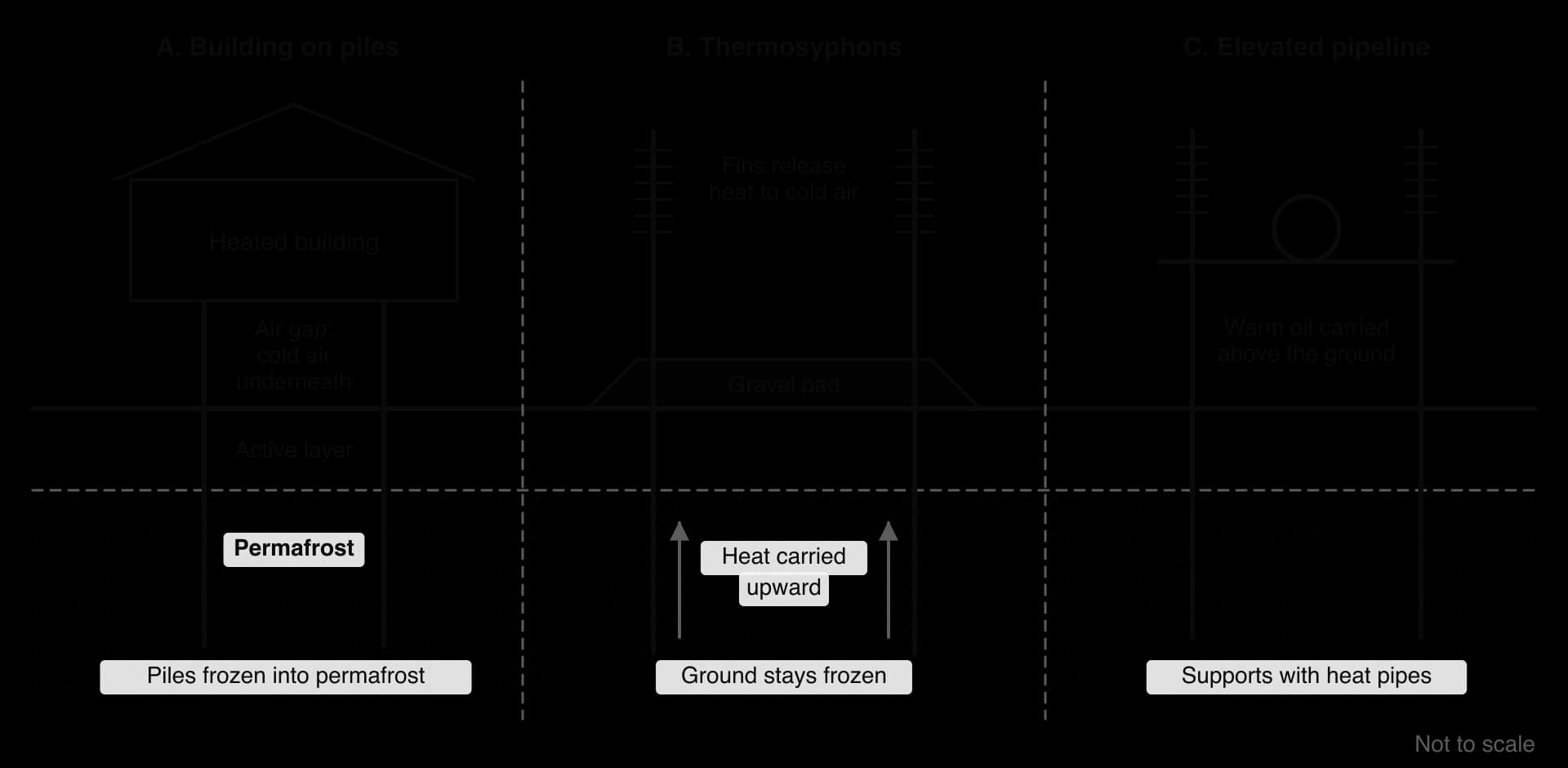
The Trans-Alaska Pipeline carries crude oil 1,288 km from the Prudhoe Bay field on Alaska’s North Slope, discovered in 1968, to the ice-free port of Valdez. Engineers warned that hot oil would thaw the permafrost and the pipe would sink and break, so where the ground is ice-rich it was built above ground on more than 78,000 vertical support members, many fitted with thermosyphons. Completed in 1977 at a cost of over US$8 billion, it carried a peak of 2.03 million barrels a day in 1988 and around 470,000 today, as the oil fields decline.
Sources: Wikipedia, “Trans-Alaska Pipeline System”, citing Alyeska Pipeline Service Company, accessed 2026.
The Tibbitt to Contwoyto Winter Road in Canada’s Northwest Territories is the world’s longest heavy-haul ice road: about 85% of its 400–600 km route runs over frozen lakes. Built each January, it is open for about 67 days on average, carrying diesel, explosives and cement to the Ekati, Diavik and Gahcho Kué diamond mines. Light vehicles need ice 70 cm thick and a loaded 42 t fuel tanker 107 cm, so warmer winters shorten the season and force the mines onto expensive air freight.
Fly-in fly-out avoids the cost of building a town, but wages are spent far from the mine, local communities gain few jobs, and workers spend long periods away from their families. Building permanent towns instead, as at Norilsk, creates communities that depend on a single industry.
Boom-and-bust cycles are common in remote mining regions because their economies depend on one or two commodities with volatile prices. Longyearbyen on Svalbard has had to turn to research and tourism since Norway closed its last coal mine there in 2025.
Much Arctic land is also the homeland of Indigenous peoples such as the Inuit, Sámi, Nenets and Iñupiat, who hunt, fish and herd on it. Mining can disturb wildlife and pollute rivers, and communities increasingly demand a say and a share of the benefits: in February 2021, Inuit hunters blockaded the Mary River iron mine for about a week in protest at a planned expansion. Environmental regulation and the risk of spills in places where clean-up is very difficult add further costs.
Resource nationalism answers the question of who should benefit from a country’s minerals. Governments argue that resources belong to the nation; companies argue that they take the risks and provide the capital, and that sudden rule changes deter investment. When commodity prices are high, governments have more bargaining power and resource nationalism tends to increase.
Form | How it works | Example in an extreme environment |
|---|---|---|
A larger state share of revenue | Higher taxes and royalties, or a set share of profit | Under the Codelco–SQM lithium agreement the Chilean state receives about 70% of the operating margin on new production |
State-owned companies and joint ventures | A state company owns or controls the resource; private firms operate it | Russia’s state-controlled Arctic oil, gas and metals |
Limits on foreign ownership | Foreign firms must sell a majority stake | Indonesia took 51% of the Grasberg copper and gold mine in the mountains of Papua (agreed 2017–18) |
Bans on extraction | Certain minerals may not be mined | Greenland banned uranium mining in 2021, blocking the Kvanefjeld rare earth project |
Nationalisation | The state takes over a company’s assets | Chile nationalised US-owned copper mines by 1971 (now Codelco); Niger nationalised the Somaïr uranium company in 2025 |
Greenland shows that resource nationalism can come from Indigenous self-government. Kvanefjeld, near Narsaq in southern Greenland, is one of the world’s largest rare earth deposits, but its ore also contains uranium. After the 2021 election, the new government banned the mining of ores with more than 100 ppm of uranium oxide; Kvanefjeld’s ore averages about 250–350 ppm, so the project was effectively stopped.
In 2022 the company, part-owned by Chinese investors, began international arbitration against Greenland and Denmark, arguing that the ban expropriated its investment. The case sets the priorities of a mostly Inuit electorate against those of a foreign investor.
In Alaska, land claims shaped the oil industry differently. The Alaska Native Claims Settlement Act (ANCSA) of December 1971 gave Alaska Natives about 44 million acres (around 180,000 km²) and US$962.5 million, managed by 12 regional and over 200 village corporations. The settlement had to come before the pipeline could be approved. Native corporations such as the Arctic Slope Regional Corporation now earn income from oil-field services and land leases, though some Alaska Natives argue that corporate ownership weakened communal ways of life.
Norilsk is an industrial city about 300 km north of the Arctic Circle in Krasnoyarsk Krai, Siberia, and the second-largest city built on permafrost, after Yakutsk. It had 176,735 residents in 2024. The mean annual temperature is −8.3 °C, snow lies for seven to nine months, and the sun does not rise from about 30 November to 13 January.
The city has no road or rail link to the rest of Russia. Ore and metal travel by a freight-only railway to Dudinka on the River Yenisei, then by river or sea; Dudinka’s port is closed each spring, when floodwater raises the Yenisei by up to 20 m.
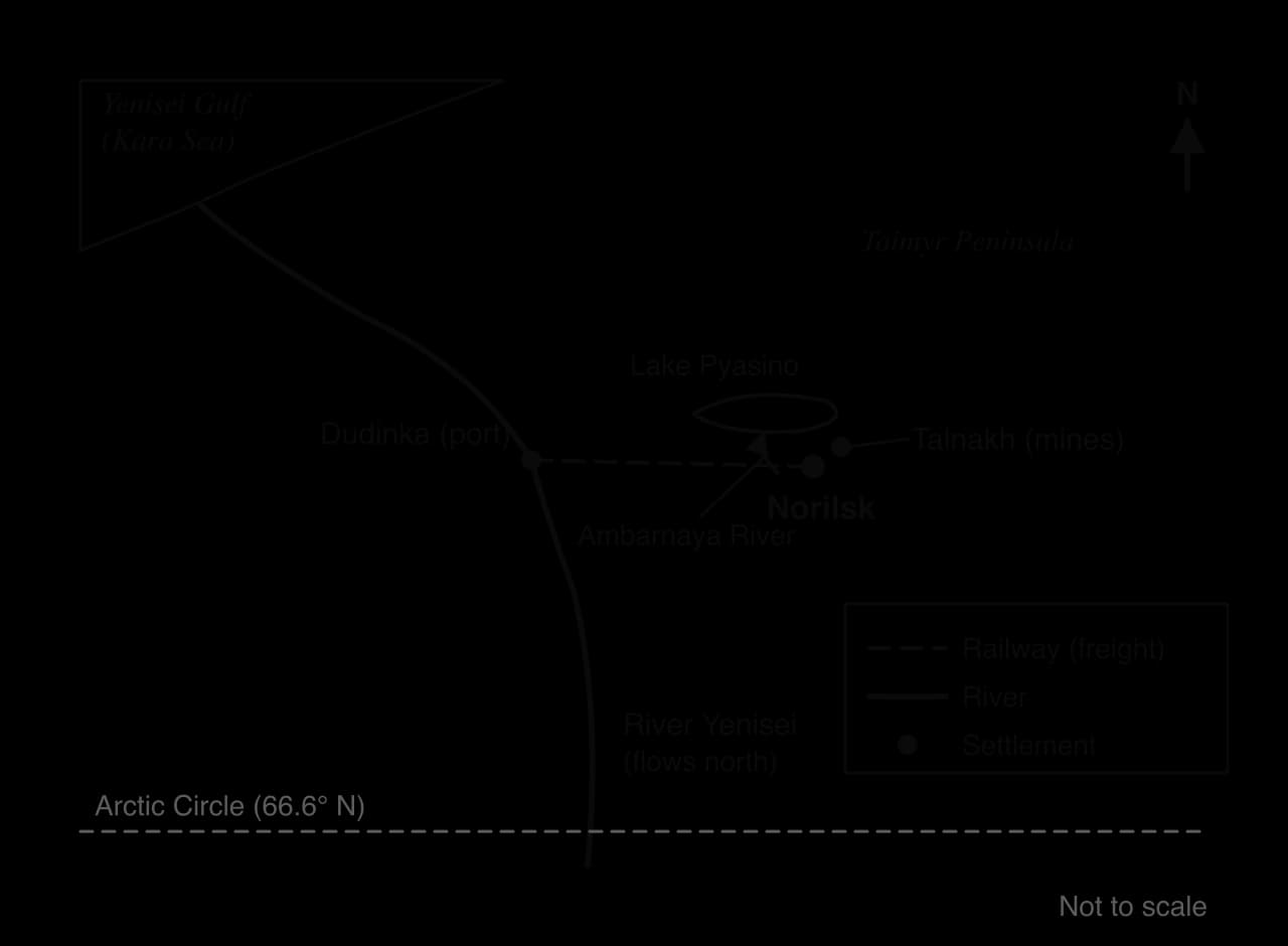
Founded in 1935 as a Gulag forced-labour camp, Norilsk is now dominated by Nornickel, the world’s largest producer of refined nickel and one of the largest producers of palladium and platinum. Heat from the city has damaged foundations as the permafrost warms, and the regional government has funded schemes to stabilise threatened apartment blocks. Pollution is severe: Russia’s statistics service listed Norilsk as the country’s most polluted city in 2017, with 1.8 million tonnes of air pollutants, mainly sulphur dioxide from the smelters.
On 29 May 2020 a diesel tank at Thermal Power Plant No. 3 failed and up to 21,000 m³ (17,500 tonnes) of fuel spilled into the Daldykan and Ambarnaya rivers and reached Lake Pyasino. The causes given were subsidence of the tank’s foundations as permafrost thawed, and corrosion. President Putin declared a state of emergency, and in February 2021 a court ordered Nornickel to pay about US$2 billion (146 billion roubles) in damages.
Power over the region is held overwhelmingly by the state and a state-aligned company. Norilsk is a closed city that foreigners may visit only with permission, the metals are treated as strategic, and after Western sanctions exports have turned towards China. Indigenous Nenets, Dolgan and Nganasan reindeer herders on the Taimyr Peninsula have far less influence.
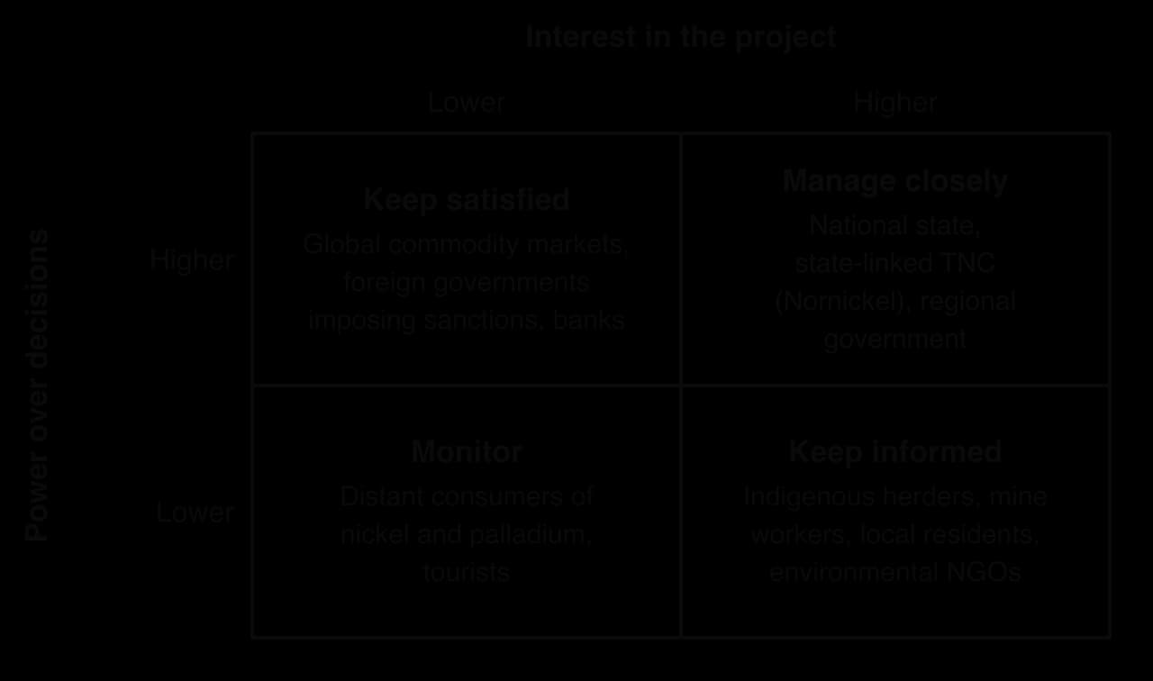
Sources: Wikipedia, “Norilsk” and “Norilsk oil spill”, citing Rosstat and court reports, accessed 2026.
Hot deserts hold some of the world’s most valuable mineral deposits. Chile’s Atacama Desert is the world’s leading source of copper and a major source of lithium; Western Australia’s Pilbara is a major iron ore region; Niger and Namibia mine uranium; and the Arabian Peninsula, Algeria and Libya hold large oil and gas reserves.
Rich and exposed deposits. With little vegetation or soil, rocks are easier to survey from the air, and the dry climate preserves nitrate deposits and lithium-rich brines that rain would dissolve or dilute elsewhere.
Low population density and open land, so there is little competition for space and few people to resettle, and open pits and waste dumps are easy to site.
Sunshine and evaporation, which can power mines with solar energy and concentrate minerals cheaply in open ponds.
Open-pit mining suits large, low-grade ore bodies near the surface, such as the copper deposits of the Andes. Escondida, in the Atacama at 3,100 m above sea level, is the world’s largest copper mine and produced about 1.28 million tonnes of copper in the year to mid-2024. Chile as a whole produced an estimated 5.3 million tonnes in 2025, about 23% of world copper mine output.
Water is the defining challenge of desert mining. Concentrators separate copper minerals from crushed ore by flotation in water, and more is used to suppress dust and lost by evaporation from tailings dams. In the Atacama, mines compete for scarce groundwater with Indigenous communities, oasis farmers and wetland ecosystems.

From 1998 to 2019 Escondida pumped up to 1,400 litres per second from wells 78 km east of the mine, upstream of the Tilopozo wetlands used by Atacameño communities. In 2022 Escondida, the lithium producer Albemarle and the neighbouring Zaldívar mine were sued over excessive groundwater extraction, and in 2024 an environmental court ordered Escondida to pay more than US$8 million in compensation. By 2024 the mine took all its fresh water from a desalination plant on the coast, pumped up to 3,100 m: this protects aquifers but uses large amounts of energy.
Climate and distance add further costs. Lowland desert temperatures can exceed 45 °C, causing heat stress; Andean mines above 3,000 m face low oxygen and altitude sickness; rare but intense storms send flash floods down dry valleys, damaging roads and tailings dams; and ore and supplies must travel hundreds of kilometres to ports.
Inaccessibility is overcome by building dedicated transport, which only very large deposits can pay for. In Western Australia’s Pilbara, iron ore companies run their own heavy-haul railways from inland mines to the ports of Port Hedland and Dampier, and Rio Tinto has operated driverless trains there since 2019.
At Bou Craa in Western Sahara, phosphate rock travels to the coast near Laayoune on a conveyor belt about 100 km long, one of the longest in the world. Western Sahara also shows how politics and distance combine: its status is disputed between Morocco, which controls most of the territory, and the Sahrawi independence movement, the Polisario Front, which argues that the phosphate is exported without the consent of the Sahrawi people.
State control. Bolivia has about 22% of the world’s known lithium resources, mostly beneath the Salar de Uyuni, but the government has kept lithium under state control and been reluctant to let foreign companies extract it, and production remains very small compared with Chile and Argentina.
Instability. In Niger, which supplies about 5% of the world’s uranium, a military coup in July 2023 was followed by the withdrawal of the French company Orano’s licence for the Imouraren deposit in June 2024, its loss of operational control of the Somaïr mine in December 2024, and the nationalisation of Somaïr in June 2025. Armed groups across parts of the Sahara and Sahel also raise the cost of protecting mines.
Indigenous rights. Chile ratified the International Labour Organization’s Convention 169 on Indigenous and Tribal Peoples in 2008, which requires consultation with Indigenous peoples on projects that affect them.
A royalty is the simplest way for a state to share in mineral wealth. Set too low, the country receives little from resources it can never replace; set too high, companies may invest elsewhere.
The two kinds of extreme environment pose different main physical problems. In cold environments the heat released by mines, buildings and pipelines threatens the frozen ground they stand on, while in arid environments the main limit is the water that processing needs. In both, political factors and the balance of power between states, companies and local people decide who receives the value of the minerals.
The Salar de Atacama is a salt flat of about 3,000 km² at about 2,300 m in the Antofagasta Region of northern Chile, 55 km south of the oasis town of San Pedro de Atacama. It lies in a closed basin between the Andes and the Cordillera Domeyko, in one of the driest places on Earth: under 30 mm of rain falls on the salar in an average year, while potential evaporation is about 3,500 mm.
Over thousands of years, water draining into the basin has evaporated and left salts behind, and the brine beneath the salt crust holds about 2,700 parts per million of lithium. Lithium is used mainly in rechargeable batteries, which accounted for about 88% of world lithium use in 2025, so it has become one of the most strategic minerals of the energy transition.
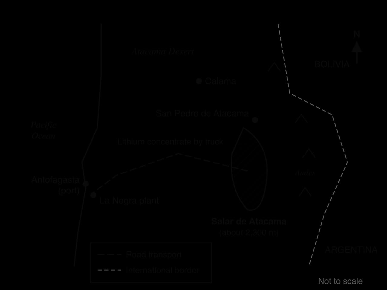
Wells pump brine from beneath the salt crust into large, shallow evaporation ponds.
Sun, wind and dry air evaporate the water over 12–18 months. Other salts crystallise first, and the brine moves from pond to pond until it holds about 6% lithium.
The concentrate is trucked to plants at Salar del Carmen and La Negra near Antofagasta and processed into lithium carbonate and hydroxide for export, mainly to battery makers in Asia.
Brine extraction uses the desert climate as part of the process, so it is cheaper and uses less energy than mining hard-rock lithium ore, as in Australia. The salar has the highest evaporation rate of any lithium brine operation, which makes it one of the world’s lowest-cost sources. Its weakness is water: the brine is groundwater, and most of it evaporates.
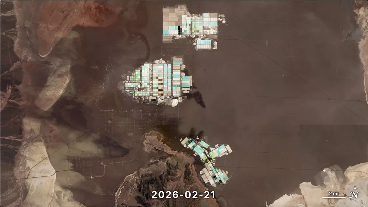
In 2017 the salar supplied about 36% of the world’s lithium carbonate. Two companies operate there, the Chilean SQM and the United States-based Albemarle; Australia, mining hard rock, overtook Chile as the largest producer in 2012.
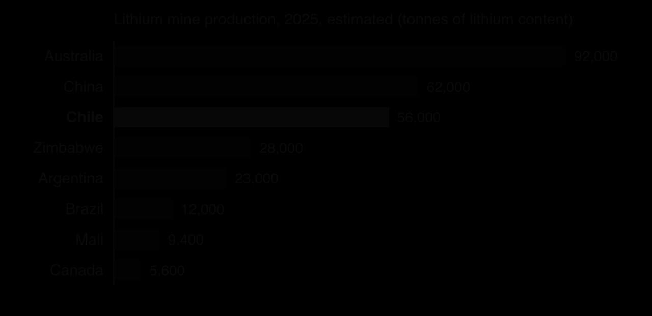
Supply is concentrated: three countries produced about 72% of the world’s estimated 290,000 tonnes in 2025. Chile holds about 9.2 million tonnes of reserves, more than any other country.
Stakeholder | Gains | Costs and concerns |
|---|---|---|
Chilean state | Royalties, taxes and a share of profits; a strategic role in the energy transition | Dependence on volatile prices; balancing growth with water and Indigenous rights |
SQM and Albemarle (TNCs) | Profits from one of the lowest-cost lithium sources | Uncertainty over contracts and state control; legal challenges over water |
Lickanantay (Atacameño) communities | Benefit-sharing payments and jobs | Loss of groundwater for farming and herding; damage to culturally important lagoons; limited control |
Water is the centre of the conflict. Pumping lowers the water table around the edges of the salar, where springs and lagoons support flamingos, grazing and small farms. The Lickanantay communities have both opposed expansion and negotiated agreements that give them a share of company revenue; critics argue that these agreements also give companies more influence over local decisions and divide communities.
Chile has long treated lithium as a strategic resource: the companies in the salar work under contracts with state agencies rather than owning the lithium outright. In April 2023 President Gabriel Boric announced a National Lithium Strategy, proposing a state lithium company, a network of protected salt flats and a public research institute, and giving the state copper company Codelco the task of negotiating with SQM.
The resulting joint venture, Nova Andino Litio, took over SQM’s operations in the salar in 2025. Codelco controls the assets and SQM runs operations, and the state should receive about 70% of the operating margin on new production, rising to 85% from 2031. This is resource nationalism by partnership rather than outright nationalisation: the state gains control and profit while keeping private expertise. Environmental groups argue that a state company will pump the same water, and Indigenous organisations want consent rather than consultation.
Economically the salar is a success, making Chile a leading lithium producer and bringing large revenues to the state. Environmentally and socially the record is mixed: the 2024 groundwater ruling, concern for the lagoons and their flamingos, and continuing disputes show that the costs fall on the people and ecosystems closest to the salar, while the benefits flow to Santiago, to shareholders and to consumers on other continents. Prices add boom-and-bust risk: battery-grade lithium carbonate averaged about US$63,700 a tonne in 2022 but only about US$9,000 in 2025, a fall of about 86%.
The case study shows all four key concepts at work: an exceptional place (a closed, high, rainless basin), physical and human processes (evaporation in the ponds, a falling water table), unequal power (the state sets the terms, TNCs bring capital, communities negotiate but cannot veto), and new possibilities such as direct lithium extraction, which returns brine to the ground.
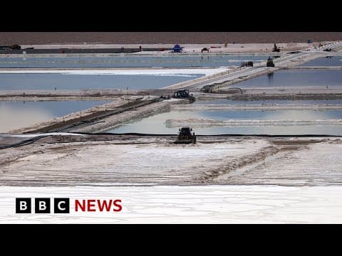 YouTube
Analysis questions
Explain why the Salar de Atacama is such a low-cost source of lithium, using both physical and human factors.
To what extent does the Codelco–SQM joint venture change who benefits from lithium extraction in the salar?
Suggest why the costs of lithium extraction are felt mainly at the local scale while the benefits are felt at the national and global scales.
Sources: USGS, Mineral Commodity Summaries 2026: Lithium and Copper (2026); Wikipedia, “Salar de Atacama”, “Lithium mining in Chile” and “Escondida”, accessed 2026; NASA Scientific Visualization Studio (2026).
Extreme environments attract tourists for the same reasons that make them difficult to live in: vast, empty landscapes, ice, deserts and high peaks, unusual wildlife, and the challenge of reaching them. Tourism is now one of the main ways in which people from elsewhere extract economic value from these places, and unlike mining it depends on the environment staying intact.
Wilderness and scenery: glaciers, ice shelves, dune seas, canyons and the polar night or midnight sun.
Wildlife: penguins and whales in Antarctica, polar bears in Svalbard and Canada, desert wildlife on safaris.
Challenge and risk: adventure tourism such as mountaineering, trekking, ice climbing, desert marathons and ski expeditions.
Seeing something before it disappears: last-chance tourism to retreating glaciers, shrinking sea ice and threatened species.
Culture: the ways of life of Bedouin, Sherpa, Inuit or Aboriginal peoples, and sacred sites; and clear skies for astronomy in the Atacama.
Types differ in impact: cruises carry large numbers but land them briefly; trekking and mountaineering bring fewer visitors who stay longer and depend on local guides; and small-scale ecotourism tries to limit impacts and fund conservation.
Income and jobs in places with few other sources of work: guiding, portering, transport, accommodation, crafts.
Infrastructure, such as airports, roads, clinics and communications, that also serves local people.
Conservation funding from park fees, permits and levies.
Economic diversification away from a single extractive industry, as in Longyearbyen after coal mining ended.
Fragile ecosystems. Cold and dry environments recover very slowly: a footpath across tundra or a tyre track across desert crust can remain visible for decades because plants grow slowly and soils form slowly.
Waste and water. At altitude and in polar regions waste does not decompose and is costly to remove; in deserts, hotels and pools compete with local people for water.
Carbon emissions. Most visitors fly long distances and then travel by ship, vehicle or aircraft, so each trip has a large carbon footprint. Last-chance tourism therefore adds to the climate change that threatens what tourists come to see.
Safety and seasonality. Rescues are expensive and dangerous, and most visits are crowded into a short season, so jobs are temporary.
Economic leakage. Much of the money spent goes to foreign tour operators, airlines and cruise companies rather than to the destination.
Leakage is especially high in extreme environments because local economies cannot supply most of what tourists use: ships, flights, equipment and much of the food are bought from outside. A cruise to Antarctica may leave almost no income in any local community at all, since there is none, while an Everest expedition led by a Nepali company keeps far more value in Nepal than one run by a foreign operator.
Antarctica has no permanent population and no government of its own. It is governed by the international Antarctic Treaty.
Tourism has grown very quickly. About 8,000 people visited a year in the mid-1990s; a 2014 study forecast 120,000 a year by 2060, a figure that was passed in the 2023–24 season. About 98% of tourist ships go to the Antarctic Peninsula, the part nearest South America, and most leave from Ushuaia in Argentina.
IAATO’s members carry most Antarctic tourists and follow rules agreed with the Treaty parties: no more than 100 people ashore at one site at a time, at least one guide for every 20 visitors, and no landings at all from ships carrying more than 500 passengers, whose visitors can only cruise and watch from the deck. In the 2025–26 season IAATO recorded 85,195 landed visitors, 27,217 cruise-only visitors and 1,106 visitors to the deep field.
Self-regulation has kept impacts low so far, but it has limits. IAATO cannot bind companies that are not members, its rules are voluntary rather than law, and the tourist season from November to March coincides with the breeding season of many species. Forecasts of up to 452,000 visitors a season by 2033–34 raise the question of whether a system designed for a few thousand visitors can cope.
 YouTube
Climbing Mount Everest (Sagarmatha in Nepali, Chomolungma in Tibetan) from the Nepal side requires a permit from the government, which cost about US$11,000 per climber in 2017. Tourism as a whole contributed 7.9% of Nepal’s GDP in 2019. Most expeditions depend on Sherpa and other Nepali guides and porters, who fix ropes, carry loads and lead clients through the dangerous Khumbu Icefall.
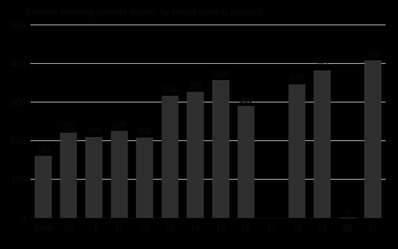
The chart shows rapid growth in demand, and with it the costs. In spring 2019 a record 891 climbers reached the summit, and 12 people died, several after long queues on the summit ridge in the thin air above 8,000 m.
The risks fall unevenly: in April 2014 an avalanche in the Khumbu Icefall killed 16 Nepali guides, after which Sherpa guides walked off the job and most expedition companies abandoned the season. Waste left at the camps and the thinning of the Khumbu Glacier, on which Base Camp stands, add environmental pressure; a plan to move Base Camp to a lower site was put on hold after resistance from Sherpa and climbing communities.
Everest shows that local stakeholders carry most of the physical risk, while national and global stakeholders hold most of the power over numbers and prices; the growth of Nepali-owned expedition companies has kept more of the income in the country.
Uluru, a sandstone monolith 348 m high in the arid centre of Australia, is sacred to the Aṉangu, its traditional owners. In 1985 the Australian government returned ownership of Uluru-Kata Tjuṯa National Park to the Aṉangu, who leased it back to the national parks agency for 99 years under joint management. Annual visitors passed 400,000 by 2000.
The Aṉangu had long asked visitors not to climb the rock, and the proportion who did fell from about a third to about a sixth by the early 2010s. In November 2017 the park’s board voted unanimously to ban climbing, and the ban took effect on 26 October 2019, the anniversary of the handback.
Uluru shows local Indigenous stakeholders gaining power over tourism through land ownership and joint management: the ban changed what tourists do rather than ending tourism.
Wadi Rum, a desert of sandstone and granite mountains in southern Jordan, has been a UNESCO World Heritage Site since 2011. The village inside it is home to several hundred Zalabieh Bedouin, many of whom earn their living from guided jeep tours, camel treks, rock climbing and overnight desert camps, so a large part of the income stays with local families rather than leaking to foreign operators.
Growth has brought its own pressures: a growing number of permanent camps stand in the protected area, jeep tracks scar the sand and fragile crusts, and water must be trucked in for showers and kitchens. The protected area authority limits where camps may be built, while the Bedouin, as the main operators, hold real influence over how tourism develops, unlike the Sherpa on Everest, who carry the risks but do not set the rules.
Svalbard, a Norwegian archipelago about 60% covered by glaciers, has received tourists since the 1890s, and tourism grew rapidly in the 1990s as coal mining declined. Most visitors arrive by cruise ship or fly to Longyearbyen for snowmobile, dog-sledding and glacier trips. Here the decisive stakeholder is the Norwegian state, which has designated national parks and nature reserves over most of the land area and has tightened the rules for ships entering them, including a ban on heavy fuel oil, which would be almost impossible to clean up after a spill in ice.
Sources: Wikipedia, “Tourism in Antarctica”, “Mount Everest”, “Uluru”, “Wadi Rum” and “Svalbard”, accessed 2026; IAATO, Data and Statistics, 2026.
Stakeholder | Scale | Main benefits | Main costs or risks | Power over tourism |
|---|---|---|---|---|
Aṉangu traditional owners (Uluru) | Local | Rent, jobs, control over sacred sites | Loss of income if visitor numbers fall | High: land ownership and joint management |
Sherpa guides and porters (Everest) | Local | Well-paid seasonal work, Nepali-owned companies | High risk of death and injury | Low to medium: can withdraw labour, as in 2014 |
Zalabieh Bedouin (Wadi Rum) | Local | Income from camps and tours stays in the village | Damage to the protected area they depend on | Medium to high: they run most businesses |
Government of Nepal | National | Permit fees, tourism revenue (7.9% of GDP in 2019) | Overcrowding, deaths and waste harm the mountain’s image | High: sets permit numbers and prices |
IAATO and cruise companies | Global | Profits from expensive voyages | Reputational risk after an accident or spill | High: rules are self-made and voluntary |
Antarctic Treaty parties | Global | Protection of a shared continent | Weak enforcement on private operators | High in principle, used slowly |
Tourists | Global | Unique experiences | Safety risks; carbon footprint of long-haul travel | Medium: choose operators and destinations |
The table shows that the stakeholders with most power over tourism are not always those who bear its costs.
Ecotourism and community-based tourism are often proposed as the answer. Ecotourism aims to keep group sizes small, educate visitors and fund conservation; community-based tourism goes further by giving local people ownership and control of the businesses, as the Bedouin largely have in Wadi Rum and the Aṉangu share at Uluru. Both reduce leakage and give local people a reason to protect the environment. Their limits are scale and transport: they cannot absorb mass demand, they are still reached by long-haul flights, and an “eco” label can be used as marketing by operators that do little to reduce their impact.
The examples suggest that tourism is most sustainable where local people hold real power over it (Uluru) and least where control is distant and numbers are allowed to grow fast (Everest, and potentially Antarctica). Even the best-managed tourism in extreme environments has a large carbon footprint, because almost every visitor travels long distances by air. Tourism in extreme environments can be sustainable at the local scale, but not fully at the global scale.
Structured questions on managing extreme environments often use a map, a table of production data or a graph of visitor numbers; extended questions usually ask you to evaluate or examine who benefits.
A second habit separates strong answers from average ones: using the key concept the question is built around.
The table shows tourism in Antarctica in the 2025–26 season.
Type of visitor | Number of visitors |
|---|---|
Landed visitors (went ashore) | 85,195 |
Cruise-only visitors (did not land) | 27,217 |
Deep-field visitors (expeditions inland) | 1,106 |
Source: IAATO, Data and Statistics, 2026.
Paper 1 extended answers are marked out of 10 with a markband. The top bands need a well-evidenced examination of the whole question and a critical conclusion grounded in geographical concepts or perspectives.
Aridity is a lack of water; infertility is poor soil. Many desert soils are fertile and become highly productive when irrigated, as in the Nile and Imperial valleys.
Modern irrigation (centre pivots, drip irrigation and fertigation) raises output but can mine fossil water, as in Saudi Arabia’s wheat programme, and cause salinisation through evaporation and rising water tables.
Land tenure decides who can farm: customary rights, pastoralists and women are often the losers in large-scale land acquisitions.
Cold-environment mining offers large reserves of oil, gas and metals, but faces extreme cold, darkness, permafrost thaw, seasonal access by ice roads, remoteness and Indigenous land claims.
Arid-environment mining is limited above all by water, as well as heat, flash floods, distance and political factors such as instability, state control and royalties.
Resource nationalism lets states take greater control and a larger share of mineral wealth, from higher royalties and joint ventures to bans and nationalisation (Chile, Russia, Greenland, Niger).
Tourism in extreme environments brings income and conservation funding but also waste, leakage and a large carbon footprint; it is managed most sustainably where local stakeholders hold real power.
I can distinguish between aridity and infertility, with an example of each.
I can describe nomadic pastoralism, oasis farming, qanats and dry farming, and explain how each manages water scarcity.
I can evaluate irrigation in arid areas, including fossil water use and the risk of salinisation, with named examples.
I can explain how land tenure and large-scale land acquisitions affect who benefits from farming in drylands.
I can explain the physical and human challenges of mining in cold environments, including permafrost, ice roads and remoteness.
I can explain the challenges of mining in arid environments, including water scarcity and political factors.
I can define resource nationalism and give examples of its different forms.
I can use the Salar de Atacama and Norilsk to examine who gains and who loses from mineral extraction.
I can evaluate tourism in extreme environments using detailed examples of local and global stakeholders.
Positive feedback: thaw releases carbon dioxide and methane from permafrost organic matter, adding to warming and further thaw.
Good answers may be well structured (AO4) and may additionally offer a critical evaluation (AO3) which distinguishes scale: local human disturbance creates intense but localized thermokarst (around settlements, roads, mines), while climate change affects whole regions. Another approach might be to consider time: thermokarst is a natural, long-standing process, but the rate and extent have increased in recent decades. Answers may note that the distinction between natural and human causes is blurred, since anthropogenic warming works through natural processes (fire frequency, active-layer deepening). Perspectives may differ between scientists, governments and indigenous communities on causes and responsibility (power).
For 5–6 marks, expect some weakly-evidenced outlining of how thermokarst forms and/or one or more causes.
For 7–8 marks, expect a structured account which includes:
either well-evidenced explanation of both natural and human causes of thermokarst development
or a discursive conclusion (or ongoing evaluation) of their relative importance, grounded in geographical concepts and/or perspectives.
For 9–10 marks, expect both of these traits.
NB. Do not credit material on limestone (karst) landscapes. Maximum [5] if only human or only natural causes are considered.
Marks | Level descriptor |
|---|---|
0 | The response does not reach a standard described by the descriptors below. |
1–2 | Too brief, lists unconnected information, not focused on the question and lacks structure. Knowledge is very general, with large gaps or errors; examples or case studies are missing or only listed. No analysis; terminology is missing or used incorrectly. |
3–4 | Too general, lacks detail, not focused on the question and largely unstructured. Outlines examples, statistics and facts, both relevant and irrelevant, with links to the question only listed. Basic terminology is used, with errors or inconsistently. No critical evaluation of evidence; any conclusion is irrelevant. |
5–6 | Partially addresses the question, with a narrow argument, an unsubstantiated conclusion and limited evaluation. Describes relevant supporting evidence (examples, case studies) and outlines links to the question. The argument repeats one point or covers only part of the question. Other perspectives, or strengths and weaknesses of evidence, are listed. |
7–8 | Addresses the whole question; the analysis is evaluated and the conclusion is relevant but lacks balance. Relevant evidence is described correctly and covers all the main points. The argument is clear but one-sided or unbalanced. Complex terminology is used correctly but not consistently. Other perspectives, or strengths and weaknesses of evidence, are described. |
9–10 | In-depth and specific to the question (topic and command term). Correct, relevant examples, statistics and detail are integrated and their link to the question explained. The argument is balanced, explaining complexity, exceptions and comparisons. Evaluation of evidence and perspectives is well developed, and the conclusion is balanced and aligned with the evidence. Logically structured and easy to follow. |
Examine the view that the unreliability of rainfall presents greater challenges for people than its low total in semi-arid environments.
10 marks
Evaluate the extent to which remoteness, rather than climate, limits human habitation in one or more named cold environments.
10 marks