C Extreme environments
See how the four parts of Extreme environments fit together, from what makes cold and arid places extreme to their landscapes, the power to extract their value, and their futures under climate change.
- IB Geography
- SL and HL
What C covers
From the subject guide: what you need to know and be able to do.
Option: cold, high-altitude and arid places, the processes that shape them and how people use them.
4 subtopics in Extreme environments
Each one has its own page once something is published for it.
- C.1The characteristics of extreme environments76 questions · notes
- C.2Physical processes and landscapes64 questions · notes
- C.3Managing extreme environments71 questions · notes
- C.4Extreme environments futures73 questions · notes
An overview of C Extreme environments
Extreme environments studies two kinds of place where climate and relief set severe limits on plants, people and economic activity: cold and high-altitude environments (polar regions, glacial and periglacial areas and high mountains) and hot arid environments (hot deserts and semi-arid areas). Drylands alone cover about 41% of the Earth’s land and are home to more than 2 billion people, while the Arctic is warming nearly four times as fast as the global average, so these places matter far beyond their small populations.
Questions that frame the option
The option follows four lines of geographical inquiry. The first asks why some places are considered extreme, and by whom. The second asks how physical processes create the distinctive landscapes of ice, frozen ground, sand and dry valleys. The third asks why states, companies, Indigenous peoples and tourists have such different power to extract economic value from these places. The fourth asks what futures are possible for extreme environments and their communities as land degrades, competition grows and the climate changes.
These inquiries lead to real questions that geographers try to answer with evidence:
Why has Svalbard warmed by about 4 °C since 1971, about five times the global rate, and what does that mean for a town built on permafrost?
Why does the Great Aletsch Glacier keep moving forward at about 180 m a year while its snout retreats up the valley?
Who benefits from the lithium pumped from beneath the Salar de Atacama, and who bears the cost of the water it uses?
Why did farmers in southern Niger restore trees on more than 5 million hectares while the Great Green Wall fell far behind its targets?
Why did Norway’s Supreme Court rule in 2021 that two wind farms at Fosen violated Sámi herders’ rights, yet the turbines kept turning?
What the option covers
The option has four subtopics, and each one deals with both kinds of extreme environment, cold and arid. The first two explain the places and their landscapes; the last two deal with how they are used and what their future holds.
Subtopic | Main question | Case study and detailed examples |
|---|---|---|
C.1 The characteristics of extreme environments | Where are cold, high-altitude and hot arid environments, why are they extreme, and what challenges do they pose for people? | Case study: Longyearbyen, Svalbard, with the Atacama Desert as a contrast. Examples: La Rinconada, Yakutsk, McMurdo Station, Siwa Oasis, Alice Springs; flash floods in Jeddah (2009) and Derna (2023) |
C.2 Physical processes and landscapes | How do glacial, periglacial, wind and water processes create the landforms of extreme environments? | Case study: the Great Aletsch Glacier, Switzerland. Examples: Red Tarn and Striding Edge, the Matterhorn, Yosemite Valley, Ibyuk Pingo, the Batagaika crater, Monument Valley, the dunes of Sossusvlei |
C.3 Managing extreme environments | Who has the power to extract value from farming, mining and tourism, and at what cost? | Case study: lithium in the Salar de Atacama, Chile. Detailed example of a cold environment: Norilsk, Russia. Tourism examples: Antarctica, Mount Everest, Uluru. Examples: Saudi Arabia’s wheat, the Trans-Alaska Pipeline, Kvanefjeld in Greenland |
C.4 Extreme environments futures | What futures are possible as desertification, competition for resources, new technology and climate change reshape these places? | Case study: desertification and re-greening in the Sahel, Niger. Detailed example: the Fosen wind farms and Sámi reindeer herders, Norway. Examples: the Great Green Wall, Benban and Noor Ouarzazate, Newtok, Imja Tsho, ice stupas in Ladakh |
How the subtopics connect
The concept map shows the main links. Climate determines which processes dominate a place, so the characteristics of the first subtopic explain the glacial, periglacial and desert landscapes of the second. The same climate, with relief, remoteness and inaccessibility, raises the cost of farming, mining and tourism, which is why the challenges of the first subtopic run straight into the management questions of the third. The physical systems of the second subtopic change under warming, through permafrost thaw, glacier retreat and glacial lake outburst floods, and the way land and resources are used today shapes what is possible in the fourth.
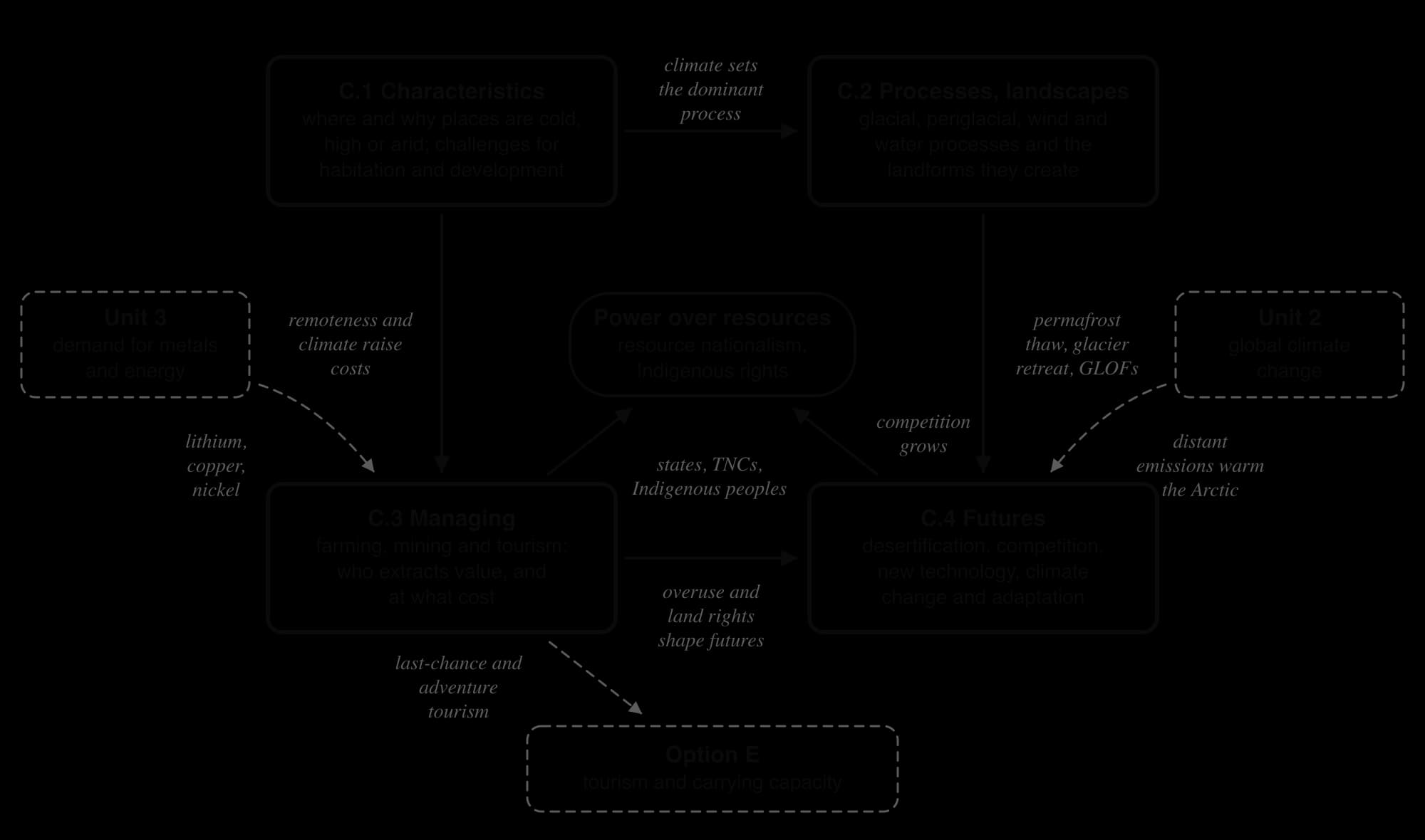
At the centre of the map is power over land and resources. Who owns the subsoil, who holds land under custom rather than title, and whose consent a project needs determine whether a mine, a wind farm or a tourist route goes ahead. People and places in extreme environments are also tied to distant places: battery makers in Asia buy Chilean lithium, tourists fly to Antarctica from every continent, and the emissions that thaw Arctic permafrost come mostly from far away.
Key concepts in Extreme environments
The four key concepts run through the option, together with three concepts that belong to it in particular: glacial systems, risk and adaptation, and resource nationalism.
Concept | How it appears in the option |
|---|---|
Place | Calling a place an extreme environment is a human-centred judgment: Indigenous peoples such as the Inuit, Sámi, Tuareg and Aṉangu have lived in these places for thousands of years. |
Process | Sinking air in the Hadley cells, freeze-thaw and frost heave, wind abrasion and flash floods, and the positive feedbacks that accelerate desertification. |
Power | States, transnational corporations, Indigenous groups and militias compete for the same land, minerals and water; local people often bear the costs while benefits flow elsewhere. |
Possibility | Farmer-managed natural regeneration against large tree belts; solar power and desalination in deserts; adaptation and its limits as the climate warms. |
Glacial systems | A glacier as an open glacial system of inputs, stores and outputs, whose glacier mass balance determines whether its snout advances or retreats. |
Risk and adaptation | Permafrost thaw, glacial lake outburst floods and extreme heat create new risks; ice stupas, relocation and changes to herding are ways of adapting. |
Resource nationalism | Resource nationalism lets states take more control of minerals: Chile’s National Lithium Strategy, Greenland’s uranium ban, the nationalisation of Niger’s Somaïr mine. |
Extreme environments are at the front line of global climate change, the core unit on climate. Arctic amplification and the thaw of permafrost are both effects of warming and feedbacks that add to it, and the lawsuit brought by Saúl Luciano Lliuya against the German company RWE over a glacial lake above Huaraz shows how people in extreme environments try to make distant emitters pay for loss and damage.
The unit on resource consumption explains the demand that drives mining: lithium, copper and nickel for batteries and the energy transition, and fossil water pumped to grow wheat in Saudi Arabia. Tourism in extreme environments, including last-chance tourism to retreating glaciers and shrinking sea ice, links the option to Leisure, tourism and sport, and irrigation and salinisation link it to Freshwater.
How SL and HL differ
Extreme environments is one of seven options. SL students choose two options and HL students choose three. The content of the option is identical at both levels: every subtopic, case study and skill is studied in the same depth, and nothing on the option’s pages is HL only.
Both levels answer the same Paper 1 question on the option, marked with the same markbands. SL and HL differ only in the number of options studied and in the HL extension units, which HL students take in addition.
Assessment
Extreme environments is examined in Paper 1. For each option studied there is a structured question built on a stimulus, worth 10 marks, followed by one extended answer worth 10 marks, chosen from two. The structured question typically has four parts: (a)(i) and (a)(ii), one mark each, read a value or fact from the stimulus; (b), two marks, asks for an outline of one cause or effect; and (c), three marks plus three, asks for two developed explanations.
Stimuli for this option are often climate graphs, maps of aridity or permafrost, a glacier mass balance graph, photographs or topographic maps of glacial and desert landforms, or data on mining and tourism. Typical short questions ask candidates to read a temperature range or a rainfall total, outline one challenge of building on permafrost or explain how a pingo or a barchan forms. Extended questions usually offer one physical theme, such as the formation of glacial landforms, and one human theme, such as the management of desertification or the power of different stakeholders to extract resources.
Carry on with C in Augment
With a free account, Augment remembers where you stopped and what you have practiced.