Model soil as a system, read soil profiles and texture, explain how soils store carbon and support ecosystems, and evaluate the causes of soil degradation, from the Loess Plateau to permafrost.
Each is in the ESS glossary, with every other term in the subject.
The movement of air into and out of soil pore spaces, which supplies oxygen to roots and soil organisms and removes carbon dioxide.
A soil formed on volcanic ash, with a low bulk density, that is often very fertile and supports intensive farming, as in Java and Japan.
A fertile, well-drained soil of temperate deciduous forest, with a deep, dark humus-rich A horizon mixed by earthworms over a brown, weakly leached B horizon.
The dry mass of soil per unit volume, including its pore spaces, usually in g cm⁻³; high values show compacted soil with little pore space.
A soil rich in calcium carbonate, usually formed on limestone or chalk parent material, with a neutral to alkaline pH.
A measure of how many positively charged ions, such as calcium, magnesium and potassium, a soil can hold on the negatively charged surfaces of its clay and humus.
The finest mineral fraction of soil, with particles smaller than 0.002 mm, made of complex silicate minerals that hold water and positively charged nutrient ions.
The squeezing together of soil particles, for example by heavy machinery or trampling, which reduces pore space, aeration, infiltration and root growth.
Describe the inorganic and organic components of soil and where each comes from.
Outline the inputs, outputs, storages, transfers and transformations of the soil system.
Construct a systems flow diagram of a soil, labelling each flow as a transfer or a transformation.
Describe how a layered soil profile develops and calculate organic matter and water content from soil samples.
Explain how soils support plant growth, biodiversity and the recycling of elements.
Explain how soil texture and humus affect nutrient retention, drainage, aeration and primary productivity.
Explain why soils can be carbon sinks, stores or sources, and why storage differs between biomes.
Evaluate the causes and consequences of soil degradation, using the Loess Plateau as a case study.
Classify soils from profile diagrams, explain the importance of the A horizon and the factors of soil formation. (HL)
Explain differences in cation-exchange capacity and interpret soil data using the soil texture triangle. (HL)
Discuss how carbon release from soils could push the climate system towards a tipping point. (HL)
Soil is the loose layer of weathered rock, organic matter, water, air and living organisms that covers most of the land surface. Almost all the food eaten on land depends on it, and it stores water, recycles nutrients, supports a huge variety of life and holds more carbon than the atmosphere and all living vegetation combined.
Soil is best studied as a system with inputs, outputs, storages and flows, connected to the water, carbon and nitrogen cycles. Because it forms over centuries but can be lost in a few years, the way people farm, graze, build on and drain land is a central question of
The official deck for this part of the syllabus.
What is soil?
What is a soil system?
With a free account, Augment remembers where you stopped and what you have practiced.
The remains of dead plants, animals and microorganisms, together with their wastes such as faeces and manure, before they are fully decomposed.
Land degradation in arid, semi-arid and dry sub-humid areas, caused by climatic variation and human activities such as overgrazing and deforestation, leading to desert-like conditions.
A field method of estimating soil texture by moistening and rubbing a small sample between the fingers to judge grittiness, smoothness and stickiness.
The accumulated droppings of seabirds or bats, rich in nitrogen and phosphate, which add nutrients to soils and have been mined as fertiliser.
Dark brown or black, partly decomposed organic matter in soil with a loose, crumbly texture, which holds water and nutrients and binds particles together.
The removal of dissolved minerals and nutrients from soil as water percolates downwards through it, carrying them to lower horizons or groundwater.
The layer of fallen leaves, twigs, bark and other dead plant parts lying on the soil surface, the main input of dead organic matter to most soils.
A deposit of wind-blown silt, often many metres thick, that forms fertile but easily eroded soils, as on the Loess Plateau of China.
A method of estimating the organic matter content of a dry soil sample by burning off the organic matter at high temperature and measuring the loss in mass.
A solid, ice-like substance in which methane is trapped within a lattice of frozen water, found in permafrost and seabed sediments and stable only when cold and under pressure.
Nitrogen, phosphorus and potassium, the three mineral nutrients that plants need in the largest amounts and that are most often measured in soil tests and added in fertilisers.
The organic layer at the top of a soil profile, made of leaf litter and humus at different stages of decomposition, above the mineral soil.
The carbon-based material in soil that comes from living things, including fresh litter, partly decomposed remains, humus and living soil organisms.
A deep, highly weathered and leached soil of humid tropical regions such as rainforests, red or yellow from iron and aluminium oxides and low in nutrients.
The underlying rock, or deposited material such as river sediment, wind-blown silt or volcanic ash, whose weathering supplies most of a soil's mineral matter.
A shallow, dark, humus-rich soil formed directly on limestone or chalk, with its topsoil lying on the shattered parent rock.
The build-up of soluble salts in soil, usually when irrigation water or a high water table evaporates near the surface and leaves its salts behind.
The coarsest mineral fraction of soil, with particles from 0.05 mm to 2 mm across, mostly quartz; it feels gritty and drains quickly.
The medium mineral fraction of soil, with particles from 0.002 mm to 0.05 mm across; it feels smooth and floury and is easily carried by wind and water.
A mixture of weathered mineral particles, organic matter, water, air and living organisms that forms the loose upper layer of the land surface and supports plant growth.
The decline in a soil's quality and its capacity to support plant growth and ecosystem services, through erosion, salinization, compaction, nutrient loss, acidification or pollution.
The removal of soil particles from one place by wind or water, faster than new soil forms, usually starting with the most fertile topsoil.
The five factors that control how a soil develops: climate, organisms, geomorphology (relief), geology (parent material) and time.
A layer of soil, roughly parallel to the surface, that differs from the layers above and below in colour, texture, organic matter or other properties.
A vertical section through a soil from the surface down to the parent material, showing its sequence of horizons.
An open system in which soil components are stored, gain inputs such as litter and weathered minerals, lose outputs such as eroded and leached material, and undergo transfers and transformations.
The physical make-up of the mineral part of a soil, given by the relative proportions of sand, silt and clay particles.
A triangular diagram that assigns a soil to a texture class, such as loam or silty clay, from its percentages of sand, silt and clay.
The mostly mineral layer (B horizon) beneath the topsoil, with less organic matter, into which clay, iron compounds and nutrients may be washed from above.
The upper mineral layer of soil (A horizon), rich in humus, roots and organisms, where most nutrient recycling and biological activity take place.
The amount of water a soil can retain in its pores against gravity after free drainage, which depends mainly on its clay and humus content.
The condition in which all the pore spaces in a soil are filled with water, so that oxygen is excluded and anaerobic conditions develop.
The breakdown of rock in place into smaller particles and dissolved ions by physical, chemical and biological processes, without the material being moved away.
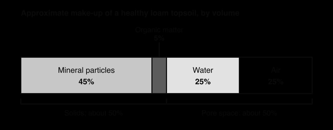
A handful of soil looks simple, but it is a mixture of four very different materials: mineral particles, organic matter, water and air. In a typical healthy topsoil, solid particles take up about half of the volume and the spaces between them (the pore space) take up the other half. The pores are usually shared between water and air, and the balance shifts after every rainfall and dry spell.
The proportions change from place to place and with depth. A waterlogged soil has almost no air, a desert soil very little water and organic matter, and a peat soil may be mostly organic. The figure therefore shows a typical loam topsoil, not a fixed recipe.
The inorganic part of soil is made of rock fragments and mineral particles of different sizes: gravel, sand, silt and clay. They come from the weathering of rock, either the solid rock beneath the soil or material carried in and dropped by rivers, glaciers or the wind. The rock or deposit from which a soil forms is called its parent material.
Weathering happens in three main ways. Physical weathering breaks rock into smaller pieces without changing it chemically, for example when water freezes and expands in cracks. Chemical weathering changes the minerals themselves, for example when slightly acidic rainwater dissolves calcium carbonate or turns feldspar into clay. Biological weathering is caused by living things, such as roots that widen cracks and lichens that release acids.
Weathering also releases dissolved mineral ions, such as calcium, magnesium and potassium, into the soil water. These are the source of most of the nutrients that plants take up, so the chemistry of the parent rock strongly affects how fertile a soil can become.
The organic part of soil has two parts. The first is living organisms: plant roots, fungi, bacteria, earthworms, insects, mites, nematodes and many others. The second is dead organic matter, which includes fallen leaves, dead roots, dead animals, faeces and manure at every stage of decay.
As dead material is broken down, most of it is respired away as carbon dioxide, but part of it is turned into humus, a dark, stable substance that can remain in soil for decades or centuries. Humus coats mineral particles, binds them into crumbs and holds water and nutrients, so even a few per cent of humus changes how a soil behaves.
Because it contains its own producers (roots), consumers and decomposers, interacting with one another and with the mineral, water and air components, a soil is an ecosystem in its own right as well as a part of the larger terrestrial ecosystem above it. Soil scientists group soils into types using published classification keys, many of them online, which ask a series of questions about colour, layers, texture and chemistry, in the same way that a dichotomous key identifies an organism.
A soil can be modelled as an open system: matter and energy cross its boundary in both directions. Its storages are the organic matter, the mineral particles, the soil water with its dissolved nutrients, and the soil air. Inputs add to these storages, outputs remove material from them, and flows move material between them or change it into something else. Viewing soil this way shows that it is never static. A soil that looks unchanged from year to year is in a steady-state equilibrium, with inputs balancing outputs.
Inputs fall into two groups. Dead organic matter enters as leaf litter, dead roots, dead animals and animal waste. Inorganic inputs include minerals released by weathering, material deposited by wind or water, water from precipitation (which carries dissolved minerals), gases such as oxygen and nitrogen from the air, and solar energy, which warms the soil and speeds up chemical and biological processes.
Some natural inputs come from inside the ecosystem, such as litter from the vegetation above and weathering of the rock beneath. Others are carried in from different ecosystems. Wind-blown dust, river floodwater that leaves a layer of silt, and guano from seabirds that feed at sea all add material produced somewhere else.
The seabird islands off the coast of Peru are an example of an input from another ecosystem. Cormorants, pelicans and boobies feed on fish in the nutrient-rich coastal ocean and nest on dry offshore islands, where their droppings built up as thick deposits of guano, rich in nitrogen and phosphate. In the nineteenth century this guano was mined and shipped to Europe as fertiliser, with Peru’s exports peaking at more than 700,000 tonnes in 1870, so a nutrient transfer from sea to land became a global trade.
Sources: Wikipedia, “Guano” (2026).
In managed soils, many inputs are anthropogenic: fertiliser, compost and manure, pesticides and other agrochemicals, and irrigation water. These raise productivity but can also change the soil in unwanted ways, for example by adding salts or by making the soil more acidic.
Outputs remove material from the soil storages. Decomposers break down dead organic matter, and the carbon leaves as carbon dioxide (or methane in waterlogged soil). Plant roots absorb water and mineral nutrients. Water evaporates from the surface, gases diffuse out into the atmosphere, and heat is lost by radiation and conduction. Water draining through the soil carries dissolved nutrients down and out of reach of roots, a process called leaching.
The most damaging output is soil erosion: the removal of soil particles by wind or water. Most outputs change the make-up of the soil, for example by removing nitrate or organic matter, while leaving the soil itself in place. Erosion removes the soil as a whole, starting with the fertile surface layers, and can strip a field down to infertile subsoil or bare rock.
Flows within and through the soil are of two kinds. A transfer moves material or energy from one place to another without changing it. A transformation changes material into a new form, a new chemical or a new state. Labelling each flow on a soil diagram as one or the other is a useful check on how well the processes are understood.
Flow | Type | What happens |
|---|---|---|
Infiltration | Transfer | Water soaks from the surface into the soil. |
Percolation | Transfer | Water moves down through the soil pores towards the bedrock and the water table. |
Groundwater flow | Transfer | Water moves sideways through saturated soil and rock, towards rivers and the sea. |
Biological mixing | Transfer | Earthworms, ants, termites and burrowing mammals carry organic matter down and mineral soil up. |
Aeration | Transfer | Oxygen diffuses into the pores; carbon dioxide diffuses out. |
Leaching | Transfer | Dissolved nutrients are carried down in percolating water. |
Erosion | Transfer | Soil particles are carried away by wind or water. |
Decomposition | Transformation | Dead organic matter is broken down into humus, carbon dioxide, water and mineral ions. |
Weathering | Transformation | Rock is broken down into particles and its minerals are changed and dissolved. |
Nutrient cycling | Transformation | Nutrients are converted between organic and inorganic forms, for example organic nitrogen to ammonium and nitrate. |
Salinisation | Transformation | Salts build up and crystallise as water evaporates, changing the chemistry of the whole soil. |
Some processes contain both kinds of flow. During leaching, the movement of dissolved nitrate downward is a transfer, but the earlier conversion of organic nitrogen into nitrate by bacteria is a transformation. When a process is complex, labelling its separate steps avoids confusion.
Salinisation is the build-up of soluble salts, such as sodium chloride and sodium sulfate, in the soil. All irrigation water and groundwater contain small amounts of dissolved salt. In hot, dry climates, water evaporates from the surface and is taken up by plants, but the salts stay behind. Over years, they accumulate in the root zone and can form a white crust on the surface.
Poor drainage makes the problem worse. If irrigation raises the water table to near the surface, salty groundwater is drawn up by evaporation and deposits its salts as it dries. After the Aswan High Dam was completed in Egypt in 1970, year-round irrigation kept the water table high across parts of the Nile Delta, and salinisation of farmland followed. High salt concentrations make it hard for plants to take up water, so yields fall and, in severe cases, the land is abandoned.
A global assessment published in 2024 estimated that about 1,381 million hectares, around 10.7% of the world’s land area, is affected by salt, including about 10% of irrigated cropland.
Sources: FAO, Global status of salt-affected soils (2024); Wikipedia, “Soil salinity” (2026).
A soil systems diagram follows the usual conventions: storages in boxes, flows as arrows labelled with the process, and the system boundary as a dashed line. Inputs cross the boundary inwards, outputs cross it outwards, and transfers and transformations between storages stay inside it.
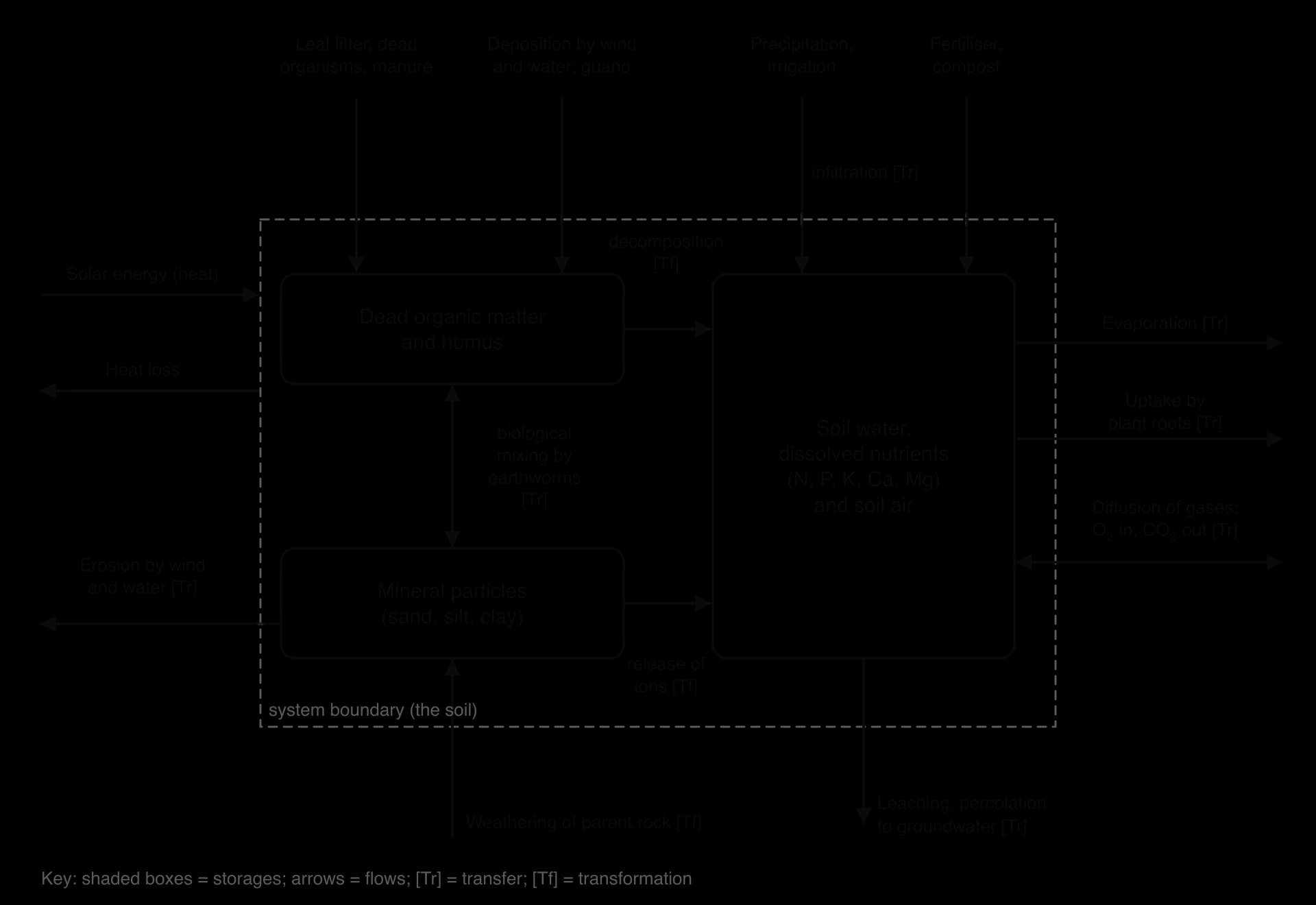
The diagram also shows why soils are essential to the major biogeochemical cycles. Infiltration, storage and percolation make soil part of the hydrological cycle. Litter inputs and decomposition outputs make soil one of the largest stores in the carbon cycle. Decomposition, nitrogen fixation by soil bacteria and uptake by roots place soil at the centre of the nitrogen cycle.
 YouTube
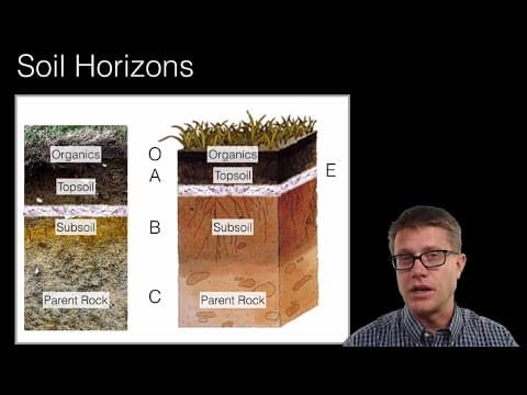
The wall of a pit dug a metre or two into the ground is rarely uniform. Most soils are arranged in roughly horizontal layers called horizons, which differ in colour, texture, structure and organic matter. The whole sequence, from the surface down to the parent material, is the soil profile.

Horizons form because the main processes work from opposite ends of the profile. Organic matter arrives at the top as litter and is mixed downwards by organisms, so the upper layers are dark and rich in humus. Weathering works on the rock at the bottom, so the lower layers are increasingly made of broken, less weathered rock. Between them, water percolating down carries dissolved ions and fine clay particles from upper layers into lower ones.
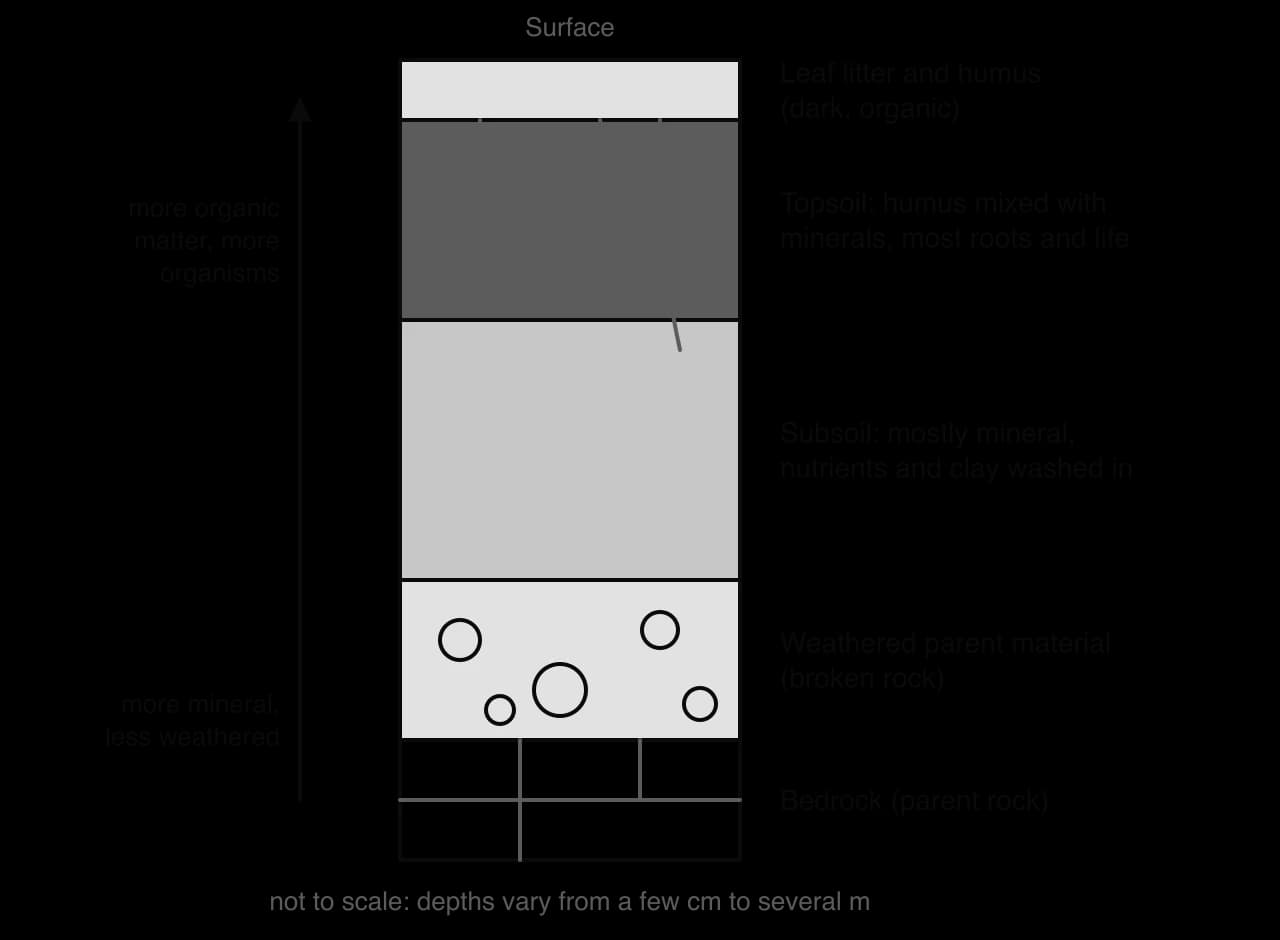
The upper mineral layer, the topsoil, is where most roots grow and most organisms live. Below it, the subsoil holds less organic matter and more clay, iron and aluminium compounds and nutrients washed in from above. A stable profile develops over hundreds to thousands of years, as the inputs, outputs and flows of the soil system act on the same material for a long time. Where the vegetation, climate or land use change, the profile changes too.
Soil colour gives quick clues about these processes. Dark brown or black colours usually show plenty of humus. Red and yellow colours come from iron oxides in well-drained, well-aerated soil. Grey or blue-grey colours, often with orange mottles, are typical of soils that are waterlogged for long periods, where iron has been chemically reduced because oxygen is absent.
A useful comparison is between two samples of subsoil taken at the same depth: one from a managed site, such as a garden or a field, and one from a nearby natural ecosystem, such as a woodland. Sampling the subsoil avoids the large differences caused by the litter on the surface, and differences in the subsoil show the longer-term effects of land use. The samples can be tested for:
Texture: by feel or by sedimentation in water.
Organic matter: by loss on ignition (burning a dried sample).
NPK: the concentrations of nitrate, phosphate and potassium, using a soil test kit with colour charts.
Aeration: estimated from the volume of air in the pores, by measuring how much water a known volume of soil can take in before it is saturated.
Drainage and infiltration: the time water takes to soak into the soil from a ring pushed into the ground.
Water retention (water-holding capacity): the mass of water a saturated sample keeps after free drainage.
Organic matter content is found by loss on ignition. A soil sample is first dried in an oven at about 105 °C until its mass stops changing, which removes the water. It is weighed, heated strongly in a crucible (usually 400–550 °C) until the organic matter has burned away, cooled and weighed again. The loss in mass is the organic matter, which contains most of the soil’s carbon.
Almost every terrestrial food chain begins with plants rooted in soil, so soil is often described as the foundation of terrestrial ecosystems. It does three jobs for the ecosystem above it: it is the medium in which plants grow, a habitat for an enormous diversity of organisms, and the place where most of the elements in dead material are recycled.
Soil anchors roots and supplies plants with water and with almost all of the mineral nutrients they need. The three needed in the largest amounts are nitrogen, phosphorus and potassium. Nitrogen is used to build proteins and chlorophyll, phosphorus to build DNA and the energy carrier ATP, and potassium to control the opening of stomata and the movement of water. Calcium, magnesium, sulfur, iron and several trace elements are also taken up from the soil water.
Soil is also a store of water between rainfall events, and it holds a natural seed store: dormant seeds of many species can survive for years in the soil and germinate after a disturbance such as a fire or a fallen tree. This buried seed store is one reason why bare ground is quickly recolonised during succession.
Soil provides a habitat and many different niches for organisms of every size: bacteria, archaea, fungi, protists, nematodes, mites, springtails, insect larvae, earthworms, ants, termites and burrowing mammals such as moles. Conditions change sharply over a few millimetres, from a wet pore to a dry one, or from oxygen-rich to oxygen-poor, so many species can live side by side.
A review of the biodiversity literature published in 2023 estimated that soil is home to about 59% of all species on Earth (with an uncertainty of about ±15%), which would make soil the single most species-rich habitat. About 90% of fungal species were estimated to live in soil. Many soil species, especially microorganisms, have never been described, because most cannot yet be grown in a laboratory.
Sources: Anthony et al., “Enumerating soil biodiversity”, PNAS (2023).
The major input to most soils is dead organic matter from plants. Without decomposition, nutrients would stay locked in dead leaves and wood, and the supply available to living plants would run out. Two groups of organisms carry out the work, one after the other.
Detritivores, such as earthworms, woodlice, millipedes and springtails, eat dead material and break it into smaller fragments. This greatly increases the surface area for microorganisms to act on.
Saprotrophs, mainly fungi and bacteria, secrete enzymes onto the dead material and absorb the products. They release carbon dioxide in respiration and convert organic nitrogen, phosphorus and sulfur into inorganic ions, such as ammonium and phosphate, that plants can take up again.
Earthworms also mix the soil as they burrow, pull leaves down from the surface and leave behind casts rich in nutrients. In 1881 Charles Darwin published a whole book on how earthworms bring soil to the surface and slowly bury objects such as fallen stones, one of the first studies of soil organisms as engineers of their own environment.
Because soil links decomposition, nutrient uptake and water storage, damage to a soil affects every part of the ecosystem above it. These benefits are among the most valuable ecosystem services that natural ecosystems provide to people, from food production to flood control.
Two soils with exactly the same minerals can behave very differently if their particles are of different sizes. Soil texture describes the physical make-up of the mineral part of a soil, given by the proportions of sand, silt and clay it contains. Humus, where it is abundant, also affects how a soil feels and behaves.
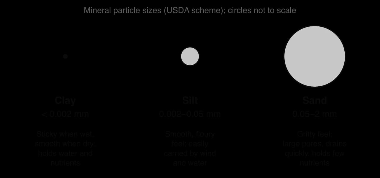
Particle size is grouped into three classes. Sand particles are 0.05–2 mm across, mostly grains of quartz, and feel gritty. Silt particles are 0.002–0.05 mm and feel smooth and floury, like talcum powder. Clay particles are smaller than 0.002 mm, made of flat, layered silicate minerals that feel sticky when wet and set hard when dry. Particles larger than 2 mm are gravel and stones, which are not counted in the texture.
A soil with roughly balanced amounts of sand, silt and clay, so that none dominates its behaviour, is called a loam. Loams are usually the most productive soils for farming, because they combine the drainage and aeration of sand with the water and nutrient retention of clay.
Texture can be found in three ways. In the field, a soil can be identified using a printed or online key, which asks a series of yes-or-no questions about how the soil feels and behaves. The most common field method is the feel test. In the laboratory, texture can be measured by sedimentation.
Feel test: a small sample is moistened and worked between the thumb and fingers. Gritty particles show sand; a smooth, silky feel shows silt; stickiness and the ability to form a long ribbon show clay. The longer the unbroken ribbon pushed out between thumb and finger, the more clay the soil contains.
Sedimentation (jar) test: soil is shaken in a jar of water, often with a little dispersing agent such as washing-up detergent or sodium hexametaphosphate to separate the particles, then left to settle. Sand sinks within about a minute, silt over the next hours, and clay can take a day or more. The thickness of each layer gives an estimate of the proportions.
Texture matters to plants because it controls the size of the pores between particles. Large pores, typical of sandy soils, let water drain quickly and air move freely, but hold little water for roots. Very small pores, typical of clay soils, hold water tightly and for a long time, but drain slowly and can fill completely with water, shutting out air. Clay and humus particles also carry negative electrical charges on their surfaces, which hold positively charged nutrient ions such as potassium and calcium and stop them being leached.
Each texture therefore involves a trade-off between three pairs of properties: nutrient retention against leaching, water retention against drainage, and aeration against compaction and waterlogging. These properties together determine how much a plant can grow, so they control the primary productivity of the soil.
Property | Sandy soil | Silty soil | Clay soil | Effect of humus |
|---|---|---|---|---|
Nutrient retention | Low: nutrients leach easily | Medium | High: ions held on clay surfaces | Raises retention; holds and slowly releases nutrients |
Water retention | Low: dries out quickly | High | High, but some water held too tightly for roots | Raises retention, like a sponge |
Drainage | Fast | Medium to slow | Slow; prone to waterlogging | Improves drainage in clay by forming crumbs |
Aeration | Good | Medium; surface can crust | Poor when wet; easily compacted | Improves aeration by opening up pore spaces |
Ease of working | Light, easy to dig | Easily eroded and compacted | Heavy, sticky when wet, hard when dry | Makes heavy soils easier to work |
Primary productivity | Low unless watered and fertilised | Often high | High if drained | Raises productivity of all textures |
Humus is especially important. It is a dark brown or black substance lying beneath the leaf litter, with a loose, crumbly texture, formed by the partial decay of dead plant material. It sticks particles together into crumbs, so it opens up dense clay soils and binds loose sandy ones. It can hold several times its own mass of water, and its many charged surfaces hold nutrients. A small increase in humus can make a poor soil much more productive.
Compaction and waterlogging both reduce productivity by cutting off oxygen from roots and soil organisms. Compaction squeezes particles together, often under heavy farm machinery or the hooves of crowded livestock, and it is worst in wet clay soils. Waterlogging fills every pore with water; roots and aerobic decomposers then cannot respire, and anaerobic bacteria produce methane and reduce iron, which gives waterlogged soils their grey colour.
Soil organic matter is about half carbon by mass, so every soil is a carbon store. Down to a depth of one metre, the world’s soils hold roughly four times as much carbon as all the living vegetation on land. Whether a particular soil is gaining or losing carbon depends on the balance between two flows: the input of dead organic matter, and the rate of decomposition, which returns carbon to the atmosphere as carbon dioxide or methane.
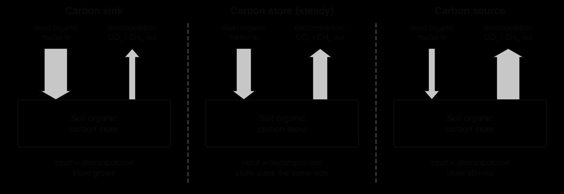
When inputs exceed decomposition, the soil is a carbon sink and its store grows. When they are equal, it is a stable store in steady state. When decomposition exceeds inputs, the soil is a carbon source. A natural soil in a mature ecosystem is usually close to a steady state, but changes in climate or land use can tip the balance either way.
Decomposition depends on temperature, moisture and oxygen. Decomposers work fastest when the soil is warm, moist and well aerated, and slowest when it is cold, very dry or waterlogged. The amount of carbon stored in a soil therefore reflects both how much litter the vegetation produces and how quickly that litter is broken down.
Tropical rainforest soils store relatively little carbon for such productive ecosystems. Litter fall is very high, but in constant warmth and moisture, leaves are decomposed within weeks and the nutrients are quickly taken back up by roots. Heavy rainfall leaches what is left. Most of the carbon and nutrients in the ecosystem is held in the living trees, not in the soil.
Tundra soils are cold for most of the year, and many lie on permafrost that keeps the deeper soil frozen. Decomposition is extremely slow, so dead plant material builds up over thousands of years, even though plant growth is low.
Wetland soils, such as peat bogs and mangroves, are waterlogged. With no oxygen, aerobic decomposers cannot work, and dead plant material accumulates as peat.
Temperate grassland soils receive a large input of organic matter from the dense, deep roots of grasses, which die and are renewed every year. Cold winters and dry summers slow decomposition. The result is deep, black, humus-rich soils such as the chernozems of the steppes of Ukraine and Russia, which contain about 4–16% humus.
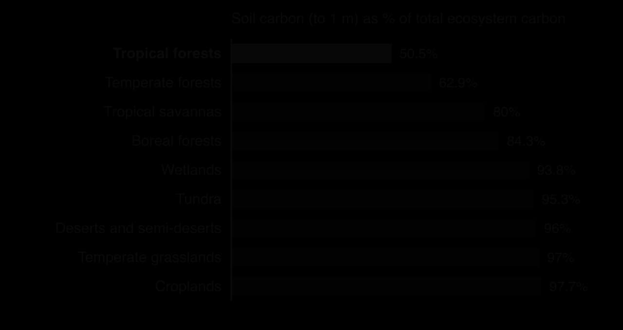
The chart shows the share of each biome’s carbon held in its soil rather than its vegetation. The tropical forest bar is the lowest because so much of its carbon is held in tree biomass. Tundra and wetlands store most of their carbon in the soil, and the estimates to one metre leave out the deeper peat and permafrost, so their real stores are larger still.
Sources: IPCC, Land Use, Land-Use Change and Forestry, Summary for Policymakers, Table 1 (2000); Wikipedia, “Chernozem” (2026).
Human activity can turn soils from stores into sources. Ploughing breaks up soil crumbs and lets oxygen in, speeding up decomposition, and leaves soil bare and open to erosion. Draining wetlands and peat bogs for farming or plantations lets air into the peat, which then decomposes or burns. On the other hand, practices that add organic matter and disturb the soil less, such as cover crops, zero tillage and agroforestry, can help soils act as sinks.
These methods belong to sustainable farming and are evaluated there; their effect on soil carbon is still debated, because gains are slow, may stop once a new steady state is reached and can be reversed if the land is ploughed again.
Soil degradation is any decline in a soil’s quality and its capacity to support plants and provide ecosystem services. It can mean the loss of soil itself by erosion, or a change in what remains: loss of nutrients and organic matter, salinisation, compaction, acidification or pollution with heavy metals and other chemicals. In 2015, about 33% of the world’s soils were estimated to be moderately to highly degraded.
Sources: FAO, “Soil is a non-renewable resource”, International Year of Soils fact sheet (2015).
Soil is classed as effectively non-renewable on a human timescale. Weathering and the build-up of organic matter create new soil very slowly, in many climates at about a tenth of a millimetre a year or less, while a single heavy storm on bare, sloping ground can remove several millimetres. Soil lost in a few decades may take centuries or millennia to replace.
Vegetation protects soil in several ways: leaves and litter absorb the energy of falling raindrops, roots bind the soil together, and plant cover slows the wind at ground level. When vegetation is removed, by deforestation, overgrazing, ploughing or construction, the soil is exposed. Raindrops dislodge particles, and water running across the surface carries them away, first as a thin sheet, then in small channels (rills) and finally in deep gullies. Wind lifts dry, loose particles, especially fine sand and silt, and can carry silt and clay hundreds or thousands of kilometres.
Erosion can become self-reinforcing. Once the topsoil has gone, the subsoil holds less water and fewer nutrients, so fewer plants can grow on it. Less plant cover leaves the ground more exposed, so even more soil is eroded. This is a positive feedback loop that can carry a slope past a tipping point into a bare, gullied state that does not recover by itself.
The Dust Bowl on the Great Plains of the United States in the 1930s is a well-known example of wind erosion. Farmers had ploughed up large areas of native prairie grassland to grow wheat, removing the deep-rooted grasses that had held the soil. When severe droughts struck in 1934, 1936 and 1939–1940, the bare, dry soil blew away in huge dust storms, such as “Black Sunday” on 14 April 1935.
About 100 million acres (400,000 km²) were affected and about 3.5 million people left the Plains states during the decade. In 1935 the US government set up the Soil Conservation Service to promote ways of farming that hold the soil in place.
Sources: Wikipedia, “Dust Bowl” (2026).
Form of degradation | Main human causes | Effect on the soil system |
|---|---|---|
Nutrient depletion | Harvesting crops year after year without returning nutrients; monoculture | Output of N, P and K in crops exceeds inputs; organic matter and fertility fall |
Salinisation | Irrigation in dry climates with poor drainage | Salts accumulate in the root zone; plants cannot take up water |
Compaction | Heavy machinery, trampling by livestock, especially on wet soil | Pore space, aeration and infiltration fall; more run-off and erosion |
Acidification | Ammonium-based fertilisers; acid deposition; some conifer plantations | Nutrients such as calcium are leached; toxic aluminium is released |
Pollution | Mining, industrial waste, sewage sludge, pesticides | Heavy metals and persistent chemicals harm organisms and enter food chains |
Loss of organic matter | Ploughing, burning crop residues, draining peat | Weaker structure, lower water retention, carbon released |
Where these processes affect drylands, the result is desertification: the degradation of land in arid, semi-arid and dry sub-humid areas until it resembles desert. It is driven by a combination of climatic variation, such as long droughts, and human activities, such as overgrazing, overcultivation and the cutting of trees and shrubs for fuel. It is not the same as the natural expansion of an existing desert.
Soil degradation affects people unequally. Farmers in low-income countries who depend on their own land for food, and who cannot afford fertiliser to replace lost nutrients, are the most exposed, which links soil loss to environmental justice. How a society responds also depends on how it values soil.
Perspective | How soil is seen | Typical response to degradation |
|---|---|---|
Technocentrism | A medium for production that technology can maintain or replace | Synthetic fertiliser, irrigation, drainage engineering, soil-less hydroponic and vertical farming |
Anthropocentrism | Natural capital that must be managed for long-term human benefit | Regulation and incentives for soil conservation, land-use planning, payments to farmers |
Ecocentrism | A living ecosystem with its own value, home to most of Earth’s species | Protecting natural vegetation, restoring soil biodiversity, farming with lower inputs and less disturbance |
Halting degradation is part of Sustainable Development Goal 15 (Life on land), whose target 15.3 aims to restore degraded land and soil and to achieve a world in which land degradation is balanced by restoration. The practical methods of conserving soil, such as terracing, contour ploughing, windbreaks, crop rotation and adding organic matter, are evaluated with farming systems in agriculture and food.
The Loess Plateau covers about 635,000 km², around 6.6% of China’s land area, in the middle reaches of the Yellow River. It is built of loess, fine silt blown from the Gobi and nearby deserts and deposited over roughly the last 2.4 million years. Near the Liupan Mountains the loess is 200–300 m thick, and near the Yellow River about 100 m.
Loess makes a soil that is fertile and easy to dig, which is why the plateau has been farmed for thousands of years and is home to about 108 million people (2010). Its texture also makes it one of the most erodible soils on Earth. Silt particles are small enough to be carried easily by water but too large and too poor in clay and humus to stick together well. The climate adds to the risk: the north of the plateau is semi-arid and the south sub-humid, and 40–60% of the year’s rain falls from June to August, often in intense storms.
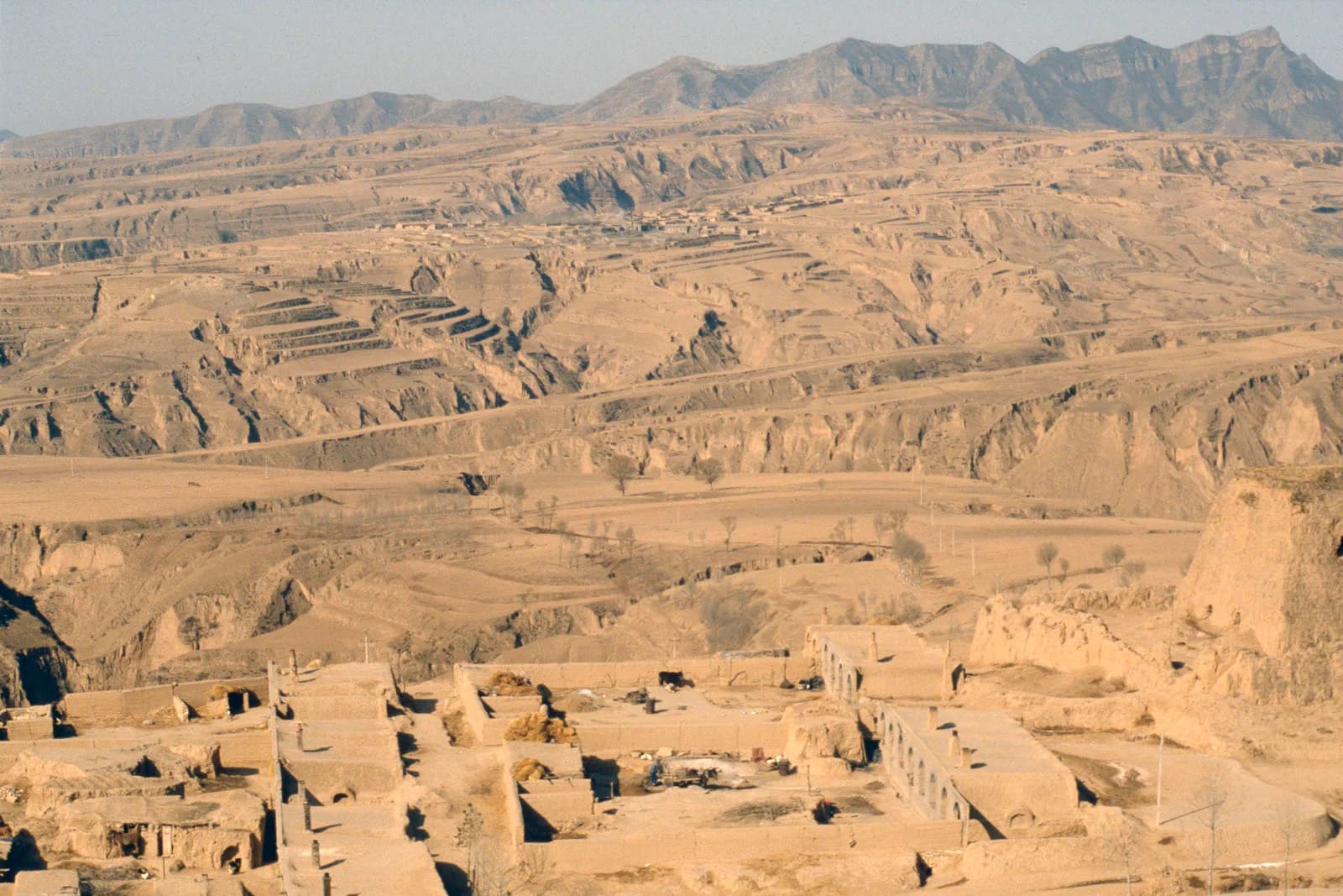
Viewed as a system, the plateau’s soil was once a large store protected by vegetation, with inputs from litter and dust roughly balancing small outputs by erosion. Over three thousand years, forest cover fell about eight-fold as land was cleared for crops, grazing and fuel, reaching its lowest point in 1949. By then, more than 70% of the sloping land was farmed, and population growth after 1949 pushed cultivation further up steep slopes.
With little vegetation to absorb raindrops and bind the silt, the summer storms turned the soil system’s largest output into erosion by water. In 1949 the plateau was losing about 3,700 tonnes of soil per km² per year. Run-off cut networks of deep gullies, which produced 60–90% of the sediment in hilly areas. The lost topsoil carried away organic matter and nutrients, so crop yields on the remaining slopes were low and many households were poor.
The eroded soil did not disappear. More than 90% of the sediment in the Yellow River comes from the Loess Plateau, which is why the river is named after its colour and has been among the most sediment-laden rivers in the world. Downstream, the sediment settled on the riverbed, raising it above the surrounding plain in places and increasing the risk of catastrophic floods, so erosion on the plateau also imposed costs on people hundreds of kilometres downstream.
From the 1970s, Chinese authorities built terraces, check dams across gullies (small dams that trap sediment and create flat land behind them) and reservoirs. In 1994 the Loess Plateau Watershed Rehabilitation Project began, supported by the World Bank, in nine tributary watersheds covering 15,600 km². Its approach combined engineering with revegetation and changes to land use.
Measure in the 1994 project | Scale | Effect on the soil system |
|---|---|---|
Terraces built on slopes | 72,346 ha | Slopes broken into flat steps: run-off slowed, infiltration raised, erosion output reduced |
Trees, shrubs and grasses planted | 270,000 ha | Vegetation cover intercepts rain, roots bind soil, litter input rebuilds organic matter |
Sediment control dams | Several thousand | Eroded silt trapped in gullies before reaching the river; new flat farmland behind the dams |
Result for farming | Average year | Grain yields on terraces about double those on sloping land |
Sources: UN DESA, Loess Plateau Watershed Rehabilitation Project success story (2000); Wikipedia, “Loess Plateau” (2026).
In 1999 the national Grain for Green programme extended the approach across the plateau and beyond. It banned cropping on steep hillsides and free grazing, and paid farmers in grain and cash to convert sloping fields to grassland or forest.
The Yellow River’s sediment load has fallen by about 90% over the past 60 years.
Terracing, check dams and reservoirs were the main causes of the fall from the 1970s to the 1990s; large-scale revegetation has also reduced soil erosion since the 1990s.
Rehabilitation was reported to have improved the livelihoods of more than 3 million farmers and their families.
Forest cover increased by about 15,000 km² from 2007 to 2017.
Sources: Wang et al., “Reduced sediment transport in the Yellow River due to anthropogenic changes”, Nature Geoscience (2016); IFPRI (2012); Wikipedia, “Loess Plateau” (2026).
By the measure of soil loss, the restoration is one of the largest and most successful in the world. The soil system’s main output was reduced, inputs of organic matter rose as vegetation returned, and farm incomes and yields improved on the land that remained in cultivation.
The evaluation changes with the perspective and the scale of time:
Stakeholder or perspective | Main view of the restoration |
|---|---|
Farmers on the plateau | Higher yields on terraces and compensation payments, but loss of sloping fields and grazing land; dependence on payments that may not last |
National government (anthropocentric) | Less flood risk and silting downstream, poverty reduction and protection of farmland; a model for other regions |
Hydrologists and ecologists | Large-scale planting in a semi-arid region uses a lot of water: a 2016 study argued that revegetation is approaching the limit of the region’s sustainable water resources |
Downstream users of the Yellow River | Much less sediment, but also less water reaching the lower river as vegetation, terraces and dams retain it |
Ecocentric critics | Planting fast-growing trees where grassland is the natural vegetation may not restore the original ecosystem or its biodiversity |
There were also trade-offs for food security. When steep fields were taken out of production after 1999, grain output on the plateau fell in the early 2000s and raised concerns about food supply, before the scheme was adjusted and yields recovered. The long-term success depends on whether farmers keep the new land uses once payments end, and on whether planted vegetation can survive droughts in a drying climate.
Sources: Feng et al., “Revegetation in China’s Loess Plateau is approaching sustainable water resource limits”, Nature Climate Change (2016); Wikipedia, “Loess Plateau” (2026).
The Loess Plateau shows the soil system responding to changes in its inputs and outputs. A silt-rich texture made the soil fertile but erodible; removing vegetation turned erosion into the dominant output and created a positive feedback of gullying and declining fertility; and restoring vegetation and slowing run-off reversed it. It also shows that soil degradation and its solutions are social as well as physical: the causes lay in population pressure and poverty, and the restoration worked because farmers gained from it. Its limits, especially water, show that restoring one part of a system can create pressure on another.
Sources: Wikipedia, “Loess Plateau” (2026); UN DESA (2000); Wang et al. (2016); Feng et al. (2016); IFPRI (2012).
Soil scientists classify and map soils mainly by the appearance of the whole profile: the number, thickness, colour and texture of the horizons and the boundaries between them. A profile is the visible record of the transfers and transformations that have acted on a soil over time, so drawing a labelled profile diagram is one of the most useful ways of explaining how a particular soil formed.
Four main horizons are recognised, each named by a letter. Not every soil has all four, and each can be divided further, but the sequence from top to bottom is always the same.
Horizon | Also called | Description | Main processes |
|---|---|---|---|
O | Organic layer, humus layer | Leaf litter on top, partly decomposed material and humus beneath; dark brown or black | Litter input, decomposition, humus formation |
A | Mixed layer, topsoil | Dark mineral soil mixed with humus; most roots and organisms | Biological mixing, nutrient cycling, leaching out of this layer |
B | Mineral soil, subsoil | Lighter, mostly mineral; may be enriched in clay, iron and aluminium washed in from above | Deposition of leached material, weathering |
C | Parent material, weathered parent rock | Broken and partly weathered rock or deposited material | Weathering of the parent material |
Below the C horizon lies unweathered bedrock, sometimes labelled R. Some soils also have a pale E horizon between A and B, from which iron, aluminium and clay have been strongly leached; it is typical of the acid soils of boreal coniferous forests.
The A horizon, together with the O horizon above it where present, is the most valuable part of the soil for plant growth. It has more oxygen, more organic matter, more microorganisms and faster nutrient recycling than the layers below, so it is where most root growth and other biological activity happen. It is also the most vulnerable layer, because it lies at the surface where wind and water act first.
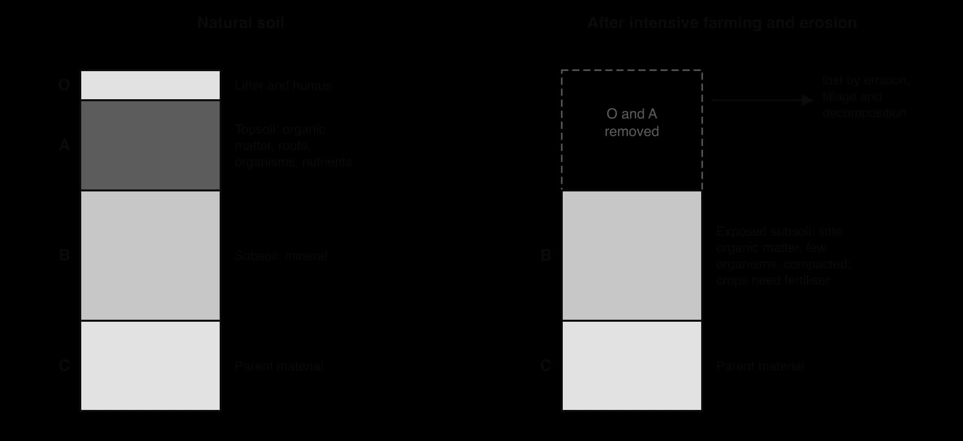
Natural soils usually have O, A, B and C horizons. In many intensively farmed fields, repeated ploughing has mixed and then lost the O horizon, and erosion and the decomposition of organic matter have thinned or removed the A horizon, so that crops grow in what was originally the B horizon. Such a soil can still produce high yields, but only with large and repeated additions of synthetic fertiliser, and it holds water poorly and erodes easily. Protecting the A horizon is therefore the central aim of sustainable soil management, and every conservation technique can be judged by how well it keeps topsoil in place and rebuilds its organic matter.
Because climate and vegetation are two of the strongest influences on soil formation, each major biome tends to have its own characteristic soils. The two classic examples are the brown earths of temperate deciduous forests and the oxisols of tropical rainforests.
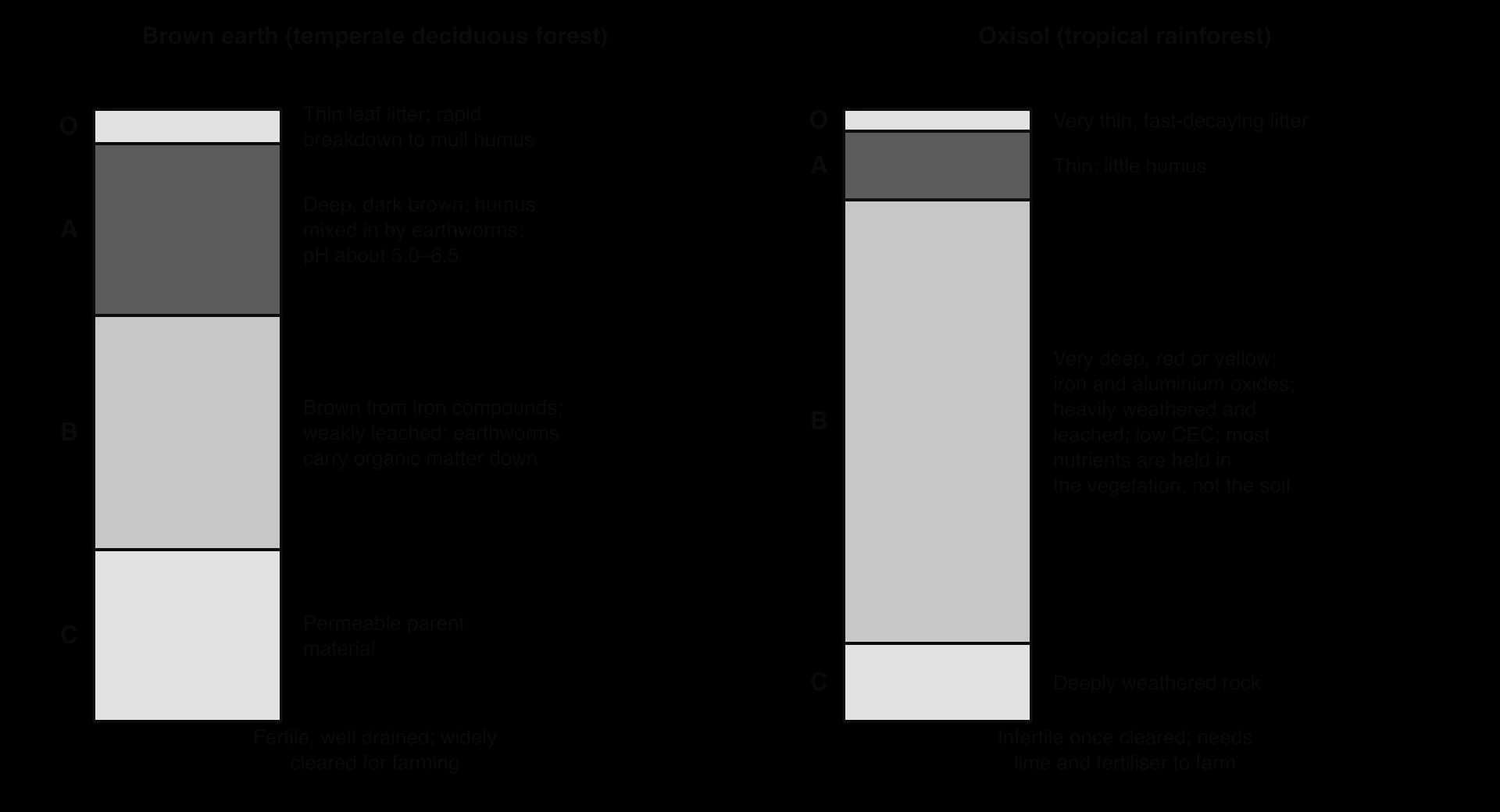
Brown earths form under deciduous woodland in humid temperate climates, mostly between about 35° and 55° N in western and central Europe; they cover about 45% of the land in England and Wales. The autumn leaf fall gives a large litter input that earthworms mix into a deep, dark A horizon of mull humus, and moderate rainfall leaches only the most soluble minerals. With a pH of about 5.0–6.5 and good drainage, they are fertile, which is why much of the original deciduous woodland was cleared for farming.
Oxisols form under tropical rainforest, mainly within about 25° of the equator in South America and Africa. Millions of years of high temperatures and heavy rainfall have weathered almost all the original minerals, leaving a deep, red or yellow soil rich in iron and aluminium oxides and the low-activity clay kaolinite. Litter decomposes so quickly that there is little humus, and the cation-exchange capacity is low, so the soil holds few nutrients. When the forest is cleared, the nutrient store in the trees is lost and the soil soon becomes infertile unless lime and fertiliser are added, as in Brazil’s large soybean farms.
Biome | Typical soil | Key features of the profile |
|---|---|---|
Tropical rainforest | Oxisol | Thin O and A; very deep, red, leached B; low CEC |
Temperate deciduous forest | Brown earth | Mull humus; deep, dark A; brown B; fertile |
Temperate grassland (steppe, prairie) | Chernozem (mollisol) | Very deep, black, humus-rich A, up to about 1.5 m; very fertile |
Boreal forest | Podzol | Acid needle litter; pale, leached E horizon; iron-rich B |
Tundra | Tundra soil on permafrost | Thin active layer; waterlogged, peaty, grey; frozen below |
Sources: Wikipedia, “Brown earth”, “Oxisol”, “Chernozem” (2026).
 YouTube
Every soil is the product of the same few soil formation factors acting together. The soil scientist Hans Jenny described them in 1941 as a set of five, still known by the initials CLORPT: climate, organisms, relief (geomorphology), parent material (geology) and time. Change any one of them and a different soil develops.
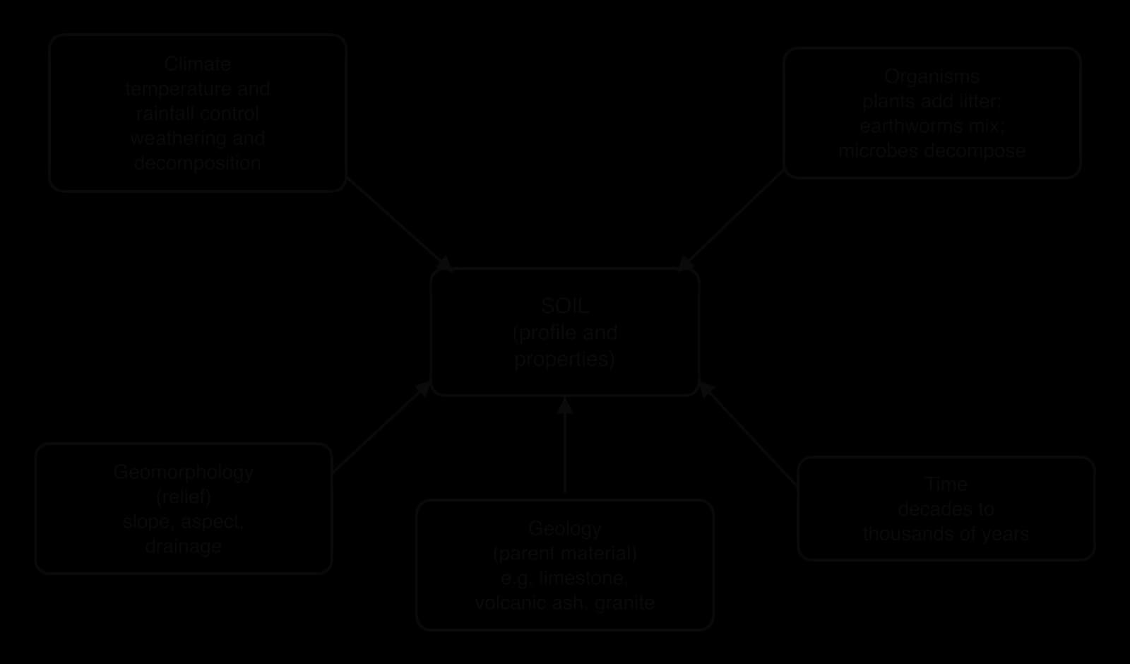
Temperature and rainfall control the speed of weathering and decomposition and the direction in which water moves. The rate of chemical reactions roughly doubles with each 10 °C rise, so long as water is available. In hot, wet tropical climates, weathering is deep, decomposition fast and leaching intense, producing deep but nutrient-poor soils such as oxisols. In temperate climates, weathering and decomposition are moderate, and humus can build up. In polar climates, both are very slow: soils are thin, organic matter accumulates on top of permafrost, and frost action churns the soil. In arid climates, evaporation exceeds rainfall, water moves upwards and salts and carbonates collect near the surface.
Vegetation determines the type and amount of litter. Broadleaved deciduous trees and grasses produce litter rich in nutrients that decomposes readily into mild humus, while conifer needles produce acidic litter that decomposes slowly and encourages leaching. Earthworms, termites and ants mix the soil; fungi and bacteria decompose litter and release nutrients; nitrogen-fixing bacteria add nitrogen. People are now among the most powerful soil-forming organisms, through ploughing, drainage, irrigation and fertiliser.
Slope: on steep slopes, soil is moved downhill by erosion and creep almost as fast as it forms, so soils are thin. Material accumulates at the foot of slopes and in valleys, where soils are deeper.
Aspect: the direction a slope faces. In the northern hemisphere, south-facing slopes receive more sunlight, so their soils are warmer and drier, with faster evaporation and different vegetation from north-facing slopes.
Drainage: on hilltops and slopes water drains away and soils are well aerated; in hollows and valley floors water collects, and soils become waterlogged, grey and rich in organic matter.
As a result, a single hillside often shows a sequence of different soils from top to bottom, even on the same parent rock.
Parent material supplies most of the minerals and nutrients in a soil and affects its texture, drainage and pH. Two contrasting examples show how strong this influence can be.
Calcareous parent rock (limestone and chalk) is mostly calcium carbonate, which dissolves in weakly acidic rainwater and leaves little residue. Soils on it are often shallow, with a dark, humus-rich topsoil lying directly on the shattered rock. These rendzinas are rich in calcium and magnesium, have a high base saturation and a pH that is often neutral or alkaline, but they are often too shallow and dry for productive farming and are commonly left as grassland.
Volcanic parent material (volcanic ash and other tephra) weathers quickly and releases many nutrients. The resulting andosols have a low bulk density and are often very fertile. They cover only about 1–2% of the world’s ice-free land, around the Pacific Ring of Fire and in places such as Iceland, Italy and the East African Rift, but on Java in Indonesia they support intensive wet-rice farming and some of the densest rural populations in the world.
Sources: Wikipedia, “Pedogenesis”, “Rendzina”, “Andosol” (2026).
Horizons develop slowly. A young soil on recent glacial deposits, a new lava flow or a landslide scar has a thin, simple profile, often just an A horizon on C. Over hundreds to thousands of years, weathering deepens the soil, organic matter accumulates and leaching builds distinct B horizons.
Sand, silt and clay differ in chemistry as well as size. Sand and silt are mostly grains of quartz (silicon dioxide), which is chemically inert and carries almost no electrical charge. Clays are complex layered silicates of aluminium, magnesium and iron. Within their crystal layers, some atoms are replaced by others of lower charge, which leaves the surface of each clay particle with a permanent negative charge. Humus also carries many negative charges on its organic molecules.
Negatively charged surfaces attract and hold positively charged ions (cations), including the plant nutrients calcium (Ca²⁺), magnesium (Mg²⁺), potassium (K⁺) and ammonium (NH₄⁺). These ions are held loosely enough to be exchanged: a root releases hydrogen ions (H⁺), which swap places with nutrient cations on the clay surface, and the released nutrients are absorbed. The capacity of a soil to hold exchangeable cations is its cation-exchange capacity (CEC).
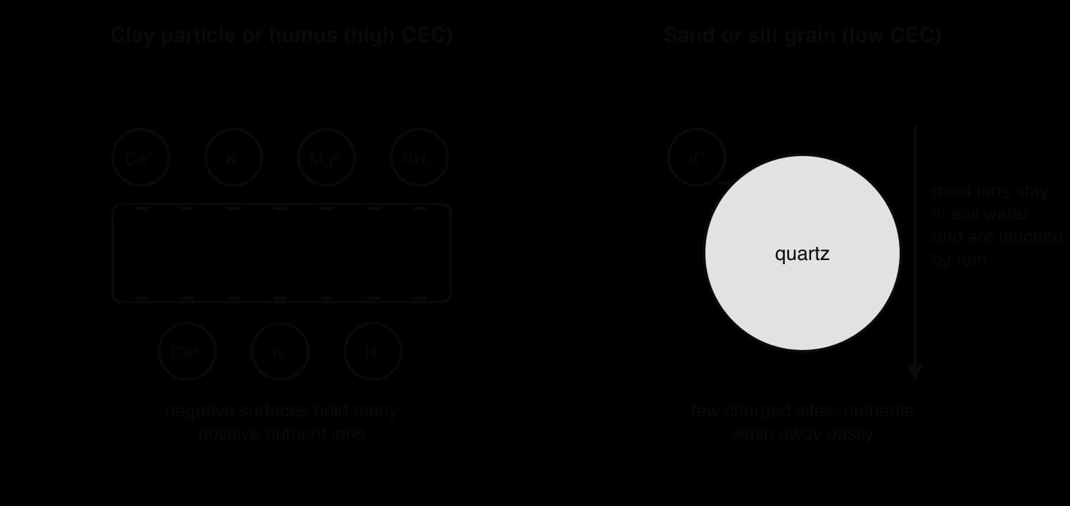
Soils with a high CEC, such as clay loams and humus-rich chernozems, can store large amounts of nutrients and resist leaching, so they stay fertile with fewer inputs. Soils with a low CEC, such as sands and highly weathered oxisols, lose added fertiliser quickly. CEC is usually measured in centimoles of positive charge per kilogram of soil (cmol kg⁻¹). Average values for different soil orders in the United States range from about 3.5 cmol kg⁻¹ in highly weathered ultisols to 18.7 in mollisols and 128 in organic histosols (peat soils).
Sources: Wikipedia, “Cation-exchange capacity” (2026).
Acidity lowers the effective CEC. In acid soils, hydrogen and aluminium ions occupy many of the exchange sites and displace calcium and magnesium, which are then leached. This is one reason why acid soils are often infertile, and why farmers add lime (calcium carbonate) to raise pH and restore the supply of calcium. Building up humus is often the most practical way to raise the CEC of a sandy or highly weathered soil.
A soil survey or an investigation usually measures several properties at once. Each one tells something about how the soil formed and what it can support.
Property | How it is measured | What it shows |
|---|---|---|
Sand, silt and clay (%) | Sedimentation or a laboratory particle-size analysis | Texture class (from the texture triangle); drainage and nutrient retention |
Organic matter (%) | Loss on ignition | Humus content, carbon storage, water and nutrient retention |
Water content (%) | Mass lost on drying at about 105 °C | Moisture at the time of sampling; with repeated samples, water retention |
Infiltration rate | Time for a measured volume of water to soak in from a ring pushed into the ground (mm per minute) | Drainage, compaction, risk of run-off and erosion |
Bulk density | Dry mass of a known volume of undisturbed soil (g cm⁻³) | Compaction and pore space: higher values mean less pore space |
Colour | Compared with a standard colour chart | Organic matter (dark), iron oxides and good drainage (red, yellow), waterlogging (grey, mottled) |
pH | pH meter or indicator in a soil–water mixture | Acidity; availability of nutrients; need for liming |
Bulk density is calculated from a core of soil of known volume, taken with a metal cylinder so that the pores are not squashed. Most mineral soils have bulk densities of about 1.1–1.6 g cm⁻³; the particles themselves have a density of about 2.6–2.7 g cm⁻³, so the difference shows how much of the soil is pore space.
The soil texture triangle turns three percentages into a single texture class. Each side of the triangle is a scale from 0 to 100% for one particle size: in the common USDA version, sand along the base, silt along the right side and clay along the left. Because the three percentages always add up to 100%, any two of them fix a single point, and the region in which the point falls gives the texture class, such as loam, silty clay or sandy loam.
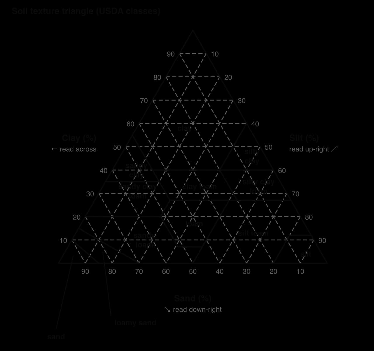
Reading the triangle needs care, because the lines for each scale run in a different direction. Clay lines run horizontally, parallel to the base. Silt lines run parallel to the left side, rising towards the right. Sand lines run parallel to the right side, rising towards the left. A sample point lies where its three lines meet.
Soils release carbon in two forms. Where oxygen is present, aerobic decomposers respire organic matter to carbon dioxide (CO₂). Where soils are waterlogged and oxygen is absent, anaerobic conditions allow microorganisms called methanogens to produce methane (CH₄), a much more powerful greenhouse gas per molecule, though it stays in the atmosphere for only about a decade. Any change that speeds up decomposition or exposes stored organic matter to air turns a soil from a store into a source.
Global warming: warmer soils decompose organic matter faster, and in cold regions thaw permafrost that has kept organic matter frozen for thousands of years.
Agriculture: ploughing aerates the soil and breaks up the crumbs that protect organic matter, and converting grassland or forest to cropland reduces litter input.
Draining wetlands: lowering the water table lets oxygen into peat, which then decomposes to CO₂ and can catch fire. In Indonesia, peat swamp forests have been drained for oil palm and pulpwood plantations, turning one of the world’s densest soil carbon stores into a large source.
Other human activity: construction, mining and the removal of topsoil expose organic matter directly.
The soils of the northern permafrost region hold an estimated 1,460–1,600 billion tonnes of organic carbon, more than twice the amount of carbon in the atmosphere. Although permafrost-affected soils cover only about 9% of Earth’s land area, they store between a quarter and a half of all soil organic carbon. As the Arctic warms faster than the global average, the active layer that thaws each summer becomes deeper and parts of the permafrost thaw completely.
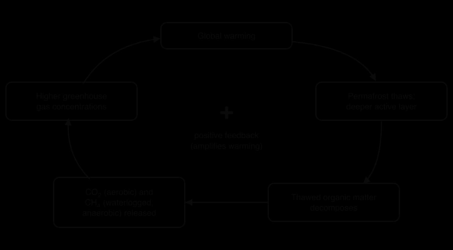
Carbon dioxide makes up the great majority of the carbon released by thawing permafrost, with methane making up a smaller share from waterlogged sites. Because the release adds to warming, which causes more thaw, it is a positive feedback. Abrupt thaw, in which ground ice melts and the land surface collapses, can expose deep carbon quickly. Permafrost thaw is often given as an example of a climate tipping point: beyond a certain amount of warming, the loss of carbon could continue for centuries even if emissions from fossil fuels stopped.
Sources: Wikipedia, “Permafrost carbon cycle” (2026), citing IPCC AR6 (2021).
Beneath permafrost and in the sediments of the continental shelves and slopes, methane is also stored as methane clathrate: a solid, ice-like substance in which methane molecules are trapped inside a lattice of frozen water. Clathrates are stable only at low temperatures and high pressures. Estimates of the carbon they hold vary widely, from about 500 to 2,500 billion tonnes, of which a few hundred billion tonnes may be in Arctic permafrost.
If rising temperatures warm the ground or seabed enough, clathrates break down and release methane. This would be a tipping point: a threshold beyond which a self-reinforcing release could continue. The scientific assessment is uncertain. The most recent assessment of the Intergovernmental Panel on Climate Change, in 2021, judged it very unlikely that methane from clathrates will substantially warm the climate over the next few centuries, because most deposits are deep and would respond only slowly, but some researchers argue that the uncertainty is too large to rule out faster release.
Explosive gas-emission craters on the Yamal and Gydan peninsulas of western Siberia, first noticed in 2013–2014, show that gas can build up under thawing permafrost and burst out. By 2020, seventeen such craters were known. Most researchers explain them by the release of gas, possibly including methane from hydrates, under pressure as the permafrost warms, although the exact mechanism is still debated.
Sources: Wikipedia, “Methane clathrate” and “Siberian craters” (2026).
Protecting soil carbon is therefore part of climate policy as well as farming policy. Keeping peatlands wet, avoiding the drainage of permafrost and wetland soils, and rebuilding organic matter in farmland all reduce the risk of soils becoming a growing source. Soil carbon also has legal, economic and ethical dimensions: payments to landowners for keeping carbon in soils are a form of payment for ecosystem services, and the costs of thawing permafrost, which fall largely on future generations, raise questions of intergenerational justice.
Soil appears in Paper 2 Section A as short questions on the soil system, profiles, texture and carbon storage, often with a calculation or a diagram to draw. In Paper 1, soil data from an unfamiliar place (texture, organic matter, infiltration, pH) are a common resource. Section B essays usually combine soil degradation with farming, land use or climate change, and reward a named case study and a clear judgement.
Questions on carbon storage often ask for the reasons behind a difference between biomes. The answer needs the balance of inputs and decomposition, and the climatic reasons for it.
The following resource describes three sites on a hillside farm in a semi-arid region. The data are hypothetical.
Site | Land use | Sand (%) | Silt (%) | Clay (%) | Organic matter (%) | Infiltration (mm min⁻¹) | Bulk density (g cm⁻³) |
|---|---|---|---|---|---|---|---|
A: hilltop | Native grassland, ungrazed | 40 | 40 | 20 | 6.2 | 12.0 | 1.15 |
B: mid-slope | Ploughed for wheat every year | 42 | 40 | 18 | 2.1 | 4.5 | 1.45 |
C: valley floor | Grazed pasture | 20 | 45 | 35 | 4.8 | 1.8 | 1.60 |
Essay questions build from description to evaluation. The last part rewards a clear argument supported by a named example and different perspectives.
HL questions often ask for the chemistry behind soil fertility, or for links between soil carbon and climate tipping points.
Soil is a mixture of mineral particles from weathered parent material, organic matter, water and air, and is an ecosystem in its own right.
The soil system has inputs (litter, weathered minerals, deposition, guano, precipitation, fertiliser, solar energy) and outputs (decomposition to CO₂, root uptake, leaching, evaporation, erosion, heat loss).
Transfers move material (infiltration, percolation, biological mixing, aeration, leaching, erosion); transformations change it (decomposition, weathering, nutrient cycling, salinisation).
Soils develop a profile of horizons, from organic-rich layers at the surface to inorganic, weathered parent material below; loss on ignition measures their organic matter.
Soils supply water and almost all plant nutrients (not carbon), are home to perhaps 59% of species, and recycle elements through detritivores and saprotrophs.
Soil texture, the proportions of sand, silt and clay, controls nutrient and water retention, drainage and aeration, and so primary productivity; humus improves every texture.
Soils are carbon sinks, stores or sources depending on litter input against decomposition; tundra, wetland and temperate grassland soils store far more carbon than tropical forest soils.
Erosion, salinisation, compaction, nutrient loss and pollution degrade soils; on the Loess Plateau, terracing and revegetation reversed severe erosion but face water limits.
Soils are classified by their profile: O, A, B and C horizons; brown earths under temperate deciduous forest, oxisols under rainforest; the A horizon is the most valuable and most vulnerable. (HL)
Climate, organisms, geomorphology, geology (such as calcareous or volcanic rock) and time control soil formation. (HL)
Clay and humus have a high cation-exchange capacity; soil data and the texture triangle classify soils. (HL)
Warming, farming and drainage release soil carbon as CO₂ or CH₄; thawing permafrost and methane clathrates are possible tipping points. (HL)
I can describe the components of soil and where each comes from.
I can outline the inputs, outputs, transfers and transformations of a soil system.
I can construct a soil systems diagram and label each flow as a transfer or a transformation.
I can describe a soil profile and calculate organic matter and water content from sample data.
I can explain how soils support plant growth, biodiversity and the recycling of elements.
I can explain how texture and humus affect nutrients, water, aeration and productivity.
I can explain why a soil may be a carbon sink, store or source, and compare biomes.
I can evaluate the causes of soil degradation and its reversal, using the Loess Plateau.
I can classify soils from profile diagrams and explain why the A horizon matters. (HL)
I can explain the five factors of soil formation, including calcareous and volcanic rock. (HL)
I can explain cation-exchange capacity and use the soil texture triangle. (HL)
I can discuss soil carbon release, permafrost and methane clathrates as possible tipping points. (HL)