Explain how communities change along environmental gradients and over time, investigate zonation with transects and kite diagrams, and evaluate succession, climax and plagioclimax using Surtsey and other examples.
Each is in the ESS glossary, with every other term in the subject.
The relatively stable community at the end of a succession, in steady-state equilibrium with the climate and soils of the area.
The arrival and establishment of a species in an area where it did not previously live, for example plants spreading onto newly exposed rock.
The drying out of an organism or a habitat through loss of water, a major stress for organisms exposed to air at low tide or on dry soils.
An event, natural or human, such as fire, flood, storm, grazing or clearing, that removes or damages part of a community and changes the resources available.
A transition zone between two communities or biomes, where species from both occur and the community changes along an environmental gradient.
A gradual change in one or more abiotic factors, such as temperature, exposure or soil moisture, across a distance in space.
A process in succession in which one species changes the conditions, for example by adding nitrogen or organic matter to the soil, in a way that helps other species to establish.
Outline what zonation is and explain how changes in abiotic factors along an environmental gradient produce it.
Describe how transects are used to investigate zonation, and construct and interpret kite diagrams.
Distinguish between zonation and succession.
Explain how each seral community changes conditions so that it is replaced, from pioneer to climax community.
Distinguish between primary and secondary succession, using named examples.
Explain how energy flow, productivity, species diversity, soil depth and nutrient cycling change during succession.
Discuss the links between diversity, resilience, stability, succession and human disturbance.
Explain how climate, bedrock, soil, relief, fire and top-down influences shape the community that develops. (HL)
Explain the changes in gross productivity, net productivity and respiration during succession, and the roles of r- and K-strategists. (HL)
Evaluate the climax community concept, including the Vera hypothesis and alternative stable states. (HL)
Explain how human activity can divert succession to produce a plagioclimax. (HL)
Communities are not fixed. Walking up a mountain or down a rocky shore, the plants and animals change from place to place; leaving a field unploughed, they change from year to year. The first kind of change, across space, is zonation; the second, through time, is succession. Together they explain much of the variety seen in the countryside and how damaged ecosystems recover.
Both are processes in systems: abiotic and biotic factors interact, and the community alters its own environment through
The official deck for this part of the syllabus.
What is zonation?
What is an environmental gradient?
With a free account, Augment remembers where you stopped and what you have practiced.
A graph that shows how the abundance of each species changes along a transect, with the width of each band proportional to its abundance at each point.
The first community to become established on a newly exposed or disturbed surface at the start of succession, made up of pioneer species.
A species that is first to colonise bare ground or rock, able to tolerate harsh conditions such as lack of soil, nutrients and water, and often an r-strategist.
A stable community that develops when human activity, such as burning, grazing or mowing, stops or diverts succession before the climatic climax is reached.
The identification and counting of pollen grains preserved in layers of peat or lake sediment, used to reconstruct past vegetation and the changes of succession.
Succession on a newly formed surface with no soil and no previous community, such as new volcanic rock, a glacial moraine, wind-blown sand or freshly deposited silt.
Succession on bare soil where a community existed before but was removed or destroyed, for example abandoned farmland or forest after a severe fire.
One of the series of communities, or seral stages, that replace each other during succession, from the pioneer community to the climax community.
The replacement of one community by another in an area over time, as each community changes the biotic and abiotic conditions so that others can colonise and outcompete it.
The regulation of a community by organisms at higher trophic levels, such as predators or large herbivores, which limits the abundance of the organisms they eat.
The hypothesis, proposed by Frans Vera in 2000, that large wild herbivores kept much of lowland temperate Europe as a mosaic of open grassland, scrub and woodland rather than closed forest.
The change in community composition along an environmental gradient, such as altitude, latitude, tidal level or distance from a water source.
Along many lines across the land, one or more abiotic factors change gradually: temperature falls with height up a mountain, exposure to air increases up a seashore, soil moisture falls with distance from a river. Such a gradual change is an environmental gradient. Because each species can survive only within its own range of tolerance, the community changes along the gradient, and species are arranged in bands or zones.
Zonation is a pattern in space, so it can be seen at a single moment by walking along the gradient that produces it.
The boundary between two zones is rarely a sharp line. Species from both zones overlap in a transition area called an ecotone, where the community changes most rapidly. Ecotones can be richer in species than either zone on its own, because they contain species from both (the edge effect).
Two kinds of factor set the limits of each zone. Abiotic factors set the limits a species can tolerate: at the edge of its range of tolerance it cannot survive, grow or reproduce. Biotic factors, especially competition and predation, decide where within that range a species actually lives. A species may be able to tolerate a wide range of conditions but be excluded from the more favourable part by a stronger competitor or by a predator, so its realised niche is narrower than its fundamental one.
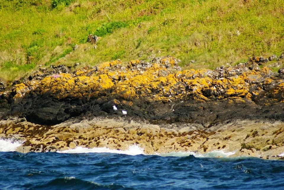
Rocky shores show this clearly. In general, the upper limit of each species on the shore is set by its tolerance of desiccation and temperature change when exposed to air at low tide, while its lower limit is often set by competition or predation from species that live lower down.
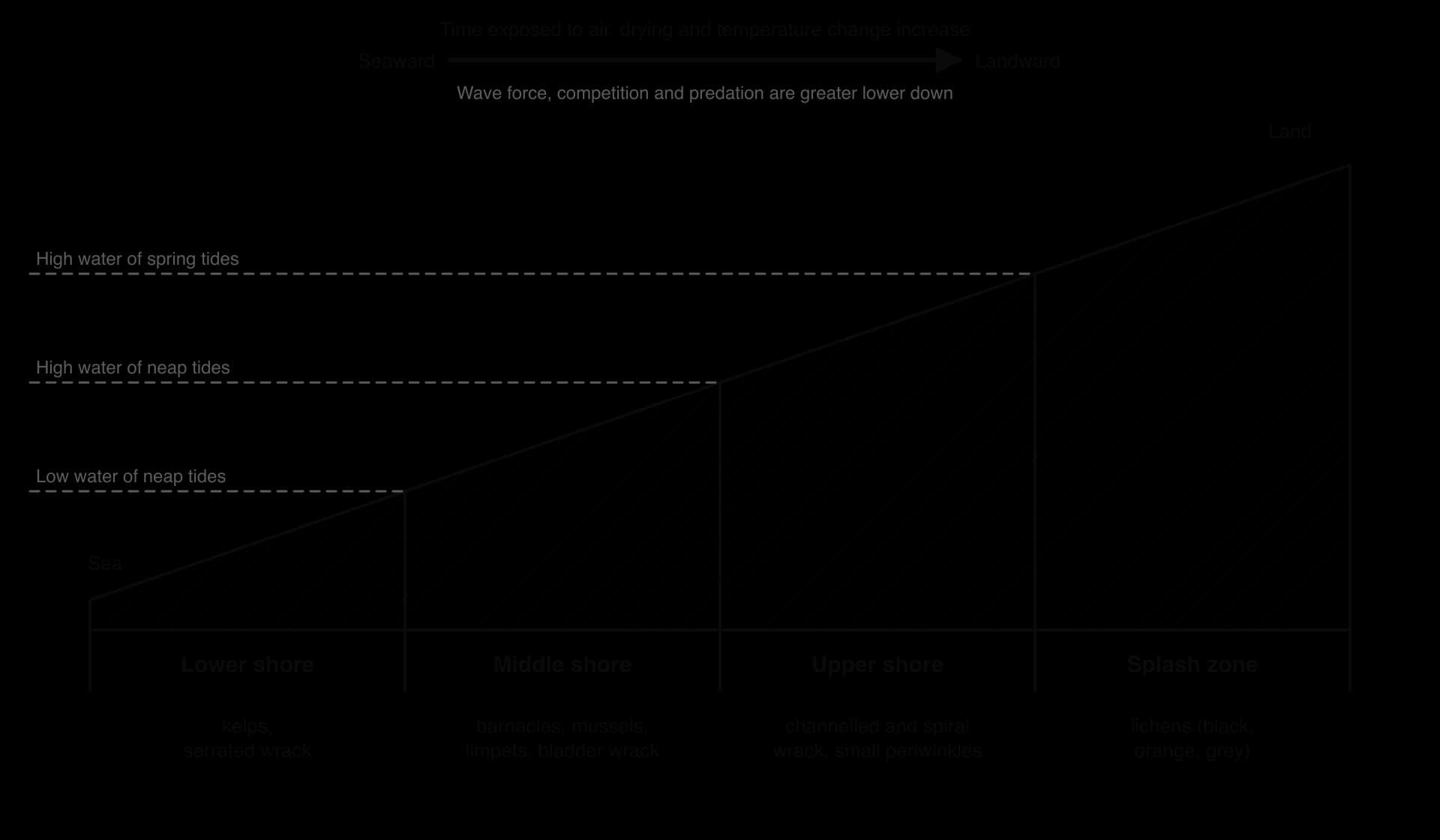
On a rocky shore, the tide covers and uncovers the rock twice a day. Rock near the top of the shore is covered by the sea for only a short time and exposed to the air, sun, wind, rain and frost for long periods; rock near the bottom is almost always under water. This gradient in exposure produces some of the clearest zonation in nature.
Splash zone: above the reach of normal tides, wetted only by spray. Lichens of black, orange and grey colours cover the rock.
Upper shore: covered only at high tide. Brown seaweeds such as channelled wrack and spiral wrack, which can lose much of their water and recover, and small periwinkles.
Middle shore: covered and uncovered every tide. Barnacles, mussels and limpets cover the rock, with bladder wrack.
Lower shore: uncovered only at the lowest tides. Serrated wrack and, at the water's edge, large kelps that cannot tolerate drying out but compete strongly for light underwater.
 YouTube
On a mountain, temperature falls with height, and precipitation, wind speed, soil depth and the length of the growing season also change. The result is a sequence of vegetation zones that resembles, on a small scale, the change in biomes from the equator to the poles. Mount Kilimanjaro in Tanzania, at 5,895 m the highest mountain in Africa, rises from farmland and savanna through montane forest to heath, alpine zones and ice.
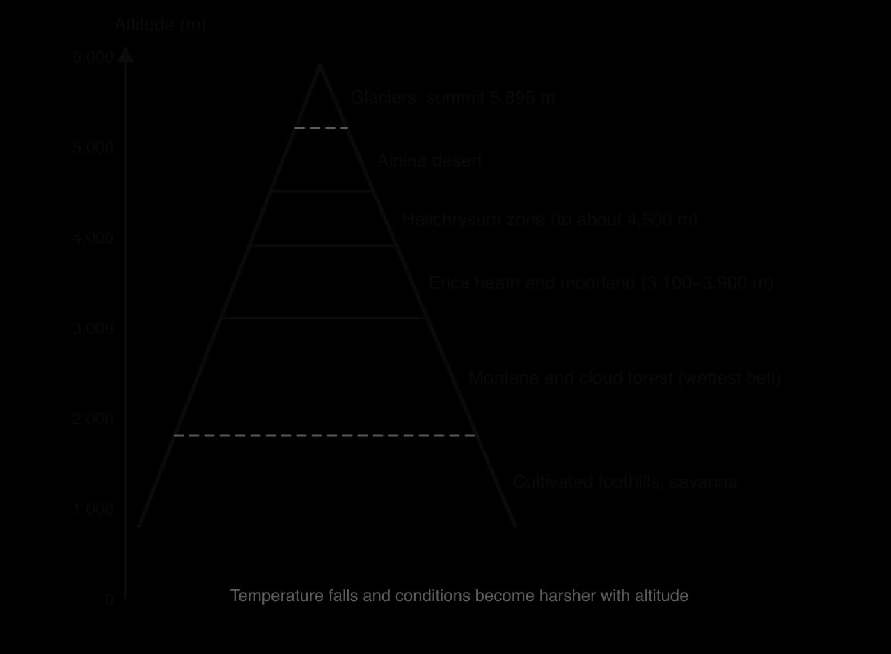
Pollen records from the mountain show that these zones have moved in the past: between about 42,000 and 30,000 years ago, when conditions were colder and drier, the belt of heath vegetation lay about 1,500 m lower than today. Zonation on mountains is therefore sensitive to changes in climate, which is why mountains are used to detect the effects of global warming.
Latitude: the sequence of biomes from equator to pole is zonation on a global scale.
Distance from water: around a lake or along a river bank, plants change from submerged and floating plants, to reeds rooted in shallow water, to marsh plants, to woodland on drier ground, following the gradient in waterlogging.
Soil horizons: within a soil profile, the organisms change with depth, as oxygen, organic matter and light decrease: plant roots and most animals are concentrated in the upper, organic-rich horizons.
Distance from a source of disturbance: around a footpath or a pollution source, communities change with the intensity of trampling or pollution.
To find out which variables affect the distribution of species along a gradient, samples are taken systematically along a transect: a line laid out across the gradient, at right angles to the zones. Because the aim is to see how the community changes with the gradient, the sampling points are spaced at regular intervals, not chosen at random.
Line transect: every organism touching a tape stretched across the gradient is recorded at regular intervals. Quick, but it misses species that are not on the line.
Belt transect: a quadrat is placed at regular intervals (continuous or interrupted) along the line, and the abundance of each species is recorded as percentage cover, percentage frequency or a count. Slower, but it gives quantitative data.
At each sampling point, the relevant abiotic factors are measured as well, so that changes in the community can be related to them. On a rocky shore this means height above low water (which sets exposure time), wave exposure, rock-pool temperature and salinity; on a sand dune, soil moisture, pH, organic content (by loss on ignition), wind speed and distance from the sea; on a mountain, altitude, temperature, soil depth and light.
Identify the environmental gradient and decide the start and end points (for example from the strandline to the woodland behind a dune system).
Lay a tape along the gradient, at right angles to the zones.
Choose a sampling interval that will show the changes (for example every 10 m on a dune or every 0.5 m of height on a shore) and record it.
At each point, place a quadrat and record the percentage cover of each species, using an identification key or app.
At each point, measure the abiotic factors with the same method and equipment each time.
Repeat with two or more parallel transects to check that the pattern is not a result of one unusual line.
Leave the site as it was found, avoid trampling sensitive vegetation and return organisms to where they were found.
In a kite diagram, distance along the transect is plotted on the horizontal axis, and each species has its own horizontal line. At each sampling point, the abundance is drawn as a width centred on the species' line: half above it and half below. Joining the points produces a kite-shaped band that widens where the species is abundant and narrows to nothing where it is absent.
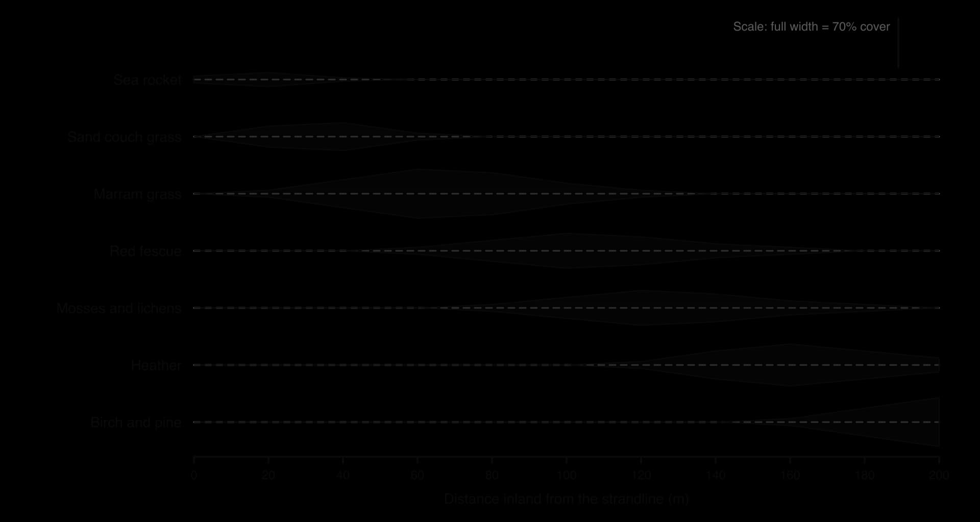
Reading the dune diagram from left to right shows how the community changes with distance from the sea: pioneer species such as sea rocket and sand couch grass near the shore, marram grass on the mobile dunes, red fescue, mosses and lichens on the fixed dunes, heather on the older dunes, and trees furthest inland. Because the dunes furthest from the sea are also the oldest, this zonation in space also records a succession in time.
Sources: Wikipedia, "Mount Kilimanjaro" (zones and pollen record); generalised shore and dune species from field guides; kite diagram data hypothetical.
When bare ground appears, after a volcanic eruption, a retreating glacier or the end of farming, it does not stay bare. A sequence of communities colonises it (colonisation), each changing the conditions in a way that allows the next to establish. This orderly change over time is succession.
Succession can take hundreds of years, far longer than any single study. Ecologists therefore reconstruct it in several ways: by returning to the same permanent plots for decades, by studying places of known age side by side (a chronosequence, such as dunes or moraines of increasing age), by using old maps, aerial photographs and satellite images, and by reading the record of past vegetation preserved in peat and lake sediments.
Pollen analysis depends on the fact that pollen grains have a tough outer wall that resists decay, especially in the waterlogged, acidic, oxygen-poor conditions of a peat bog. Each year a little pollen falls onto the bog and is buried as the peat grows upwards, so a core drilled through the peat contains a sequence of layers, oldest at the bottom. Because pollen grains of different plants have different shapes, the proportions of each type in each layer show which plants grew nearby at that time. Radiocarbon dating of the peat gives the age of each layer.
Pollen diagrams from northern Europe record the succession that followed the retreat of the ice at the end of the last glaciation: an early tundra-like community of grasses, sedges and dwarf shrubs, followed by birch and pine woodland, then hazel, and eventually mixed deciduous woodland with oak, elm and lime. The same records also show later changes, such as forest clearance by early farmers.
Each community in the sequence is called a seral stage or sere. The first community is the pioneer community, made up of pioneer species that can survive in harsh conditions: no soil, few nutrients, little water, strong sun and wind. The final, relatively stable community is the climax community.
On bare rock, the sequence typically runs as follows.
Pioneer stage: lichens and mosses colonise the rock. Lichens release weak acids that slowly break down the rock surface, and mosses trap wind-blown dust. When they die, their remains add organic matter. Together these processes begin soil formation.
Early seral stages: the thin soil now holds some water and nutrients, so grasses and small herbs can grow. Their roots break up the rock further, and their dead remains thicken the soil and add humus.
Mid seral stages: deeper, moister soil supports taller herbs and shrubs, which shade out the low-growing pioneers.
Late seral stages: fast-growing, light-demanding trees such as birch establish and overtop the shrubs.
Climax: slower-growing, shade-tolerant trees such as oak (in lowland western Europe) eventually dominate, and the community changes little while the climate stays the same.
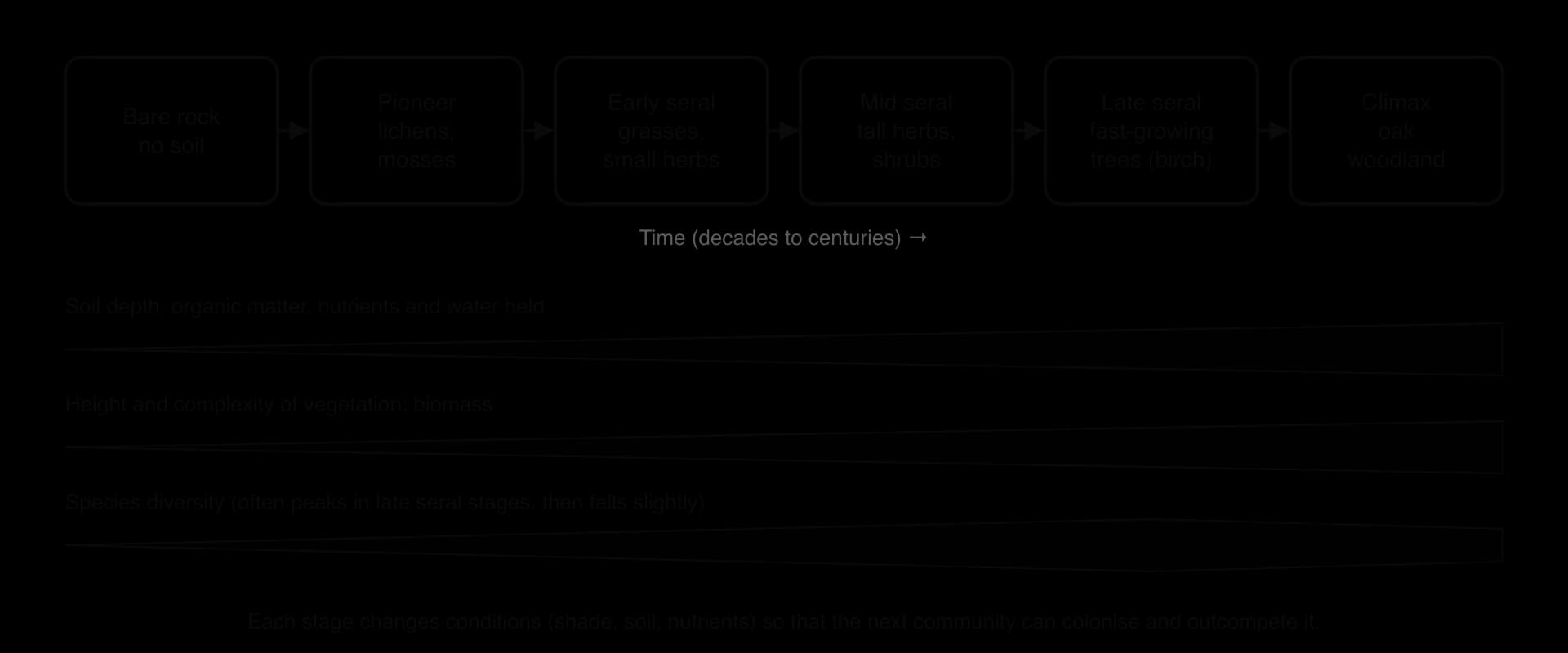
Three processes drive the sequence. Facilitation: each community changes conditions in ways that help later species, for example by building soil or adding nitrogen. Competition: the later species are larger or more shade-tolerant, so they outcompete the earlier ones for light, water and nutrients. Tolerance and inhibition: some later species simply tolerate the changed conditions better, while some early species can slow the arrival of others for a time.
A climax community is in steady-state equilibrium: energy and matter continue to flow through it, but inputs and outputs are balanced, so its overall structure stays roughly constant. Individual trees die and are replaced, often by the same species, in gaps in the canopy. The climax is not unchanging; a severe disturbance such as fire or a storm can set succession back to an earlier stage.
Primary succession starts from nothing: there is no soil, no seed bank and no organic matter, so every organism must arrive from elsewhere by wind, water or animals. It is usually slow, because soil must be built before most plants can grow.
Glacier Bay in south-east Alaska is a classic example: in 1794 the bay was filled with ice, but by 1916 the ice had retreated about 105 km, the fastest documented glacier retreat, exposing a series of moraines of known age. Moving from the newest moraines near the ice to the oldest at the mouth of the bay shows a chronosequence from bare ground through nitrogen-fixing alder thickets to spruce and hemlock forest.
Secondary succession is faster than primary succession because the soil is already present, with its nutrients, organic matter and soil organisms, and often a bank of seeds and roots that survived the disturbance. Grasses and herbs can appear within a year and shrubs within a few years.
The Broadbalk Wilderness at Rothamsted, England, is one of the longest-running studies of secondary succession. The site, about 0.2 ha, had grown winter wheat every year since 1843; the last crop was sown in autumn 1881 and never harvested. In 1882 the area was fenced off and left alone, with no cultivation, fertiliser or harvesting.
Without cultivation, wild plants replaced the wheat, and the site has since become deciduous woodland, now dominated by ash, with sycamore and hawthorn. From 1900, half of the site has had all woody plants removed every year, and part of that half was grazed by sheep from 1960 to 2000 and has been mown since, so the ungrazed woodland can be compared with open vegetation held at an earlier stage. Between 1881 and 1999 the regenerating woodland gained about 3.39 tonnes of carbon per hectare per year: 0.54 t in the soil and an estimated 2.85 t in trees and roots.
Feature | Primary succession | Secondary succession |
|---|---|---|
Starting surface | New substratum with no soil (lava, moraine, sand, silt) | Existing soil after a community was removed |
Seed bank and soil organisms | None; all colonists arrive from outside | Usually present |
Nutrients and organic matter | Very low at first | Already present |
Pioneers | Lichens, mosses, nitrogen-fixing plants | Fast-growing annual weeds and grasses |
Speed | Slow (centuries to reach woodland) | Faster (decades to reach woodland) |
Examples | Surtsey (from 1963); Glacier Bay moraines | Broadbalk Wilderness (from 1882); forest after fire |
Mount St Helens in Washington State, United States, shows both types side by side. The eruption of 18 May 1980 buried some areas under thick pumice and ash, creating new surfaces for primary succession, while in other areas the blast passed overhead and left the topsoil, seeds and roots, so vegetation returned much faster. Its study gave rise to the idea of biological legacies: the survivors, organic debris and soil left after a disturbance strongly influence how quickly and in what direction the community recovers.
 YouTube
As succession proceeds, the community does not only change its species; the ecosystem as a whole changes in predictable ways.
Property | Early succession (pioneer, early seral) | Late succession (late seral, climax) | Reason |
|---|---|---|---|
Soil depth and organic matter | Little or no soil; low organic matter | Deep soil with much humus | Weathering plus the accumulation of dead organic matter over time |
Water held by soil | Low | High | Humus and fine particles hold water |
Nutrient cycling | Few nutrients, mostly from outside (rain, dust, birds); easily lost | Large stores in soil and biomass, recycled within the system; little lost | Decomposers and deep roots retain and recycle nutrients |
Biomass | Low | High | Larger, longer-lived organisms accumulate biomass |
Energy flow and food webs | Short food chains; few trophic levels | Complex food webs; more energy flows through decomposers | More species and more niches |
Species diversity | Low | High, often peaking in late seral stages | More niches and habitats; at climax a few dominant species may reduce diversity slightly |
Productivity | Low gross productivity; most of it stored as new biomass | High gross productivity, but most used in respiration | Discussed further in the HL section on productivity |
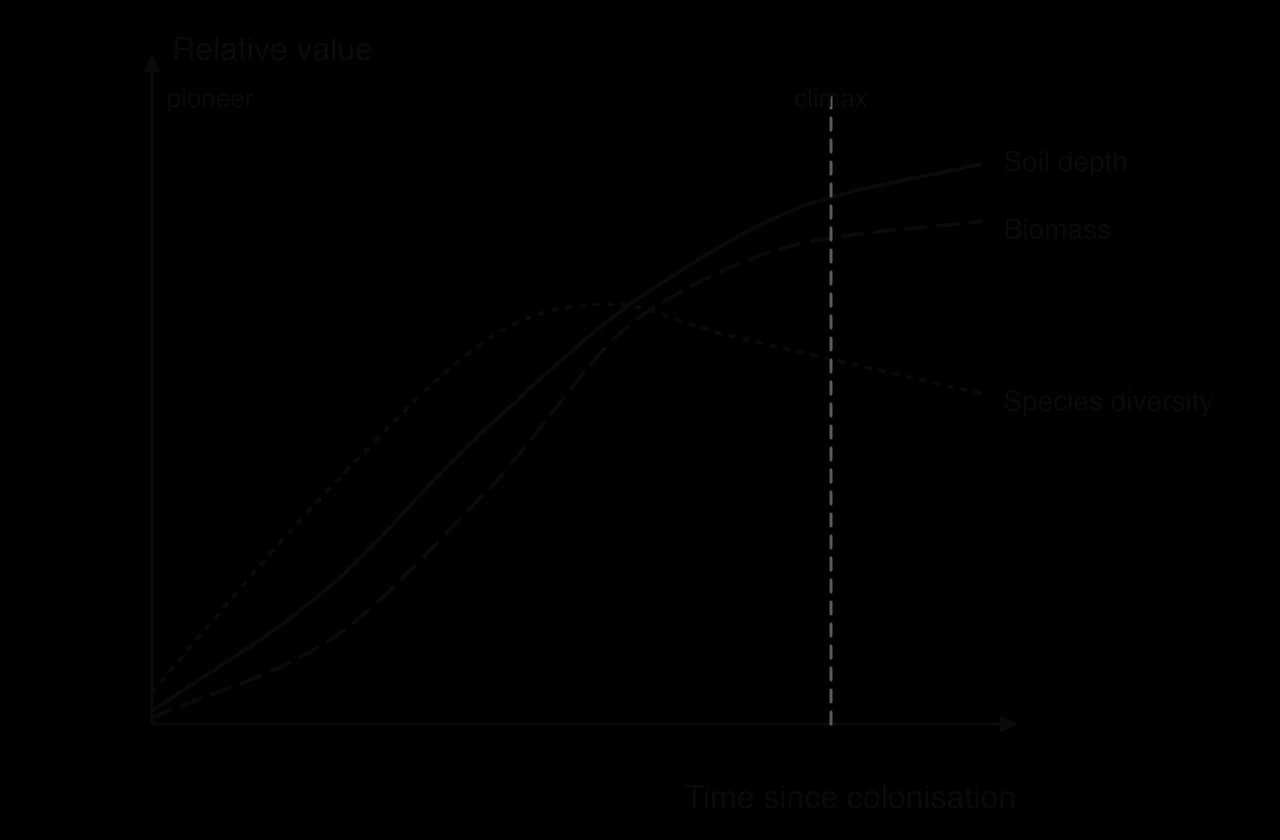
The nutrient cycle changes from open to more closed. Early on, nutrients arrive mainly from outside the system, for example in rain, wind-blown dust or the droppings of birds, and much is lost again because there is little soil or vegetation to hold it. Later, most nutrients are stored in the soil and biomass and are recycled within the ecosystem through decomposition and uptake by roots, so losses are small. Nitrogen-fixing organisms, such as lupins on Mount St Helens or alder at Glacier Bay, can speed up the early stages by adding nitrogen.
An ecosystem's capacity to tolerate disturbance and maintain its equilibrium depends on its diversity and its resilience, its capacity to resist damage and to recover from or adapt to disturbance. As succession proceeds, diversity tends to rise, food webs become more complex, and stores of nutrients, water and organic matter become larger. These changes generally make later-stage ecosystems more resilient and more stable.
More species, more ways to respond. In a diverse community, several species often carry out similar roles. If a drought, pest or disease removes one, others can take its place, so processes such as photosynthesis and nutrient cycling continue.
More complex food webs. A consumer with many food sources is less affected by the loss of one prey species than a consumer in a simple food chain.
Larger storages. Deep soils with much organic matter hold water and nutrients, buffering the community against dry years; large biomass stores buffer it against short-term disturbance.
Field experiments support the link. In long-term grassland plots at Cedar Creek in Minnesota, United States, the primary productivity of plots with more plant species was more resistant to, and recovered more fully from, a major drought than that of species-poor plots, and each species lost had a progressively greater effect on drought resistance.
The relationship is not simple. Some low-diversity systems are very resilient: grasslands and some boreal forests recover quickly after fire because their species are adapted to it. A highly diverse but slow-growing climax forest may resist small disturbances well but take centuries to recover from clearance. Human activity often reduces resilience by lowering diversity (monocultures, removal of top predators), shrinking storages (soil erosion, removal of biomass) and fragmenting habitats, which can push an ecosystem past a tipping point into a different state.
Because succession is predictable, people can choose to let it run, to speed it up, or to stop it. Many valued landscapes, such as heathland, chalk grassland and hay meadows, are not climax communities and would turn into scrub and woodland if left alone. Deciding which stage to manage for is a question of values as well as science.
Perspective | View of succession | Example of management |
|---|---|---|
Ecocentric | Natural processes should be allowed to run with minimal interference; species have intrinsic value | Leave abandoned land to regenerate naturally (natural regeneration, rewilding) |
Anthropocentric | Manage for the services and products people want | Hold land at a productive stage by grazing or cutting; plant trees to store carbon |
Technocentric | Use technology and management to direct the outcome | Plant nitrogen-fixing species and spread seed or soil on mine spoil to speed up restoration |
Cultural and traditional | Landscapes shaped by long-standing practices have cultural and biodiversity value | Maintain hay meadows, heathland or burned grasslands by traditional cutting, grazing or burning |
Sources: Rothamsted Research e-RA, Broadbalk Wilderness experiment and dataset doi:10.23637/KeyRefOABKWoc; Tilman, D. and Downing, J. A. (1994) Nature 367: 363–365; Wikipedia, "Glacier Bay National Park and Preserve", "Mount St. Helens" and "Ecological succession", with their references.
Surtsey is a volcanic island in the Vestmannaeyjar archipelago off the south coast of Iceland. It was formed by an eruption that began about 130 m below sea level; the new island reached the surface on 14 November 1963, and the eruption ended on 5 June 1967, when the island covered 2.7 km². Because the date at which the bare surface appeared is known exactly, and because the island has been protected and studied ever since, Surtsey is one of the best natural laboratories in the world for primary succession.
The island was declared a nature reserve in 1965, while the eruption was still going on. Only a small number of scientists are allowed to land, and visitors check themselves and their belongings for seeds before arriving; a tomato plant that grew from improperly managed human waste was removed. Surtsey became a UNESCO World Heritage Site in 2008 for its scientific value.

Pioneers arriving by sea (1964–1970s): flying insects were found in 1964. The first vascular plant, sea rocket (Cakile arctica), grew on the north shore in spring 1965 from seeds washed up by the sea. The first mosses were recorded in 1967 and the first lichens on the lava in 1970.
A slow start: in the first 20 years, 20 species of plant were recorded, but only 10 became established in the nutrient-poor sandy and lava surfaces. Lack of nitrogen and other nutrients, not lack of seeds, limited succession.
Seabirds as an input of nutrients (1970 onwards): northern fulmars and black guillemots began nesting in 1970. A colony of gulls established in 1984, and after about 1985 birds became the main route by which new plant species arrived, carrying seeds and fertilising the ground with their droppings.
Soil life and woody plants (1990s): the first earthworm was found in a soil sample in 1993, and the first bush, a tea-leaved willow, in 1998.
By 2013: 69 species of vascular plant had been found on the island, of which 59 were present in 2013 and 39 had formed viable populations. Since 2007 the island has had a net loss of species.
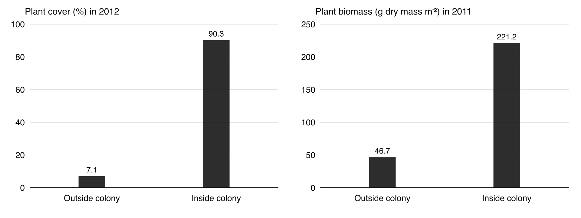
Since 1990, permanent plots have been monitored both inside the gull colony and on similar surfaces outside it. The comparison shows how strongly an outside input of nutrients changes the course and speed of succession.
Measure (mean per plot) | Outside the gull colony | Inside the gull colony |
|---|---|---|
Gull nests (per 1,000 m², 2003–2012) | 0.01 | 3.9 |
Plant cover (%, 2012) | 7.1 | 90.3 |
Plant species richness (per plot, 2012) | 4.4 | 7.7 |
Plant diversity, Shannon index in 2012 | 0.5 | 1.0 |
Plant biomass (g dry mass m⁻², 2011) | 46.7 | 221.2 |
Soil carbon (% in top 10 cm, 2008) | 0.05 | 1.84 |
Invertebrate species richness (2002–2006) | 14.2 | 28.3 |
The gulls carry nutrients from the sea to the land. Inside the colony, the ground has developed a dense grassland with far more plant cover, biomass, soil carbon and invertebrate species, while areas with few birds remain almost barren lava and sand more than 40 years after the eruption. On Surtsey, the supply of nutrients, rather than the arrival of seeds, controls the rate of primary succession.
The main management decision on Surtsey has been to exclude people almost entirely, so that colonisation happens without human introductions. This is unusual: most nature reserves are managed actively. Here the scientific value of an undisturbed "natural experiment" was judged to outweigh any use of the island for tourism or other purposes. The island has also been allowed to erode naturally, and by 2012 it had lost about half its area, shrinking to 1.3 km² as waves wore away its softer margins.
Where is the succession heading? After 2000, the oldest part of the gull colony became dominated by long-lived grasses that spread by underground stems (Festuca, Poa and Leymus), and species richness and diversity there began to fall. The neighbouring island of Elliðaey, with a large puffin colony, has a dense but species-poor grassland of the same kind. The researchers predict that Surtsey will develop a lush, species-poor grassland rather than a diverse woodland, which shows that the most mature stage need not be the most diverse.
What climax? Erosion, salt spray, wind and the heavy input of nutrients from seabirds mean that Surtsey is unlikely to follow the textbook sequence to forest. The final community depends on local factors as much as on the regional climate, which supports the view that there is no single climax for a climate.
How typical is it? Surtsey is small, isolated by sea and newly formed, so its colonists are limited to species that can cross the ocean. Results from it cannot simply be applied to succession on continents, such as on a glacier foreland, where colonists arrive from nearby. Yet it has more than twice as many plant species as similar neighbouring islands, and all of their common species have reached it.
Perspectives: scientists value the island as a reference site where succession can be observed without human influence. An ecocentric view supports leaving it alone; an anthropocentric view might see a lost opportunity for tourism or other use, but the long-term scientific return from protection is widely accepted.
Surtsey illustrates primary succession on a new substratum with no soil: pioneers (sea rocket, mosses, lichens) colonise first, soil forms slowly, and later seral stages need nutrients and organic matter to establish. It shows how an external input, here seabird guano, can speed succession and change its direction, and how soil depth, biomass, nutrient storage and diversity increase as succession proceeds. It also challenges a simple view of the climax: the community that develops reflects local conditions, and the most mature stage may be less diverse than earlier ones.
Sources: Magnússon, B. et al. (2014) "Plant colonization, succession and ecosystem development on Surtsey with reference to neighbouring islands", Biogeosciences 11: 5521–5537; Wikipedia, "Surtsey", with its references.
Climate sets the broad direction of succession, but local factors decide the community that actually develops at a particular site. The same climate can support woodland on one slope and bog or grassland on another.
Climate: temperature and precipitation set which species can grow at all, and so the general type of climax (forest, grassland, tundra).
Bedrock and soil: the parent rock controls the chemistry of the soil. Serpentine soils, formed from ultramafic rocks, have a low ratio of calcium to magnesium, few nutrients and high concentrations of metals such as nickel and chromium; only specially tolerant plants grow on them, producing an unusual, often open community. Chalk and limestone give thin, alkaline soils; sandstone gives acidic, nutrient-poor soils.
Geomorphology (landforms): steep slopes lose soil downhill and stay thin and dry; flat, low-lying ground with poor drainage becomes waterlogged, so bogs or fens develop instead of woodland.
Fire and weather events: regular fires, storms and floods reset succession or favour fire-tolerant species, so communities such as savanna, heathland and some pine forests are maintained by disturbance.
Top-down influences: consumers can control the community from above. This is top-down control: large herbivores eat or trample seedlings, and predators control the numbers and behaviour of herbivores.
In Yellowstone National Park, United States, wolves were eliminated by 1926; elk numbers then rose and heavy browsing held back aspen, cottonwood and willow. After wolves were reintroduced in 1995, elk on the northern range fell from 16,791 to 8,335 by 2004 while wolves there increased from 21 to 106. Willows recovered in places, and beaver colonies rose from one in 2001 to nine by 2011.
This is often presented as a trophic cascade. Bear predation, hunting outside the park, severe winters and drought also reduced elk in the same period, however, so scientists still debate how much of the change in the plant community is due to wolves. The case is evidence that top-down influences can shape the community that develops, alongside other factors acting at the same time.
African bush elephants feed on woody plants and often uproot trees, which can turn woodland into grassland and, together with fire, helps to keep savannas open. Where elephant numbers are high, as in Kruger National Park in South Africa, woodland can be lost, and managers have tried to control the population to protect the vegetation and other species.
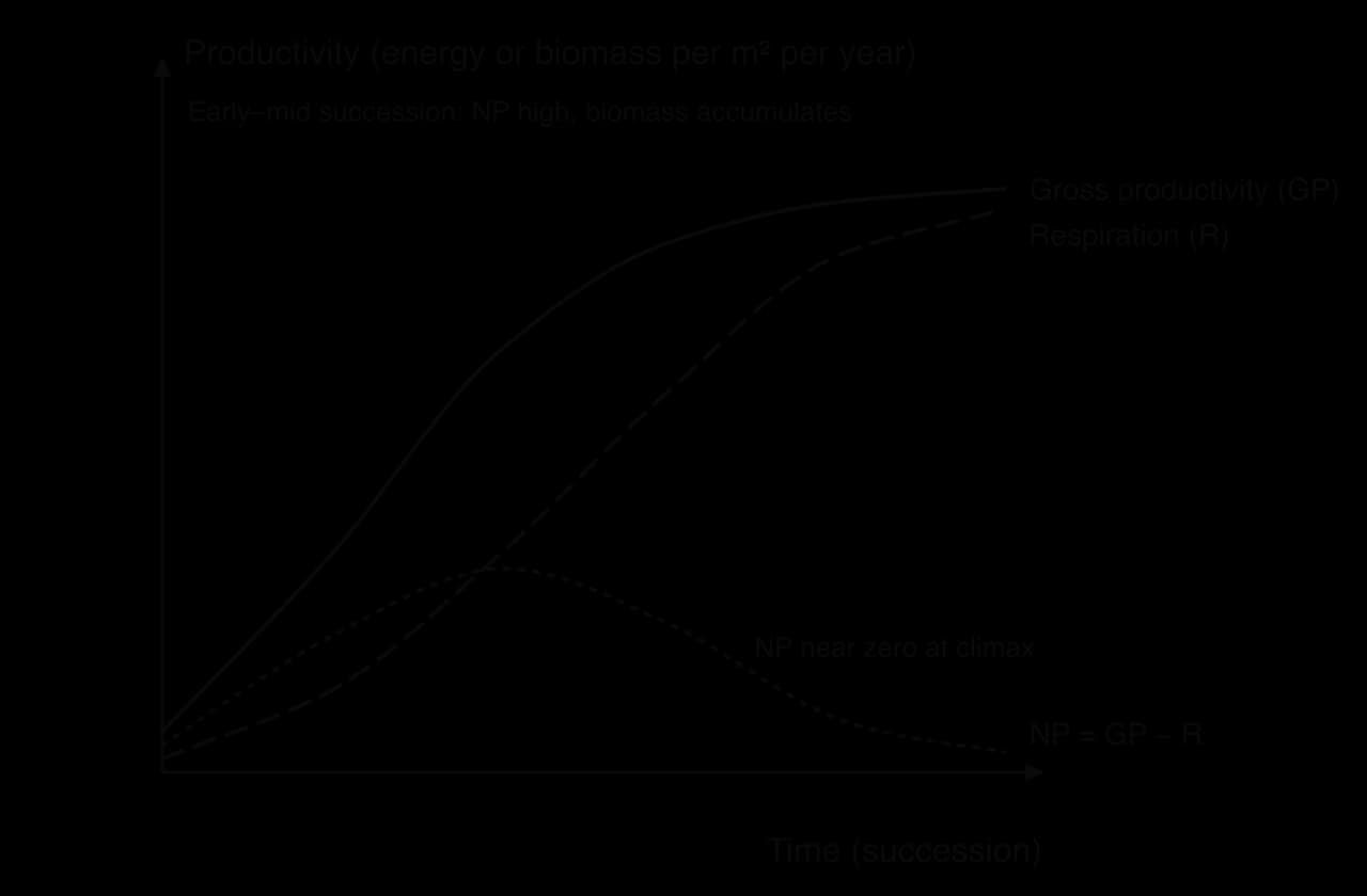
As in any ecosystem, gross productivity (GP) is the total gain in biomass or energy by producers, respiratory losses (R) are the energy used in respiration, and net productivity (NP) is what remains to be stored as new biomass:
In the early stages of succession, GP is low because conditions are harsh and producers are few and small. The community's total respiration is also low, because there is little biomass to maintain, so a relatively large proportion of GP remains as NP. The system is growing: biomass is accumulating, soil organic matter is building up and the ecosystem acts as a carbon sink.
In later stages, GP rises to a high level as a full canopy captures most of the available light. But the community now has a large biomass of producers and a large community of consumers and decomposers, all respiring. R rises until it nearly equals GP, so NP approaches zero in the climax community. Biomass is then roughly constant: what is produced each year is used in respiration or decomposed.
The Broadbalk Wilderness, still gaining carbon after more than a century, shows that a temperate woodland on former farmland had not yet reached the point where NP falls to zero. Its continuing net carbon gain is the reason why natural regeneration of woodland is valued as a way of removing carbon dioxide from the atmosphere.
Species differ in how they divide their resources between producing many offspring and helping each offspring to survive. r-strategists produce many small offspring with little parental investment, grow and mature quickly, and have short lives. K-strategists produce few, larger offspring with more investment in each, grow slowly and live long. These strategies suit different stages of succession.
Feature | r-strategists (suited to pioneer communities) | K-strategists (suited to climax communities) |
|---|---|---|
Offspring | Many, small, widely dispersed (for example light, wind-blown or sea-borne seeds) | Few, large, well provisioned (for example acorns) |
Growth and lifespan | Rapid growth, early reproduction, short life | Slow growth, late reproduction, long life |
Competitive ability | Poor competitors; succeed by arriving first | Strong competitors, often shade-tolerant |
Resources used | Short-lived, unpredictable resources on newly exposed ground | Stable resources in a crowded, long-lasting community |
Examples | Annual weeds and grasses, sea rocket on Surtsey | Oak and beech in temperate woodland |
r-strategists can colonise new habitats quickly and exploit them before competitors arrive, which is why they dominate pioneer and early seral stages. As the community becomes crowded and shaded, the advantage passes to K-strategists, whose large seeds and slow, steady growth let them establish under competition and survive for decades or centuries in the climax community.
Early in the twentieth century, Frederic Clements proposed that succession in any region leads to a single climax community determined by climate: the monoclimax theory (1916). Later ecologists challenged this. Arthur Tansley's polyclimax theory (1935) recognised several possible climaxes in one climate, controlled by soil, topography, fire and animals. Robert Whittaker's climax pattern theory (1953) saw communities as varying continuously with the environment rather than falling into distinct types.
A deeper problem is that nobody knows for certain what ecosystems would develop without human influence. People have hunted, farmed, burned and grazed most of the world's land for thousands of years, and many large herbivores were lost long ago, so there are few truly natural reference sites.
The traditional view, the "high-forest" theory, holds that after the last glaciation lowland Europe was covered by closed-canopy forest. Vera argued that oak and hazel, which are abundant in pollen records from that time, cannot regenerate well under a closed canopy because they need light. He proposed that grazing animals such as aurochs, European bison, wild horses and red deer kept the land partly open, with trees regenerating inside protective patches of thorny shrubs such as blackthorn and hawthorn.
Evidence for the Vera hypothesis | Evidence against it |
|---|---|
Oak and hazel are common in early post-glacial pollen records, but regenerate poorly under closed canopy today | Pollen records from Ireland, which had very few large herbivores, show similar amounts of oak and hazel pollen; openness may have come from windthrow and fire instead |
Pollen analysis over-represents wind-pollinated trees and may overestimate forest cover; corrected models suggest more open land | Most pollen studies still indicate predominantly forested landscapes in the early to mid Holocene |
Fossil beetles associated with grassland and dung show that open habitats existed | The same beetle evidence suggests open habitats were present but restricted |
The Vera hypothesis matters because it changes conservation priorities: if wood-pasture was the natural state, then grazing by large herbivores is part of nature rather than a human intrusion. It has been tested in practice.
At the Knepp Estate in West Sussex, England, 1,400 ha of former arable and dairy farmland has been managed since the early 2000s with free-roaming English longhorn cattle, Exmoor ponies, Tamworth pigs and red and fallow deer as stand-ins for extinct wild herbivores. The land has developed into a mosaic of grassland, scrub and trees, with large increases in rare species such as nightingales, turtle doves and purple emperor butterflies. Critics argue that a fenced estate with managed herds cannot show what the prehistoric countryside was like.
In the Oostvaardersplassen, a nature reserve on a polder in the Netherlands created in 1968, Vera's ideas were applied with Konik horses, red deer and Heck cattle left without supplementary food in winter. With no large predators and the area fenced, numbers rose until, in the winter of 2017–2018, almost 3,300 deer, horses and cattle starved. The deaths caused public protests, and the province adopted a policy of reducing herbivore numbers in 2018. The case shows that a model of "natural" grazing can conflict with animal welfare and public values, and that herbivore numbers without predators may not reproduce a natural system.
Succession does not always lead to the same end point, even under the same climate. Random events, such as which species happen to arrive first, a fire or storm at a particular time, or a run of wet or dry years, can push a community along different paths. The first species to arrive can make it harder or easier for later arrivals, so the order of arrival can matter (a priority effect). The result can be alternative stable states: different communities that are each stable under the same conditions, held in place by their own feedbacks.
Heathland and woodland on the same soils can both be stable: heather and frequent fires keep tree seedlings out, while a closed canopy shades out heather. Once a system shifts from one state to another, reversing the change may need much more than removing the original cause.
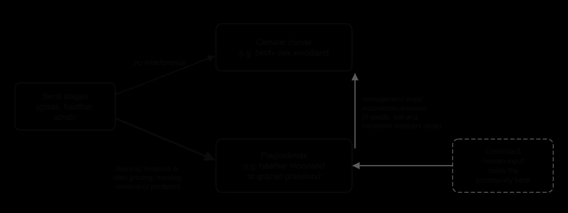
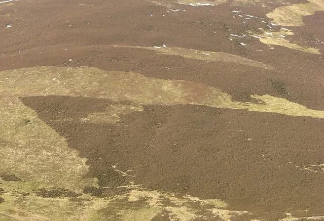
Heather moorland in the uplands of Britain is a widely studied plagioclimax. Pollen analysis shows that much of the Pennine moorland was forested in Mesolithic times. Today it is kept open by sheep grazing and by burning heather in rotation, usually when it is about 10–12 years old, to produce young shoots for grouse and sheep. If burning and grazing stopped, birch, pine and other trees would colonise much of it. Burning is now controversial: badly controlled fires can damage the underlying peat, which stores carbon, and can allow bracken and coarse grasses to spread.
Grazing by domesticated livestock keeps chalk grassland and many hill pastures from becoming scrub and woodland.
Grazing by sheep and red deer in parts of the Scottish Highlands, where wolves are extinct, has damaged the remaining Caledonian pinewoods, and restoration projects fence deer out so that tree seedlings can survive.
Mowing for hay maintains species-rich meadows.
Removal of top carnivores allows herbivore numbers to rise and suppress woody plants, as in Yellowstone before 1995.
A plagioclimax is not necessarily degraded. Heather moorland is valued as part of the cultural heritage of the uplands and as habitat for upland species, and chalk grassland can be very species-rich. Whether to maintain a plagioclimax or allow succession to proceed is a choice between values: biodiversity of open habitats, livelihoods from grouse shooting and sheep farming, cultural landscapes, carbon storage in peat and trees, and the ecocentric goal of letting natural processes return.
Sources: Wikipedia, "History of wolves in Yellowstone", "African bush elephant", "Serpentine soil", "Ecological succession", "Wood-pasture hypothesis", "Knepp Wildland", "Oostvaardersplassen", "Caledonian Forest", "Priority effect" and "Moorland", with their references; Vera, F. W. M. (2000) Grazing Ecology and Forest History.
Zonation and succession appear in Paper 2 Section A as definitions, distinctions (zonation versus succession, primary versus secondary) and data questions on transects and kite diagrams; in Paper 1 as unfamiliar field or survey data from a named place; and in Paper 2 Section B essays on change in ecosystems, resilience and management. HL questions add productivity patterns, top-down influences, the climax debate and plagioclimax.
Questions on resilience usually ask for a mechanism, so each marking point links a property of the community to the way it resists or recovers from disturbance.
The following resource is hypothetical data, written for practice. A student ran a belt transect up a rocky shore, recording the percentage cover of two species in quadrats at different heights above the low-water mark, and the mean time each height was exposed to the air per tide.
Height above low water (m) | 0.5 | 1.5 | 2.5 | 3.5 | 4.5 |
|---|---|---|---|---|---|
Exposure time per tide (hours) | 1.0 | 3.5 | 6.0 | 8.5 | 11.0 |
Species A cover (%) | 0 | 5 | 40 | 70 | 15 |
Species B cover (%) | 80 | 60 | 20 | 0 | 0 |
Zonation is the change in community along an environmental gradient (altitude, latitude, tidal level, soil depth, distance from water); abiotic factors set tolerance limits and competition and predation often decide the exact boundaries.
Zonation is investigated with line or belt transects at right angles to the zones, recording species abundance and abiotic factors at regular intervals; kite diagrams display the results.
Succession is the replacement of one community by another over time, as each seral stage changes conditions so that the next can colonise and outcompete it; zonation is spatial, succession temporal.
Succession runs from a pioneer community through seral stages to a relatively stable climax community in steady-state equilibrium; pollen records in peat provide evidence of past successions.
Primary succession starts on new substratum with no soil (Surtsey, Glacier Bay); secondary succession starts on existing soil (Broadbalk Wilderness) and is faster.
During succession, soil depth, organic matter, biomass, nutrient storage and food-web complexity increase; diversity often peaks in late seral stages.
Higher diversity and larger storages generally increase resilience and stability; human interference often reduces them.
Climate, bedrock and soil, landforms, fire and top-down influences (wolves in Yellowstone, elephants in savannas) shape the community that develops. (HL)
GP rises during succession but respiration catches up, so NP is high in early and mid stages and approaches zero at climax; r-strategists dominate pioneer stages and K-strategists the climax. (HL)
The single climax is contested: the Vera hypothesis proposes a grazed wood-pasture as Europe's natural state, and random events can produce alternative stable states. (HL)
Human activity such as burning, grazing and mowing can hold a community at a plagioclimax, such as heather moorland, which persists only while the activity continues. (HL)
I can define zonation and explain how abiotic and biotic factors produce it along an environmental gradient.
I can describe how to investigate zonation with a transect and construct and interpret a kite diagram.
I can distinguish between zonation and succession.
I can explain how each seral stage changes conditions until a climax community is reached.
I can distinguish between primary and secondary succession using named examples.
I can explain how energy flow, productivity, diversity, soil depth and nutrient cycling change during succession.
I can discuss the links between diversity, resilience, stability, succession and human activity.
I can explain how climate, rock, soil, landforms, fire and top-down influences shape the final community. (HL)
I can explain the pattern of GP, R and NP during succession and the roles of r- and K-strategists. (HL)
I can evaluate the climax concept, including the Vera hypothesis and alternative stable states. (HL)
I can explain how human activity produces a plagioclimax, with an example. (HL)