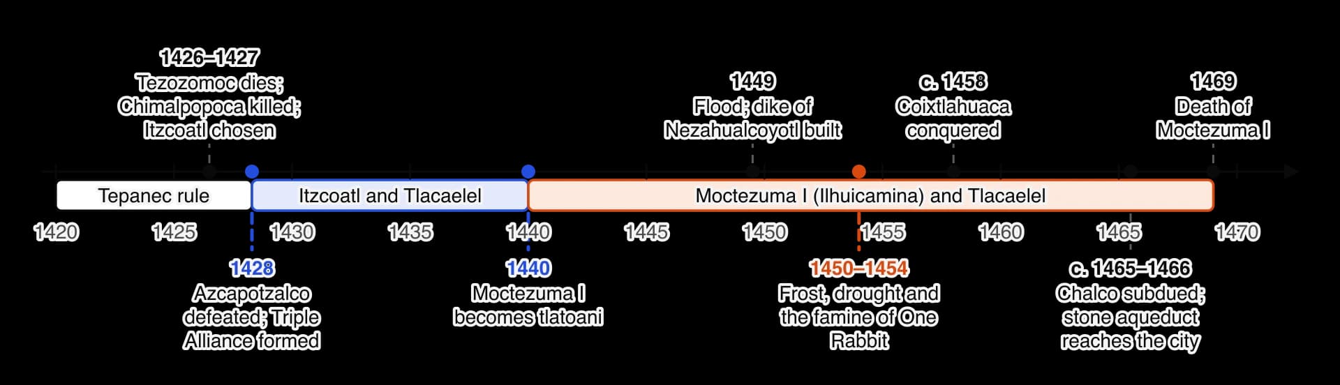
Explain how the Triple Alliance, its rulers and the climate of the Basin of Mexico prompted Aztec innovations in water, farming, the city and empire, 1428–1469.
Each is in the History glossary, with every other term in the subject.
The dike about 16 km long built across Lake Texcoco after the flood of 1449, which protected Tenochtitlan from floods and separated salty eastern water from the fresher lagoon around the city.
The basic political unit of central Mexico: a city-state made up of a town, its villages and lands, with its own ruler, temple and patron god.
The incorporation of a territory into a state or empire. In the Aztec Empire it usually meant assigning a conquered region to a tribute province while its own rulers stayed in place.
A temple school, mainly for the sons of nobles, that trained priests, judges and officials in religion, history, the calendar and the reading of painted books.
A Mexica steward placed in a conquered town to collect tribute and send it to the capitals of the Triple Alliance.
A ward or neighbourhood of an Aztec town that held land in common and had its own temple, school and military unit.
A raised road built across water or marsh. Tenochtitlan was joined to the shore by causeways with removable bridges, which also acted as dikes.
A raised field built from layers of mud and vegetation in a shallow freshwater lake and surrounded by canals, which allowed intensive farming with several harvests a year.
The Aztec Empire was the alliance of three city-states in the Basin of Mexico that, from 1428 until the Spanish conquest of 1521, dominated much of central and southern Mexico through war and tribute. Its first four decades show how a society in a demanding highland environment met floods, frost and famine with new engineering, new ways of farming and an expanding empire.
With a free account, Augment remembers where you stopped and what you have practiced.
The second office in the Mexica state after the tlatoani, responsible for justice, finance and the city's internal affairs. Tlacaelel held it under Itzcoatl and Moctezuma I.
A hand-made book. In Mesoamerican history it means the painted books of the Aztecs, Mixtecs and Maya and the illustrated manuscripts made by Indigenous painters after the Spanish conquest.
A pictorial manuscript made in Mexico City about twenty years after the Spanish conquest for the viceroy Antonio de Mendoza, recording the Mexica rulers and their conquests, the tribute of each province and daily life, with Spanish notes.
The name given by the historian Robert Barlow in 1945 to a lost Nahuatl history of Tenochtitlan that both Diego Durán and Hernando Alvarado Tezozomoc used as their main source.
The dating and study of tree rings. Because a tree adds one ring a year, wider in good years and narrower in poor ones, ring patterns date wood exactly and give a record of past climate.
Elite Aztec military orders whose members had taken several captives in battle and wore distinctive costumes and enjoyed noble privileges.
A drainage basin with no outlet to the sea, where water leaves only by evaporation or seepage, so that salts collect in its lowest lake.
The famine in the Basin of Mexico that followed frosts and drought from about 1450 and was worst in the year One Rabbit (1454). It is one of the most widely recorded disasters in the annals before the Spanish conquest.
The twelve-book encyclopedia of Nahua life and history in Nahuatl and Spanish, compiled by the friar Bernardino de Sahagún with Nahua scholars and completed in 1577.
A pre-arranged, limited war between the Triple Alliance and cities such as Tlaxcala and Huexotzinco, fought to take captives and display courage rather than to conquer. Its purpose is debated by historians.
An empire that controls its subjects indirectly, leaving local rulers in place and relying on tribute and the threat of force rather than occupation and direct government.
"Great speaker": the title of the ruler of Tenochtitlan as leader of the Triple Alliance.
The patron god of the Mexica, a god of war and the sun, worshipped in one of the two shrines on the Templo Mayor.
The ritual killing of people as an offering to gods. In Mexica belief it repaid the gods for creating the world and kept the sun moving; it was practised across Mesoamerica.
An Aztec commoner. Commoners held land through their calpulli, paid tribute in goods and labour and served as soldiers.
Landless labourers who worked the private estates of Aztec nobles in return for a plot of land, a group that grew as nobles received conquered lands.
The cultural region of central and southern Mexico and northern Central America whose peoples, including the Olmecs, Maya and Aztecs, shared farming, calendars, writing and religious practices before the Spanish conquest.
An agricultural terrace on a hillside in central Mexico, often edged with maguey plants, that held soil and water and reduced erosion.
The Nahuatl-speaking people of Tenochtitlan and its twin city Tlatelolco, the leading partner in the Aztec Empire. "Aztec" is a later label; the Mexica used this name for themselves.
A Mesoamerican field in which maize, beans and squash are grown together, the beans enriching the soil and the squash suppressing weeds.
The language of the Mexica and many other peoples of central Mexico, still spoken by more than 1.5 million people in Mexico (2020 census). Nahua is the name for the peoples who speak it.
The first year of the 52-year Mexica calendar cycle; 1454 was a One Rabbit year. After the famine of that year, One Rabbit years were feared as times of disaster.
A member of the Aztec hereditary nobility. Nobles held offices, priesthoods and, after 1428, estates on conquered land, and paid no tribute.
The professional long-distance merchants of the Aztec world, organised in guilds, who traded beyond the empire and sometimes served as spies.
A law that limits what people of different ranks may wear, eat, own or build, so that each person's status is visible.
"House of youth": the school of each calpulli where commoner boys were trained for war and public labour.
The great twin temple of Huitzilopochtli and Tlaloc at the centre of Tenochtitlan, rebuilt and enlarged in at least seven main stages and excavated since 1978.
"Hot land": the warm, frost-free lowlands of Mexico, such as the Gulf coast and Morelos, which produced cotton, cacao and tropical crops that the cool highlands could not.
An Aztec slave, usually a person sold or self-sold for debt or as a punishment. Slaves could own property and their children were born free.
The Mesoamerican god of rain and agriculture, worshipped in one of the two shrines on the Templo Mayor of Tenochtitlan.
The ruler of an altepetl, literally "speaker". A tlatoani was chosen from the royal family by a council of nobles.
A regular payment of goods, labour or services by a subject people to a ruler or state in recognition of its authority.
The alliance of Tenochtitlan, Texcoco and Tlacopan formed in 1428 after the defeat of Azcapotzalco, which ruled the Aztec Empire and shared its tribute.
A rack on which the skulls of sacrificed people were displayed. The great tzompantli of Tenochtitlan has been partly excavated since 2015.
"Binding of the years": the 52-year cycle of the Mesoamerican calendar, after which each year name recurred.
The word "Aztec" was not used by the people it describes. It was popularised by European and Mexican scholars in the eighteenth and nineteenth centuries, from Aztlan, the homeland from which the Mexica believed they had migrated. The people of Tenochtitlan called themselves the Mexica (pronounced "meh-SHEE-ka"), and spoke Nahuatl, the main language of central Mexico. Historians now usually say "Mexica" for the people of Tenochtitlan and "Aztec Empire" or "Triple Alliance" for the empire they shared with Texcoco and Tlacopan.
The basic political unit of central Mexico was the altepetl, a city-state of a town and its surrounding villages and lands, with its own ruler, temple and patron god. Each altepetl was ruled by a tlatoani ("speaker"), a hereditary ruler chosen from the royal family by a council of nobles. Within the alliance, the ruler of Tenochtitlan came to be called the huey tlatoani, "great speaker". Below the altepetl, people lived in calpulli, wards or neighbourhoods that held land in common, worshipped at their own temple, sent men to war as a unit and ran a school for their boys.
Term | Meaning | Why it matters |
|---|---|---|
Aztec | A later label, from the legendary homeland Aztlan | Useful for the empire as a whole, but not what the people called themselves |
Mexica | The people of Tenochtitlan and Tlatelolco | The partner that wrote most surviving histories and came to dominate the alliance |
Nahua, Nahuatl | The peoples of central Mexico who spoke Nahuatl, and their language | Texcocans, Tepanecs, Chalcans and Tlaxcalans were Nahuas too; "Nahua" is not the same as "Mexica" |
altepetl | A city-state with its ruler, lands and patron god | The unit that conquered and was conquered; the empire was a network of altepetl |
tlatoani (plural tlatoque) | The ruler of an altepetl | Conquered rulers kept this title, which is why the empire was indirect |
According to their own traditions, recorded in pictorial histories such as the sixteenth-century Codex Boturini, the Mexica left Aztlan in the twelfth century and wandered for generations, guided by their patron god Huitzilopochtli, a god of war and the sun. They reached the Basin of Mexico as late arrivals in a valley already full of established city-states. Their founding legend says that they settled where they saw an eagle perched on a prickly pear cactus on an island in Lake Texcoco. The traditional date for the founding of Tenochtitlan is 1325; Tlatelolco, a twin city on the northern part of the same island, was founded by a breakaway group a few years later.
The island was poor land, marshy and surrounded by salty water, which is probably why nobody else wanted it. It did offer fish, waterfowl and reeds, protection from attack, and canoe routes to every town on the lakes. The Mexica began building up the marsh into house plots and fields, the first step towards the chinampa system and the planned city of the fifteenth century.
For the century before 1428 the most powerful state in the basin was Azcapotzalco, the capital of the Tepanecs on the western shore of the lake. Under its long-lived ruler Tezozomoc, who died in 1426, Azcapotzalco built an empire of tributary cities around the lakes. The Mexica were among its subjects. They paid tribute, fought as mercenaries in Tepanec wars and needed Tepanec permission to use resources on the mainland, such as the springs at Chapultepec that supplied their drinking water.
This dependence was also an apprenticeship. Mexica rulers married into the Tepanec royal family; the tlatoani Chimalpopoca (r. about 1417–1427) was a grandson of Tezozomoc. Mexica warriors learned how a tribute empire worked by helping to build one. When the Mexica built their own empire after 1428, they used many Tepanec methods, from tribute assessment to the practice of leaving defeated rulers in place.
The Mexica and their neighbours kept records in painted books on deer skin or bark paper, using pictures, place-name signs, year signs and numbers. These books recorded histories, tribute, genealogies, land and religious calendars, and trained specialists "read" them aloud with memorised commentary. Almost none of the historical books survived. Some were destroyed in the wars of 1428–1430 and in Itzcoatl's burning of older histories; far more were burned by Spanish missionaries after 1521 or lost over time. Of the roughly 160 known manuscripts painted by Indigenous artists in Mexico, only about one in ten is thought to be pre-Hispanic, and none of the historical annals is.
Most of what is known about 1428–1469 therefore comes from sources made between about 1530 and 1650. They fall into five main kinds, each with its own perspective.
Kind of source | Main examples | Strengths | Problems |
|---|---|---|---|
Post-conquest pictorial codices | Codex Mendoza (Mexico City, c. 1541–1542); Codex Telleriano-Remensis (1550s–1560s) | Copied from older Mexica painted records; year-by-year annals and tribute lists | Selected and explained for Spanish readers; the glosses can misread the pictures |
Annals written in Nahuatl | Annals of Cuauhtitlan (in the Codex Chimalpopoca, c. 1570); the annals of Chimalpahin of Chalco (c. 1600–1630) | Written by Nahuas in their own language; each records the history of one altepetl, so they can be checked against each other | Written a century or more after events; each favours its own city |
Friars' histories | Bernardino de Sahagún with Nahua scholars, Florentine Codex (completed 1577); Diego Durán, History of the Indies of New Spain (1581) | Based on interviews with elders and on lost Nahuatl chronicles; detailed narratives | Written by missionaries who wanted to understand native religion in order to replace it; Durán's source glorified Tenochtitlan |
Conquistadors' accounts | Hernán Cortés, Second Letter (1520); Bernal Díaz del Castillo, True History (written c. 1568) | Eyewitness descriptions of the city, its causeways, markets and aqueduct | Describe 1519–1521, half a century later; written to impress the king or to defend the authors' role |
Science and archaeology | Excavations at the Templo Mayor (since 1978); chinampa fields; tree-ring records | Independent of any writer's purpose; can date and test written claims | Show what was built or what the climate did, not why people acted |
Durán's history and the Crónica Mexicana of Hernando Alvarado Tezozomoc, a grandson of Moctezuma II, follow the same lost Nahuatl history of Tenochtitlan, which the historian Robert Barlow named the Crónica X in 1945. That chronicle gave Tlacaelel a leading part in almost every event. Because both writers depend on it, their agreement is not independent corroboration, and Tlacaelel's importance may be partly the work of his descendants' memory. Texcocan writers such as Fernando de Alva Ixtlilxochitl (c. 1578–1650), a descendant of the rulers of Texcoco, gave Nezahualcoyotl the leading role instead.
Dendrochronology, the dating and study of tree rings, gives evidence that no writer shaped. In most climates a tree adds one ring of wood each year, and the ring is wider in a wet year and narrower in a dry one. By matching the patterns of wide and narrow rings in living trees, old timbers and dead wood, scientists build a chronology that dates every ring to its exact year. The average ring width is set at 1.0, so a value of 0.7 means a year of poor growth, which in central Mexico usually means drought and a poor maize harvest.
In 2004 the geoscientists Matthew Therrell and David Stahle and the epidemiologist Rodolfo Acuña-Soto compared the drought years recorded in Aztec annals with tree-ring chronologies from northern and central Mexico. Their study is the main scientific test of the written record of the famine of One Rabbit. It is a proxy record: it measures tree growth, which stands in for rainfall that nobody measured directly.
The innovations of 1428–1469 had political as well as environmental roots. A new state with new leaders, new wealth and a new view of its own destiny was able to organise labour and resources on a scale the basin had not seen since the fall of Tula. Three developments created that state: the Triple Alliance, the reforms that turned victory into an empire, and the long reign of Moctezuma I.
The death of Tezozomoc in 1426 set off a struggle for the throne of Azcapotzalco. His son Maxtla seized power from the heir his father had chosen and set out to tighten Tepanec control over the cities that had backed his rival. In 1427 Chimalpopoca, the Mexica tlatoani, died, probably murdered. Most sources blame Maxtla; some modern historians suspect that rivals inside Tenochtitlan who wanted a harder line against Azcapotzalco may have been involved.
The Mexica nobles chose Itzcoatl ("Obsidian Serpent"), a son of the first tlatoani Acamapichtli by a woman of low rank, as their ruler. Itzcoatl was experienced and backed by a group of younger nobles, including his nephews Tlacaelel and Moctezuma Ilhuicamina, who argued for war rather than submission. Some later accounts describe a debate in which commoners feared the war and the nobles promised to serve them if it failed, in return for their obedience if it succeeded; this story, preserved by Durán, justified the privileges the nobles gained afterwards.
Itzcoatl's main achievement was diplomatic. He allied with Nezahualcoyotl, the exiled heir of Texcoco, whose father Ixtlilxochitl had been killed in a Tepanec war in 1418. He won over the Tepanec city of Tlacopan, whose ruler Totoquihuaztli had his own grievances against Maxtla, and gained troops from Huexotzinco beyond the mountains. In 1428 the allies besieged and took Azcapotzalco. Fighting against other Tepanec towns, including Coyoacan, went on for two or three more years.
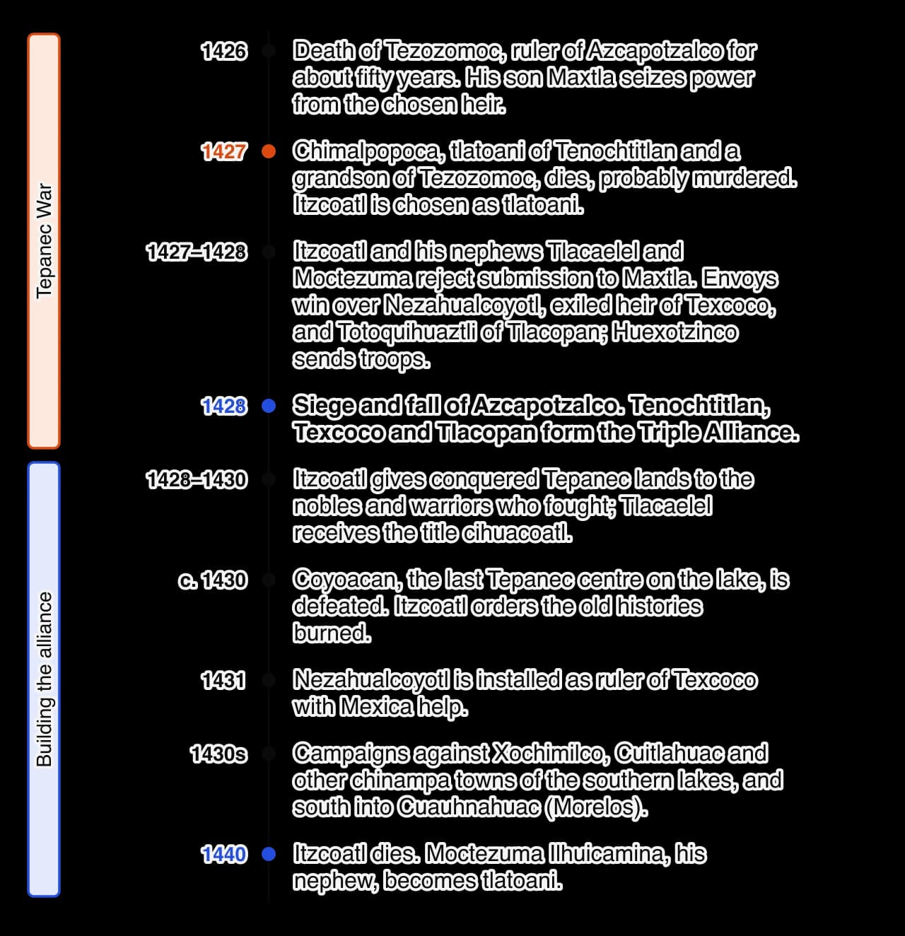
After the victory Tenochtitlan, Texcoco and Tlacopan agreed to campaign together and share what they won. Most sources say tribute was divided in the proportion of two-fifths each to Tenochtitlan and Texcoco and one-fifth to Tlacopan. Texcoco led the cities on the eastern side of the lakes (the Acolhua), Tlacopan the western Tepanec towns, and Tenochtitlan took the lead in war. The alliance was cemented by marriages among the three royal families and by joint building projects.
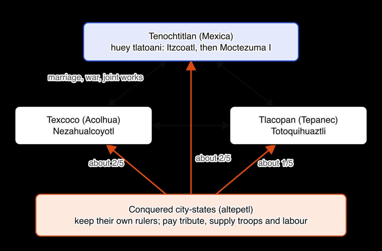
The alliance began as a partnership of near-equals but did not stay one. Tenochtitlan supplied the war leaders, received the most lands in conquered territories and, by the reign of Moctezuma I, was clearly the senior partner. Its ruler was the huey tlatoani of the whole alliance. Texcoco under Nezahualcoyotl remained powerful, especially as a centre of law, poetry and engineering, while Tlacopan was always the junior member.
Itzcoatl used the victory to change Mexica society. The lands of conquered Tepanec towns were divided among the ruler, the leading nobles and warriors who had distinguished themselves, so that a landed nobility with estates worked by dependent labourers grew up for the first time. Tlacaelel received the title cihuacoatl, the second office in the state after the tlatoani, responsible for justice, the treasury and the city's internal affairs. New councils and military titles rewarded success in war.
The reforms also rewrote the past. According to the Florentine Codex, the ruler and his council ordered the older painted histories to be burned.
The history of it was saved, but it was burned when Itzcoatl ruled in Mexico. A council of rulers of Mexico took place. They said: "It is not necessary for all the common people to know of the writings; government will be defamed, and this will only spread sorcery in the land." . . .
Bernardino de Sahagún and Nahua scholars, Florentine Codex, Book 10, completed 1577 (trans. Charles Dibble and Arthur Anderson, 1961). The passage was recorded from Nahua elders about 150 years after the event. It shows that the Mexica themselves remembered Itzcoatl's reign as a moment when the official version of history was fixed; the reason given, that the old books would "defame" government, suggests that they recorded the Mexica's humble past as Tepanec subjects. Every history written later, including those used by Durán, descends from the version approved after this burning.
The new history placed the Mexica and their god Huitzilopochtli at the centre of the world. It presented them as a chosen people whose wars fed the sun with the blood of sacrificed captives and so kept the universe in motion. Historians such as Miguel León-Portilla linked this ideology to Tlacaelel. Whether or not one man created it, the ideology gave warriors honour, justified expansion and bound the nobility to the state.
The Triple Alliance did not occupy the lands it conquered or replace their rulers. A defeated altepetl kept its own tlatoani, nobles, temples and laws, so long as it paid tribute on schedule, supplied soldiers and labour when called and did not rebel. Tribute was collected by officials called calpixque (singular calpixqui), Mexica stewards posted in the main towns of each tribute district. Garrisons were placed only in some frontier and rebellious areas. Ross Hassig called this a hegemonic empire: it ruled through the threat of force and the self-interest of local rulers, not through direct administration.
The system had clear advantages for a state without draught animals or wheeled transport. It needed few officials and no standing army of occupation, and it brought goods to the capitals that the basin could not produce, such as cotton, cacao, tropical feathers and greenstone. Its weakness was that subject cities stayed loyal only while the alliance looked strong. Rebellions after the death of a ruler were common, and reconquests appear again and again in the conquest lists.
Mexica society after 1428 was a steep hierarchy, but one that offered some movement through success in war. The reforms of Itzcoatl and Moctezuma I made the divisions sharper and linked rank more tightly to service to the state.
Group | Nahuatl term | Position |
|---|---|---|
Ruler | tlatoani; huey tlatoani | Chosen from the royal family by a council of nobles; head of war, religion and justice |
Nobles | pipiltin (singular pilli) | Born to noble families; held offices, priesthoods and estates after 1428; educated in the calmecac; paid no tribute |
Commoners | macehualtin (singular macehualli) | Most of the population; held land through their calpulli; paid tribute in goods and labour; served as soldiers |
Landless labourers | mayeque | Worked the private estates of nobles in return for a plot; a growing group as nobles gained conquered land |
Slaves | tlacotin (singular tlacotli) | Mostly people who sold themselves or were sold for debt or as punishment; could own property and their children were born free |
Long-distance merchants | pochteca | Organised in guilds; traded beyond the empire, sometimes as spies; rich but expected to hide their wealth before nobles |
A commoner could rise by taking captives in battle. Warriors were promoted by the number of captives they had taken, and each grade brought the right to wear a particular cloak or war costume, gifts from the ruler and a voice in the councils of warriors; the most distinguished joined the elite Eagle and Jaguar orders. The Codex Mendoza shows these grades step by step. Captives, more than enemies killed, measured success, because captives could be offered to the gods. This system tied the ambitions of ordinary men to the expansion of the empire.
All boys received some formal education, which was unusual in the fifteenth-century world. Sons of commoners attended the telpochcalli ("house of youth") of their calpulli, where they were trained for war and for public labour. Sons of nobles, and some talented commoners, attended the calmecac, a temple school that trained priests, judges and officials in religion, history, the calendar and the reading of painted books.
The Flower Wars (in Nahuatl xochiyaoyotl) were wars arranged between the Triple Alliance and the cities of the Puebla–Tlaxcala valley east of the volcanoes: Tlaxcala, Huexotzinco and Cholula. Armies met on a date and at a place agreed beforehand, fought in limited numbers and returned home. The aim was not to conquer the enemy's city but to take captives and display courage. Captives taken in these battles were sacrificed in the capitals of both sides.
Durán dates the origin of this kind of war to the famine of the early 1450s and gives the credit to Tlacaelel. In his account, the priests explained the disasters as the anger of the gods, and Tlacaelel proposed a regular "market" of war near home where warriors could obtain captives for sacrifice whenever they were needed, instead of on distant campaigns. The Texcocan historian Alva Ixtlilxochitl also links the wars to the famine, but presents them as an agreement among the rulers of the alliance and of Tlaxcala and Huexotzinco, with no special part for Tlacaelel. Chimalpahin records a flower war between the Mexica and Chalco decades earlier, which suggests that the famine changed an existing kind of warfare rather than inventing it.
Historians disagree about what the Flower Wars were for. The disagreement matters because it is a disagreement about what drove the empire: religion, military need or politics.
Interpretation | Historian | Argument | Evidence stressed |
|---|---|---|---|
Religious | Durán (1581); many twentieth-century writers | Fought to supply captives for sacrifice and so keep the gods and the sun nourished | Durán's account of Tlacaelel's proposal during the famine; the ideology of sacrifice |
Training and sport | Frederic Hicks, "Flowery war" in Aztec history (1979) | Most wars called "flowery" in the sources were not aimed at conquest; their usual motive was military training and practice | The annals of Chimalpahin, which describe flower wars turning into serious wars |
Geopolitical | Barry Isaac, "The Aztec Flowery War: a geopolitical explanation" (1983) | The wars were real and bloody; the alliance tried and failed to conquer Tlaxcala, and called the stalemate "flowery" to hide that failure | Heavy casualties in the battles of 1503–1517; Huexotzinco's change of sides in the 1500s |
Strategic attrition | Ross Hassig, Aztec Warfare (1988) | A low-cost way to fight an enemy too strong to defeat at once: it showed strength, tied the enemy down and wore it out while the empire grew around it | The encirclement of Tlaxcala by conquests on all sides; the cost of a full campaign across the mountains |
Hicks concluded that most wars the sources call flowery were simply wars not aimed at conquest, fought mainly as military training and practice. Hassig, writing nine years later, did not deny religious motives but explained the wars mainly in political and economic terms. The interpretations are not mutually exclusive. Religion explains why captives were valued; military and political needs explain why the alliance chose limited war with its strongest neighbours.
Human sacrifice was practised across Mesoamerica long before the Mexica, but the Mexica carried it out on a larger scale than their predecessors, especially at the dedication of temples and in the festivals of Huitzilopochtli and the rain god Tlaloc. Spanish writers gave very large numbers of victims, which modern historians treat with caution because the conquerors used them to justify the conquest. Archaeology confirms that the practice was large: excavations since 2015 near the Templo Mayor have uncovered part of the great skull rack, or tzompantli, holding hundreds of skulls of men, women and children.
For the Mexica, sacrifice repaid a debt to the gods, who had sacrificed themselves to create the sun and the world. It also had political effects. Ceremonies to which enemy rulers were invited displayed Mexica power, and the demand for captives encouraged war. Historians such as Caroline Dodds Pennock argue that it should be understood within Mexica beliefs, and compared with the public, religious executions of contemporary Europe, rather than treated as a sign of savagery.
Moctezuma Ilhuicamina, known as Moctezuma I to distinguish him from his great-grandson Moctezuma II (r. 1502–1520), ruled Tenochtitlan for twenty-nine years. His second name means "he who shoots arrows at the sky". He was a son of the tlatoani Huitzilihuitl, a nephew of Itzcoatl and a brother (some sources say half-brother) of Tlacaelel. He had been a war leader in the Tepanec War, and he was chosen by the council of nobles when Itzcoatl died in 1440. Tlacaelel remained cihuacoatl throughout his reign.
Moctezuma I's first task was to hold what Itzcoatl had won. Subject cities often rebelled when a ruler died, and several had to be reconquered. He then pushed the alliance's power beyond the basin, especially south into the warm valleys of Morelos, where cotton grew, and east and south-east towards the Gulf coast and Oaxaca. The Codex Mendoza credits him with thirty-three conquests or reconquests, compared with about two dozen for Itzcoatl.
Date (approximate) | Campaign | What it gave the alliance |
|---|---|---|
1440s | Southern Morelos, including Huaxtepec (Oaxtepec) | Cotton, cloth and warm-land crops; the site of a royal garden |
1440s–c. 1465 | Long, intermittent war with Chalco, ending in its conquest | The fertile chinampa lands of Lake Chalco and food tribute; the Chalca rulers fled to Huexotzinco |
c. 1458 | Coixtlahuaca in the Mixteca of Oaxaca | A trading centre on the routes south; rich tribute in cloth and luxury goods |
1440s–1450s | Northern Guerrero, including Tlachco (Taxco) and Tepequacuilco | Cotton cloth, copper and other goods of the warm valleys south of the basin |
1450s | The Huastec region of the northern Gulf coast (in Durán's account) | Cotton cloth and tropical goods; prestige and captives |
late 1450s–1460s | Gulf coast: Cuetlaxtlan and the Totonac lands (Totonacapan) | Maize, cotton and tropical goods from a region that escaped highland frost and drought |
Dates for individual campaigns vary between sources by several years, because the annals of different cities used different year counts and recorded the wars that mattered to them. The direction of expansion is clear, however. Moctezuma I led the alliance from the cool basin towards the warm, wet lowlands that produced what the highlands could not, a direction that became more urgent after the famine of the 1450s.
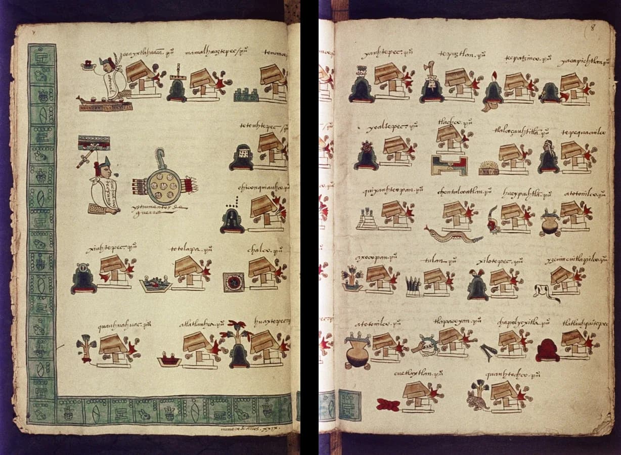
The pages of the Codex Mendoza that list Moctezuma I's conquests are a source in their own right. They show conquest as Tenochtitlan recorded it: each town is reduced to a place sign and a burning temple, and the list makes no distinction between a short raid and a long war such as the struggle with Chalco. The codex was made for the Spanish viceroy Antonio de Mendoza, so it also shows what Mexica painters and their Spanish patrons thought worth explaining to the king: who had ruled, what they had conquered and what tribute each province owed.
Durán describes a set of laws issued under Moctezuma I with Tlacaelel. They regulated who could wear what and live where: only the ruler and the highest nobles could wear certain fine cotton cloaks, jewels and sandals in the palace; commoners were to wear cloth of maguey fibre; only great lords and distinguished warriors could build houses with an upper storey. Other laws dealt with justice, drunkenness and the duties of each calpulli to maintain a temple and a school.
The laws turned the distinctions created after 1428 into public, visible rules. They rewarded nobles and warriors and made the hierarchy appear permanent and god-given. Because they come mainly from Durán and his Tenochtitlan source, which presents Moctezuma I as a model lawgiver, historians accept their general character more readily than the exact wording of each rule.
Moctezuma I enlarged the Templo Mayor, the twin pyramid-temple of Huitzilopochtli and Tlaloc at the centre of Tenochtitlan. Archaeologists identify a major rebuilding known as Stage IV with his reign; it carried large stone sculptures and many buried offerings, some of them goods brought as tribute or plunder from conquered regions. Durán's history says that the long war with Chalco began when the Chalca refused a Mexica demand for stone and labour for the temple. Whether or not that was the real cause, the story shows how building projects were tied to the demand for tribute and service.
With Nezahualcoyotl he directed the dike of 1449 and the rebuilding of the aqueduct from Chapultepec, completed about 1465–1466. Durán also describes a royal garden that Moctezuma I created at Huaxtepec in Morelos, stocked with plants brought from the Gulf coast and other conquered lands. It was a pleasure garden, a collection of medicinal plants and a statement that the ruler commanded the resources of the whole empire.
 YouTube
Moctezuma I's reign saw the alliance grow from a power in the basin into an empire reaching the Gulf coast and Oaxaca, and it saw the greatest water works and the response to the worst famine of the period. Measured by results, he was the most important ruler of these four decades. The evidence makes his personal role harder to judge. Durán's source credits Tlacaelel with most decisions, Texcocan writers credit Nezahualcoyotl with the engineering, and the work itself was done by thousands of labourers from subject towns. His significance lies in holding these forces together for twenty-nine years, longer than any other tlatoani.
The Basin of Mexico offered rich resources and serious dangers. Its lakes gave fish, birds, transport and water for farming, but its altitude brought frost, its rainfall varied from year to year, and its lakes could flood or turn salty. Every major innovation of the period answered one of these conditions.
The Basin of Mexico is a high plateau about 2,240 metres above sea level, ringed by mountains and volcanoes, including Popocatépetl and Iztaccíhuatl, which rise above 5,000 metres to the south-east. It is an endorheic basin: no river drains it to the sea. Rain and melting snow ran down from the mountains into a chain of shallow lakes on the basin floor, which in the fifteenth century covered more than a thousand square kilometres in the wet season.
Because water left only by evaporation, salts built up in the lowest part of the system, Lake Texcoco, whose water was too salty to drink or to use on fields. The southern lakes, Xochimilco and Chalco, were higher and were fed by springs at the foot of the mountains, so they stayed fresh. The northern lakes, Zumpango and Xaltocan, were brackish. In the wet season the lakes rose and joined into one sheet of water; in the dry season they shrank and separated.
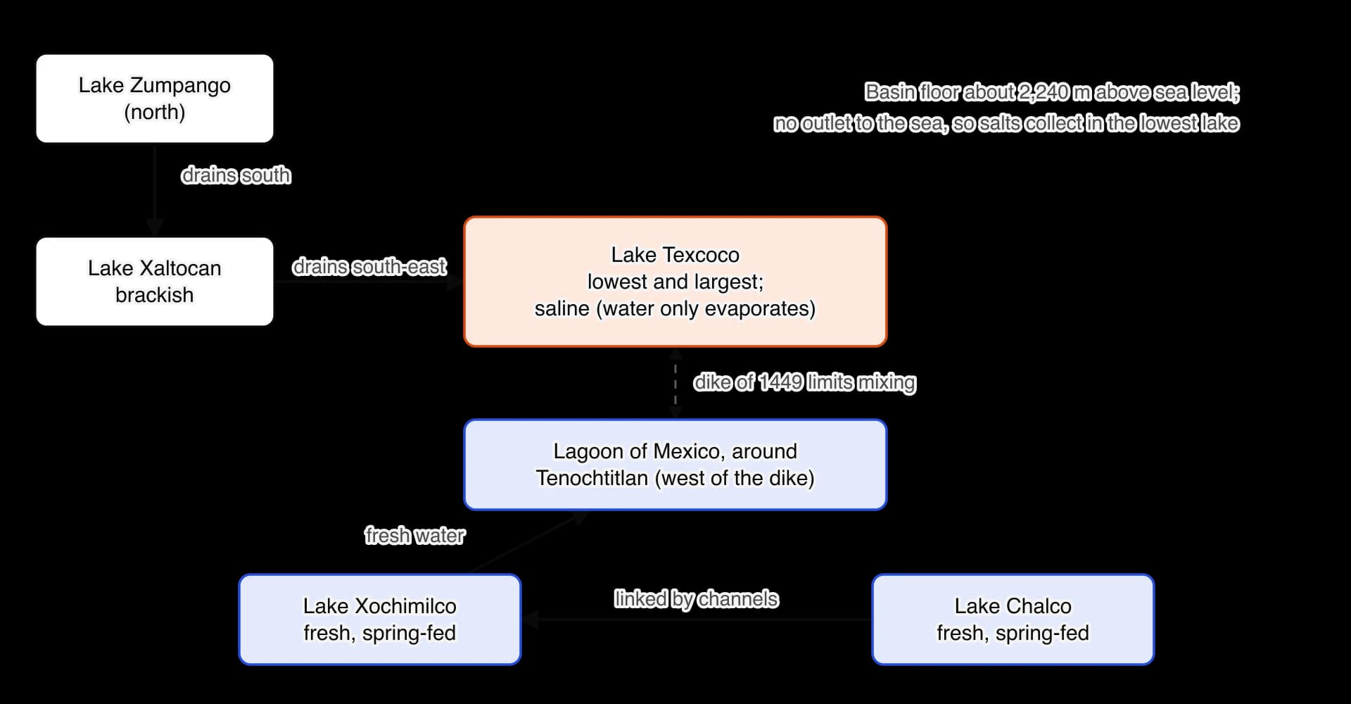
The climate had two seasons. Most rain fell between about June and September, and the winter dry season brought clear skies and cold nights. At this altitude frost could strike in autumn, before maize had ripened, or in spring after it had been planted. A late start to the rains or an early frost could ruin a harvest across the whole basin at once. Maize, the staple food, was especially vulnerable, which is why the annals record frosts, snowfalls, hail and droughts so carefully.
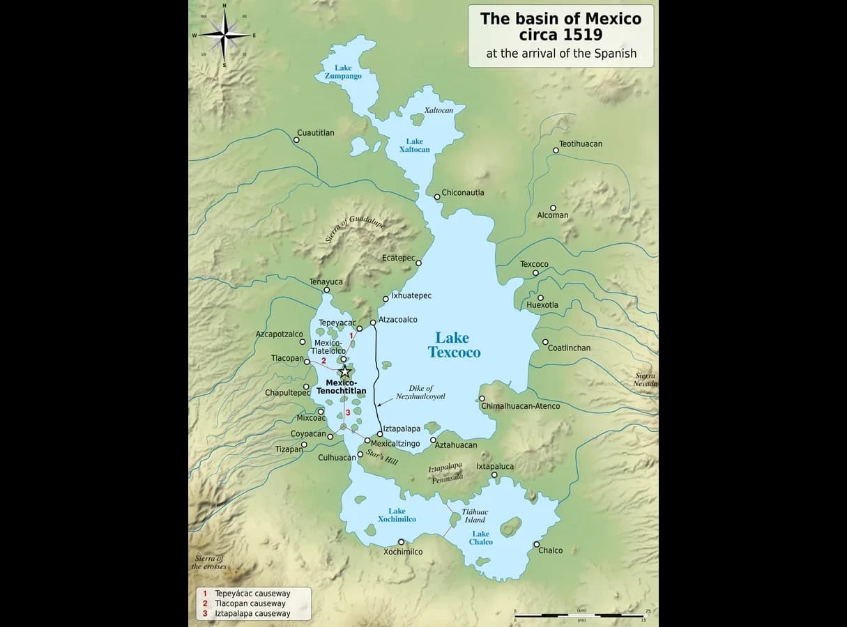
The map of the basin around 1519 shows the result of a century of engineering laid over this natural pattern: causeways crossing the lakes to the island city, the long dike east of Tenochtitlan, and towns crowded along the shores. Most towns lay at the edge of the lakes, where they could farm both the lake margins and the hill slopes behind them.
Condition | Danger | Opportunity |
|---|---|---|
High altitude (about 2,240 m) | Frost in spring and autumn; short growing season for maize | Dry winter season suited to storing grain and to building |
Closed basin with shallow lakes | Floods in wet years; salt in Lake Texcoco | Fish, birds, reeds and insects; canoe transport across the lakes |
Seasonal, variable rainfall | Drought and crop failure when the rains failed | Fresh springs in the south; moisture held in lake-bed soils |
Volcanic soils on slopes | Erosion when slopes were cleared | Fertile land when terraced |
Water was both the city's defence and its greatest problem. Tenochtitlan needed three things: protection from floods, fresh water around the city for chinampas and canals, and clean drinking water for a population that grew from perhaps tens of thousands in 1428 to well over a hundred thousand by 1519.
In 1449 heavy rains raised Lake Texcoco until it flooded Tenochtitlan, destroying houses and damaging the existing aqueduct. Moctezuma I turned to Nezahualcoyotl of Texcoco for a solution. The result was a dike, known as the albarradón of Nezahualcoyotl, built across the lake east of the city. It ran about 16 kilometres from the northern shore near Atzacoalco to Iztapalapa in the south and was built of stone and packed earth held between rows of wooden stakes, with gates that could be opened and closed.
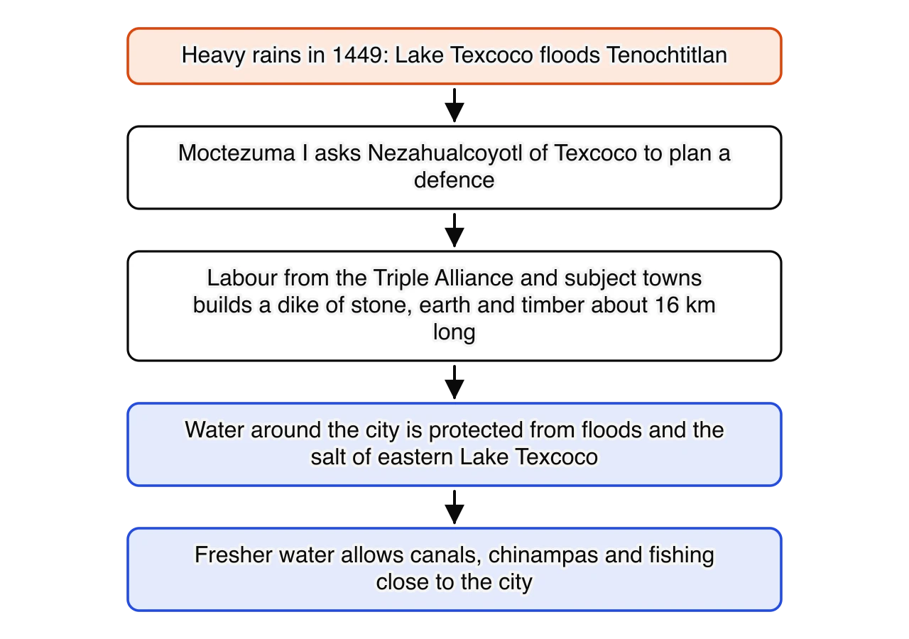
The dike did two jobs. It held back the floodwaters of the eastern lake, and it separated the salty water of Lake Texcoco from the western part of the lake around Tenochtitlan, which became known as the Lagoon of Mexico. Fed by fresh water from the springs and the southern lakes, this western lagoon became fresher over time, which allowed canals, chinampas and fishing close to the city. The causeways that joined the island to the shore also acted as dikes and had openings with bridges that controlled the flow of water between sections of the lake.
Hernán Cortés saw the lakes seventy years later and was struck by the contrast between salt and fresh water.
The large salt lake rises and falls in its tides like the sea; its waters, whenever it rises, falling into the fresh-water lake as rapidly as though it were a great river; and when it ebbs, the fresh water then runs into the salt lake.
Hernán Cortés, Second Letter to Emperor Charles V, 30 October 1520 (trans. Francis MacNutt, 1908). Cortés wrote from the town of Segura de la Frontera (Tepeaca), after his forces had been driven out of Tenochtitlan, to persuade the emperor that the city was worth winning back. His description is useful as an eyewitness account of how the lakes behaved, but he did not understand the system he was seeing: the "tides" were the result of wind and of water moving through the openings in the dikes and causeways.
The lake around Tenochtitlan was not fit to drink, so the city needed water from the springs at Chapultepec, a hill on the western shore about 5 kilometres away. An earlier channel of mud, wood and reeds had been built with Tepanec permission in the 1420s, and disputes over it were among the tensions before the Tepanec War. After the 1449 flood damaged it, Moctezuma I and Nezahualcoyotl had a new aqueduct built, of stone and mortar with two channels. Sources date its completion to about 1465–1466. Cortés described it fifty years later.
Along one of the causeways which lead to the city, there are two conduits of masonry each two paces broad, and five feet deep, through one of which a volume of very good fresh water, the bulk of a man's body, flows into the heart of the city, from which all supply themselves, and drink. The other which is empty brings the water, when they wish to clean the first conduit.
Hernán Cortés, Second Letter to Emperor Charles V, 30 October 1520 (trans. Francis MacNutt, 1908). The detail of two channels, one used while the other was cleaned, shows a system designed for continuous supply. Cortés also had a military interest in the aqueduct: he knew that cutting it would force the city to surrender, and in 1521 his forces did cut it.
The Mexica named each year by one of four signs (Rabbit, Reed, Flint Knife and House) combined with a number from 1 to 13. Since four signs and thirteen numbers combine in fifty-two ways, each year name came round once every fifty-two years, a cycle known as the xiuhmolpilli ("binding of the years"). The year One Rabbit (ce tochtli) was the first of the cycle. The year 1 Rabbit that fell in the reign of Moctezuma I corresponds to 1454.
The annals of several cities record a decade of natural disasters in the middle of Moctezuma I's reign. Because each city kept its own annals, the agreement between them on the main events is strong evidence that the disasters were real and widespread, even where they differ by a year on dates.
Year | Event recorded in the annals |
|---|---|
1446 | Swarms of locusts destroy crops |
1447 | A violent winter storm kills people, plants and animals, shown in the Codex Telleriano-Remensis |
1449 | Lake Texcoco floods Tenochtitlan |
1450–1451 | Heavy snow and frosts damage crops |
1452–1453 | Drought; an early autumn frost in 1453 kills maize before it ripens |
1454 (1 Rabbit) | The harvest fails; famine across the basin; people sell themselves for food |
1455 (2 Reed) | The famine continues in some records; recovery begins with good rains |
The annals of Chimalpahin of Chalco show how the hunger built up over several years.
This was the third year in which there was hunger. Then there was drought and hunger in Mexico.
Domingo Chimalpahin, Eight Relations (Las Ocho Relaciones), entry for 1452, written in Nahuatl in the early seventeenth century, as quoted by Therrell, Stahle and Acuña-Soto (2004). Chimalpahin was a Nahua historian from Amecameca in the Chalco region who based his annals on older painted records. Writing as a Chalcan, he had no reason to exaggerate disasters that struck Tenochtitlan; his record is valuable precisely because it is independent of the Mexica tradition.
The Annals of Cuauhtitlan, written in Nahuatl around 1570 in a town north of the lakes, use the name of the year itself to describe what happened.
At this time the people were one-rabbited, . . . And for three years there was hunger. The corn had stopped growing.
Annals of Cuauhtitlan (in the Codex Chimalpopoca), c. 1570 (trans. John Bierhorst, 1992), as quoted by Therrell, Stahle and Acuña-Soto (2004). The phrase "one-rabbited" shows that the year name had become a word for famine itself. The writer was recording a disaster more than a century earlier from older records and memory, so the exact number of years of hunger may be less reliable than the fact of the famine.
Durán gives the fullest account of how Tenochtitlan responded. Moctezuma I and Tlacaelel had the royal storehouses opened and food distributed to the people of the city, brought by canoe and prepared as maize cakes and gruel. When the stores were exhausted, according to Durán, the ruler allowed people to leave the city to find food wherever they could. Many went to the Gulf coast, where the Totonacs had maize, and sold themselves or their children into slavery in exchange for it.
The longer-term responses were political and economic. The capital tried to make sure it would never again depend only on the harvests of the basin. Tribute demands placed more weight on maize, beans and other foods that could be stored; state storehouses kept reserves; and the alliance turned its armies towards the warm, wet Gulf coast, where crops were not exposed to highland frost. The famine also had religious consequences. Priests explained the disasters as signs of the gods' anger, and in Durán's account this was the moment Tlacaelel proposed the Flower Wars to secure a steady supply of captives for sacrifice.

The famine left a long memory. A Spanish commentary in the Codex Telleriano-Remensis, written beside the entry for the next 1 Rabbit year after the conquest, 1558, records the belief that this year always brought disaster.
In this year one rabbit, if one looks carefully at this count, it will always be seen that in this year there was famine and death. . . . And thus they consider this year as a great omen, for it always falls on one rabbit.
Codex Telleriano-Remensis, annotation for 1558, mid-sixteenth century, as quoted by Therrell, Stahle and Acuña-Soto (2004). The annotator was recording Nahua beliefs for Spanish readers, possibly with some scepticism. The source shows that the famine of 1454, and another in the 1 Rabbit year of 1506, had turned the calendar into a warning a century later.
Therrell, Stahle and Acuña-Soto compared thirteen drought years named in the annals between 1332 and 1543 with tree-ring chronologies from Mexico. Nine of the thirteen were years of below-average tree growth, and on average the drought years had significantly lower growth than other years. For the years of the famine, 1452–1455, every value was below average.
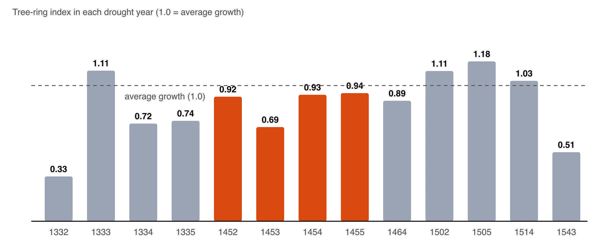
The scientists also found that in most of the 1 Rabbit years before the conquest, the year before (13 House) had below-average tree growth, which suggests that the famines feared in 1 Rabbit years often followed a failed harvest in the year before. After 1558 the pattern disappears, so the "curse" seems to have been a real but coincidental run of droughts. They concluded that the famine of 1454 was probably caused by several years of drought combined with an early autumn frost in 1453. Frost damage in the 1453 rings of bristlecone pines in the western United States points to an unusually cold autumn across much of North America that year.
The innovations of the Aztec Empire were not single inventions but systems: a planned city built on water, a method of farming the lakes, and an empire organised to move food and goods from where they grew to where they were needed. Each built on older Mesoamerican practice and took it further than before.
Tenochtitlan grew from a cluster of reed huts on a marshy island into one of the largest cities in the world. Its builders extended the island by filling in the marsh and laying out house plots and chinampas along a regular grid of canals and streets. The city was divided into four great quarters (Nahuatl campan): Moyotlan in the south-west, Teopan in the south-east, Atzacoalco in the north-east and Cuepopan in the north-west. Each quarter was made up of calpulli with their own temples, schools and markets. The four quarters met at the walled sacred precinct in the centre.
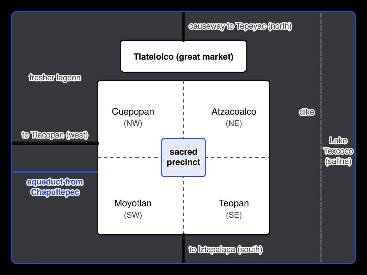
The plan expressed Mexica beliefs as well as practical needs. The four quarters matched the four directions of the world, and the sacred precinct at the meeting point was the centre of the universe in Mexica thought. The three main causeways ran from the precinct towards the north, west and south, so the roads that joined the city to the mainland began at the temple of the gods. Tlatelolco, the twin city on the north of the island, kept its own ruler until Tenochtitlan conquered it in 1473 and held the largest market.
Streets were either solid ground, canals, or half of each, so that people could walk alongside the canoes that carried goods. There were no draught animals or wheeled carts for transport in Mesoamerica, so canoes on the lakes and canals were the most efficient way to move heavy loads such as maize, stone and timber. One paddler could move far more by canoe than a porter could carry.
Its streets (I speak of the principal ones) are very broad and straight, some of these, and all the others, are one half land, and the other half water on which they go about in canoes. All the streets have openings at regular intervals, to let the water flow from one to the other, and at all of these openings, some of which are very broad, there are bridges, very large, strong, and well constructed.
Hernán Cortés, Second Letter to Emperor Charles V, 30 October 1520 (trans. Francis MacNutt, 1908). Cortés describes the city as it was in 1519, half a century after Moctezuma I, but the layout he describes was established in the period of this study. In the same passage he explains that he built ships on the lake because the raised bridges could trap his men in the city; his interest in the canals was military as well as admiring.
The Templo Mayor, the great temple at the centre of the sacred precinct, carried two shrines on one platform: one to Huitzilopochtli, god of war and the sun, and one to Tlaloc, god of rain and agriculture. The pairing summed up the two foundations of the empire, war and tribute on one side and water and harvests on the other. The temple was rebuilt and enlarged at least seven times, each new structure covering the old one. It was also aligned to the sky: the friar Toribio de Benavente (Motolinía) recorded that one festival was held when the sun rose between the two shrines, and archaeoastronomers such as Anthony Aveni have found that the building faced sunrise on dates close to the spring equinox.
Most of what is known about the temple comes from archaeology. In February 1978 electricity workers in central Mexico City found a great carved stone disc showing the dismembered goddess Coyolxauhqui. The find led to the Templo Mayor Project, directed by the archaeologist Eduardo Matos Moctezuma, which uncovered the foundations of the successive temples and more than a hundred buried offerings. The building stages can be dated by their style, their offerings and occasional carved year signs, and Stage IV is associated with Moctezuma I.
By 1519 the island city was home to a population usually estimated at between about 150,000 and 250,000 people, which made it larger than any city in Spain at the time. In 1428–1469 it was smaller, but its rapid growth explains the pressure on food and water. The market of Tlatelolco amazed the Spaniards.
There is one square, twice as large as that of Salamanca, all surrounded by arcades, where there are daily more than sixty thousand souls, buying and selling, and where are found all the kinds of merchandise produced in these countries, including food products, jewels of gold and silver, lead, brass, copper, zinc, stone, bones, shells, and feathers.
Hernán Cortés, Second Letter to Emperor Charles V, 30 October 1520 (trans. Francis MacNutt, 1908). The figure of sixty thousand is a conquistador's estimate, offered to impress the emperor, and should not be treated as a count. The list of goods is more valuable: it shows a market where food from the chinampas and the provinces met luxury goods brought by tribute and long-distance trade.
Bernal Díaz del Castillo, one of Cortés's soldiers, remembered his first sight of the city from the causeway of Iztapalapa in November 1519.
Our astonishment was indeed raised to the highest pitch, and we could not help remarking to each other, that all these buildings resembled the fairy castles we read of in Amadis de Gaul; so high, majestic, and splendid did the temples, towers, and houses of the town, all built of massive stone and lime, rise up out of the midst of the lake.
Bernal Díaz del Castillo, The True History of the Conquest of New Spain, written about 1568 (trans. John Ingram Lockhart, 1844). Díaz wrote almost fifty years after the event, as an old man in Guatemala, partly to defend the ordinary soldiers' part in the conquest against Cortés's official version. His comparison with a popular romance of chivalry shows how far the city exceeded anything the Spaniards knew, but it is a memory shaped by time and by the wish to present the conquest as a heroic achievement.
Chinampas were long, narrow fields built up from the bed of the shallow freshwater lakes. Farmers marked out a rectangle with stakes, fenced it with woven branches (wattle), and filled it with alternating layers of lake mud and water plants until it stood a little above the water. Willow trees called ahuejotes were planted along the edges; their roots bound the sides. Canals were left between the beds, so that every field was surrounded by water on most sides.
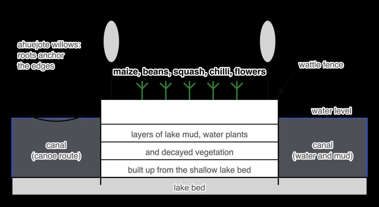
The design solved several problems at once. Water soaked up from the canals kept the soil moist through the dry season, so crops did not depend entirely on the rains. The nutrient-rich mud dredged from the canals, together with plant waste and human waste collected from the city, kept the beds fertile. Seedlings were raised in nursery beds and transplanted, which saved time in the growing season and allowed several crops a year. The surrounding water also moderated the temperature and reduced the risk of frost on the beds compared with the open hillsides.
Chinampas were not "floating gardens", although they are often called that. They rested on the lake bed and were permanent fields that could be farmed for generations. The Codex Vergara, a sixteenth-century land register from near Texcoco, suggests that typical plots measured about 30 metres by 2.5 metres; beds in and around Tenochtitlan could be larger.
Chinampas needed fresh water, so the largest areas lay in the southern lakes, Xochimilco and Chalco, which were fed by springs. This is why the conquest of the southern lake towns under Itzcoatl in the 1430s and the long war with Chalco under Moctezuma I were so important: they gave the alliance control of the most productive farmland in the basin. The dike of 1449, which made the water around Tenochtitlan fresher, allowed chinampas to spread closer to the capital. Archaeologists such as Pedro Armillas, who surveyed the southern lakes in the 1960s, found that much of the chinampa zone was laid out on a regular plan in the late Aztec period, which suggests reclamation organised on a large scale by rulers and not only by individual farming families.
 YouTube
Milpa farming. On the hillsides and plains, families grew the milpa, a field of maize, beans and squash planted together. The beans added nitrogen to the soil and the squash shaded out weeds. Amaranth, chia and chilli were also important.
Terraces. On the slopes around the basin, farmers built terraces (metepantli), banks of earth often planted with maguey (agave), which held soil and water and reduced erosion of the volcanic soils.
Irrigation. In the foothills, canals led water from springs and streams to fields, extending the growing season.
The lakes. Fish, waterfowl, frogs, the salamander axolotl, insect eggs and the blue-green algae spirulina (in Nahuatl tecuitlatl) provided protein that a diet of maize and beans otherwise lacked.
Tribute and markets. Much of the capital's food came from outside the island, through tribute paid by subject towns and through markets. The tribute lists of the Codex Mendoza record large annual payments of maize, beans, chia and amaranth, stored in the state granaries.
Historians disagree about how much of Tenochtitlan's food came from chinampas. Some archaeologists, such as Jeffrey Parsons, have estimated that the southern chinampa zone could have fed a large part of the city; others stress that tribute and market exchange supplied much of the rest. The most likely answer is that chinampas provided a reliable core of fresh food, especially vegetables and maize from several harvests a year, while tribute and trade covered the remainder and acted as insurance against bad years.
The significance of chinampas reaches beyond the period. Farmers still work chinampas at Xochimilco and San Gregorio in southern Mexico City. Xochimilco was listed by UNESCO as a World Heritage Site in 1987, together with the historic centre of Mexico City, and the United Nations Food and Agriculture Organization recognised the chinampa system as a Globally Important Agricultural Heritage System in 2018.
Totonacapan, "the land of the Totonacs", was the region of the Totonac people on the central Gulf coast, in the north and centre of the modern state of Veracruz. Its main city in the fifteenth century was Cempoala, near the coast. The region lies in the hot lowlands (tierra caliente), with heavy summer rains and no frost. It produced maize harvests when the highlands failed, as well as cotton, tropical fruit, vanilla and access to cacao-growing areas further south.
The famine of the 1450s showed how valuable this region was. According to Durán and the annals, starving people from the basin went to Totonacapan and sold themselves or their children for maize. The highland empire had discovered that its survival in a bad year might depend on a region it did not control.
In the years after the famine, Moctezuma I's armies campaigned on the Gulf coast. The Codex Mendoza lists Cuetlaxtlan (modern Cotaxtla) among his conquests, and other sources describe the submission of Totonac towns, including the region of Cempoala. The dates given range from the late 1450s to the early 1460s. Cuetlaxtlan rebelled more than once and had to be reconquered, which shows the limits of a hegemonic empire at a distance of some 300 kilometres from the capital.
Annexation followed the usual pattern. Totonac rulers stayed in place, but their towns were grouped into tribute provinces and paid regular quotas of goods to the alliance's stewards. For the empire this meant a secure supply of lowland produce, especially cotton cloth, which served as a form of currency, and food that did not depend on highland weather. It also meant control of the routes to the Gulf coast and towards the cacao lands of the south.
Before annexation | After annexation |
|---|---|
Highland famine forced people to sell themselves for Totonac maize | Lowland produce flowed to the basin as tribute |
The alliance depended on harvests in one climate zone | The empire drew on several climate zones, spreading the risk of crop failure |
Totonac towns traded with highland merchants on their own terms | Totonac towns paid fixed tribute under Mexica stewards, a source of lasting resentment |
The resentment had long-term consequences. When Cortés landed on the Gulf coast in 1519, the ruler of Cempoala complained to him about the burden of Mexica tribute and became one of his first allies. That came half a century after Moctezuma I's death, but it shows a long-term consequence of the hegemonic model: annexation gave the empire food and wealth without winning the loyalty of the annexed.
Expansion to the Gulf coast can be seen as an innovation in the management of food supply, not only as conquest. By bringing several climate zones into one tribute system, the alliance reduced its exposure to any single frost or drought in the basin. The Codex Mendoza's tribute lists show the result in the early sixteenth century: provinces sending maize, beans and other staples from the highlands, and cotton, cacao and tropical goods from the lowlands, to the same storehouses.
The three key questions lead to one larger question: how far did climate, rather than politics, drive Aztec innovation between 1428 and 1469? The evidence suggests that the two worked together, but in different roles.
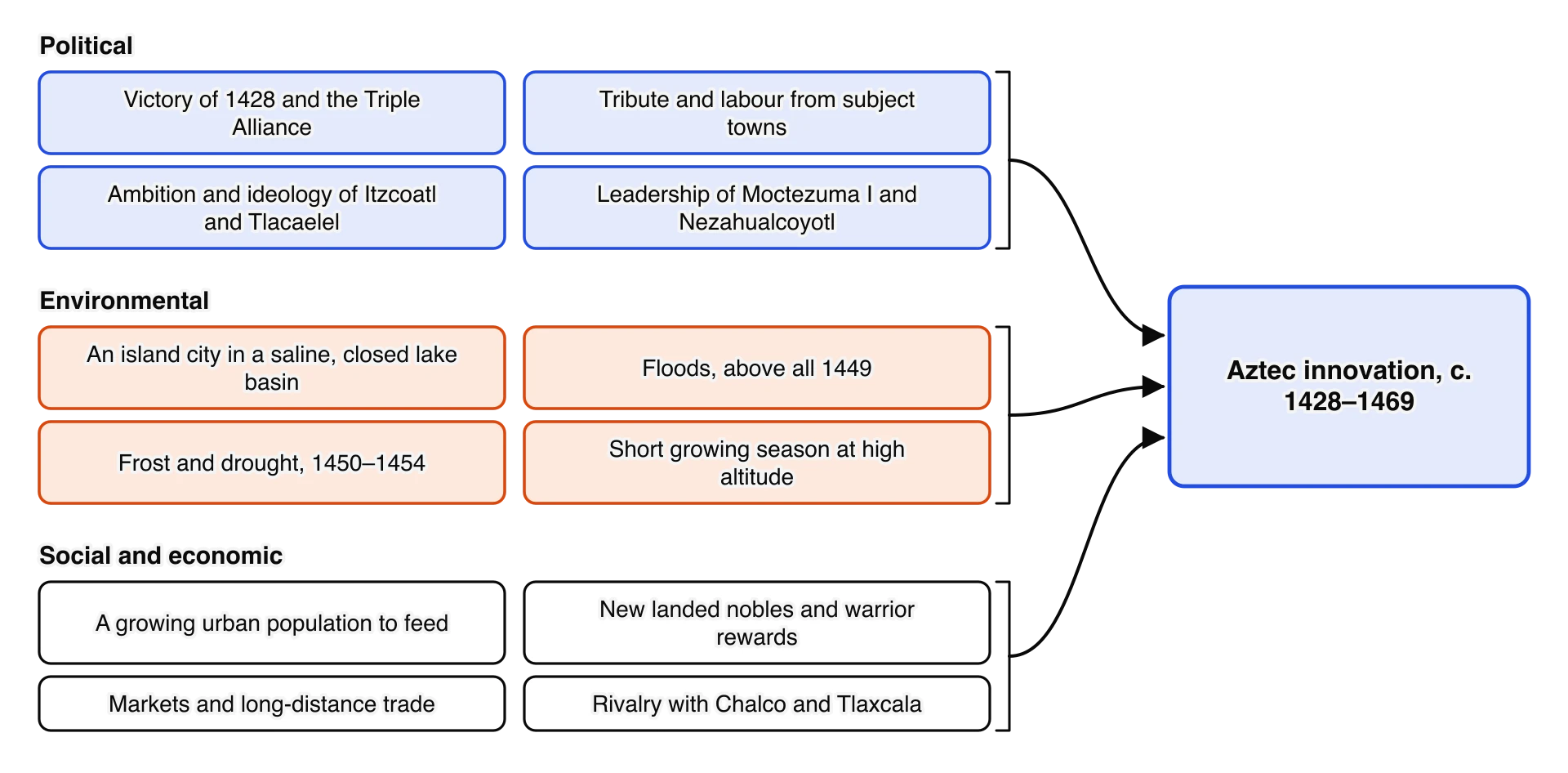
Environmental conditions set the problems. The saline lake, the floods and the frost and drought of 1449–1454 explain why the Mexica built a dike, rebuilt the aqueduct, stored food and looked to the lowlands. Political power supplied the means. Without the alliance of 1428 there would have been no tribute labour to build a 16-kilometre dike, no Texcocan engineer working for Tenochtitlan, and no armies to annex the Gulf coast. Ideology and social reform supplied motives of their own: land for nobles, captives for the gods and honour for warriors drove expansion whatever the weather.
Innovation | Environmental prompt | Political prompt | Judgement |
|---|---|---|---|
Dike of Nezahualcoyotl (1449) | Flood of 1449; salt water in Lake Texcoco | Alliance labour; Nezahualcoyotl's skill; protecting the capital | Climate the trigger; politics the means |
Stone aqueduct (c. 1465–1466) | Salty lake; damage to the old channel in 1449 | A growing capital; control of Chapultepec after 1428 | Both; the old Tepanec control of the springs shows the political side |
Chinampa expansion | Fresh southern lakes; short growing season; frost | Conquest of Xochimilco and Chalco; land grants to nobles | Mainly environmental in origin, political in scale |
Food reserves and food tribute | Famine of One Rabbit | A tribute system able to demand storable food | Climate the main prompt |
Conquest of Totonacapan | Famine showed dependence on frost-free lowlands | Imperial expansion already under way | Both; famine shaped the direction and timing |
Flower Wars | Famine as divine anger (Durán) | Stalemate with Tlaxcala; training; prestige | Mainly political and religious; the famine link is contested |
Sumptuary laws | None directly | Consolidating the new hierarchy after 1428 | Political |
The Norse in the North Atlantic, the other example of climate and innovation, faced a cold, marginal environment during the Medieval Warm Period as small farming communities with chiefs and assemblies, a story told in the study of Norse exploration (c. 982–1020). The Mexica faced frost, drought and floods as the leaders of a large, centralised tribute empire. The comparison shows how the scale of political organisation shaped the kind of innovation that was possible.
Feature | Norse (c. 982–1020) | Mexica (c. 1428–1469) |
|---|---|---|
Main climatic pressure | Cold, short summers and poor land at the northern edge of farming | Frost, variable rain, floods and salt in a high lake basin |
Political organisation | Small chiefdoms and free farmers with assemblies | A tribute empire led by three city-states |
Main response | Movement to new lands; adapting farming and trade | Large engineering works, intensive farming, conquest of other climate zones |
Sources | Sagas written about 200 years later; archaeology; ice and sediment cores | Codices and annals written after 1521; friars' histories; archaeology; tree rings |
The written record of 1428–1469 preserves the voices of particular cities and classes. The Mexica tradition behind Durán and Tezozomoc tells the story of Tenochtitlan's rise as destiny, led by Itzcoatl, Tlacaelel and Moctezuma I. Texcocan writers such as Alva Ixtlilxochitl present Nezahualcoyotl as the wise lawgiver and engineer of the alliance. Chimalpahin of Chalco records the long war with the Mexica from the side of the defeated. Tlaxcalan historians such as Diego Muñoz Camargo presented Tlaxcala as never conquered and recorded Mexica sieges of Tlaxcalan towns and a blockade of their trade, which does not fit the picture of a ritual contest.
Other voices are largely missing. Commoners, women, slaves and the peoples of the conquered provinces appear mostly as tribute payers, labourers or victims of famine. The Totonacs who bought starving highlanders, and the families who sold their children, are known only through highland and Spanish writers. Archaeology of households and fields, and the tribute lists themselves, are the main ways historians recover their experience.
Historian | Work | Argument | Evidence stressed |
|---|---|---|---|
Miguel León-Portilla | Aztec Thought and Culture (1963; Spanish 1956) | Tlacaelel created a mystical and militaristic world view that made the Mexica the people of the sun, bound to feed it through war and sacrifice | Nahuatl texts, Durán's account of Tlacaelel, the burning of the old histories |
Geoffrey Conrad and Arthur Demarest | Religion and Empire (1984) | The state religion of sacrifice reformed after 1428 drove constant expansion, which made the empire powerful but unstable | The link between captives, sacrifice and warrior rank; the Templo Mayor |
Ross Hassig | Aztec Warfare (1988) | The empire was hegemonic and followed political and economic logic: indirect rule kept costs low; wars, including Flower Wars, were chosen for strategic reasons | Logistics, distances, garrisons, conquest lists |
Michael E. Smith | The Aztecs (3rd edn, 2012) | The empire rested on a productive commercial economy of markets, households and provinces, not only on tribute and war | Excavations of houses and towns outside the capital; markets; regional archaeology |
Camilla Townsend | Fifth Sun: A New History of the Aztecs (2019) | Read in Nahuatl, the annals show politicians making choices, not a people driven by destiny or blood-lust; Spanish sources distorted them | Nahuatl annals by Indigenous writers, including Chimalpahin |
Matthew Therrell, David Stahle and Rodolfo Acuña-Soto | "Aztec drought and the curse of One Rabbit" (2004) | The droughts in the annals, including the famine of 1454, were real climatic events that tree rings confirm | Tree-ring chronologies compared with thirteen drought years in the annals |
These views differ mainly in what they treat as the motor of the empire. León-Portilla and Conrad and Demarest stress ideas; Hassig stresses strategy; Smith stresses the economy; Townsend stresses political choices recorded in Indigenous sources; Therrell and his colleagues add environmental shocks. A strong judgement uses them together. The climatic disasters of the 1450s are firmly established, but the way the empire responded to them, through engineering, tribute, conquest and new rituals, depended on its political structure and its beliefs.
Environmental explanations of Aztec history, a form of environmental determinism when pushed too far, have a mixed record. In 1977 the anthropologist Michael Harner argued that the Mexica practised sacrifice on a large scale because the basin lacked animal protein. Barbara Price and others rejected the argument: maize and beans together provide adequate protein, and the lakes supplied fish, birds and insects. Famine, not a constant lack of protein, was the real environmental danger. The debate is a warning against explaining a whole culture by its environment. Climate explains when and where particular pressures arose; it does not explain the choices people made in response.
Focused study 1: Climate and innovation. The Aztec Empire (circa 1428–1469). A practice set in the style of the IB. Using the three sources and considering the overarching inquiry question "To what extent was the famine of One Rabbit the main factor prompting Aztec innovation?", answer the three questions that follow.
Source A: Matthew Therrell and David Stahle, geoscientists, and Rodolfo Acuña-Soto, an epidemiologist, in the scientific article "Aztec drought and the 'curse of One Rabbit'", Bulletin of the American Meteorological Society (2004).
Famine occurred in 1454 and 1505 and Tenochtitlan apparently relied on maize imports from the Gulf Coast area of Veracruz. Rainfall and crop yields in Veracruz during 1454 and 1505 were presumably better and a more complete tree-ring network could be used to test this hypothesis. . . . The famine of 1454 appears to have been caused by both a multiyear drought and an early autumn frost in 1453.
Source B: Hernán Cortés, Spanish conquistador, in a letter to Emperor Charles V, the Second Letter (30 October 1520), describing Tenochtitlan as he saw it in 1519–1520 (trans. Francis MacNutt, 1908).
Along one of the causeways which lead to the city, there are two conduits of masonry each two paces broad, and five feet deep, through one of which a volume of very good fresh water, the bulk of a man's body, flows into the heart of the city, from which all supply themselves, and drink. . . . Conduits as large round as an ox's body bring the fresh water across the bridges, thus avoiding the channels by which the salt-water flows, and in this manner the whole city is supplied, and everybody has water to drink.
Source C: Diego Durán, Dominican friar, in the history The History of the Indies of New Spain (completed 1581), based on a lost Nahuatl chronicle of Tenochtitlan. Adapted summary of his chapters on the famine in the reign of Moctezuma I.
Durán describes years of frost and failed harvests in the reign of Moctezuma I, which grew into a great famine. Moctezuma and his adviser Tlacaelel had the royal storehouses opened and fed the people of the city for as long as the grain lasted. When it ran out, the ruler allowed the people to leave and look for food elsewhere, and many sold themselves or their children for maize to the peoples of the Gulf coast. Durán reports that the priests blamed the disasters on the anger of the gods, and that Tlacaelel then proposed regular, pre-arranged wars against Tlaxcala, Huexotzinco and nearby cities, so that captives for sacrifice could be taken close to home whenever they were needed.
This task uses the passage from the Florentine Codex on the burning of the old histories under Itzcoatl, quoted with Itzcoatl's reforms, and the inquiry question "To what extent did political change after 1428 prompt Aztec innovation?"
I can explain the terms Mexica, Aztec, Triple Alliance, altepetl, tlatoani and calpulli, and why historians use them as they do.
I can describe the kinds of source that survive for 1428–1469 and explain why almost all written sources date from after 1521.
I can explain how the context of Durán, the Florentine Codex, the Codex Mendoza, Cortés and Díaz affects their use as evidence.
I can narrate the Tepanec War and explain how the Triple Alliance was formed and how it shared power and tribute.
I can explain Itzcoatl's reforms, including the land grants and the burning of the old histories, and their significance.
I can describe how the tribute empire worked and explain why it is called hegemonic.
I can describe the social hierarchy and explain how warriors could rise through taking captives.
I can explain what the Flower Wars were and compare the interpretations of Durán, Hicks, Isaac and Hassig.
I can assess the role and significance of Moctezuma I in conquest, law and building.
I can describe the environment of the Basin of Mexico and explain why Lake Texcoco was salty while the southern lakes were fresh.
I can explain the purpose of the dike of Nezahualcoyotl and the aqueduct from Chapultepec.
I can explain the year One Rabbit and narrate the disasters of 1446–1455 and the responses to the famine.
I can explain how tree rings are used to test the annals and what their limits are.
I can describe the plan of Tenochtitlan and explain how it combined religious meaning and practical needs.
I can explain how chinampas were built and why they were so productive, and how other methods and tribute supplied food.
I can explain why Totonacapan was annexed and what annexation meant for both sides.
I can reach a supported judgement on how far climate, rather than politics, prompted Aztec innovation, and compare the Mexica with the Norse.