Explain why the Norse sailed west from Iceland to Greenland and Vinland between about 982 and 1020, how climate shaped their voyages, and what new settlements, food production and trade they created.
Each is in the History glossary, with every other term in the subject.
The national assembly of Iceland, founded in 930, which met each summer at Thingvellir to make law and settle disputes; it adopted Christianity in 999 or 1000.
Land that can be ploughed and used to grow crops; in the Norse North Atlantic, meadow and pasture for hay mattered as much as fields.
Iron ore that forms in bogs and wetlands, which the Norse smelted in small furnaces to make iron, as at L'Anse aux Meadows.
A free farmer in Norse society: the head of a household who owned or rented land, could bear arms and had the right to speak at the thing.
A cowshed; in Norse Greenland, cattle were kept in turf-walled byres for up to seven months and fed on stored hay.
A way of building a wooden hull from overlapping planks riveted together along their edges, starting from the keel, which gives a light, strong and flexible ship.
An Arctic people who lived in parts of Arctic Canada and Greenland before the Thule; the ruins the Norse found in Greenland may have been theirs or those of even earlier cultures.
Sea ice that moves with currents and winds; ice from the Arctic drifts down Greenland's east coast and around Cape Farewell, and when heavy it blocks shipping.
Norse exploration of the North Atlantic carried European settlers further west than anyone had gone before: to Greenland in the 980s and to the coast of North America around the year 1000, nearly five hundred years before Columbus. It is a study of how a small farming society responded to shortages of land, used its ship technology and a favourable climate, and adapted its way of life to new environments.
With a free account, Augment remembers where you stopped and what you have practiced.
The larger of the two Norse settlement districts in Greenland, around Eiriksfjord near the southern tip of the island, founded about 985 and abandoned by about 1450.
The view that the natural environment (climate, geography, resources) decides how societies develop; most historians reject strong versions of it.
A system in which leaders gave land, food, protection and gifts to followers in return for loyalty and support, binding them together through obligations.
A chieftain in medieval Iceland who led religious rites and represented his followers at assemblies; Iceland had about three dozen.
A long cylinder of ice drilled from an ice sheet, whose layers preserve chemical evidence of past temperatures and volcanic eruptions.
The enclosed, manured land next to a Norse farmhouse, kept for growing hay to feed animals through the winter.
A new technology, technique, institution or practice that people actually adopt and use, as distinct from an idea that is only thought of.
The Book of the Icelanders, a short history of Iceland written by the priest Ari Thorgilsson in about 1122–1133; it contains the earliest account of Erik the Red's settlement of Greenland.
The strong timber running along the bottom of a ship's hull, which gives it strength and keeps it on course under sail.
A deep, broad Norse ocean-going cargo ship that relied mainly on its sail and needed a small crew; it carried settlers, livestock and goods across the North Atlantic.
Old Norse for "land-taking": the first settlement of an empty land, used especially for the settlement of Iceland between about 870 and 930.
The Book of Settlements, a record compiled in Iceland in the twelfth and thirteenth centuries of the first settlers of Iceland, their families and their land, with some information on Greenland.
A method of navigation in which sailors judge their latitude from the height of the sun or the Pole Star, reach the latitude of their destination and then sail due east or west along it.
A long, narrow Norse warship powered by many oars and a sail, carrying a large crew for raiding and war.
A period of about 950–1250 when the North Atlantic and many other regions were warmer than in the centuries before and after, with large regional differences in rainfall; scientists now often call it the Medieval Climate Anomaly because the change was uneven.
The medieval Scandinavian peoples of Norway, Denmark and Sweden and the communities they founded overseas, such as Iceland and Greenland, who spoke Old Norse.
A pattern of changing air pressure between Iceland and the Azores that affects the strength of westerly winds and the weather of the North Atlantic and Europe.
The most serious punishment in Norse law, removing the protection of the law from a person: lesser outlawry meant three years' exile, full outlawry meant anyone could kill the outlaw without penalty.
Natural records such as ice cores, tree rings, pollen and sediments that preserve evidence of past climate where there are no instrument readings.
A scientific method that estimates when a once-living thing died by measuring the decay of carbon-14 in it; a known spike in carbon-14 in tree rings can give an exact year.
A prose narrative written in medieval Iceland, mostly in the thirteenth and fourteenth centuries, about the kings of Norway or early Icelanders and their families, drawing on oral tradition.
A hut on an outlying summer pasture, used while animals grazed away from the home farm so that the meadows near the house could grow hay.
The Old Norse name for the Indigenous peoples of Greenland and North America met by the Norse; its original meaning is uncertain and it was not a name these peoples used for themselves.
Five eleventh-century ships sunk to block a channel in Roskilde Fjord, Denmark, and raised in 1962; they include an ocean-going knarr built in western Norway in about 1030.
A soured, strained milk product made in Norse Iceland and Greenland, which could be stored through the winter.
Measuring the ratios of carbon and nitrogen isotopes in bone to work out what kinds of food, for example marine or land-based, a person ate.
A possible Norse navigation instrument: a disc on which the shadow of a pointer showed direction. A broken wooden disc found at Uunartoq in Greenland in 1948 may be one, but this is debated.
An assembly of free men in Norse society that met at fixed times to settle disputes and make laws.
An enslaved person in Norse society, often captured in raids abroad, with no legal rights.
The ancestors of the modern Inuit, who spread east across Arctic Canada and reached northern Greenland in the thirteenth century.
In the original sense, a Scandinavian who went on a raiding or trading expedition by sea; now often used loosely for all Scandinavians of the Viking Age, most of whom were farmers.
The period of Scandinavian raiding, trade and settlement overseas, usually dated from the raid on Lindisfarne in 793 to about 1066.
The smaller, more northerly Norse settlement district in Greenland, in the fjords near modern Nuuk, founded about 985 and abandoned by about 1360.
The Norse were the Scandinavian peoples of what are now Norway, Denmark and Sweden, and the communities they founded overseas, who spoke Old Norse. Most were farmers. Some also traded, and some raided: a Viking was, in the original sense of the word, a man who went "a-viking", on a raiding or trading expedition by sea. Historians usually date the Viking Age from the raid on the monastery of Lindisfarne in northern England in 793 to about 1066, when the Norwegian king Harald Hardrada was defeated at Stamford Bridge.
Expansion took several forms. Danes and Norwegians raided, conquered and settled in Britain, Ireland and Normandy; Swedes travelled east along the rivers of Russia to Byzantium. The westward movement across the North Atlantic was different in kind. It was a movement of farming families with their animals, looking for land, into islands that were empty or almost empty of people: the Faroes in the early ninth century, Iceland from about 870 and Greenland from the 980s.
Norse society was built around the farm and the household. The head of a household was the free farmer, or bóndi (plural bændr), who owned or rented land, kept weapons and had the right to speak at assemblies. Above the farmers stood chieftains, whose power rested on wealth, land and the number of followers they could feed and protect. Below them were thralls, enslaved people who had no legal rights; many had been captured in raids on Ireland and Britain.
Group or institution | Who or what | Role in the westward expansion |
|---|---|---|
Bóndi (free farmer) | Head of a farming household, with the right to bear arms and attend the thing | The typical settler: needed land for a family, livestock and hay |
Goði (chieftain, Iceland) | A chieftain who also led religious rites and represented his followers at assemblies; Iceland had about three dozen | Chieftains organised voyages and claimed large estates in new lands, as Erik did in Greenland |
Thrall | An enslaved person, often captured abroad | Provided labour on the first farms; slavery declined in Iceland in the eleventh century |
Thing | An assembly of free men that settled disputes and made law | Courts at the thing could outlaw a man, as happened to Erik in about 982; Greenland later had its own thing |
A thing was an assembly of free men that met at fixed times to settle disputes and make law. Iceland had no king. In 930 its chieftains founded the Althing, a national assembly that met each summer at Thingvellir. Without a king or police, the law worked through feud and compensation: a killing had to be paid for in money or answered with another killing, and a court could punish a man with outlawry, which removed the protection of the law from him.
Relations between chieftains and followers depended on gift exchange and reciprocity. A leader gave land, food, protection and gifts; followers gave loyalty, labour and support at the thing. A man who wanted to become a chieftain needed land to give away, and new land was easiest to find in a new country. This helps explain why a defeated or outlawed chieftain might see a colony as a way to rebuild his position.
Religion was changing during the period. The early settlers of Iceland worshipped the Norse gods, though some were already Christian. In 999 or 1000 the Althing agreed that all Icelanders should be baptised, under pressure from the Norwegian king Olaf Tryggvason. The Saga of Erik the Red credits Leif Eriksson with bringing Christianity to Greenland at about the same time, at Olaf's request. The settlers who sailed with Erik in the 980s were therefore mostly pagan; their children were Christian.
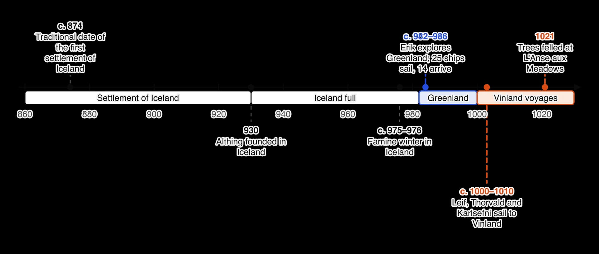
Iceland was the model and the launch pad for everything that followed. Norse sailors reached it in the 860s, and tradition dates the first permanent settler, Ingólfr Arnarson, to 874. Over the next sixty years thousands of settlers, mostly from western Norway and from Norse communities in Britain and Ireland, claimed land. This period is called the landnám ("land-taking").
Icelandic tradition, written down in the twelfth and thirteenth centuries, says that many settlers fled the tyranny of Harald Fairhair, the king who was uniting Norway in the late ninth century. Modern historians treat this as partly a founding myth: Icelanders liked to see their ancestors as free men who refused to bow to a king. The steady demand for farmland in the crowded fjords of western Norway was probably at least as important.
The timeline of the westward expansion shows why the period of this study begins in the 980s. By about 930 all the good land in Iceland had been claimed, according to Ari Thorgilsson's Íslendingabók (Book of the Icelanders, written about 1122–1133). Later arrivals and younger sons had to take poorer land in the uplands or work for others.
In this study an innovation means a new way of doing things that people adopted in response to a problem or an opportunity: new routes across the ocean, new settlements in unfamiliar environments, new ways of producing food and new trading contacts. Three factors explain why the Norse undertook these innovations when they did: pressure on land at home, the ships and seamanship that made long voyages possible, and the ambitions of particular leaders.
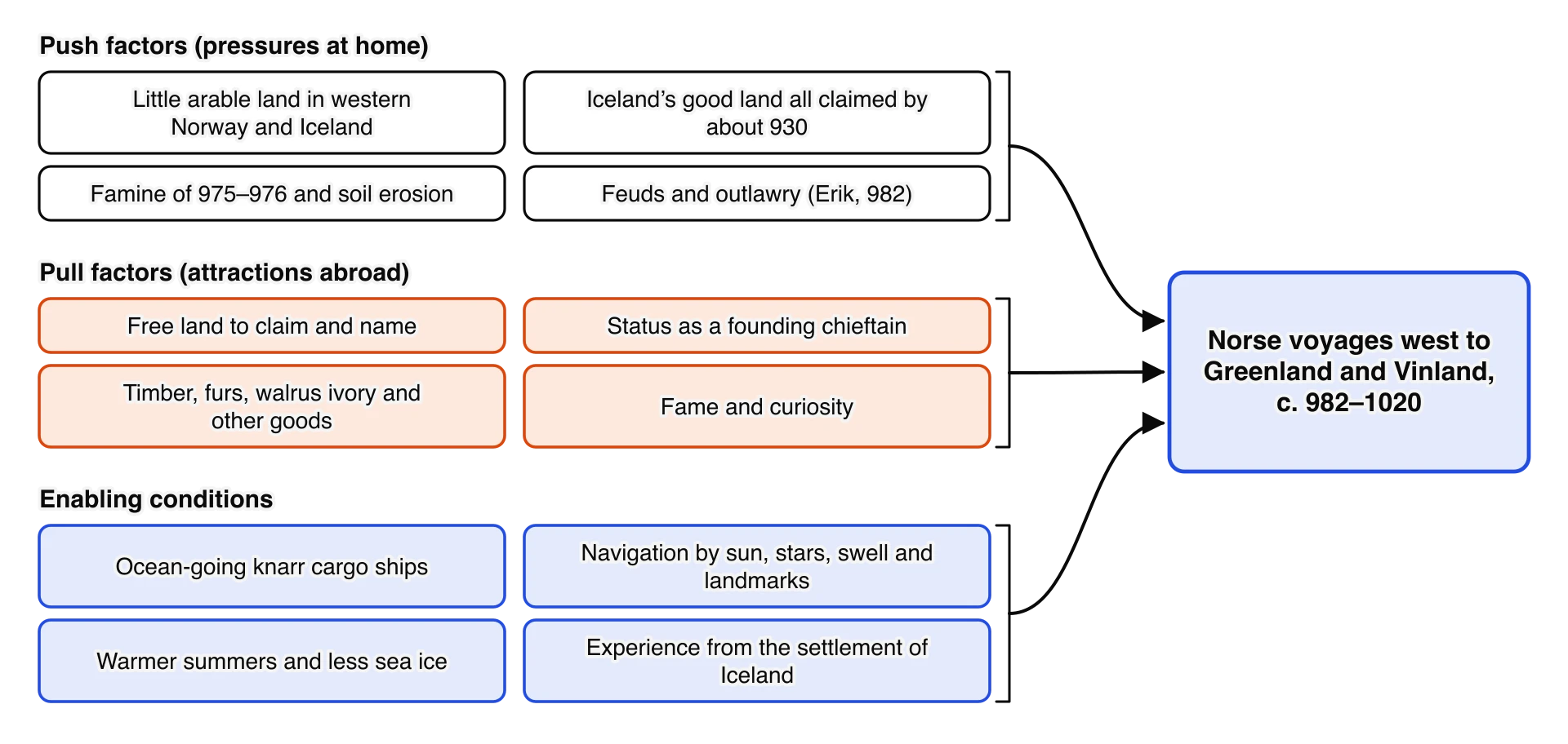
The diagram of push factors, pull factors and enabling conditions separates three different questions. Push factors explain why people were willing to leave their homes. Pull factors explain why they chose particular destinations. Enabling conditions explain why the voyages were possible at all. Many arguments about the "main" cause of Norse exploration are really arguments about which of these questions matters most.
Scandinavia had little land suitable for growing crops. Western Norway, where most Iceland settlers came from, is a coast of steep mountains and narrow fjords; even today only about 3 per cent of Norway's land area is farmland. A farm needed hay meadows as well as fields, to feed animals through a winter of six or seven months, and good meadows were limited. As the population grew in the eighth and ninth centuries, younger sons and ambitious men looked overseas.
Iceland relieved the pressure for two or three generations, but its good land was soon taken. The settlers cleared the birch woodland that had covered much of the lowlands, for fuel, building and grazing. Without trees, the thin volcanic soils were exposed to wind and grazing animals, and erosion began within a few generations. The Icelandic annals, compiled from the late thirteenth century onwards, record a severe famine in about 975–976; the date is approximate, and the annals give no figures for its effects. By the 980s, an Icelander who wanted a large farm and had no inheritance had few options at home.
The settlers who followed Erik to Greenland in about 985 came from the crowded west of Iceland, from Breidafjord and Borgarfjord. Many were from families of modest standing, and archaeological work in the Western Settlement suggests that not all were wealthy farmers: some had to accept poorer land and depended on richer neighbours. For them Greenland offered the chance to claim land that was unavailable in Iceland.
Land shortage is the strongest explanation of why hundreds of people were ready to go to Greenland. It is weaker as an explanation of the Vinland voyages. Greenland in the year 1000 had plenty of unused land for a few hundred settlers, yet its leading families still sent expeditions to North America. Those voyages were driven more by the search for timber and other goods, by curiosity and by the prestige of discovery. Land shortage also explains why people left, not why they chose such a distant and difficult destination; for that, the role of leaders and the reports of new land matter more.
Scandinavian shipbuilders had developed a distinctive kind of hull over several centuries. In clinker construction, the hull is built up from the keel with long, thin planks that overlap like roof tiles and are fastened to each other with iron rivets. Ribs are added afterwards to stiffen the shell. The result is a hull that is light, strong and slightly flexible, so it rides over waves instead of fighting them, and it draws little water, so it can be beached or brought up shallow rivers.
The sail arrived late in Scandinavia. Rowing boats such as the Nydam boat (about 320 CE) have no mast. Sails were adopted in the eighth century, and by the time of the Oseberg ship (built about 820) and the Gokstad ship (built about 890), both found in burial mounds in Norway, Norse ships carried a single large square sail of wool on a mast set into a heavy block on the keel. The combination of a keel and a sail turned a coastal rowing boat into a vessel that could cross open sea.
From the tenth century shipbuilders produced specialised types. The long, narrow longship carried a large crew of oarsmen and warriors at speed. The knarr was a deep, broad cargo ship that relied on its sail, with only a few oars for manoeuvring in harbour. It had an open hold amidships for goods, livestock and fodder, and needed a crew of only six to eight. It was the knarr, not the longship, that carried settlers to Greenland and Vinland.
Feature | Longship (warship) | Knarr (ocean-going cargo ship) |
|---|---|---|
Shape | Long and narrow; low sides | Short, broad and deep; high sides for the open sea |
Power | Oars along the whole length, plus a sail | Sail; only a few oars for harbour work |
Crew | Large: 25 to 60 or more oarsmen and warriors | Small: about 6–8 |
Purpose | Raiding and war in coastal waters | Carrying people, livestock, fodder, timber and trade goods across the ocean |
Example | Skuldelev 2 (about 30 m long; built near Dublin, about 1042) | Skuldelev 1 (about 16 m long; built in western Norway, about 1030) |
Data: Viking Ship Museum, Roskilde; Ole Crumlin-Pedersen, "Ship Types and Sizes AD 800–1400" (1991).
The best archaeological evidence for the knarr comes from the Skuldelev ships, five vessels that were filled with stones and sunk to block a channel of Roskilde Fjord in Denmark in the later eleventh century. They were raised in 1962 and are displayed at the Viking Ship Museum in Roskilde. Skuldelev 1 is an ocean-going cargo ship built of pine in western Norway in about 1030. It is a few decades later than Erik's voyage, but it shows the kind of ship that sailed the North Atlantic routes.
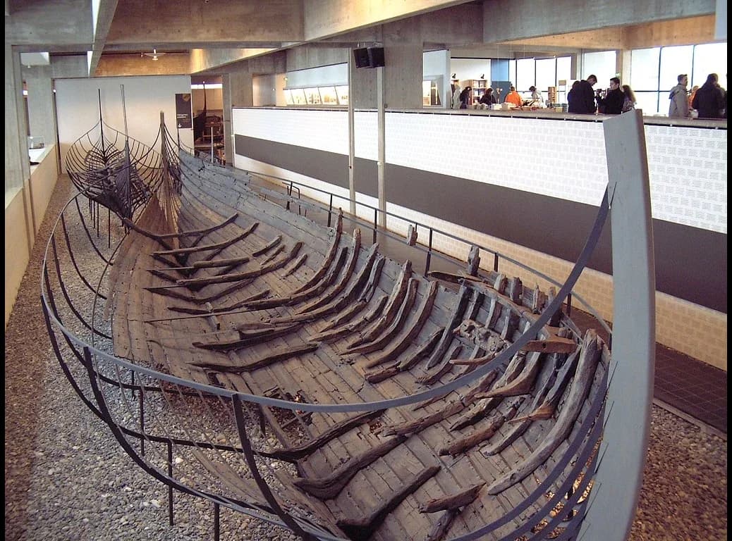
Modern reconstructions show what these ships could do. A full-size copy of Skuldelev 1, Saga Siglar, sailed around the world between 1984 and 1986. Trials with replicas have recorded speeds of more than 10 knots with a following wind and shown that a knarr could sail at about 60 degrees to the wind. A day's sail in good conditions could cover well over 100 nautical miles, which put Greenland within a few days' sailing of Iceland.
 YouTube
Norse sailors had no magnetic compass and no charts. They practised a form of latitude sailing: they judged their latitude from the height of the sun at midday or of the Pole Star at night, sailed north or south to the latitude of their destination and then held a course due east or west. They read the sea as well as the sky, using the direction of the swell, the colour of the water, driftwood, seabirds and whales to judge their position and the nearness of land.
The Landnámabók (Book of Settlements), compiled in Iceland in the twelfth and thirteenth centuries, preserves sailing directions of this kind. In one version, a ship bound from western Norway to Greenland is told to sail due west, passing north of Shetland so that it can only just be seen in clear weather, south of the Faroes so that the sea appears halfway up their mountains, and south of Iceland at such a distance that its birds and whales can be seen. The directions describe a route by landmarks and signs of life, not by measured distances.
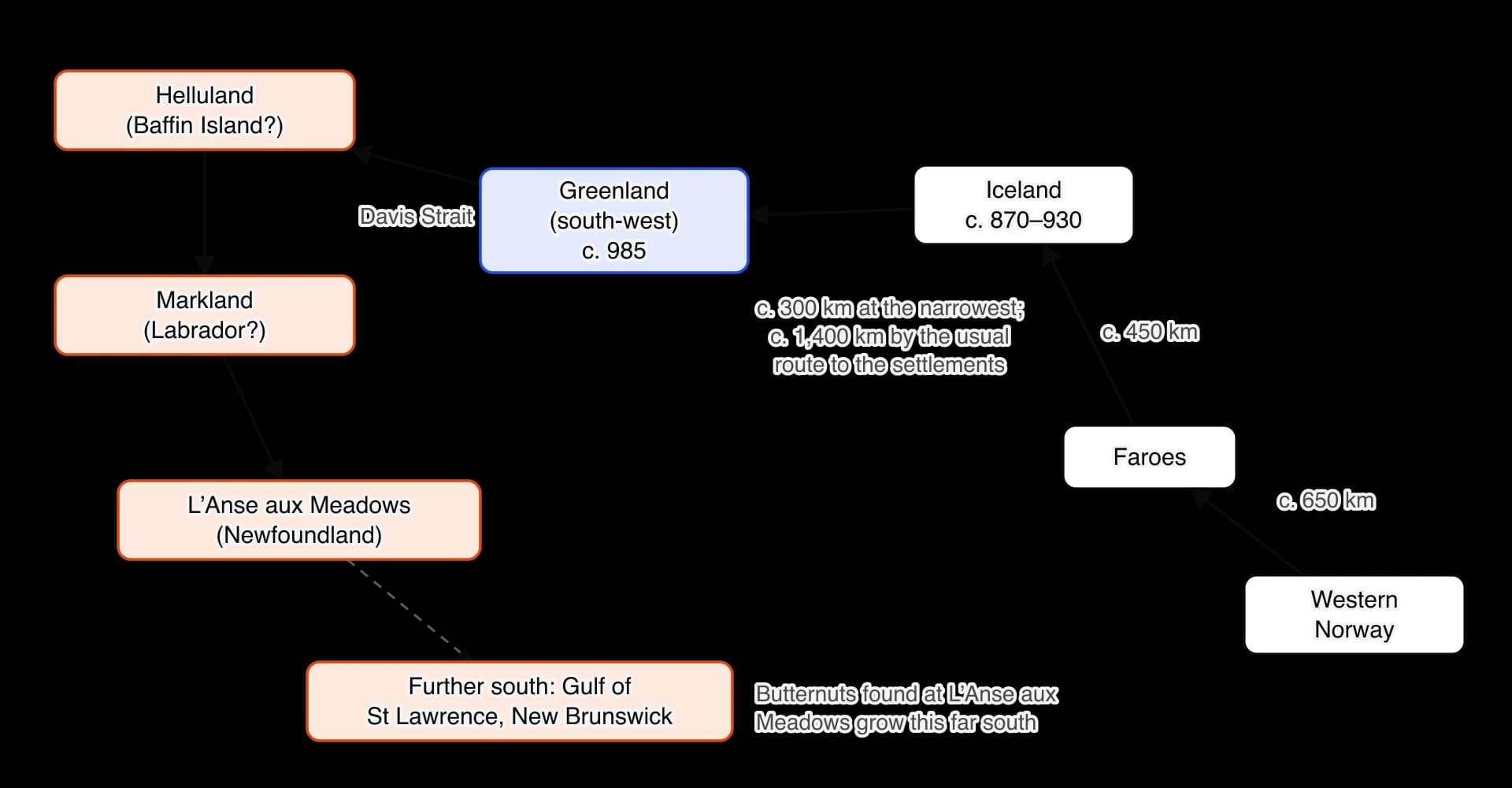
The schematic map of the North Atlantic route shows why this kind of navigation was enough. The islands lay close enough together that each was found from the one before: the Faroes from Norway, Iceland from the Faroes, Greenland from Iceland, and the lands across the Davis Strait from Greenland. A navigator who could hold a latitude and read the signs of land never had to cross more than about a week of open sea.
Two possible instruments are debated. In 1948 archaeologists found half of a small wooden disc with notches around its edge at Uunartoq in southern Greenland. Some researchers interpret it as a sun compass, a disc whose gnomon cast a shadow that could show direction; others think it may have had another purpose. Later sagas also mention a "sunstone", possibly a crystal of Iceland spar that can locate the sun through cloud by polarising light. Experiments show that such a crystal can work, but there is no direct evidence that it was used in this period.
Ship technology was a necessary condition for exploration: without the knarr, families with livestock could not have crossed to Iceland and Greenland. But the technology did not change much between the settlement of Iceland in the 870s and the voyages of the 980s, so it cannot explain why the westward movement happened when it did. It made voyages possible; the decision to go depended on other factors. There is also a link in the other direction. The voyages created a demand for ships, and Greenland's lack of timber later made its settlers depend on ships from Norway and on wood fetched from Markland.
Erik Thorvaldsson, known as Erik the Red (probably from the colour of his hair), was born in south-west Norway in about 950. His father Thorvald was banished from Norway after killings, and the family settled on poor land at Drangar in the far north-west of Iceland, which had been settled long before they arrived. After his father's death, Erik married Thjodhild, the daughter of a well-connected family, and moved south to Haukadal. There he killed two men in a quarrel and was forced to leave the district.
Erik moved to the islands of Breidafjord, where a new feud began over carved bench-boards that he had lent to his neighbour Thorgest and could not get back. Men on both sides were killed. In about 982 the Thorsness thing sentenced Erik to lesser outlawry: three years' exile from Iceland. Instead of returning to Norway, Erik sailed west to look for land that a sailor named Gunnbjörn Ulfsson had sighted decades earlier, when storms drove him west of Iceland.
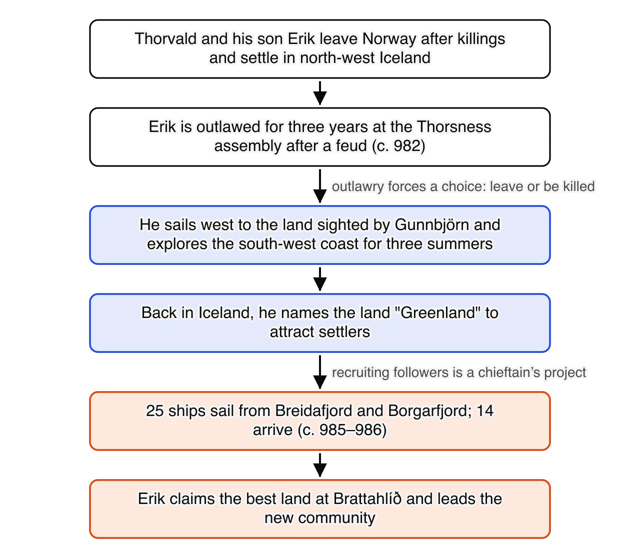
The chain of events from Erik's exile to the founding of Greenland shows how a personal crisis became a colony. For three summers Erik explored the south-west coast of Greenland, naming fjords and landmarks after himself and choosing the best sites. He found sheltered fjords with grassland, which were far from the ice cap and much like the Iceland he knew. When his outlawry ended, he returned to Iceland to recruit settlers. The earliest written account, by Ari Thorgilsson, describes the name he chose.
The land called Greenland was discovered and settled from Iceland. Eirik the Red was the name of the man from Breidafjord who went there and took that land there which is called Eiriksfjord. He gave the land a name and called it Greenland, saying that if it had a good name, people may want to go there.
Ari Thorgilsson, Íslendingabók (Book of the Icelanders), written about 1122–1133; translation by Birgitta Wallace. Ari was a priest who wrote a short, careful history of Iceland and named his informants. One of them was his uncle Thorkel Gellisson, who had talked to a man who sailed to Greenland with Erik, so this passage is only two steps from an eyewitness. It is the earliest Icelandic account of Erik and the most trustworthy on the basic facts, and it presents the name as a deliberate means of persuading settlers.
Erik's campaign worked. Landnámabók records how many ships followed him in about 985 or 986.
That summer twenty-five ships sailed to Greenland out of Borgfirth and Broadfirth; but fourteen only reached their destination; some were driven back, and some were lost.
Landnámabók (Book of Settlements), quoting Ari Thorgilsson; translation in J. E. Olson and E. G. Bourne (eds), The Northmen, Columbus and Cabot, 985–1503 (1906). The figures show the scale of the migration (perhaps several hundred people on the ships that arrived) and its risks: more than two in five ships turned back or sank. The book is a genealogical record compiled to show which families owned which land, so its value lies in names, places and numbers more than in motives.
Erik took the best land, at Brattahlíð in Eiriksfjord (near modern Qassiarsuk), and his followers took the other fjords, each named after its first settler. As the founder of the colony, he had the status of a great chieftain: he distributed land, led the community and hosted its feasts. The same pattern of a leader recruiting followers with the promise of land had been used in the settlement of Iceland. Erik's innovation was to apply it to a land that no Norse family had yet seen.
According to the Saga of the Greenlanders, the first European to see North America was a merchant, Bjarni Herjólfsson. In about 986 he sailed from Norway to Iceland to spend the winter with his father, as usual, only to find that his father had gone with Erik to Greenland. Bjarni followed, although none of his crew had sailed that route. Fog and north winds drove the ship far off course. When the weather cleared, the crew saw land that was "level, and covered with woods", which Bjarni was sure was not Greenland. He sailed on past this land and two more before reaching Greenland.
At the second land his crew wanted to go ashore for wood and water, but Bjarni refused, which "won him blame among his shipmates" in the words of Arthur Middleton Reeves's 1890 translation. The Saga of the Greenlanders, written about 1200–1230 and preserved only in the manuscript Flateyjarbók (1387–1394), criticises Bjarni for his lack of curiosity, which sets up Leif as the bold explorer who completed the discovery. The story shows what thirteenth-century Icelanders admired; it cannot prove that the sighting happened, since no other source mentions Bjarni.
Leif Eriksson ("the Lucky"), Erik's eldest son, grew up in Greenland. In about 999 he sailed to Norway, where he was baptised at the court of King Olaf Tryggvason. The two sagas disagree about what happened next. In the Saga of Erik the Red, Leif was blown off course on the way home and found a land of self-sown wheat and grapes by accident. In the Saga of the Greenlanders, Leif bought Bjarni's ship, collected a crew of 35 and set out on purpose to find the lands that Bjarni had seen. Erik was to lead the expedition, but his horse stumbled on the way to the ship and he took it as a sign that he should stay at home.
The Saga of the Greenlanders describes Leif's voyage in the order in which he reached the lands Bjarni had seen.
They sailed up to the land and cast anchor, and launched a boat and went ashore, and saw no grass there; great ice mountains lay inland back from the sea, and it was as a [tableland of] flat rock all the way from the sea to the ice mountains, and the country seemed to them to be entirely devoid of good qualities. Then said Leif, "It has not come to pass with us in regard to this land as with Biarni, that we have not gone upon it. To this country I will now give a name, and call it Helluland."
Grœnlendinga saga, translation by Arthur Middleton Reeves (1890). The extract judges each land by what a farmer needs, grass and timber, and shows that naming was an act of claiming, just as Erik's naming of Greenland had been. The saga was written two centuries after the event by Icelanders who wanted to honour Leif and his family, which shapes its picture of a decisive leader.
Leif named the second land Markland ("forest land") after its woods, and the third Vinland ("wine land"). In Vinland his crew built houses, later called Leif's booths (Leifsbúðir), and spent the winter, then returned to Greenland with a cargo of timber and, the saga says, grapes. After Erik died, Leif became the head of Brattahlíð and the leading man in Greenland. He did not sail to Vinland again, but he lent his houses there to the expeditions that followed.
Erik the Red | Leif Eriksson | |
|---|---|---|
What he did | Explored south-west Greenland (c. 982–985), named it, recruited settlers and founded the colony (c. 985–986) | Led the first landing in North America (c. 1000), named Helluland, Markland and Vinland, and wintered there |
Why it mattered | Turned land hunger in Iceland into a planned migration; created the base from which all later voyages sailed | Showed that the lands to the west could be reached and used; his houses became the base for later expeditions |
Limits of his role | Built on decades of Norse ocean sailing, Gunnbjörn's sighting and the settlement model of Iceland | Followed Bjarni's route (in one saga); did not settle Vinland; the attempt to colonise was led by Karlsefni |
How the sources treat him | Ari presents him as a practical founder; the sagas add a violent, proud and stubborn pagan | Both sagas present him as lucky, brave and a bringer of Christianity, partly because his family were heroes to later Icelanders |
Both men mattered most as organisers. Erik's decision to recruit settlers turned an outlaw's exile into a colony, and Leif's voyage turned a rumour into a known route. But both acted within conditions they did not create: land shortage gave Erik followers, and Greenland gave Leif a base, a ship and a crew. The sagas, written by the descendants of their companions, probably make them more central than they were.
The Norse reached Greenland and North America during a period when the North Atlantic was warmer than in the centuries before or after. Climate did not decide that they would go, but it shaped where they could sail, what they could farm and how long their way of life could last.
The British climatologist Hubert Lamb used the term "medieval warm epoch" in 1965 for a period of warmer conditions in north-west Europe and the North Atlantic, roughly from 950 to 1250. He built his case from written records (harvests, vineyards in England, the state of the sea ice in Icelandic writings) and from early scientific data. The idea became known as the Medieval Warm Period.
Since the 1990s climate scientists have used large collections of proxy data to test Lamb's picture. Michael Mann and colleagues, writing in Science in 2009, reconstructed temperatures across the globe and found that the period from about 950 to 1250 was warm in the North Atlantic, southern Greenland, Europe and parts of North America, but cool in parts of the tropical Pacific. They used the term Medieval Climate Anomaly to show that it was a regional pattern, not a single global warm period.
Evidence | What it shows for c. 950–1250 | Limitations |
|---|---|---|
Greenland ice cores (e.g. GISP2, drilled 1989–1993) | Oxygen isotopes in the ice indicate relatively warm conditions over Greenland in the tenth and eleventh centuries | Records the climate of the ice sheet, not the coastal fjords where the Norse farmed |
Tree rings | Wider rings in many northern forests point to warmer growing seasons | Mostly from Europe and North America; few trees grow near the Norse settlements |
Pollen and lake sediments | Show changes in vegetation and in the length of the growing season around the farms | Hard to separate the effects of climate from those of the settlers' own grazing and clearing |
Marine sediments | Shells and minerals show sea-surface temperatures and the extent of drift ice | Dating is often accurate only to within decades |
Written records | Vineyards in England (some recorded in Domesday Book, 1086); Icelandic sources on ice and harvests | Written for other purposes and often much later; rarely measure climate directly |
Scientists have suggested several causes for the medieval warmth in the North Atlantic. Solar activity was relatively high. There were fewer large volcanic eruptions, whose ash and sulphur cool the planet by blocking sunlight. Changes in ocean circulation and a persistent pattern of atmospheric pressure, the positive phase of the North Atlantic Oscillation, brought milder westerly winds to north-west Europe. The relative weight of these causes is still debated.
The Medieval Warm Period has become part of a modern political argument. A sketch based on Lamb's work appeared in the first report of the Intergovernmental Panel on Climate Change (IPCC) in 1990 and showed medieval temperatures higher than those of the twentieth century. Later reconstructions based on many more proxies, including the 1998–1999 "hockey stick" graph by Mann and colleagues, found that medieval warmth was smaller and patchier than that, and that recent global warming has exceeded it. Some opponents of action on climate change have used the Medieval Warm Period, and the Norse in Greenland, to argue that today's warming is natural; climate scientists reply that a regional medieval warming caused by natural factors says nothing about the causes of today's global warming.
The debate shows how historical evidence can be drawn into present-day arguments. For a historian of the Norse, the safest conclusion is the one most researchers share: southern Greenland and the North Atlantic had a run of relatively mild summers and light sea ice in the late tenth and eleventh centuries, which helped the settlers, but the warmth was modest, uneven and interrupted by cold years.
The most important effect of the warmer period on the voyages was on the sea ice. Ice from the Arctic Ocean drifts south along the east coast of Greenland in the East Greenland Current, rounds Cape Farewell and moves up the west coast. When this drift ice is heavy, ships cannot approach the east coast, and the route to the settlements becomes dangerous. In the late tenth century the ice appears to have been light, and the sailing route ran from western Iceland towards the east coast of Greenland and then south along it to Cape Farewell.
A Danish meteorologist, writing in a museum book on the Norse voyages, summarised the reconstructed conditions in this way.
Navigation over the North Atlantic was favoured at that period by the fact that violent storms were of rare occurrence and, as far as Greenland was concerned, there was a complete absence of Storis (Polar ice), which in our days disturbs the traffic along the east coast and the southern part of the west coast.
Knud Frydendahl, "The summer climate in the North Atlantic about the year 1000", in Birthe L. Clausen (ed.), Viking Voyages to North America (Viking Ship Museum, Roskilde, 1993). A scientist explaining conditions to a general audience is a valuable source for the climate model of the early 1990s, but the claim of a "complete absence" of drift ice is stronger than most later research would accept, and it is a reconstruction, not an observation.
Later evidence supports the general picture of change. In the fourteenth century the Norwegian priest Ivar Bardarson, who lived in Greenland, recorded that the old route near the east coast had been given up because ice had come down from the north. By then the cooler conditions of the Little Ice Age were beginning, and sea ice became heavier in the following centuries.
About four-fifths of Greenland is covered by an ice sheet. The Norse settled only two areas of the south-west coast, where long fjords cut deep into the land. At the heads of the fjords, sheltered from the cold sea and its fogs, summers were warmer and grass grew well. The settlers found meadows, dwarf birch and willow scrub, but no trees large enough for building; timber came from driftwood and, later, from imports. The growing season was short, grain hardly ripened, and a cold summer could leave too little hay to feed animals through the winter.
Greenland's wealth lay in its wild animals. Harp and hooded seals migrated along the coast each spring in huge numbers. Caribou grazed inland. Further north, in the hunting grounds the Norse called Norðrsetur, around Disko Bay, there were walrus, narwhal and polar bears. These resources were to become central to the colony's survival and its trade.
The lands Leif reached were very different. Northern Newfoundland and the coasts of the Gulf of St Lawrence had dense forests, rivers full of salmon and a longer growing season. The Saga of the Greenlanders describes the place where Leif wintered as a land of plenty.
There was no lack of salmon there either in the river or in the lake, and larger salmon than they had ever seen before. The country thereabouts seemed to be possessed of such good qualities that cattle would need no fodder there during the winters. There was no frost there in the winters, and the grass withered but little.
Grœnlendinga saga, translation by Arthur Middleton Reeves (1890). The description is written from the viewpoint of Greenland farmers, for whom winter fodder was the greatest worry, and it is exaggerated: Newfoundland has hard frosts and snow. It may blend memories of places further south, such as the Gulf of St Lawrence, where wild grapes grew. It is good evidence of why Vinland seemed attractive to Greenlanders, and poor evidence of its actual climate.
The question of the grapes has a scientific answer. Wild grapes do not grow in northern Newfoundland. However, excavators at L'Anse aux Meadows found butternuts (a kind of walnut) and a piece of butternut wood. Butternut trees grow no further north than north-eastern New Brunswick and the Gulf of St Lawrence, where wild grapes also grow. Someone at the site had therefore travelled at least that far south, which suggests that the sagas' "Vinland" covered a wider region with L'Anse aux Meadows as its gateway.
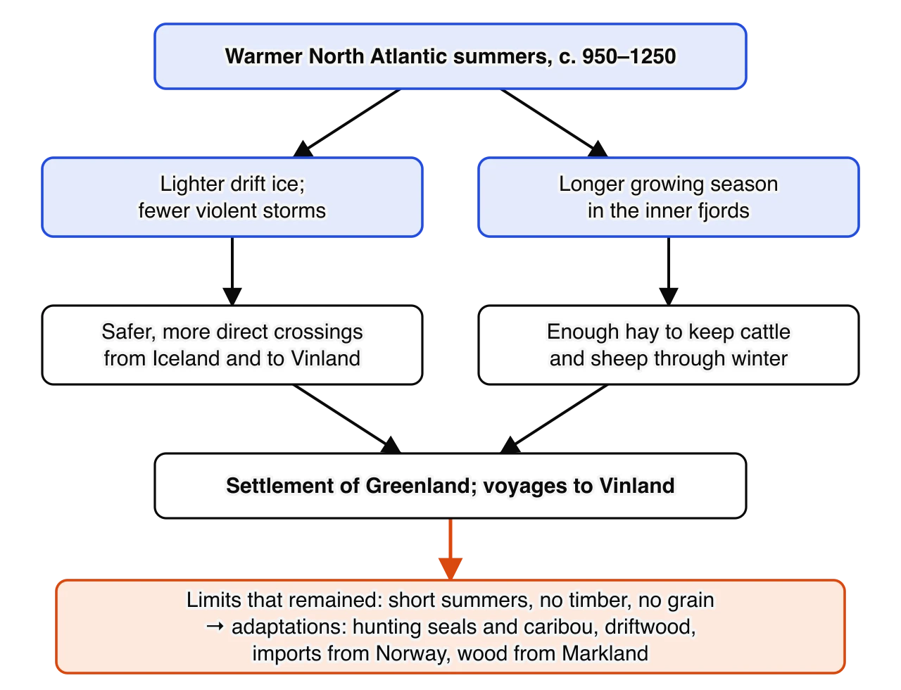
The diagram of climate effects shows the two paths by which the warmer period shaped Norse innovation: light sea ice made the crossings practical, and longer growing seasons made Greenland farming possible. It also shows the limits that remained. Greenland's short summers, lack of timber and failure to ripen grain forced the settlers to adapt, and these adaptations were among their most important innovations.
The Norse did not invent new tools or machines in Greenland and Vinland. Their innovations were of a different kind: they established communities in places no European had lived, reorganised the way they produced food to suit those places, and opened contact and trade with peoples they had never met. Each of these was an adaptation of familiar practices to unfamiliar conditions.
The settlers who arrived in about 985–986 founded two separate districts on the south-west coast. The larger, the Eastern Settlement (Eystribyggð), lay around Eiriksfjord and the neighbouring fjords near the southern tip of Greenland. The Western Settlement (Vestribyggð) lay about 400–500 kilometres further north by sea, in the fjords near modern Nuuk. Despite their names, both were on the west coast; "eastern" and "western" reflect the direction in which the coast runs. Between them were a few farms that some historians call a middle settlement.
Eastern Settlement | Western Settlement | |
|---|---|---|
Location | Fjords around modern Qassiarsuk, Narsaq and Igaliku, near Greenland's southern tip | Fjords inland from modern Nuuk, about 500 km to the north-west |
Farm sites found by archaeologists | About 190–500, depending on whether shielings and outbuildings are counted | About 95 |
Estimated population at its peak (twelfth–thirteenth centuries) | About 1,500–4,000 | About 500–1,000 |
Leading centres | Brattahlíð (Erik's farm); later Garðar, seat of the thing and, from about 1126, of a bishop | Sandnes, the largest farm |
End of the settlement | Last written record 1408 (a wedding at Hvalsey); abandoned by about 1450 | Abandoned by about 1360 |
Data: Jette Arneborg, "Greenland, the starting-point for the voyages to North America" (1993); Niels Lynnerup, The Greenland Norse (1998). Estimates vary widely because they are calculated from farm ruins and graves, not counted.
The settlement figures describe the colony at its height, long after 1020. In this period the colony was much smaller: perhaps a few hundred people on the fourteen ships that arrived in 985–986, joined by more settlers over the next generation. They chose sites at the heads of the fjords, where the best grass grew, and each family took a fjord or a stretch of shore, named after its first owner in the Icelandic way.
The settlers built farms of the kind they knew from Iceland. Houses had thick walls of turf and stone, which insulated well, and roofs of turf laid on a frame of driftwood. Each farm had a dwelling, byres for cattle, pens and barns, and stores; outlying summer huts (shielings) were used while animals grazed distant pastures. At Brattahlíð, building work in 1961 uncovered a tiny turf church, and excavations in the following years found a churchyard with about 140 burials. It is usually identified with the saga's account of the church that Erik's wife Thjodhild built after she became a Christian, and it is one of the earliest churches in the Americas.
Greenland copied Iceland's political system as well as its farms. It had no king, and its leading farmers met at their own thing, later held at Garðar. Greenland remained an independent commonwealth of farmers until 1261, when it accepted the rule of the Norwegian king. The colony was therefore an innovation in organisation as much as in geography: a self-governing community of a few thousand people at the edge of the known world, linked to Europe by a handful of ships a year.
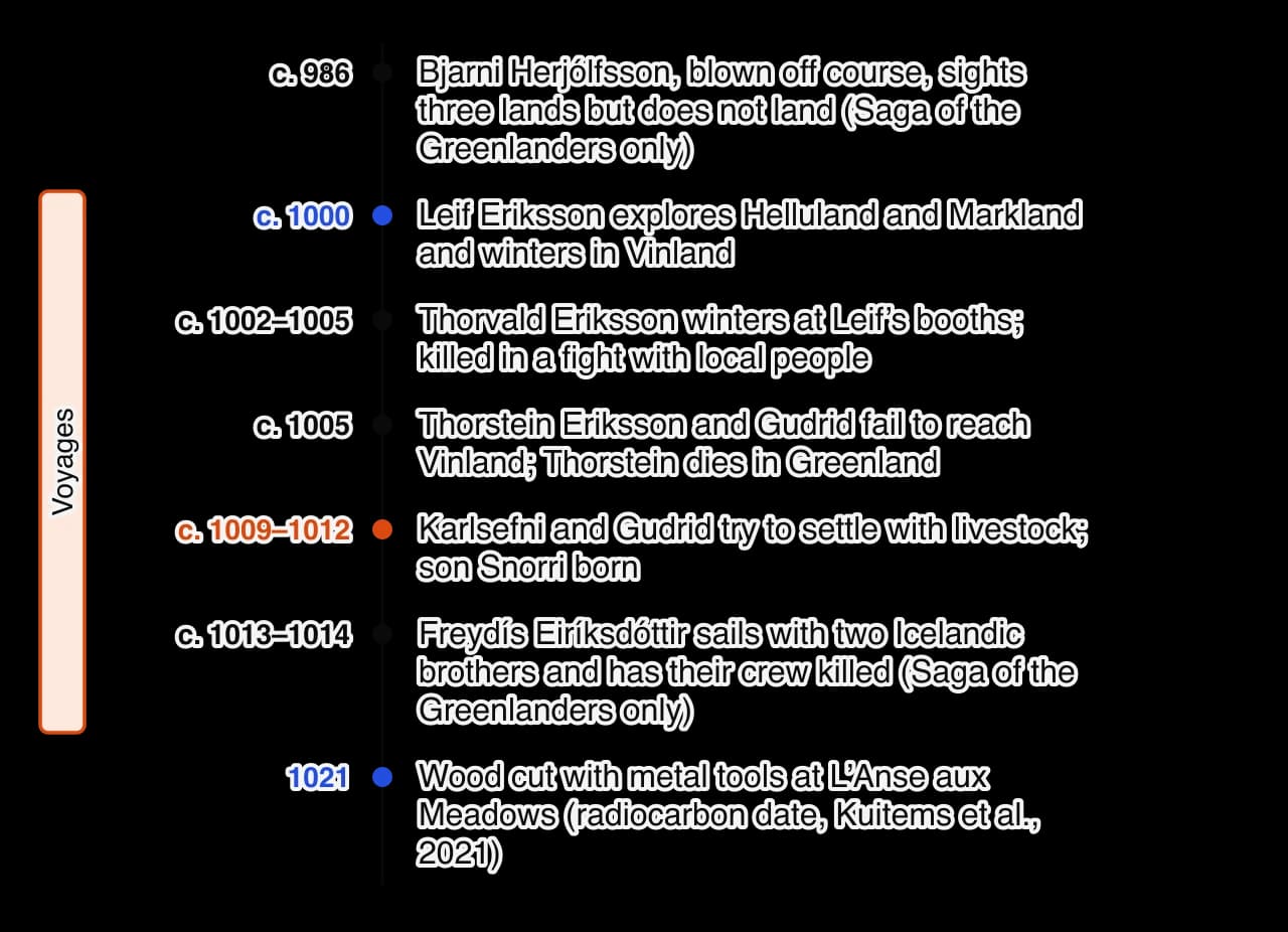
The vertical timeline of the Vinland voyages shows that, according to the Saga of the Greenlanders, there were at least five expeditions from Greenland in about fifteen years. Only one, led by the Icelandic merchant Thorfinn Karlsefni and his wife Gudrid Thorbjarnardóttir, was a serious attempt to found a colony. It took men, women and livestock, and its members stayed for two or three winters. Their son Snorri, born in Vinland in about 1010, is the first child of European descent known to have been born in the Americas.
For centuries historians argued about whether Vinland was real and where it was. Suggestions ranged from Labrador to Virginia. The question was settled in 1960, when the Norwegian explorer Helge Ingstad was shown a group of overgrown mounds at L'Anse aux Meadows, on the northern tip of Newfoundland, by a local resident, George Decker. Ingstad and his wife, the archaeologist Anne Stine Ingstad, led excavations there from 1961 to 1968, and Parks Canada excavated further in the 1970s. The site became a UNESCO World Heritage Site in 1978. Parks Canada describes what the first excavators found.
Inside the cooking pit of one of the large dwellings lay a bronze, ring-headed pin of the kind Norsemen used to fasten their cloaks. Inside another building was a stone oil lamp and a small spindle whorl, once used as the flywheel of a handheld spindle. […] From these finds we know not all the Norse settlers had been men.
Parks Canada, "Culture and history", L'Anse aux Meadows National Historic Site, website, accessed 2026. As the agency that manages the site and presents it to visitors, Parks Canada writes in plain language for the public and summarises the agreed archaeological interpretation. It is useful as a summary of the evidence, though not as a place to find debate about it.
The site contained eight buildings of turf over a wooden frame, built in the same style as houses in Iceland and Greenland around the year 1000. Three were large halls, each with smaller huts. A fourth complex, set apart, was a smithy where iron was produced from local bog iron in a small furnace, probably to make the iron rivets needed to repair ships; many iron rivets and much slag were found. The finds show that both men and women were present, that ships were repaired there and that the site was used for only a short time, perhaps a few years.
The Canadian archaeologist Birgitta Wallace, who led much of the later research, argues that L'Anse aux Meadows was not a farm or a colony but a base: a gateway camp where expeditions spent the winter, repaired their ships and stored goods gathered further south. It had no barns or byres, no sign of grazing and no bones of farm animals, only those of seals and whales. The butternuts show that people from the site travelled at least as far as the Gulf of St Lawrence. Wallace argues that the site is the Straumfjord of the Saga of Erik the Red, and others have linked it with Leif's booths in the Saga of the Greenlanders; she places the lagoon of Hóp in the Miramichi area of north-eastern New Brunswick. Other scholars accept the site as Norse but doubt these identifications, and no inscription or document proves them.
A scientific study published in 2021 gave the site its first exact date. Researchers led by Margot Kuitems examined three pieces of wood from the Norse layers that had been cut with metal tools, which the local Indigenous peoples did not make at the time. A sudden spike in radiocarbon caused by a cosmic-ray event in 993 is recorded in the tree ring for that year, and by counting the rings from the spike to the bark edge they found that all three trees had been cut in the same year.
Here we provide evidence that the Vikings were present in Newfoundland in ad 1021. We overcome the imprecision of previous age estimates by making use of the cosmic-ray-induced upsurge in atmospheric radiocarbon concentrations in ad 993. Our new date lays down a marker for European cognisance of the Americas, and represents the first known point at which humans encircled the globe.
Margot Kuitems et al., "Evidence for European presence in the Americas in AD 1021", Nature, 20 October 2021. The study is scientific and peer-reviewed, and its date is far more precise than anything in the sagas. It shows only that Norse people cut wood at the site in 1021, not how long they stayed or who they were; its claim about humans "encircling the globe" is an interpretation of significance added by the authors.
 YouTube
The two sagas that describe the voyages agree on the outline but differ in many details, which matters for any argument about who did what.
Saga of the Greenlanders (Grœnlendinga saga) | Saga of Erik the Red (Eiríks saga rauða) | |
|---|---|---|
Date of writing and manuscript | About 1200–1230; one copy, in Flateyjarbók (1387–1394) | About 1220–1280; two copies, in Hauksbók (early 1300s) and Skálholtsbók (early 1400s) |
First sighting of North America | Bjarni Herjólfsson, about 986 | Not mentioned; Leif finds Vinland by accident on his return from Norway |
Number of voyages | Five or six (Bjarni, Leif, Thorvald, Thorstein, Karlsefni, Freydís) | Essentially one large expedition led by Karlsefni, with Thorvald and Freydís taking part |
Central hero | Leif and the sons of Erik | Karlsefni and Gudrid, from whom several Icelandic bishops descended |
Place names | Leif's booths | Straumfjord (a base) and Hóp (a lagoon further south) |
Contact with skrælingjar | Trade in milk and dairy products for furs; an attack after a skræling is killed trying to take weapons | Trade in red cloth for furs; a large attack; Freydís frightens the attackers |
Many scholars think the Saga of Erik the Red was revised to give Gudrid and Karlsefni, ancestors of thirteenth-century bishops, the leading role, while the Saga of the Greenlanders preserves a simpler, older tradition centred on Erik's family. Neither can be taken at face value. Where they agree, for instance on Leif's naming of the lands, on a short-lived base and on trade followed by violence, the tradition is more likely to be reliable, and archaeology at L'Anse aux Meadows supports that core.
Vinland was never settled permanently. The sagas say that Karlsefni's group left after about three winters, and the archaeology of L'Anse aux Meadows points to a short period of use. Historians explain the failure through several connected factors.
Distance and numbers. Vinland lay well over 1,500 kilometres by sea from Brattahlíð. Greenland had only a few hundred people and few ocean-going ships, and could not send a steady flow of settlers and supplies.
Hostility of the Indigenous inhabitants. The sagas describe attacks that the Norse, with iron weapons but no firearms and few fighters, could not easily resist. In the Saga of Erik the Red the settlers conclude that, however good the land, they would always live in fear of its inhabitants.
Little need. Greenland in 1000–1020 still had unused land, so Vinland was not needed for farms. Its timber, grapes and furs could be collected on short voyages without a permanent colony.
Internal conflict. The sagas report quarrels among the settlers, culminating in the killings ordered by Freydís.
The archaeologist Thomas McGovern (1981) compared the Vinland attempt with later European colonies in North America, such as Jamestown and the early French settlements in Canada, which also suffered huge losses despite larger numbers and better supplies. He argues that the Norse lacked a military advantage over the Indigenous peoples, had too few ships and people, and depended on a small, poor home colony, so the colony's chances of success were never high. On this view the abandonment of Vinland was a rational decision more than a failure of nerve.
The settlers brought the farming system of Iceland with them: cattle, sheep, goats, a few pigs and horses, and the knowledge needed to keep them alive through a long northern winter. Grain grew poorly or not at all, so the economy rested on livestock and dairy products. Cattle produced milk, which was made into butter, cheese and skyr (a soured, strained milk product that could be stored), while sheep gave wool, milk and meat. These foods could be stored for the winter, when fresh food was scarce.
The key to the system was hay. In Greenland cattle had to be kept indoors in byres for up to seven months, tied in stalls and fed on hay cut in the short summer. Farmers enclosed the best land near the house as an infield, spread it with manure from the byres and, at some farms including Brattahlíð and Garðar, dug irrigation channels to water it. Animals were driven to outlying pastures and shielings in summer so that the home meadows could grow hay. Cattle were a sign of wealth and status, and the largest farms had byres for dozens of animals; poorer farms kept mainly sheep and goats, which needed less fodder.
A Norwegian text written in about 1250 describes the result as it was reported in Norway.
It is reported that the pasturage is good and that there are large and fine farms in Greenland. The farmers raise cattle and sheep in large numbers and make butter and cheese in great quantities. The people subsist chiefly on these foods and on beef; but they also eat the flesh of various kinds of game, such as reindeer, whales, seals, and bears.
Konungs skuggsjá (The King's Mirror), Norway, about 1250; translation by Laurence M. Larson (1917). The book is a dialogue in which a father teaches his son, written to educate young men for a career at court or in trade. Its author never visited Greenland and relied on reports from merchants and Greenlanders, so it shows how Greenland was understood in Norway more than two centuries after 1020. It is valuable for the balance between farming and hunting, but "large and fine farms" reflects the wealthiest households its informants knew.
From the start the settlers added the wild resources of Greenland to their farm produce. Each spring, when harp and hooded seals migrated along the outer coast, men from several farms joined together to hunt them, probably with nets and boats; the meat was eaten fresh or dried and stored. Inland they hunted caribou, sometimes driving herds towards hunters with lines of stones and cairns. They also took seabirds and their eggs. Few fish bones have been found at Norse farms, although fish were plentiful in the fjords.
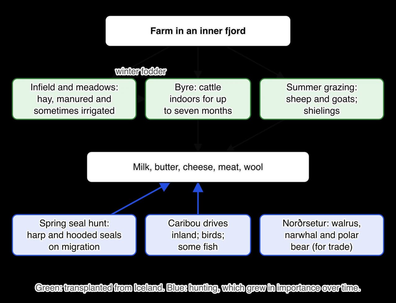
The diagram of the farm economy shows two systems working side by side. The livestock system came from Iceland; the hunting system was the new element, and it grew in importance. Scientists can measure how much food from the sea people ate by stable isotope analysis of the carbon and nitrogen preserved in their bones.
Period | Share of diet from marine foods (bone isotope evidence) | What it suggests |
|---|---|---|
Early eleventh century (first generations) | About 20–30 per cent | A farming diet supplemented by hunting, close to that of Iceland |
Fourteenth to early fifteenth century | About 50–80 per cent | Heavy reliance on seals as the climate cooled and farming became harder |
Data: Jette Arneborg, Niels Lynnerup and Jan Heinemeier, studies of Norse skeletons in the Journal of the North Atlantic, Special Volume 3 (2012).
The isotope results show adaptation, not failure to adapt. The first generation lived much as Icelanders did, but over the following centuries Greenlanders ate more and more seal meat. Most of this change came long after 1020; it is a long-term consequence of the hunting practices that began in the first decades of settlement.
In Vinland the Norse did not farm. The sagas describe the voyagers living off wild resources: salmon in the rivers, game in the forests, a stranded whale, wild grapes and "self-sown wheat" (probably lyme grass or wild rice). Karlsefni's expedition took cattle, and a bull frightened the skrælingjar, but there is no evidence of fields or byres at L'Anse aux Meadows. The bones found there are of seals and whales. What the Norse took from Vinland was raw material, above all timber, which Greenland lacked, and the voyages can be seen as resource-gathering expeditions more than attempts to found farms.
Skrælingjar (singular skræling) was the name the Norse gave to the Indigenous peoples they met in Greenland and North America. The original meaning of the word is uncertain; it may have meant something like "weaklings" or "people dressed in skins", and it was not a name these peoples used for themselves. It covered several quite different groups, and the Norse made no distinction between them.
When Erik's settlers arrived, south-west Greenland had no living inhabitants. Ari Thorgilsson records that the settlers found, in both the east and the west, the remains of human dwellings, fragments of skin boats and stone tools, and concluded that the same kind of people had lived there as those in Vinland whom the Greenlanders called skrælingjar. These remains probably belonged to earlier Arctic cultures such as the Dorset, who had lived in parts of Greenland. The ancestors of the modern Inuit, the Thule people, reached northern Greenland only in the thirteenth century, so there was little or no contact with Indigenous people in Greenland in the period 982–1020.
In Vinland the Norse met people who were much more numerous than themselves. They were probably the ancestors of the Beothuk of Newfoundland or the Innu of Labrador, and, further south, of the Mi'kmaq, who were hunters and fishers using skin or bark canoes. The Saga of Erik the Red describes the first trade with them at Karlsefni's camp.
Especially did the strangers wish to buy red cloth, for which they offered in exchange peltries and quite gray skins. They also desired to buy swords and spears, but Karlsefni and Snorri forbade this. In exchange for perfect unsullied skins, the Skrellings would take red stuff a span in length, which they would bind around their heads.
Eiríks saga rauða (Saga of Erik the Red), translation by Arthur Middleton Reeves (1890). The saga records the exchange from the Norse side only. It presents the trade as a bargain for the Norse, who cut the cloth into ever narrower strips while still receiving the same furs, and it shows that they refused to sell weapons. The Indigenous traders' own reasons, perhaps the value of red as a colour of ritual or prestige, are not recorded.
The Saga of the Greenlanders gives a different version: the Indigenous visitors wanted milk and dairy products, and "carried their wares away in their stomachs", leaving their furs behind. Both sagas agree that trade was in furs and skins on one side, and cloth or food on the other, and that the Norse would not trade metal weapons.
Contact did not stay peaceful. In the Saga of the Greenlanders, Leif's brother Thorvald and his men found nine men lying under three skin boats on a beach and killed eight of them; in a counter-attack Thorvald was mortally wounded by an arrow. At Karlsefni's camp, one of the visitors was killed while trying to take weapons, and a larger attack followed. In the Saga of Erik the Red, a bull frightened the traders away, and three weeks later a large force attacked the camp, killing two of Karlsefni's men. After this the Norse decided to leave.
The sagas show the Norse as willing to trade but quick to use violence, suspicious of people they could not understand, and outnumbered. They also show the Norse seizing two children in Markland and taking them back to Greenland to be baptised. From the Indigenous side the encounters probably looked like an intrusion by armed strangers, but no Indigenous account of them survives.
Trade with the skrælingjar in Vinland was brief and small in scale. It did not create a lasting exchange network, and the Norse did not bring back enough furs to make the voyages pay. Its significance lies in its being the first recorded exchange between Europeans and the peoples of the Americas, and it shows the pattern of later encounters in miniature: curiosity and trade, a refusal to share weapons, misunderstanding and then violence.
Trade of a different kind became the basis of Greenland's economy. Walrus ivory, walrus-hide rope, narwhal tusks, polar bear skins and live falcons from the Arctic were luxury goods in Europe, and they paid for the iron, timber, grain and church goods that Greenland could not produce.
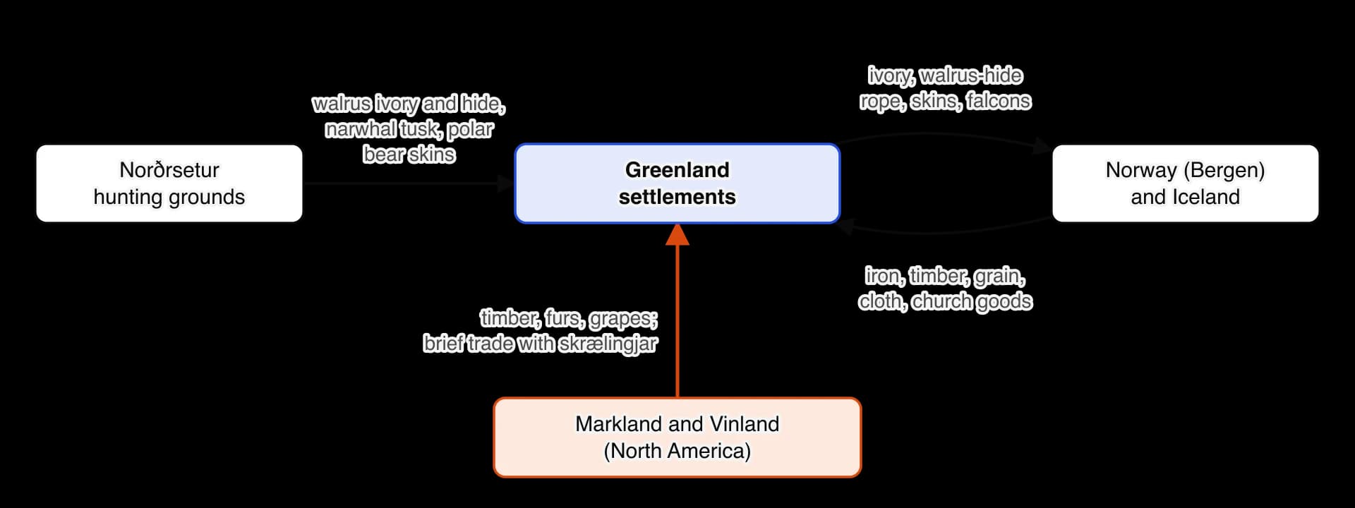
The diagram of Greenland's trade shows how the colony paid its way. The walrus-ivory trade grew mainly in the eleventh to thirteenth centuries, largely after 1020, and ancient DNA from ivory objects found across Europe confirms that much of it came from Greenland. Contact with North America did not end in 1020 either: Icelandic annals record that in 1347 a small Greenland ship that had sailed to Markland, probably for timber, was driven off course to Iceland.
Europeans outside Scandinavia heard about Vinland within a lifetime of the voyages. The German churchman Adam of Bremen, writing in about 1075, reported what the Danish king had told him.
Moreover he spoke of an island in that ocean discovered by many, which is called Vinland, for the reason that vines grow wild there, which yield the best of wine. Moreover that grain unsown grows there abundantly, is not a fabulous fancy, but, from the accounts of the Danes, we know to be a fact.
Adam of Bremen, Descriptio insularum Aquilonis (Description of the Northern Islands), part of his history of the archbishops of Hamburg-Bremen, about 1075; translation in Olson and Bourne (1906). This is the earliest surviving written mention of Vinland, written about sixty years after the voyages and a century and a half before the sagas. Adam had never been to the North Atlantic and depended on King Svein Estridsen of Denmark, so the passage proves that Vinland was known of in Scandinavia, not what the Norse did there.
No one who sailed to Greenland or Vinland left a written account. The Norse of the period used runes for short inscriptions, but they did not write histories. Everything historians know comes from texts written long afterwards, from archaeology and from the natural sciences, and each kind of evidence answers different questions.
Type of source | Examples | What it can show | Main limitations |
|---|---|---|---|
Early Icelandic history | Ari Thorgilsson, Íslendingabók (c. 1122–1133); Landnámabók (12th–13th centuries) | Dates, names, numbers of ships, the naming of Greenland | Written 100–250 years later; brief; interested in genealogy and land rights |
Sagas | Saga of the Greenlanders (c. 1200–1230); Saga of Erik the Red (13th century) | The voyages, people, encounters and motives as Icelanders remembered them | Written over 200 years later from oral tradition; disagree with each other; shaped by family pride and Christian values |
Foreign chronicle | Adam of Bremen (c. 1075) | That Vinland was known of in Scandinavia within about 60 years | Second-hand; Adam never visited the North Atlantic |
Didactic writing | The King's Mirror (Norway, c. 1250) | How Greenland's economy and attractions were understood in Norway | Two centuries later; based on reports, not observation |
Archaeology | Brattahlíð, the Narsaq farm, L'Anse aux Meadows, the Skuldelev ships | Houses, farms, diets, technology, the presence of women, dates | Cannot show motives or names; interpretation of sites can change |
Natural science | Ice cores, tree rings, isotope studies, radiocarbon dating | Climate, diet and exact dates | Shows conditions and processes, not decisions; proxies may not match local conditions |
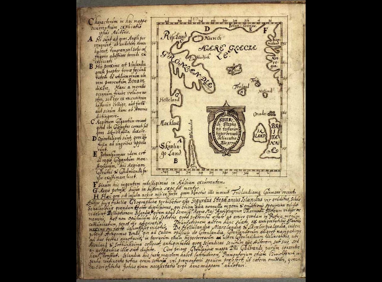
Maps | The Skálholt map (c. 1570–1590) | How later Icelanders imagined the lands in the sagas | Made nearly six centuries later from the sagas, not from exploration |
The table of source types shows that the written and the material evidence complement each other. The sagas give names, motives and stories but are late and partisan; archaeology and science give hard evidence of where people lived, what they ate and when, but are silent on why. The strongest conclusions are those that several kinds of evidence support at once, such as the existence of a short-lived Norse base in Newfoundland around 1021.
Historians, archaeologists and climate scientists have interpreted Norse exploration in different ways, and the interpretations have changed as new evidence has appeared. Four debates matter most.
Older accounts, such as Gwyn Jones's The Norse Atlantic Saga (1964), read the sagas as broadly reliable narratives and stressed the energy and daring of leaders such as Erik and Leif. Later scholars put more weight on structural pressures: the shortage of farmland, the demands of a chiefly society that rewarded men who could grant land to followers, and the desire for goods that the home country lacked. Archaeologists such as Birgitta Wallace and Thomas McGovern have argued that the Vinland voyages were driven mainly by Greenland's need for timber and other resources, not by land hunger, since Greenland itself still had land to spare.
These views can be combined. Land shortage in Iceland explains the readiness of hundreds of people to follow Erik to Greenland; the search for resources explains the Vinland voyages; the ambition of individual chieftains explains the timing and organisation of both.
Hubert Lamb's work in the 1960s encouraged a strongly environmental explanation, in which a warm period opened the North Atlantic and a later cooling closed it. Since then, climate reconstructions such as those of Mann and colleagues (2009) have shown that the medieval warmth was regional and uneven, and historians have become more cautious about environmental determinism. Most now treat climate as a condition that made the voyages and Greenland farming possible, while human choices determined what was done with that opportunity.
The significance of Vinland has been judged very differently over time. In the nineteenth century, Scandinavian immigrants in the United States promoted Leif Eriksson as the true discoverer of America, partly to claim a respected place in American history; in 1964 Congress authorised the president to proclaim 9 October each year as Leif Erikson Day. Sceptics long doubted that the sagas described real places. The Ingstads' excavations from 1961 ended that debate, and the dating of 2021 gave the Norse presence an exact year.
Some historians stress the voyages' significance as the first known contact between Europeans and the peoples of the Americas, and, as Kuitems and her colleagues put it, the first time humans encircled the globe. Others point out that the voyages had no lasting consequences: no permanent settlement, no known exchange of crops or diseases, and no influence on the later voyages of Columbus. The significance of the voyages also depends on perspective. For Indigenous peoples, whose ancestors had lived in the Americas for thousands of years, the idea of "discovery" is misleading, and the first contact is significant mainly as a brief, often violent encounter that their own traditions do not clearly record.
Although the end of Norse Greenland lies far beyond 1020, the debate about it shapes how historians judge the innovations of the first settlers. In Collapse (2005), the geographer Jared Diamond argued that the Greenland Norse died out because they clung to a European, cattle-farming and Christian identity, damaged their fragile environment, and refused to learn from the Inuit, for example by not eating fish. Later research has challenged much of this. Isotope studies by Jette Arneborg and colleagues (2012) show that the Norse ate large and growing amounts of seal meat, and archaeologists such as Andrew Dugmore, Christian Keller and Thomas McGovern (2007) explain the end of the settlements by a combination of colder weather, the falling value of walrus ivory in Europe, isolation and emigration, not by a simple refusal to adapt.
Historian or scientist | Work | Argument | Evidence stressed |
|---|---|---|---|
Hubert Lamb | "The early medieval warm epoch and its sequel" (1965) | A warm epoch c. 1000–1200 shaped life in the North Atlantic | Written records of harvests, vineyards and ice; early climate data |
Michael Mann and colleagues | Science (2009) | The "Medieval Climate Anomaly" was regional, not a single global warm period | A global network of proxy records |
Helge and Anne Stine Ingstad | Excavations at L'Anse aux Meadows (1961–1968) | The Norse reached Newfoundland; the sagas preserve real events | Norse-style buildings, iron working, a bronze pin and a spindle whorl |
Birgitta Wallace | "The Norse in Newfoundland" (2003) | L'Anse aux Meadows was a short-lived gateway base, not a colony; Vinland stretched further south | No barns or livestock; butternuts from the south; specialised buildings |
Thomas McGovern | "The Vinland Adventure" (1981) | Vinland's chances of success were always low | Comparison with later European colonies; Greenland's small population and few ships |
Jared Diamond | Collapse (2005) | Greenland failed through cultural conservatism and environmental damage | Few fish bones; cattle farming; church building |
Jette Arneborg and colleagues | Journal of the North Atlantic (2012) | The Greenlanders adapted flexibly to their environment | Bone isotopes showing a rising marine diet |
Margot Kuitems and colleagues | Nature (2021) | The Norse were at L'Anse aux Meadows in 1021 | Radiocarbon in tree rings, using the cosmic-ray event of 993 |
The table of interpretations shows a broad shift. Earlier work tended either to trust the sagas as stories of heroic leaders or to explain events through climate. More recent work, based on archaeology and science, presents the Norse as practical people who adapted to difficult environments, made rational choices about where to settle and when to leave, and were limited by their small numbers and their distance from Europe.
Sources on this study raise particular problems of date and perspective, which the second and third questions reward.
Focused study 1: Climate and innovation. Norse exploration (circa 982–1020). A set written in the style of the IB. Using the three provided sources on Norse exploration and considering the overarching inquiry question of "To what extent was a shortage of farmland the main reason for Norse voyages westward between c. 982 and 1020?", respond to the following three questions.
Source A: Eiríks saga rauða (Saga of Erik the Red), an anonymous Icelandic saga written in the thirteenth century from oral tradition, translated by Arthur Middleton Reeves in The Finding of Wineland the Good (1890).
Eric and his people were condemned to outlawry at Thorsness-thing. He equipped his ship for a voyage, in Ericsvag […] He said to them, that it was his intention to go in search of that land which Gunnbiorn, son of Ulf the Crow, saw when he was driven out of his course, westward across the main […] He told them that he would return again to his friends, if he should succeed in finding that country. […] That summer Eric set out to colonize the land which he had discovered, and which he called Greenland, because, he said, men would be the more readily persuaded thither if the land had a good name.
Source B: Birgitta Wallace, a Canadian archaeologist who worked for Parks Canada on the excavation of L'Anse aux Meadows, in the journal article "The Norse in Newfoundland: L'Anse aux Meadows and Vinland", Newfoundland Studies (2003).
Its situation on the most exposed bay in the area contrasts with the sheltered areas favoured for West Norse livestock farming. The usual large West Norse barns and byres are missing. Specific archaeological testing showed no sign of enclosures or shelters for livestock of any kind, or of disturbances in the flora caused by grazing and cultivation. […] At L'Anse aux Meadows, however, there was no attempt to establish a self-supporting colony, capable of producing its own sustenance. Instead, both the architectural layout and artifact distribution suggest that this was a highly specialized, non-farming settlement.
Source C: Konungs skuggsjá (The King's Mirror), a book of instruction written by an unknown Norwegian, probably a member of the royal court, in about 1250, in the form of a dialogue between a father and his son; translated by Laurence M. Larson (1917). The son has asked why men travel to Greenland.
The answer to your query as to what people go to seek in that country and why they fare thither through such great perils is to be sought in man's threefold nature. One motive is fame and rivalry, for it is in the nature of man to seek places where great dangers may be met, and thus to win fame. A second motive is curiosity […] The third is desire for gain; for men seek wealth wherever they have heard that gain is to be gotten, though, on the other hand, there may be great dangers too. But in Greenland it is this way […] that whatever comes from other lands is high in price.
The three questions follow, each with markscheme guidance in the style of the IB's published approach.
Question 2 turns from content to context, and concerns source C only.
Question 3 brings all three sources together and carries the most marks.
This task uses the extract from Adam of Bremen's Description of the Northern Islands (about 1075) that describes Vinland as an island where vines grow wild and grain grows unsown. Inquiry question: "To what extent did the Norse voyages make North America known in Europe before 1100?"
This task uses two sources quoted in the teaching sections: the Saga of the Greenlanders' description of the place where Leif wintered (salmon, no frost, cattle needing no fodder) and the abstract of Kuitems and colleagues (2021) dating the Norse presence in Newfoundland to 1021. Inquiry question: "To what extent can the Vinland sagas be trusted as evidence of Norse activity in North America?"
I can explain who the Norse were and describe Norse society: bændr, chieftains, thralls, the thing, outlawry and gift exchange.
I can outline the settlement of Iceland and explain why its good land was taken by about 930.
I can explain how pressure on farmland in Norway and Iceland pushed people to emigrate, and how far it explains the Greenland and Vinland voyages.
I can describe clinker construction, the keel and the sail, and compare the longship with the knarr, using the Skuldelev ships as evidence.
I can explain how the Norse navigated without a compass and why the sun compass and sunstone are debated.
I can judge whether ship technology caused or only enabled Norse exploration.
I can explain the roles of Erik the Red and Leif Eriksson and weigh their importance against other factors.
I can explain what the Medieval Warm Period (Medieval Climate Anomaly) was, how it is reconstructed from proxy data, what may have caused it and why it is controversial.
I can describe the sea ice and environments of Greenland and Vinland and explain how they shaped Norse voyages and farming.
I can describe the Eastern and Western Settlements and how the settlers organised them.
I can explain what was found at L'Anse aux Meadows, how it was dated to 1021, and why historians see it as a base rather than a colony.
I can compare the Saga of the Greenlanders and the Saga of Erik the Red and explain why they differ.
I can explain why Vinland was abandoned.
I can describe the Greenland farming system and the shift towards hunting, using isotope evidence.
I can explain who the skrælingjar were, describe trade and conflict with them, and recognise the absence of Indigenous sources.
I can explain how Greenland's trade in Arctic goods developed from the settlements.
I can evaluate the context and perspective of the main sources: Íslendingabók, Landnámabók, the sagas, Adam of Bremen, The King's Mirror, archaeology and climate science.
I can explain the main historians' perspectives on why the Norse sailed west, the role of climate, the significance of Vinland and the adaptability of the Greenland Norse.