
Explain how waves, tides, sediment cells, rock type and subaerial processes shape coasts, how erosional and depositional landforms and dunes form, and how sea-level change creates emergent and submergent coasts.
Each is in the Geography glossary, with every other term in the subject.
The return flow of water down a beach under gravity after the swash, carrying sediment back towards the sea at right angles to the shoreline.
A ridge of sand or shingle that extends across a bay, joining two headlands and enclosing a lagoon behind it.
An accumulation of sand or shingle on the shore between the low water mark and the limit of storm waves, shaped by the balance between swash and backwash.
A hollow in a sand dune scooped out by wind erosion where the protective vegetation cover has been broken by trampling, grazing or storms.
A coastline where bands of rock of different resistance run parallel to the shore, so that a resistant outer band protects weaker rock behind it.
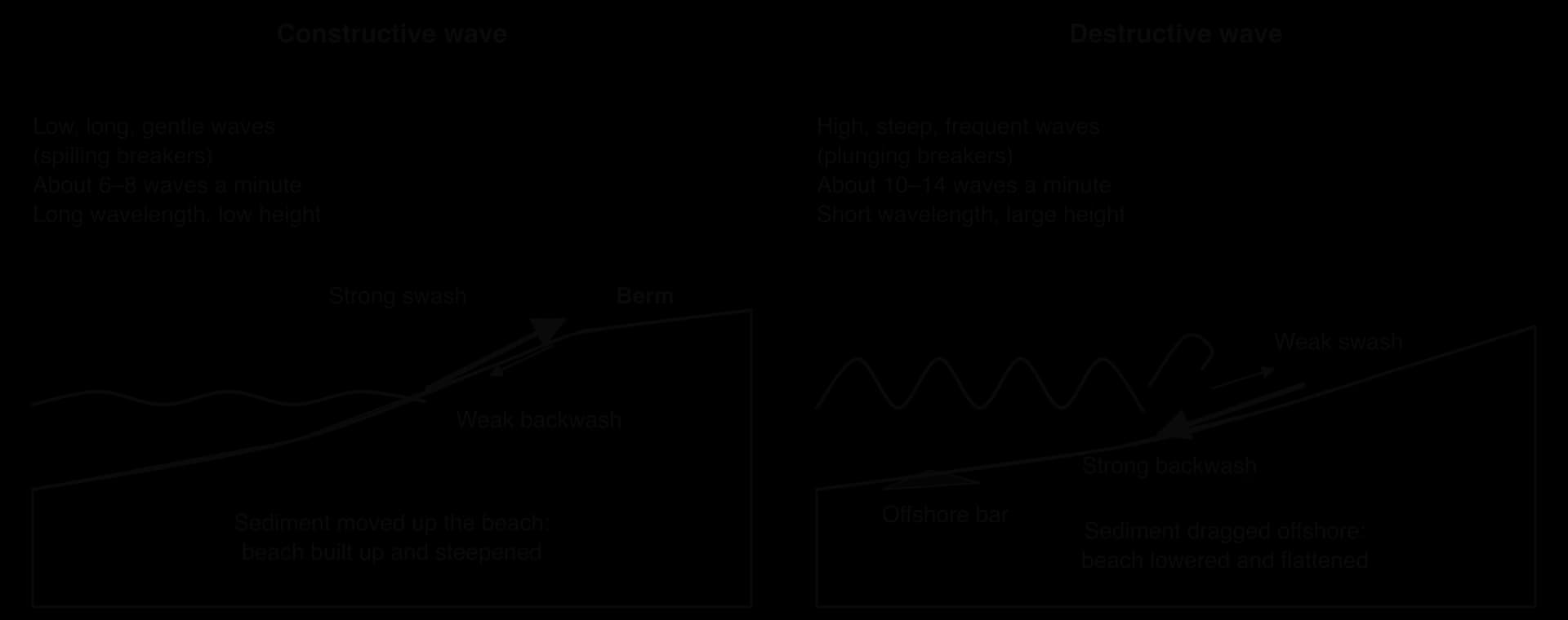
A low, long and gentle wave, breaking about 6–8 times a minute, whose strong swash and weak backwash move sediment up the beach and build it up.
A high, steep and frequent wave, breaking about 10–14 times a minute, whose strong backwash removes sediment from the beach and carries it offshore.
Explain how waves form and break, and distinguish between constructive and destructive waves.
Explain how wave refraction, tides, sediment supply, lithology, vegetation and subaerial processes influence coastal landscapes.
Explain the wave processes of hydraulic action, abrasion and longshore drift, and how sediment cells link places along a coast.
Describe and explain the formation of cliffs, wave-cut platforms, caves, arches, stacks and stumps.
Describe and explain the formation of beaches, spits, bars and tombolos.
Distinguish between eustatic and isostatic change and explain how they produce advancing and retreating coastlines.
Explain the formation of raised beaches, relict cliffs, fjords and rias.
Explain the role of coastal processes, wind and vegetation in sand dune development.
Analyse coastal data, such as erosion rates, tide-gauge records and dune transects, and examine the processes and landforms of one coastline.
The coast is the zone where land, sea and air meet, and where the energy of waves, tides and wind is spent against rock and sediment. Coastal landscapes change faster than almost any other: on the Holderness coast of England the cliffs retreat by one to two metres in an average year, and in places by several metres in a single stormy winter.
The topic is about process and place. The same waves produce cliffs and stacks where the rock is resistant, beaches and spits where sediment is plentiful, and very different coastlines where the land is rising or sinking. Because sediment moves along the coast, what happens in one place affects others downdrift, a
66 exam-style questions on this subtopic, written in the style of the IB papers. The first has its markscheme open. Counted on
Evaluate hard and soft engineering strategies for managing coastal erosion.
10 marks
Marks should be allocated according to the markbands.
Hard engineering uses artificial structures to resist or redirect wave energy and hold the coastline in place (sea walls, groynes, revetments, rock armour or rip-rap, gabions, offshore breakwaters). Soft engineering works with natural processes to absorb wave energy and allow some coastal change (beach nourishment, dune regeneration, salt-marsh creation, managed realignment). To evaluate, candidates should weigh the strengths and limitations of both approaches, for example in terms of effectiveness, cost, lifespan, environmental impact and side effects along the coast. Accept cliff stabilization measures under either heading if justified.
Possible applied themes (AO2) demonstrating knowledge and understanding (AO1):
Hard engineering gives high and immediate protection to high-value land: recurved sea walls reflect wave energy and can protect town centres and infrastructure for decades (eg the sea walls of many UK resorts such as Scarborough or Blackpool).
Hard structures are expensive to build and maintain (sea walls typically cost several thousand pounds per metre), and reflected waves can scour the beach in front, lowering it and undermining the structure.
Groynes trap longshore drift and build up the beach locally but starve down-drift areas of sediment, eg at Mappleton on the Holderness coast, where two rock groynes and a revetment (1991, about £2 million) protected the village while erosion increased to the south towards Cowden.
Soft engineering is generally cheaper per metre and more visually acceptable, but often needs repeating: beach nourishment must be topped up as sand is lost (eg Miami Beach and many Dutch beaches are renourished regularly).
Large-scale soft approaches can last longer than expected: the Sand Motor (Zandmotor) in South Holland, Netherlands (2011, about 21.5 million m³ of sand, about €70 million) lets waves and currents spread sand along the coast over many years, a "building with nature" approach.
With a free account, Augment remembers where you stopped and what you have practiced.
A coastline where bands of rock of different resistance run at right angles to the shore, so that weak rock is eroded into bays and resistant rock forms headlands.
A damp hollow between dune ridges where the surface lies close to the water table, supporting moisture-loving plants such as reeds, rushes and willows.
A small, young and unstable sand dune at the top of a beach, formed where sand collects around obstacles and is colonised by salt-tolerant pioneer plants such as sea couch grass.
A coastline where the land has risen relative to the sea, leaving former shoreline landforms such as raised beaches and relict cliffs above the reach of waves.
A worldwide change in sea level caused by a change in the volume of ocean water, such as water stored in ice sheets during glacial periods or melting and thermal expansion today.
The distance of open water over which the wind blows to generate waves; the longer the fetch, the larger and more powerful the waves can become.
A long, narrow, deep and steep-sided coastal inlet formed when a glacial trough was flooded by the sea, often with a shallow rock threshold at its mouth.
A young, mobile sand dune behind the embryo dunes, dominated by marram grass, with bare sand between the plants giving it a yellow colour; also called a yellow dune.
The slow rise of the Earth’s crust after the melting of an ice sheet that had pressed it down, continuing for thousands of years.
A more stable sand dune further inland, darkened by humus and colonised by mosses, lichens and other plants, with more acidic soil than younger dunes.
A change in the level of the land relative to the sea, caused by the crust rising or sinking, for example under the weight of an ice sheet or after it melts.
The physical and chemical characteristics of a rock, such as mineral composition, hardness, grain size and permeability, which affect its resistance to erosion and weathering.
The movement of sediment along a coast by waves approaching at an angle, as swash carries material diagonally up the beach and backwash returns it straight down; also called littoral drift.
A coarse grass adapted to coastal dunes, with rolled leaves that reduce water loss, deep roots and rapid growth when buried by sand, which binds and builds foredunes.
A tide with the smallest tidal range, occurring twice a month when the Sun and Moon are at right angles to each other relative to the Earth.
A plant succession that develops on bare sand, as on coastal dunes, from salt-tolerant pioneer plants near the beach to heath or woodland inland.
A former beach, now above present high tide level, left behind when the land rose relative to the sea; usually a flat terrace backed by a relict cliff.
The change in the level of the sea compared with the land at a particular place, the combined result of eustatic and isostatic change.
A former sea cliff no longer reached by the waves, because the land has risen or the coast has advanced, and now shaped by subaerial processes.
A drowned river valley formed when a rise in sea level flooded an unglaciated valley, becoming wider and deeper towards the sea.
An area of mudflats colonised by salt-tolerant plants in a sheltered, low-energy intertidal zone, such as behind a spit or in an estuary, where fine sediment settles.
A mound or ridge of sand deposited by the wind; coastal dunes form behind wide beaches where onshore winds carry dry sand inland and vegetation traps it.
A length of coastline, usually bounded by headlands or estuaries, within which sediment moves in a largely closed system of sources, transfers and sinks.
A long, narrow ridge of sand or shingle joined to the land at one end and extending across a bay or estuary, built by longshore drift where the coast changes direction.
A tide with the largest tidal range, occurring twice a month when the Sun, Moon and Earth are in line and their gravitational pulls combine.
An isolated pillar of rock standing in the sea off a headland, left when the roof of an arch collapses.
Processes that act on the land surface above the reach of waves, mainly weathering and mass movement, which weaken cliffs and move material down them.
A coastline where the sea has risen relative to the land, drowning former valleys to form features such as rias and fjords.
The gradual change in the plant communities of an area over time, as each stage alters conditions so that new species can establish, ending in a stable climax community.
The rush of water up a beach after a wave breaks, carrying sediment in the direction in which the wave is travelling.
The vertical difference in height between high tide and low tide at a place, from under 2 m on microtidal coasts to over 4 m on macrotidal coasts.
The periodic rise and fall of sea level, usually twice a day, caused by the gravitational pull of the Moon and the Sun on the Earth’s oceans.
A ridge of sand or shingle, formed by deposition, that joins an island to the mainland or to another island.
The bending of wave crests as they slow in shallow water near the coast, which concentrates wave energy on headlands and spreads it out in bays.
An indentation cut into the base of a cliff between high and low tide by hydraulic action and abrasion.
A gently sloping rocky surface at the base of a cliff, exposed at low tide, left behind as the cliff retreats through erosion and collapse.
The breakdown or decay of rock in its original place by physical, chemical or biological processes, without the rock being moved.
Waves are the main source of energy at the coast. Most are generated by wind blowing over the sea surface: friction between the moving air and the water transfers energy to the water and raises ripples that grow into waves.
The height and energy of a wave depend on three factors: the speed of the wind, the length of time it blows, and the fetch, the distance of open water over which it blows. The longer the fetch, the more energy the wind can transfer. Coasts facing a long fetch therefore receive powerful waves: Cornwall in south-west England faces several thousand kilometres of open Atlantic, while the Holderness coast is exposed to waves generated across the North Sea from the north-east.
Waves that travel far from the storm that created them become long, regular swell; waves still under the influence of local winds are called sea and are shorter and more irregular.
Wave energy increases with the square of wave height, so a wave twice as high carries about four times as much energy. This is why storm waves do most of the erosion on a coast, even though they occur on only a few days each year.
In deep water, a wave moves energy forward but not the water itself. Each water particle moves in a roughly circular orbit, returning almost to where it started as the wave passes; the orbits shrink with depth and die out at the wave base, at a depth of about half the wavelength. When the water becomes shallower than the wave base, the orbits touch the sea bed. Friction slows the base of the wave, the orbits become flattened ellipses, the wavelength shortens and the wave grows taller and steeper until the crest topples forward and the wave breaks.
After breaking, water rushes up the beach as the swash and drains back down as the backwash. The balance between the two decides whether a wave adds sediment to a beach or removes it. Waves break in three main ways: spilling breakers, on gently sloping beaches, collapse gradually; plunging breakers curl over and crash down; and surging breakers, on steep beaches, slide up the beach without fully breaking.
Whether swash or backwash is stronger depends on the wave and on how easily water drains into the beach.
Waves are classified by their effect on beaches. Constructive waves build beaches up; destructive waves comb them down. The same beach usually experiences both, constructive waves in calm summer weather and destructive waves in winter storms.
Characteristic | Constructive wave | Destructive wave |
|---|---|---|
Height | Low (usually under 1 m) | High |
Wavelength | Long | Short |
Frequency | About 6–8 per minute | About 10–14 per minute |
Steepness and breaker type | Gentle; spilling or surging | Steep; plunging |
Swash and backwash | Strong swash, weak backwash (water percolates into the beach) | Weak swash, strong backwash |
Effect on the beach | Sediment carried up the beach; a berm forms; profile steepens | Sediment dragged offshore, often into a bar; profile lowered and flattened |
Typical season | Summer, calm weather | Winter, storms |
Wave refraction is the bending of wave crests as they approach an irregular coastline. Off a headland the water is shallower, so the waves slow down there first, while the parts of the crests still in the deeper water of the bays move faster. The crests bend to become roughly parallel to the shore. As a result, wave energy converges on headlands, concentrating erosion there, and diverges in bays, where waves are lower and sediment is deposited to form beaches.

Refraction explains why an irregular coast tends to become straighter over time: headlands are worn back while bays fill with sediment. It also explains why beaches in bays face the dominant direction of wave approach.
A tide is the regular rise and fall of sea level caused by the gravitational pull of the Moon and, to a lesser extent, the Sun on the oceans, combined with the Earth’s rotation. Most coasts have two high tides and two low tides a day, about 12 hours 25 minutes apart.
The tidal range is the difference in height between high and low tide. It varies through the month. Spring tides occur when the Sun, Moon and Earth are in line, at new and full moon, so their pulls combine to give the highest high tides and lowest low tides. Neap tides occur when the Sun and Moon are at right angles to each other, at the first and last quarters of the Moon, so their pulls partly cancel and the range is smallest.
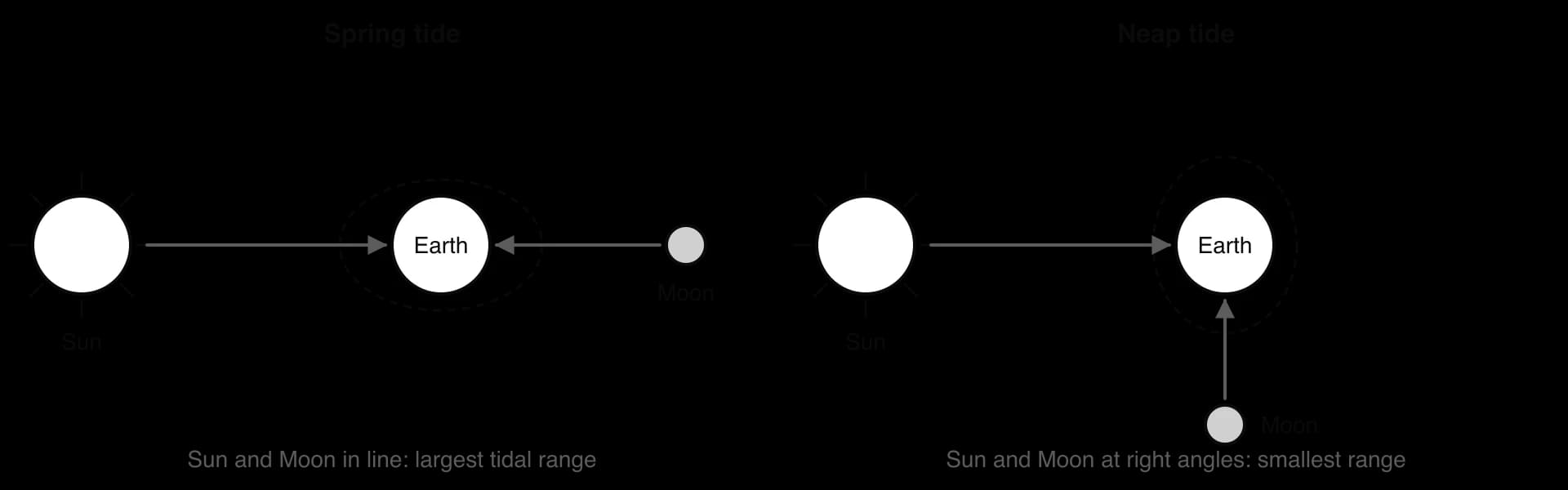
Tidal range also varies greatly from place to place, depending on the shape of the coast and the sea floor. Coasts are classed as microtidal (under 2 m), mesotidal (2–4 m) or macrotidal (over 4 m). The Mediterranean is mostly microtidal, with a range generally under 1 m, while the funnel-shaped Bay of Fundy in Canada has the largest tidal range in the world, about 16 m, because the shape of the bay makes the water resonate.
Tidal range matters because it sets the vertical band within which waves work. On a microtidal coast, wave energy is concentrated in a narrow zone, so erosion cuts sharp notches. On a macrotidal coast, waves attack a wide band of the shore, so wave-cut platforms can be very wide, and the large area of sand exposed at low tide can dry and be blown inland to form dunes. Strong tidal currents also move sediment, especially in estuaries.
Sources: Wikipedia, “Bay of Fundy” and “Tide” (accessed 2026).
Coastal landforms are built from sediment: mud, sand, shingle (pebbles) and boulders. The amount and type of sediment available decide whether a coast has wide beaches, dunes and spits or bare rock.
Rivers supply most of the sediment reaching the world’s coasts, carrying it to the sea in their load.
Cliff erosion supplies material locally, especially where cliffs are made of soft rock or glacial deposits, as in Holderness.
Offshore sources: waves and currents carry sand onshore from the sea bed, much of it left by rivers and glaciers when sea level was lower.
Longshore drift brings sediment from updrift parts of the coast.
Biogenic sources: shells and coral fragments, which make up most of the sand on many tropical beaches.
Sediment is moved along and across the coast (transfers) and stored for a time in beaches, spits, dunes, offshore bars, saltmarshes and estuaries (sinks). The difference between the sediment entering and leaving a stretch of coast is its sediment budget. A positive budget means the coast builds out; a negative one means it erodes.
A sediment cell (littoral cell) is a stretch of coast within which sediment moves in a largely closed system, with its own sources, transfers and sinks, and with little exchange with neighbouring cells. Cell boundaries are usually large headlands or deep estuaries that sediment cannot cross. The coastline of England and Wales is divided into 11 major cells, which are used as the units for shoreline management plans.
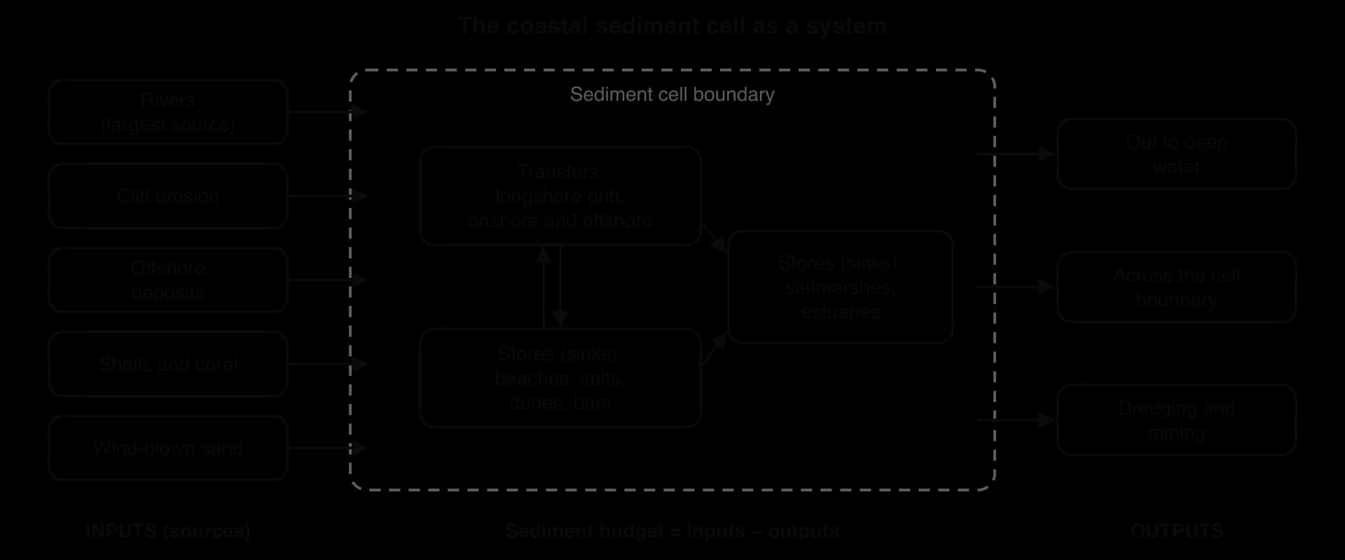
Because a cell is a connected system, a change in one part affects the rest. If cliffs are protected in one place, the supply of sediment to beaches further along the coast falls, and those beaches shrink and the cliffs behind them erode faster. On the Holderness coast, erosion has been measured at about 0.5 m a year north of the sea defences at Hornsea and about 2 m a year to the south, because the defences stop the sediment that would otherwise feed the beaches downdrift. How such effects are managed is a question for coastal management; for coastal landscapes, what matters is the spatial interaction that the sediment cell creates.
Sources: Wikipedia, “Hornsea”, citing East Riding of Yorkshire Council (2008) (accessed 2026).
Lithology is the physical and chemical character of a rock: its mineral composition, hardness, grain size and permeability. Resistant rocks such as granite, basalt and hard limestone erode slowly and form high, steep cliffs and headlands; weak rocks such as clay, shale and unconsolidated glacial till erode quickly and form low, slumping cliffs and bays. On Holderness, cliffs of glacial till retreat by about 1.5 m a year on average, among the fastest rates in Europe, while granite cliffs in Cornwall change little in a human lifetime.
Rock structure matters as much as rock type. Joints, faults and bedding planes are lines of weakness that waves exploit, and the dip of the strata shapes cliff profiles: beds dipping towards the sea give sloping cliffs prone to sliding, while horizontal or landward-dipping beds give steep, stable faces. The arrangement of rock bands in relation to the coastline produces two kinds of coast.
A concordant coast has bands of rock running parallel to the coastline. An outer band of resistant rock protects weaker rock behind it, so the coast stays straight until the sea breaks through, then erodes the weak rock behind into a rounded cove. Lulworth Cove in Dorset, where the sea has cut through Portland limestone into clays and sands, is the classic example; the Dalmatian coast of Croatia, with long islands parallel to the shore, is another.
A discordant coast has bands of rock at right angles to the coastline. The sea erodes the weak bands into bays and leaves the resistant bands as headlands, as on the Isle of Purbeck in Dorset, where the chalk headland of Ballard Down and the limestone of Durlston Head enclose Swanage Bay, cut in softer clays and sands.

Over time, a concordant coast can become discordant once the sea breaks through its outer band.
Plants slow coastal change by trapping and binding sediment. Marram grass traps wind-blown sand and binds dunes with its roots; saltmarsh plants such as cord-grass (Spartina) slow tidal currents so that mud settles; and mangroves in the tropics trap sediment and absorb wave energy with their dense roots. Vegetation on cliff tops reduces erosion by rain and binds the soil, while removing it, by trampling or clearance, often speeds erosion.
Cliffs are shaped not only by the sea at their base but also by processes acting on their exposed faces and tops. Subaerial processes are the processes of weathering and mass movement that act on the land above the reach of the waves, driven by rain, frost, groundwater and gravity.
Weathering is the breakdown of rock in place, without the rock being moved. On coasts the most important types are freeze-thaw weathering, in which water in cracks freezes, expands and splits the rock; salt crystallisation, in which salt crystals from sea spray grow in pores and force the rock apart; chemical solution, in which slightly acidic rainwater dissolves limestone and chalk; and biological weathering, by roots and burrowing animals.
Mass movement is the downslope movement of material under gravity. Hard rock cliffs suffer rockfalls, as blocks loosened by weathering and undercutting fall to the beach. Clay and till cliffs suffer slumping: after heavy rain, water soaks into the cliff, raises the pressure of water in its pores and adds weight, until a mass of cliff slides down along a curved surface in a rotational slide. The slumped material is then removed by waves, steepening the cliff so the cycle repeats.
The rate of cliff retreat depends on the balance between marine and subaerial processes. Where waves remove fallen debris quickly, as on the exposed Holderness coast, subaerial processes keep supplying fresh material and the cliff retreats fast. Where a wide beach protects the cliff foot, debris accumulates, protects the base and slows retreat.
Waves erode the coast by four processes, the same ones that rivers use, though with different emphasis.
Process | How it works on the coast |
|---|---|
Hydraulic action | The force of breaking waves; water and air trapped in joints and cracks are compressed by an incoming wave and expand explosively as it retreats, widening the cracks and prising out blocks (wave quarrying) |
Abrasion | Waves hurl sand, pebbles and boulders against the cliff, grinding and chipping it; the most effective process where there is plenty of coarse sediment |
Attrition | Rocks carried by waves knock against each other and break into smaller, rounder pebbles and sand |
Solution | Seawater dissolves soluble rocks such as limestone and chalk |
Hydraulic action is most effective on jointed rock struck by large waves, while abrasion depends on the supply of sediment that waves can throw: a cliff with a beach of loose shingle at its foot is abraded rapidly, while a very wide beach absorbs wave energy and protects the cliff. Erosion is concentrated where waves break, between high and low tide.
Longshore drift (also called littoral drift) is the movement of sediment along a coast by waves that approach the shore at an angle. It works in four steps.
Waves approach at an angle, set by the direction of the prevailing wind.
The swash carries sediment up the beach at the same angle, in the direction the waves are travelling.
The backwash returns it straight down the beach, at right angles to the shoreline, under gravity.
The process repeats with each wave, moving particles along the beach in a zig-zag, and the net movement is along the coast in the direction of the prevailing waves.
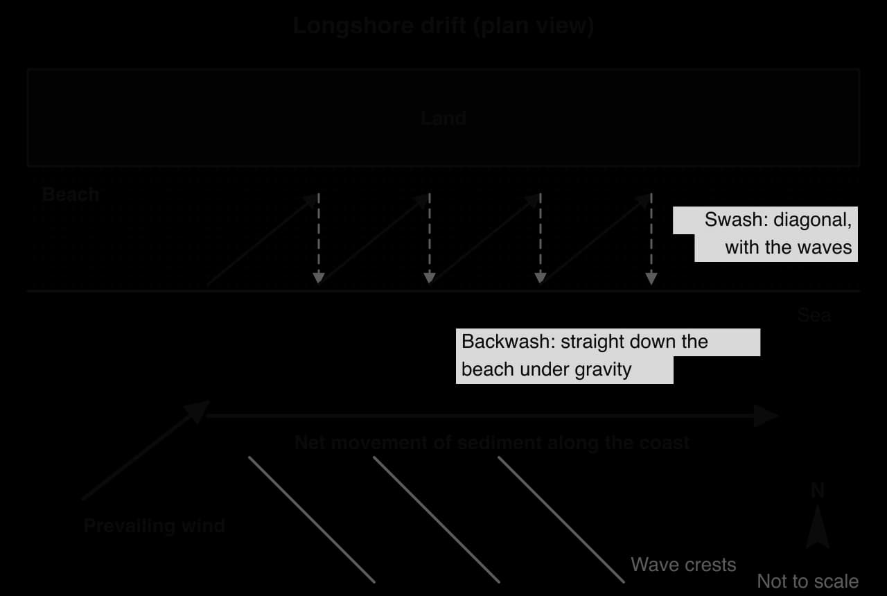
The direction of longshore drift can be worked out from the prevailing wind and the orientation of the coast, often shown on a rose diagram, and confirmed in the field by the build-up of sediment against one side of groynes, by tracing marked pebbles, or by the direction in which spits grow.
A study recorded the direction of waves approaching a straight beach running west–east with the sea to the south over 50 days (hypothetical data).
Direction waves came from | N | NE | E | SE | S | SW | W | NW |
|---|---|---|---|---|---|---|---|---|
Number of days | 0 | 0 | 4 | 6 | 12 | 21 | 7 | 0 |
A cliff is a steep rock face along the coast. Wave erosion is concentrated in the zone between high and low tide, so a wave-cut notch forms at the base of the cliff by hydraulic action and abrasion. As the notch deepens, the rock above is left as an overhang, which eventually collapses under its own weight. The waves remove the debris and the process repeats, so the cliff retreats inland. Behind it, the waves leave a gently sloping rock surface, usually under about 4°, called a wave-cut platform, exposed at low tide.
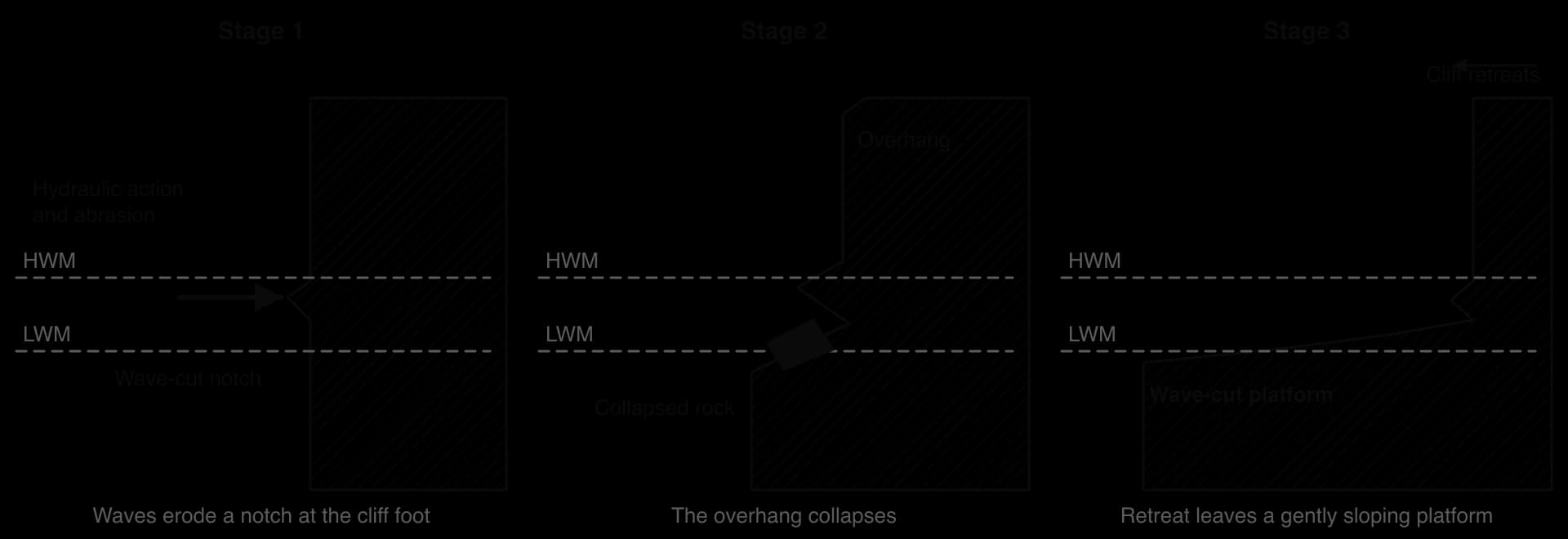
Wave-cut platforms limit their own growth, an example of negative feedback. As the platform widens, waves break further out and lose much of their energy crossing it before reaching the cliff, so erosion at the cliff foot slows. Platforms are typically a few hundred metres wide; they are widest where the tidal range is large, because the waves attack a wider vertical band of the shore.
 YouTube
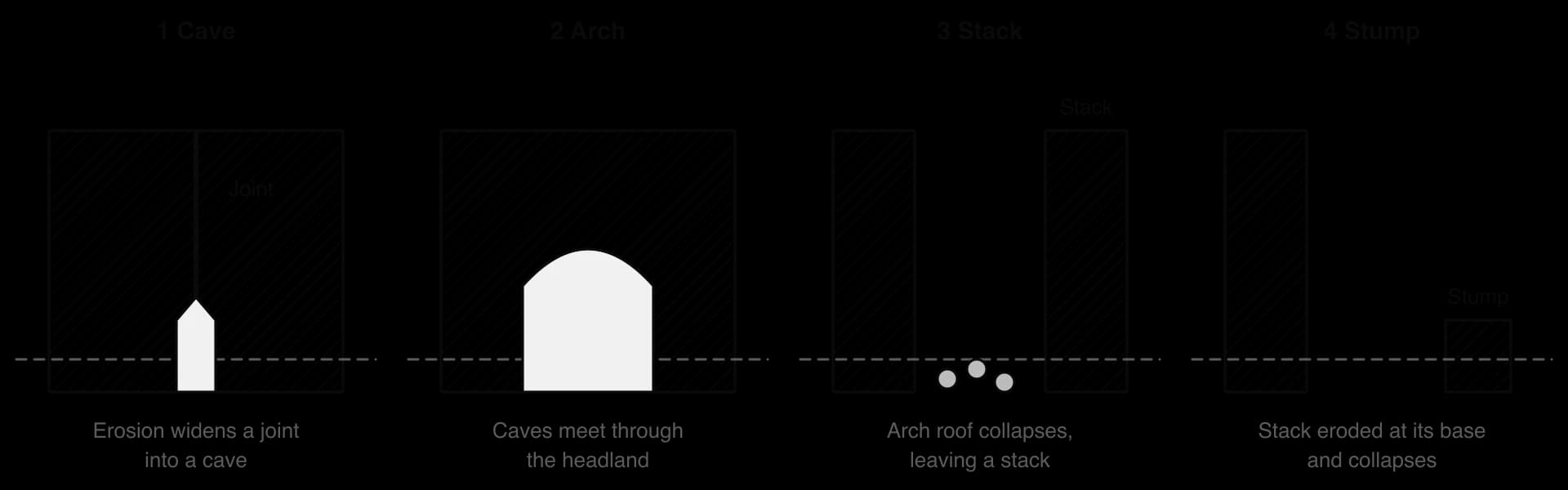
Headlands form where resistant rock projects into the sea, and wave refraction concentrates energy on them. Their sides are eroded along lines of weakness in a sequence of landforms.
Cave. Hydraulic action and abrasion enlarge a joint or fault at the base of the headland into a cave.
Arch. Caves on either side of the headland erode back until they meet, or one cave cuts right through, forming an arch.
Stack. Waves erode the base of the arch while weathering attacks its roof, until the roof collapses and leaves the seaward end standing as an isolated pillar, a stack.
Stump. The stack is undercut at its base and eventually collapses, leaving a low stump, often covered at high tide.
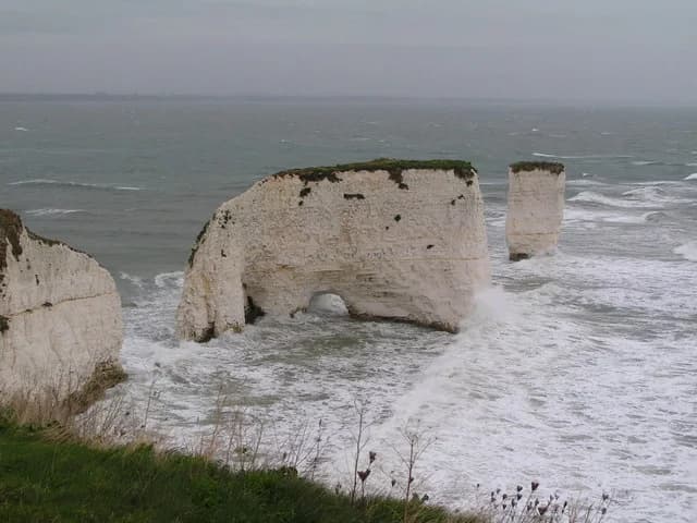
The sequence is still active on many coasts. On the Isle of Purbeck, Old Harry Rocks are chalk stacks and a stump at the tip of Handfast Point. In Victoria, Australia, the Twelve Apostles are limestone stacks up to 50 m high cut from the Port Campbell Limestone; a 50 m stack collapsed in July 2005 and another in 2009, leaving seven.
Nearby, the double-span “London Bridge” arch lost its landward span on 15 January 1990, stranding two tourists on the new stack, and in Malta the Azure Window, a limestone arch on Gozo, collapsed in a storm on 8 March 2017. Smaller features include geos, narrow inlets eroded along a fault, and blowholes, where a cave roof is pierced and spray is forced upwards.
Sources: Wikipedia, “Twelve Apostles (Victoria)”, “London Arch”, “Azure Window” and “Old Harry Rocks” (accessed 2026).
Deposition happens where waves lose energy and can no longer carry their load: in sheltered bays, behind headlands, where the coastline changes direction and where constructive waves dominate. Large supplies of sediment and gentle offshore slopes favour depositional coasts.
A beach is an accumulation of sand or shingle between the low water mark and the highest point reached by storm waves. Sand beaches have gentle slopes because sand packs tightly, so much of the swash returns as backwash and carries sediment down the beach. Shingle beaches are steeper because water percolates quickly through the gaps between pebbles, the backwash is weak and the pebbles are left behind at the top of the swash.
Beaches change with the season. In summer, constructive waves build a steep profile with a berm, a ridge at the top of normal high tides. In winter, destructive waves comb the beach down, flatten its profile and carry sand offshore into bars, and storm waves throw shingle to the back of the beach as a storm ridge. The lower beach may show ridges and runnels, parallel ridges of sand separated by shallow channels, and beach cusps, regular crescent-shaped hollows in the upper beach.

In plan view, beaches are of two types. Swash-aligned beaches form where waves arrive parallel to the coast, as in enclosed bays, so sediment moves up and down the beach rather than along it and the beach lies parallel to the wave crests. Drift-aligned beaches form where waves arrive at an angle, so longshore drift moves sediment along the coast and the beach lines up with the direction of drift.
A spit is a long, narrow ridge of sand or shingle attached to the land at one end, with the other end projecting into the sea or across the mouth of an estuary. It forms in a series of steps.
Longshore drift carries sediment along the coast in the direction of the prevailing waves.
The coastline changes direction, for example at a river mouth or a bay, but the drift continues in a straight line.
Deposition builds out into the sea as the waves lose energy in the deeper or sheltered water, and the ridge grows longer.
The end curves. Waves refracted around the tip, and waves from a secondary wind direction, curve the end landward into a recurved hook; a spit may have several hooks from earlier stages.
A saltmarsh forms behind it. The sheltered, low-energy water between the spit and the land allows fine mud to settle, and salt-tolerant plants colonise it.
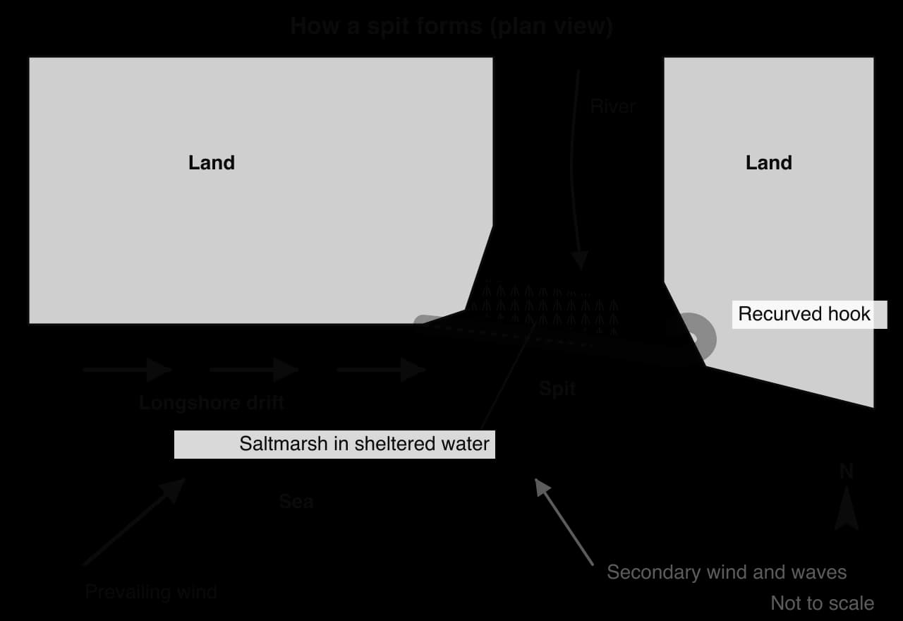
Farewell Spit, at the northern tip of the South Island of New Zealand, is the longest sand spit in the country, with about 25 km of stable land. Spurn Head, at the southern end of the Holderness coast, is a curved spit about 5 km long across the mouth of the Humber, made of sediment carried south by longshore drift.
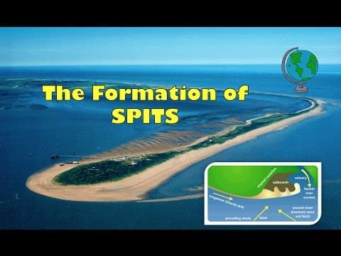 YouTube
A bar forms when a spit grows right across a bay, joining two headlands and trapping a lagoon behind it. Slapton Sands in Devon is a shingle barrier enclosing Slapton Ley, the largest natural freshwater lake in south-west England.
A tombolo is a ridge of sand or shingle joining an island to the mainland. St Ninian’s Isle in Shetland is joined to the mainland by a 500 m sand tombolo, the largest in the UK. Chesil Beach in Dorset, a 29 km shingle ridge linking the Isle of Portland to the mainland, is often called a tombolo, though research shows it is a barrier beach that has migrated landward.
A cuspate foreland is a triangular area of shingle built where longshore drift from two directions meets, as at Dungeness in Kent, one of the largest expanses of shingle in Europe.
Barrier islands are long offshore islands of sand parallel to the coast, separated from it by lagoons, as along the Atlantic and Gulf coasts of the USA.
These features are linked by the same processes: each is a store in a sediment cell, built where longshore drift deposits material, and each can be destroyed if the sediment supply falls or storms breach it.
Sources: Wikipedia, “Farewell Spit”, “Spurn”, “Slapton Ley”, “St Ninian’s Isle”, “Chesil Beach” and “Dungeness (headland)” (accessed 2026).
An advancing (prograding) coastline grows seaward, through deposition or a fall in sea level relative to the land. A retreating coastline moves inland, through erosion or a rise in sea level relative to the land. Over thousands of years, the most important control is the changing level of the sea against the land.
Eustatic change is a global change in sea level caused by a change in the volume of water in the oceans. During glacial periods, large amounts of water were stored on land as ice sheets, so sea level fell: at the Last Glacial Maximum, between about 26,000 and 20,000 years ago, it was about 120–125 m lower than today. As the ice melted, sea level rose rapidly until about 7,000 years ago.
Today sea level is rising again, through the thermal expansion of warming water and the melting of glaciers and ice sheets; the rate reached about 4.6 mm a year in 2013–2022, and global mean sea level rose by about 20 cm between 1901 and 2018.
Isostatic change is a change in the level of the land relative to the sea. The most important kind is glacio-isostatic rebound. The weight of an ice sheet, up to several kilometres thick, pushes the Earth’s crust down into the mantle; when the ice melts, the crust slowly rises again.
The northern Gulf of Bothnia, between Sweden and Finland, is still rising by about 11 mm a year, and northern Britain, once covered by thick ice, is rising by up to 10 cm a century, while southern England, beyond the ice margin, is sinking by up to 5 cm a century. Tectonic uplift and the sinking of heavy delta sediments also cause isostatic change.
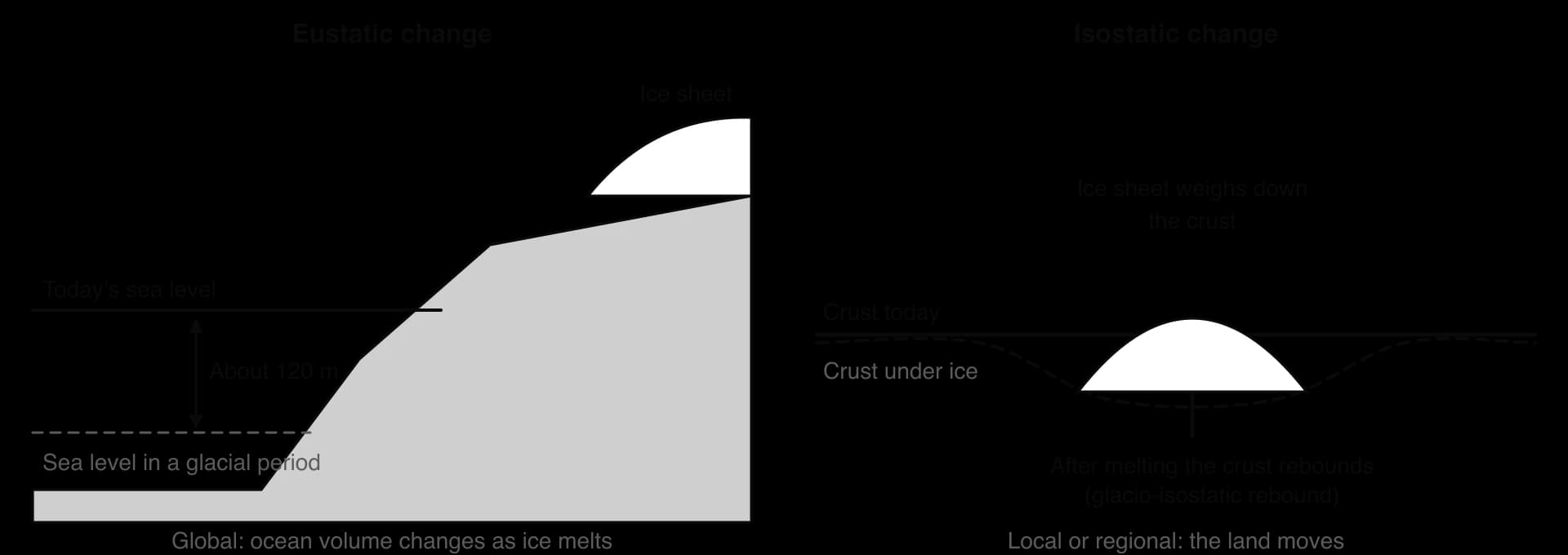
The crust responds slowly because the mantle beneath it flows only very slowly, so rebound continues thousands of years after the ice has gone.
Relative sea-level change is the change in sea level measured against the land at a particular place: the combined result of eustatic and isostatic change. A tide gauge measures exactly this. At Stockholm, the land has risen faster than the global sea, so relative sea level fell by about 3.5 mm a year between 1916 and 2024. At Newlyn in Cornwall, the land is sinking slightly while the global sea rises, so relative sea level rose by about 2 mm a year, and by about 4.6 mm a year since 1993.
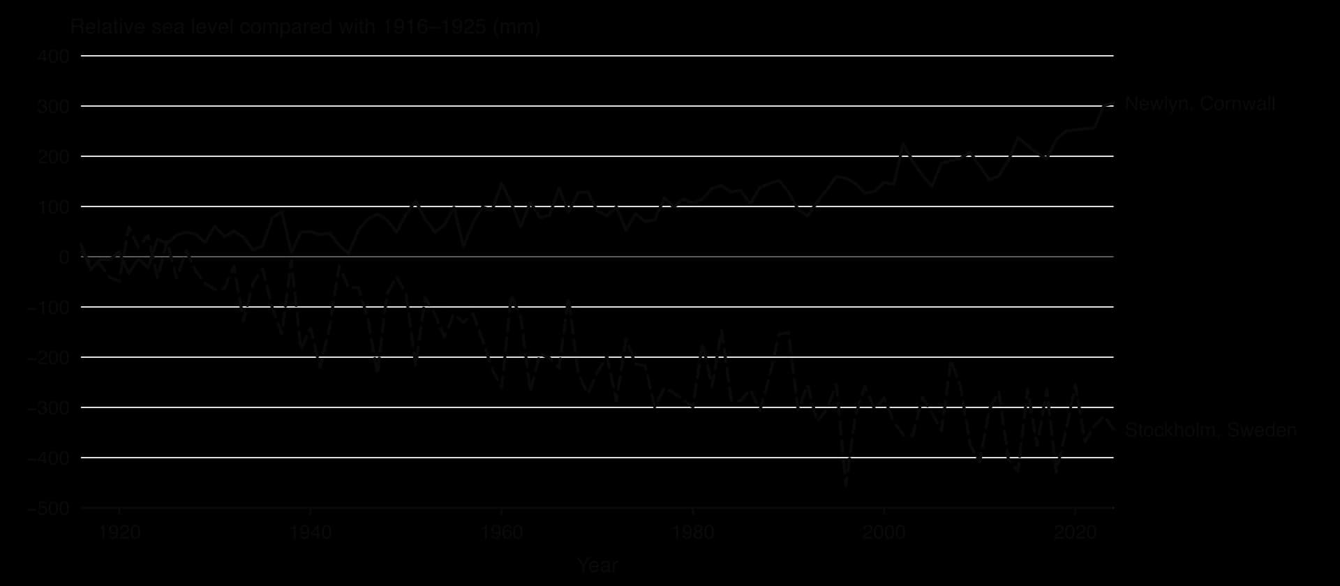
Sources: Permanent Service for Mean Sea Level (PSMSL), revised local reference annual data for Stockholm (station 78) and Newlyn (station 202), retrieved 2026; trends calculated by least squares. Wikipedia, “Post-glacial rebound”, “Last Glacial Maximum” and “Sea level rise”, citing USGS, IPCC AR6 and WMO (accessed 2026).
An emergent coastline forms where the land has risen relative to the sea, leaving former shorelines above the reach of today’s waves. Its typical landforms are the raised beach, a flat terrace of old beach deposits now above sea level, often at 5–10 m or higher, and the relict cliff behind it, a former sea cliff, sometimes with old caves, arches and notches, now separated from the sea and being worn down by weathering. The west coasts of Jura and Arran in Scotland, where the land has risen since the ice sheet melted, have raised beaches of international importance.
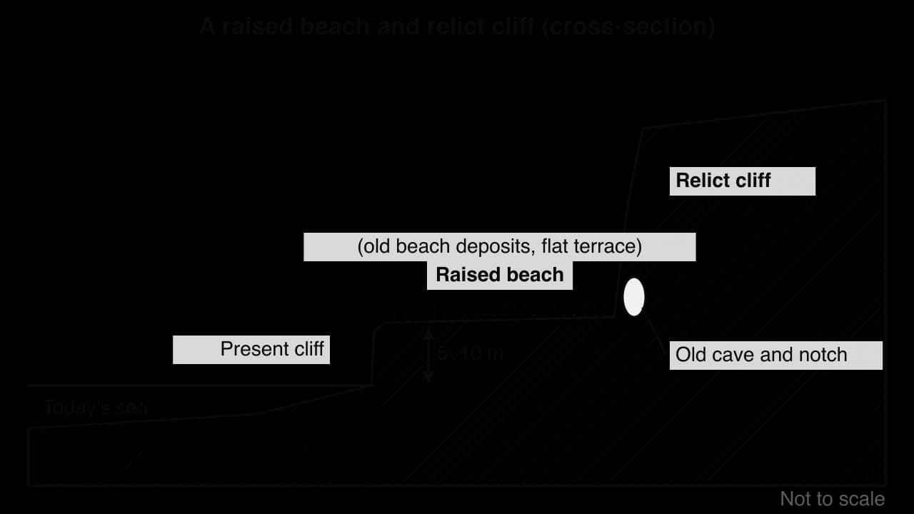
Where the land rose in stages, a coast can have several raised beaches at different heights, one above another; the highest is the oldest, because it was raised first.
Raised beaches can be recognised on a topographic map as a narrow strip of flat land at a constant height, often 5–10 m above sea level, with a steep slope (the relict cliff) on its landward side and roads or villages built along it.
A submergent coastline forms where the sea has risen relative to the land, drowning former land features. The main landforms are fjords and rias.
A fjord is a drowned glacial trough: a long, narrow, steep-sided and very deep inlet, carved by a glacier and flooded by the sea as the ice melted and sea level rose. Fjords are deepest inland and have a shallow rock threshold near the mouth, where the glacier lost erosive power as it spread out and dropped moraine. Sognefjord in Norway runs 205 km inland, reaches 1,308 m deep and has a sill only about 100 m below sea level near its mouth.
A ria is a drowned river valley, formed when rising sea level flooded an unglaciated river valley. Rias are broad and deep at the mouth and become shallower and narrower inland, with a branching plan like the river system they drowned. The rías of Galicia in north-west Spain gave the landform its name; the Kingsbridge Estuary in Devon is so large compared with its small streams that it can only be a drowned valley.

The glacial troughs that fjords occupy were carved by glacial erosion in cold environments; they became fjords when sea level rose after the glaciers melted and drowned them. A Dalmatian coast, as in Croatia, is a submerged concordant coast where long valleys parallel to the shore have been flooded, leaving lines of long islands.
The two landforms have different distributions. Fjords are found on coasts that were heavily glaciated, such as Norway, southern Chile, British Columbia and Fiordland in New Zealand, while rias are found on unglaciated coasts beyond the ice margin, such as south-west England and north-west Spain.
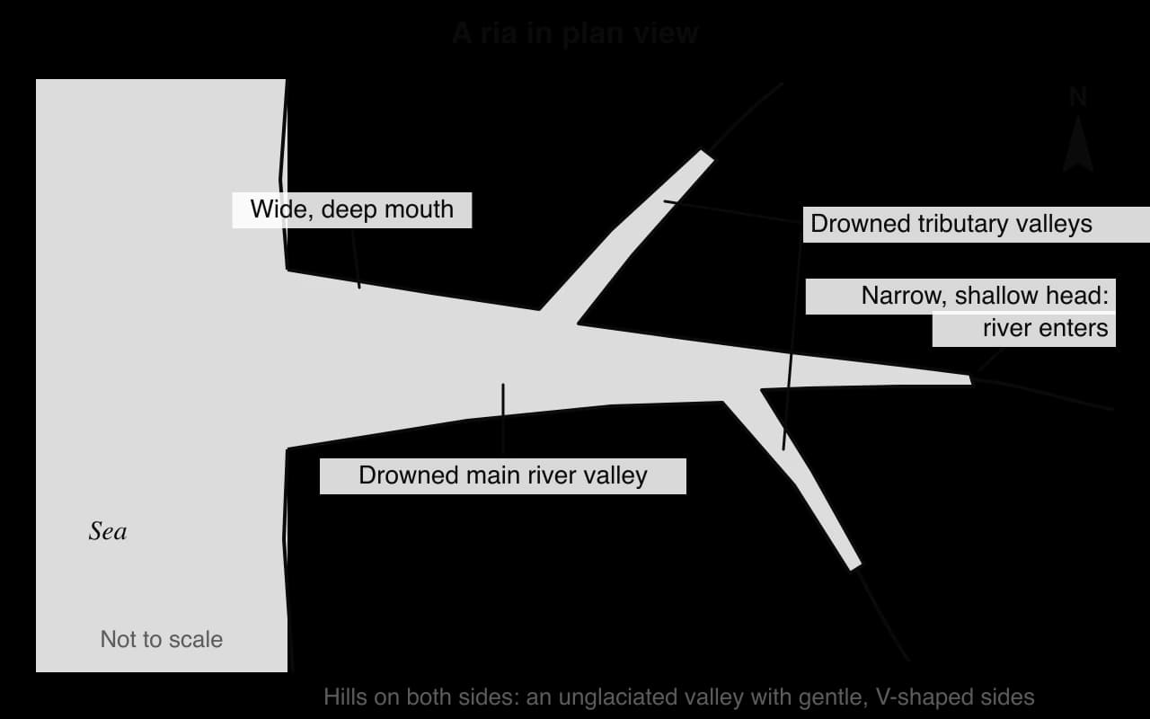
Sources: Wikipedia, “Sognefjord”, “Ria”, “Fjord”, “Kingsbridge Estuary” and “Raised beach” (accessed 2026).
A sand dune is a ridge or mound of wind-blown sand. Coastal dunes form where four conditions occur together: a large supply of sand; a wide, gently sloping beach with a large tidal range, so that a broad area of sand dries out at low tide; strong onshore winds to move it; and obstacles such as driftwood, seaweed or plants that slow the wind so the sand is deposited. Wind moves sand by saltation, in which grains bounce along the surface, and by surface creep, in which larger grains are rolled and pushed along by the impact of bouncing grains.
Dunes inland from a beach form a sequence that gets older, more stable and more vegetated away from the sea. This change in plant communities over time is succession, and a succession that begins on bare sand is called a psammosere.
Embryo dunes form at the top of the beach, where sand collects around obstacles. Pioneer plants such as sea couch grass, which tolerate salt spray, burial and drought, colonise them and trap more sand. They are small and unstable.
Foredunes (yellow dunes) are higher, up to 5–10 m, and still mobile; the sand between the plants is bare, which gives them their yellow colour. They are dominated by marram grass, which thrives as it is buried.
Grey dunes lie further inland and are more stable. Dead plant material adds humus, which darkens the sand and holds water, and mosses, lichens and flowering plants such as sea buckthorn grow; the soil becomes more acidic as shell fragments are leached.
Dune slacks are damp hollows between dune ridges where the surface is close to the water table; they support reeds, rushes and willows and are important habitats, such as for natterjack toads on the Sefton coast near Liverpool.
Mature (fixed) dunes furthest inland are stable and covered by heath, scrub or woodland of heather, gorse, birch and pine, with acidic soils of pH 4–5.
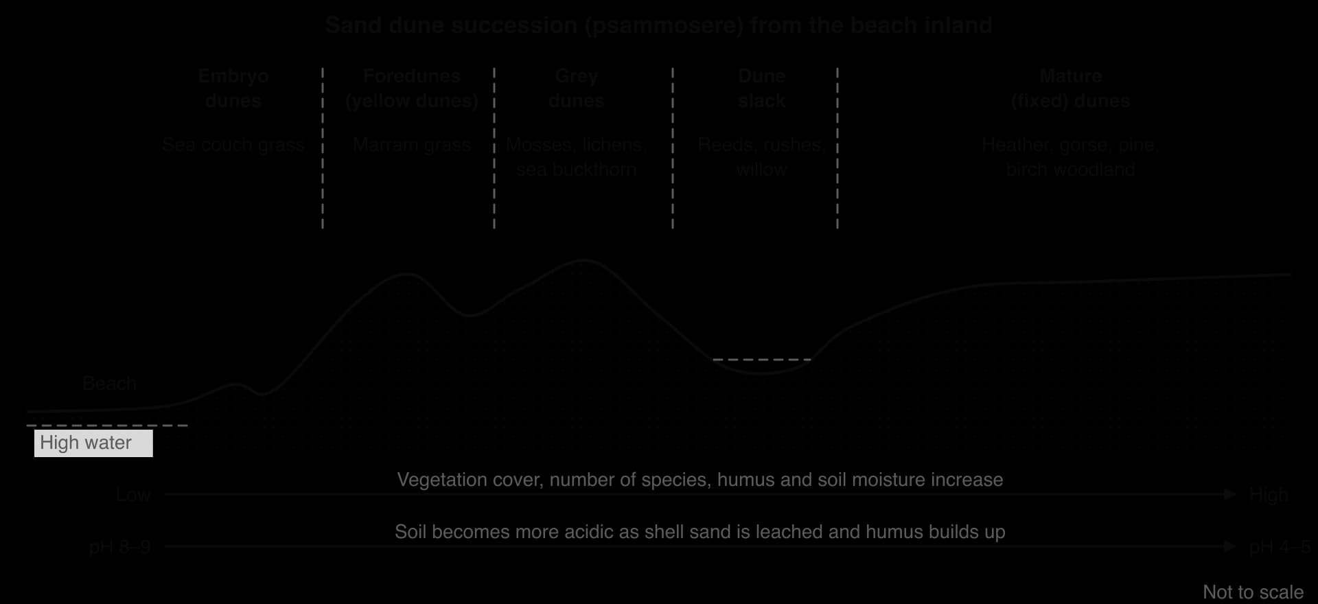
Marram grass is the key species. Its long leaves roll inwards in dry weather, reducing water loss, and its roots reach over a metre deep to find water; it grows faster when buried by sand, so the dune grows with it.
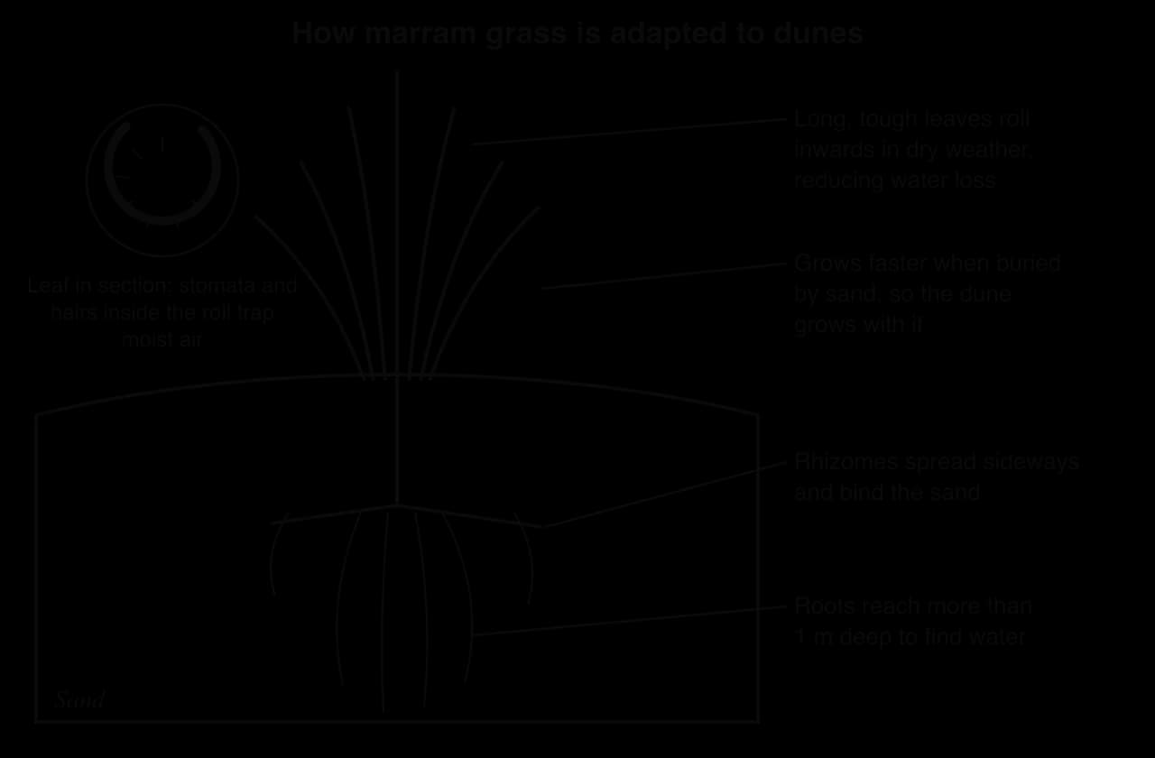
As marram traps sand and adds humus, it changes conditions so that other plants can grow and gradually replace it, the essence of succession. Studland Bay in Dorset shows a complete psammosere that has built up since the 17th century and is managed by the National Trust.
Dunes are easily damaged. A blowout is a hollow scooped out by the wind where the vegetation cover has been broken, by trampling, grazing, rabbits, fire or a storm. Once the sand is exposed, the wind removes it rapidly and the hollow grows, sometimes cutting right through a dune ridge. Storm waves can also cut back the front of foredunes. On the Curonian Spit, a 98 km dune spit shared by Lithuania and Russia, the clearance of forests in the 18th century let the dunes move and bury whole villages; replanting began in 1825, and the spit is now a UNESCO World Heritage Site.
The Dune of Pilat in south-west France, more than 100 m high, is the tallest sand dune in Europe and is still moving slowly inland over the forest behind it. Dune management, such as fencing, boardwalks, replanting marram and controlling access, is part of coastal management.
Sources: Wikipedia, “Ammophila arenaria”, “Studland”, “Sefton Coast”, “Curonian Spit” and “Dune of Pilat” (accessed 2026).
Dune fieldwork usually measures these changes along a transect from the beach inland (hypothetical data).
Distance from high water (m) | 20 | 60 | 120 | 200 | 300 |
|---|---|---|---|---|---|
Vegetation cover (%) | 10 | 45 | 80 | 95 | 100 |
Soil pH | 8.6 | 8.1 | 7.0 | 5.8 | 4.6 |
Number of plant species | 2 | 4 | 9 | 12 | 15 |
The Holderness coast of the East Riding of Yorkshire is one of the fastest-eroding coastlines in Europe. It shows, along one stretch of coast, how lithology, waves, longshore drift, subaerial processes and a sediment cell work together, and how human interference in one place changes the coast elsewhere.
Holderness runs from the chalk headland of Flamborough Head in the north to Spurn Head at the mouth of the Humber Estuary in the south. Behind the coast lies a low plain of glacial till (boulder clay) and lake clays, laid down by ice during the Devensian glaciation, which infilled a former bay in the chalk. Towns such as Bridlington, Hornsea and Withernsea, villages, caravan parks, farmland and the gas terminals at Easington and Dimlington sit on or close to the cliff top.
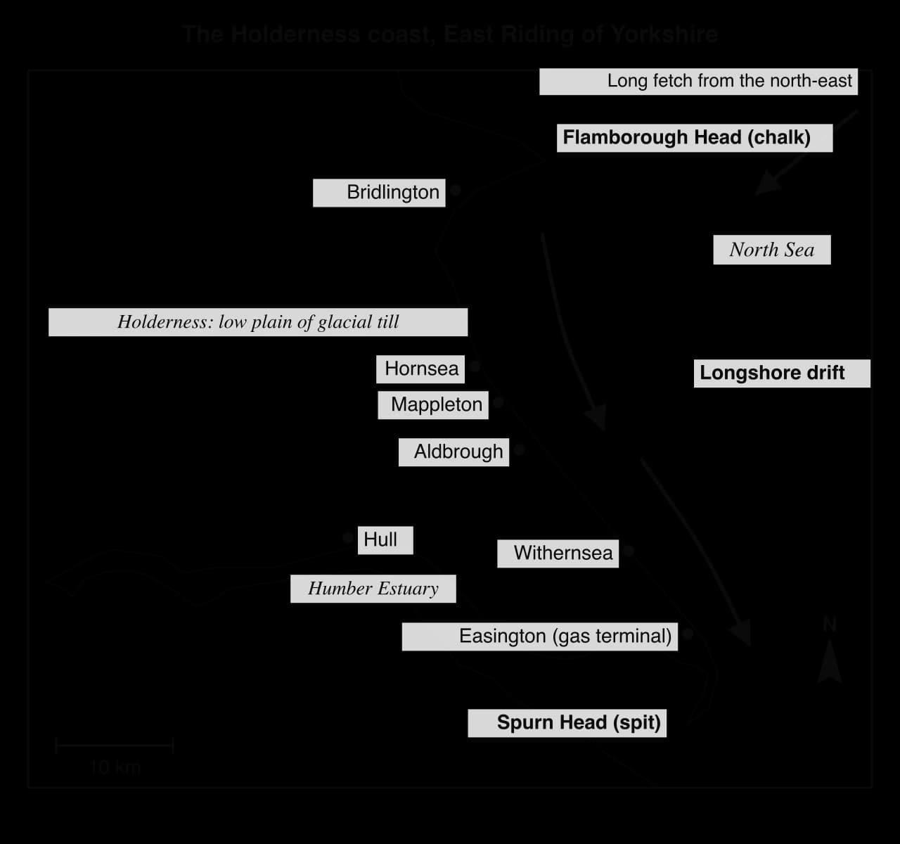
Lithology. Glacial till is a weak, unconsolidated mixture of clay, sand and boulders that offers little resistance to waves and slumps easily when wet.
Waves. The coast faces a long fetch across the North Sea from the north-east, so winter storms bring powerful destructive waves; about 70% of cliff loss between 2003 and 2025 happened in winter.
Narrow beaches. The till contains little sand and shingle, so the beaches are narrow and thin; they give the cliffs little protection, and storm waves reach the cliff foot.
Subaerial processes. Rain soaks into the cliffs, raising pore-water pressure and causing rotational slides; the slumped material is quickly removed by the waves, keeping the cliff steep and unstable.
Longshore drift. Fine clay is carried away in suspension and most of the sand and shingle is moved south by longshore drift, so the eroded material does not stay to protect the cliff.
The cliffs retreat on average by about 1.5 m a year, releasing about 2 million tonnes of material a year. About 5 km of land has been lost since Roman times, together with at least 23 towns and villages, including the medieval port of Ravenspurn. Only about 3% of the eroded material reaches Spurn; most fine sediment is carried offshore or into the Humber.
Sources: Wikipedia, “Holderness”, citing East Riding of Yorkshire Council and the British Geological Survey (accessed 2026).
East Riding of Yorkshire Council measures the position of the cliff top every spring and autumn at 123 profiles spaced about 500 m apart along the coast. Between 2003 and 2025 the whole coast lost an average of 1.40 m a year, and the undefended cliffs 1.65 m a year. The chart shows how unevenly that loss is spread.
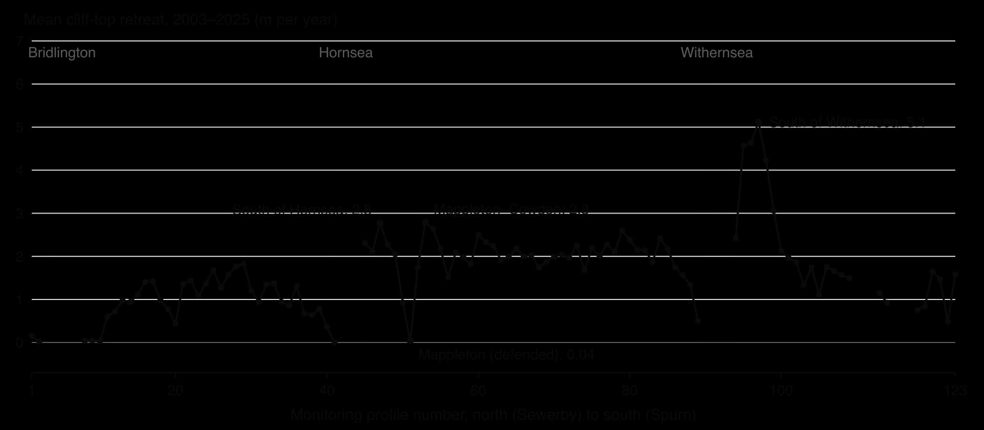
The defended towns stand out as gaps or troughs, and the highest rates lie immediately south of them, in the direction of longshore drift.
At Mappleton, two rock groynes and a rock revetment built in 1991 cut erosion at the village, which had been losing about 1.7 m a year between 1952 and 1989, to almost nothing (0.04 m a year from 2003 to 2025). The groynes trap sediment that would have drifted south, so the coast just south of the village lost up to 2.8 m a year over the same period, and in the years after 1991 erosion there rose sharply. South of the Withernsea defences, rates of 4.6–5.1 m a year are among the highest on the coast.
Profile location | Mean cliff-top retreat, 2003–2025 (m per year) |
|---|---|
North of Mappleton | 0.93 |
Mappleton (defended since 1991) | 0.04 |
South of Mappleton | 1.75 |
Between Mappleton and Cowden | 2.79 |
North of Withernsea defences | 0.51 |
South of Golden Sands, Withernsea | 4.57 |
Opposite sewage works, Holmpton Road | 5.12 |
Sources: East Riding of Yorkshire Council cliff monitoring data, summarised by urbanrim.org.uk (data summary to 2025, accessed October 2026); Wikipedia, “Mappleton” and “Holderness” (accessed 2026).
At the southern end of the cell, sediment carried by longshore drift has built Spurn Head, a curved spit of sand and shingle more than 5 km long and in places only about 45 m wide, reaching across the mouth of the Humber. Like the cliffs to the north, the spit migrates westward, keeping pace with the retreating coast, and history records it being breached and rebuilt many times.
A tidal surge in December 2013 broke through its narrow neck and destroyed the road, so Spurn is now a tidal island at high tide. It has been owned since 1960 by the Yorkshire Wildlife Trust as a nature reserve, and in 2023 the RNLI moved its lifeboat station from the tip to Grimsby after the jetty was found to be unsafe.
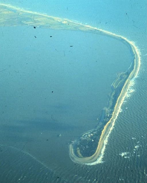
Sources: Wikipedia, “Spurn”, citing the Yorkshire Wildlife Trust and the RNLI (accessed 2026).
The impacts fall mainly on farmers, owners of cliff-top homes and caravan parks, and small communities such as Skipsea, Aldbrough and Kilnsea, which lose land every year and are not protected because defending them would cost more than the property is worth. The defended towns gain security, but at the expense of the coast to the south. The gas terminals at Easington, of national importance, have their own defences. Who is protected, and who pays for the effects downdrift, is a question of power and equity for coastal management.
Concept | How Holderness shows it |
|---|---|
Process | Weak till, a long north-east fetch, destructive winter waves, rotational slumping and longshore drift combine to produce rapid retreat |
Place | The same processes threaten very different places: towns, villages, caravan parks, farms and an internationally important gas terminal |
Spatial interactions | The coast is one sediment cell: defences at Hornsea, Mappleton and Withernsea starve beaches downdrift, and the spit at Spurn depends on erosion further north |
Power | Defences protect towns with high property values and infrastructure, while farmland and small settlements are left to erode |
Examine the relative importance of lithology and wave energy in explaining the rate of erosion on the Holderness coast.
Using the cliff-monitoring data, explain why erosion is fastest just south of the defended frontages.
Suggest how Spurn Head might change if the whole Holderness coast were protected by sea walls.
Paper 1 questions on coastal processes and landforms usually give a photograph, sketch or topographic map extract of a coast, a beach profile, a rose diagram or a graph of erosion data, followed by questions on processes and landforms; extended answers ask for the formation of landforms or the relative importance of factors.
Stimulus. Mean cliff-top retreat at selected profiles on the Holderness coast, 2003–2025 (East Riding of Yorkshire Council data).
Profile | Mappleton (defended) | South of Mappleton | Between Mappleton and Cowden | South of Withernsea (Golden Sands) |
|---|---|---|---|---|
Retreat (m per year) | 0.04 | 1.75 | 2.79 | 4.57 |
Waves form by wind over a fetch; their energy rises with the square of their height, and they break when the sea bed slows their base in shallow water.
Constructive waves (strong swash) build beaches; destructive waves (strong backwash) remove sediment; refraction concentrates wave energy on headlands and spreads it in bays.
Tidal range, set by spring and neap tides and the shape of the coast, controls the vertical zone in which waves work.
Sediment cells link sources, transfers and sinks, so interference in one place, such as defences at Mappleton, changes erosion downdrift.
Lithology, structure (concordant and discordant coasts), vegetation and subaerial weathering and mass movement control how fast and in what form coasts erode.
Hydraulic action and abrasion cut notches, wave-cut platforms, caves, arches, stacks and stumps; longshore drift and constructive waves build beaches, spits, bars and tombolos.
Relative sea-level change combines eustatic change (global sea volume) and isostatic change (land movement): emergent coasts have raised beaches and relict cliffs; submergent coasts have fjords and rias.
Coastal dunes form where large, dry sandy beaches meet onshore winds and vegetation; succession runs from embryo dunes to mature fixed dunes, with pH falling inland.
Holderness shows rapid erosion of weak till by North Sea waves, southward longshore drift feeding Spurn Head, and faster erosion just south of defended towns.
I can explain how waves form and break and distinguish constructive from destructive waves.
I can explain wave refraction, tides and sediment cells, and how they influence coastal landscapes.
I can explain hydraulic action, abrasion and longshore drift, and draw a longshore drift diagram.
I can explain the formation of cliffs, wave-cut platforms and the cave–arch–stack–stump sequence with annotated diagrams.
I can explain the formation of beaches, spits, bars and tombolos.
I can distinguish eustatic from isostatic change and explain raised beaches, relict cliffs, fjords and rias.
I can explain sand dune succession and the roles of wind, vegetation and coastal processes.
I can interpret erosion, tide-gauge and transect data and use the Holderness coast as an extended example.
Dune regeneration (fencing, marram grass planting, boardwalks) and salt-marsh creation absorb wave energy and provide habitat, but need space and can be damaged by storms or trampling.
Managed realignment (eg Medmerry, West Sussex, 2013) creates intertidal habitat that absorbs wave energy, but requires land to be given up, which affects farmers and landowners.
Effectiveness depends on context: wave energy, sediment supply, geology and the value of what is being protected.
Good answers may be well structured (AO4) and may additionally offer a critical evaluation (AO3) which examines the circumstances in which each approach is most appropriate (places), for example hard engineering in front of dense urban areas and soft engineering on lower-value or ecologically sensitive coasts. Another approach might be to consider time scales: hard engineering may be effective in the short term but unsustainable in the long term as sea levels rise, while soft engineering adapts to change (possibilities). Another approach might be to consider that the most successful schemes often combine the two (eg rock armour at the toe of a nourished beach), so the distinction is not absolute, or to consider who pays and who benefits (power).
For 5–6 marks, expect some weakly-evidenced outlining of hard and soft engineering strategies, possibly with limited evaluation.
For 7–8 marks, expect a structured account which includes:
either well-evidenced explanation of the strengths and limitations of both hard and soft engineering, with located examples
or a discursive conclusion (or on-going evaluation) grounded in geographical concepts and/or perspectives.
For 9–10 marks, expect both of these traits.
NB. If only hard or only soft engineering is evaluated, award up to a maximum of [5]. Do not expect perfect balance.
Marks | Level descriptor |
|---|---|
0 | The response does not reach a standard described by the descriptors below. |
1–2 | Too brief, lists unconnected information, not focused on the question and lacks structure. Knowledge is very general, with large gaps or errors; examples or case studies are missing or only listed. No analysis; terminology is missing or used incorrectly. |
3–4 | Too general, lacks detail, not focused on the question and largely unstructured. Outlines examples, statistics and facts, both relevant and irrelevant, with links to the question only listed. Basic terminology is used, with errors or inconsistently. No critical evaluation of evidence; any conclusion is irrelevant. |
5–6 | Partially addresses the question, with a narrow argument, an unsubstantiated conclusion and limited evaluation. Describes relevant supporting evidence (examples, case studies) and outlines links to the question. The argument repeats one point or covers only part of the question. Other perspectives, or strengths and weaknesses of evidence, are listed. |
7–8 | Addresses the whole question; the analysis is evaluated and the conclusion is relevant but lacks balance. Relevant evidence is described correctly and covers all the main points. The argument is clear but one-sided or unbalanced. Complex terminology is used correctly but not consistently. Other perspectives, or strengths and weaknesses of evidence, are described. |
9–10 | In-depth and specific to the question (topic and command term). Correct, relevant examples, statistics and detail are integrated and their link to the question explained. The argument is balanced, explaining complexity, exceptions and comparisons. Evaluation of evidence and perspectives is well developed, and the conclusion is balanced and aligned with the evidence. Logically structured and easy to follow. |
Evaluate the effectiveness of cliff line stabilization strategies in one or more named coastal places.
10 marks
To what extent is it possible to protect one stretch of coastline without increasing risk elsewhere?
10 marks